
From collection Creating Acadia National Park: The George B. Dorr Research Archive of Ronald H. Epp

Page 1
Page 2
Page 3
Page 4
Page 5
Page 6
Page 7
Page 8
Page 9
Page 10

Page 11
Page 12
Page 13
Page 14
Page 15
Page 16
Page 17
Page 18
Page 19
Page 20
Page 21
Page 22
Page 23
Page 24
Page 25
Page 26
Page 27
Page 28
Page 29
Page 30
Page 31
Page 32
Page 33
Page 34
Page 35
Page 36
Page 37
Page 38
Page 39
Page 40
Page 41
Page 42
Page 43
Page 44
Page 45
Page 46
Page 47
Page 48
Page 49
Page 50
Page 51
Page 52

Page 53
Page 54
Page 55
Page 56
Page 57
Page 58
Page 59
Page 60
Page 61
Page 62
Page 63
Page 64
Page 65
Page 66
Page 67
Page 68
Page 69
Page 70
Page 71
Page 72
Page 73
Page 74
Page 75
Page 76
Page 77
Page 78
Page 79
Page 80
Page 81
Page 82
Page 83
Page 84
Page 85
Page 86
Page 87
Page 88
Page 89
Search
results in pages
[Series III] Mount Desert Mountains Controversy Secondary Sources
Mount Desert Mountains
Controversy: Secondary Sources
Better
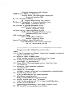
WOODLAWN
M u S E u M
The Black House
MAINE'S
PREMIER HISTORIC
ESTATE
Summer 2005
A Property of the Hancock County Trustees of Public Reservations
vol. 2 no. 3
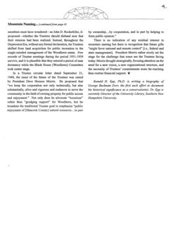
The Mountain Naming Controversy
and the Mission of the Trustees
Ronald H. Epp, Ph.D.
George Nixon Black, Jr., Col. John Black's grandson,
the Hancock County Trustees of Public Reservations, Mr.
bequeathed Woodlawn to the Hancock County Trustees
George B. Dorr, and other notable men and women who
of Public Reservations in 1928. One of Maine's first
were vital to the establishment of Acadia National Park.
preservation and land conservation organizations, this
Representatives from Hancock County libraries, museums,
group was founded in 1901 by Charles W. Eliot, the
and historical societies collaborated to plan a diverse
president emeritus of Harvard University and a summer
schedule of public events during 2005 that would focus
resident of Northeast Harbor. In 1916, this group donated
on the park Founders. This essay on the Trustees is one
the majority of the land that created Acadia National Park.
contribution to preservation of that legacy.
Today, Woodlawn Museum is the largest and most important
unit under the care of the Trustees. Public access to this
It is impossible to imagine a world without names. In
important historic estate has been maintained by the Trustees
an ideal world confusion would be avoided if everyone used
since its opening on August 20, 1929 under the leadership
one name to represent a person, place, or thing. Names
of Mr. Richard W. Hale, founder of the prestigious Boston
often have synonyms and spelling variations that contribute
law firm of Hale and Dorr, and Chairman of the Trustees'
to misunderstandings. Moreover, historic names give way
newly formed Black House Committee.
to current local usage and place names change with little
In 2004, a volunteer organization named "The Spirit
regard to their origin.
of Acadia" was formed to focus attention on the legacies of
continued on page 3..
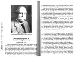
2.
Mountain Naming (continued from page 1)
There is a long-standing 'democratic' conviction in
America that everyone has an equal right to bestow-and
defend-a geographic name. To counter nomenclature
anarchy and confusion relating to geographic names, in the
late 19th century the United States Board on Geographic
Names (Board) established nomenclature criteria and
rendered decisions that were binding for Federal agencies.
The Woodlawn Archives provide rich insights into a
naming controversy that surfaced on the heels of the 1928
donation of the Woodlawn estate to the Hancock County
Trustees of Public Reservations (Trustees). The central
figure in this controversy was George Bucknam Dorr
(1853-1944), one of the eight Trustee Incorporators and its
First Vice President for more than four decades. Mr. Dorr's
energetic stewardship over three decades was responsible
for most Trustee donations and the eventual gifting of these
properties to the federal government, establishing the Sieur
de Monts National Monument in 1916.
In 1917, as Monument Custodian, Mr. Dorr proposed
well-developed arguments for changing the names of nearly
a dozen natural objects within Monument boundaries to
the National Park Service (NPS). Receiving the necessary
NPS endorsements, he made formal application to the
Board on September 15, 1918 and within two weeks
new nomenclature was authorized. While the motives for
reference." As a new federal administrator, Dorr was also
mountain renamings were complex, Dorr argued in part that
trying to conform to the Board principle of long standing
the conventional names (e.g., Brown, Dog, Dry, Green etc.)
usage, yet as a scholar Dorr was compelled to locate historic
were undistinguished. As a result, nearly half the mountains
precedent for the conventional names. Where the historical
that form the Mount Desert Range were renamed Acadia,
roots were shallow, Dorr saw an opportunity to develop
Bernard, Cadillac, Champlain, Huguenot Head, Mansell,
alternative historical arguments that emphasized the role of
and Norumbega.
Native American and French historical associations. In this
Following the 1919 elevation of the Monument to
process he pressed for a more ancient lineage than what was
national park status (Lafayette National Park), other
customary on Mount Desert Island.
geographic name changes were proposed and by 1929
Boston attorney and Trustee Richard W. Hale initiated
approvals were secured to rename ten of fourteen
a defense of the traditional mountain names more than a
mountains-and island maps reflected these changes.
decade after the 1918 approvals. His January 2, 1931 letter
For Mr. Dorr, name selection resulted from extensive
to the editor of the Bar Harbor Times stated that at the August
study. The National Archives, Rockefeller Archive Center,
28, 1930 annual meeting of the HCTPR he entered a motion
the Board Archives, and the Sawtelle Research Center
to fellow Trustees that at the next annual meeting they
contain Dorr's arguments. He recognized that early
declare themselves in favor of the "well known names." An
settlers gave "excellent descriptive names" to the seacoast
informal Trustees poll, via postcard, revealed that 28 of 36
and harbored waters where names like Egg Rock and
favored the names in use before the Board approvals. Hale
Otter Creek suggest their own interesting ancestry. But
asked the Times to poll its readers. Over the next several
"mountains and paths, woods and lakes, must all have
weeks ballots were cast and the tally was overwhelming:
names for the sake of distinction and as points of visitor
150 for the old names, three for the new. Letters to the Times
3
3,
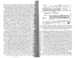
I am strongly in favor of
no documentation that the new name opponents collaborated
or that Superintendent Dorr responded in any way to
holding to the new names
public questioning of his administrative recommendations.
Privately, Ellsworth District Court Judge John A. Peters
with there historical sign Secause
advanced the popular misconception that if Green
for the maintains-
Mountain could be renamed Cadillac then logically Dorr
"ought to call another one 'Buick' and certainly a peak near
Champlain, Cadellae,
Seal Harbor ought to be called 'Ford''' (after its celebrated
resident, Edsel Ford). The Woodlawn Archives offer little
Noumhega, St. Sawew
to clarify this matter other than the draft of a proposed 1934
Bernard area thousand
speech by R.W. Hale Jr. with a handwritten notation that
the motion that all Trustee officers use traditional mountain
Times better than
names in "all documents and correspondence" was defeated
Green Bram, Bosete.
by a voice vote.
The naming controversy appears to be a manifestation
One change is enough heto
of the Trustees attempt to cope with a fundamental
change in their organizational mission, shifting from land
leave well enough alone
conservation for the public good to property preservation
and stewardship. Hale became the champion of a cohort
Charleen
dissatisfied with what had transpired with former Trustee
properties that were now under federal administration.
Perhaps some felt that Mr. Dorr had violated some unstated
2
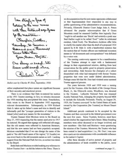
Ballot cast by Charles W. Eliot, September, 1930.
Trustee approval process.
The years between 1928 and 1930 were a turning
editor emphasized that place names are significant because
point for the Trustees. After the death of Mr. George Nixon
of their ancestry and emotional power.
Black, Jr., his Ellsworth estate, Woodlawn, was donated
There is no evidence that Hale re-entered his motion
to the Trustees. Lafayette National Park was renamed
at the 1931 Trustee meeting; in fact, no minutes document
Acadia National Park, enlarging the property beyond MDI
the 1930 meeting that precipitated this issue. Nonetheless,
to include the Schoodic Peninsula. Finally, on August 29,
Hale wrote to the Board in September 1932 requesting
1929, the Trustees conveyed "to the United States all lands
relevant documentation. Subsequently, in 1934 Richard
owned by the Corporation [the Trustees] on Mount Desert
Hale Jr. takes up his father's cause and tries to identify and
Island."
informally poll the "younger generation of visitors to the
Additional parcels continued to be accepted by the
Island [who] used new names for the mountains."
Trustees and then conveyed to the federal government over
Trustee Samuel Eliot Morison wrote to the Board on
the next few years. Some Trustees, however, must have
May 27, 1933 requesting that the names used prior to 1917
asked whether the organization had a future. Many founding
be restored. He argued that signage still reflected old usage,
members were either deceased or no longer involved, and
that the old names were reflected in American literature,
new members-like Hale and Morison-were questioning
and that the new names had not been popularly accepted.
the mission of the Trustees. Moreover, the Trustee who had
Morison concluded that if we can change the name of the
been central to land acquisition (i.e., Mr. Dorr ) was now
park to "the old French name of the region," (L'Acadie) we
also a park service administrator with considerable influence
can revert back to the old mountain names as well. Lacking
in the nation's Capitol.
support from the National Park Service, no action was taken
After three decades of active pursuit of property and
by the Board.
the administration of lands available to the public, some
Both Hale and Morison avoided making any reference to
fellow Trustee Dorr-as did the letters to the Times. There is
continued on page 11
4
4,
Mountain Naming (continued from page 4)
members must have wondered-as John D. Rockefeller, Jr.
by ownership
by cooperation, and in part by helping to
proposed-whether the Trustees should disband now that
form public opinion."
their mission had been realized. Instead, throughout the
There is no indication of any residual interest in
Depression Era, without any formal declaration, the Trustees
mountain naming but there is recognition that future gifts
shifted from land acquisition for public recreation to the
"might favor national and remote control" [i.e., federal and
single-minded management of the Woodlawn estate. Few
state management]. President Morris rather nicely set the
records of Trustee meetings during the period 1931-1939
stage for the challenge that some see the Trustees facing
survive, and it is plausible that they entered a period of near
today. Morris thought strategically, focusing attention on the
dormancy while the Black House (Woodlawn) Committee
need for a new vision, a new organizational structure, and
took center stage.
the necessity of Trustees' commitments more far-reaching
In a Trustee circular letter dated September 21,
than routine financial support.
1940, the issue of the future of the Trustees was raised
by President Dave Hennen Morris. He proposed that
Ronald H. Epp, Ph.D. is writing a biography of
"we keep the corporation not only technically, but also
George Bucknam Dorr, the first such effort to document
substantially, alive and vigorous and endeavor to serve the
his historical significance as a conservationist. Dr. Epp is
community in the field of owning property for public access
currently Director of the University Library, Southern New
and enjoyment." Not only does he advocate "luxurious"
Hampshire University.
rather than "grudging support" for Woodlawn, but he
broadens the traditional Trustee goal to emphasize "public
enjoyment of [Hancock County] natural resources in part
challenged in the public domain. The outcome would determine whether
the ballot box or federal authority reigned supreme on public lands.
Regional historians agree that the Wabanaki who visited Mount Desert
Island to feast on the bounty of the seas called its range of mountains
Pemetic. They also concur that when Samuel de Champlain explored the
waters of this Isle des Monts Deserts in 1604, the names he assigned certain
features came to dominate culturally to this day. Certainly Champlain was
iware of the presence of native seasonal inhabitants. More to the point,
11 is likely that members of this northeastern Algonquin-speaking tribal
nation guided Champlain to Pemetic.2
Cartographers, anthropologists, and historians might ask whether
Champlain's island naming constituted a renaming. Few would argue that
demonstrating the origin of geographic names has little value. Yet what
constitutes a sufficient, or even necessary, reason for a historically accepted
geographic name to be altered? In the absence of written documentation-
114 was the case with the Wabanaki prior to the mid-nineteenth century-
does an oral tradition carry sufficient authority? Prescriptively, whose
authority should dominate: the accepted originator, local custom, a
renaming advocate, or a legally-recognized authority?
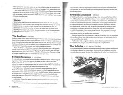
George B. Dorr, ca. 1940.
It is well known that Mr. Dorr's energetic stewardship was responsible for
Courtesy of Acadia National Park and the National Park Service
most of the donations to the Trustees of Public Reservations and the first gift of
more than five thousand acres to the federal government, establishing in 1916
the Sieur de Monts National Monument. For the next twenty-eight years,
Superintendent Dorr and the
Dorr had federal authority in the conservation of an expanding national asset
Mountain Naming Controversy
IIII Mount Desert Island. Yet as "custodian" of this new national monument,
Dor's authority was severely limited and federal policy required all proposed
Ronald H. Epp, Ph.D.
topographical name changes to be routed through an authoritative agency.
To counter nomenclature anarchy and confusion relating to geographic
ontroversy arose on Mount Desert Island early in the Great
names, an agency of the Department of Interior, the United States Board
t had its roots in the closing years of World War I. Workla
(III Geographic Names ("USBGN"), was established in 1890 to apply
m" residence in Bar Harbor in 1918, a gentleman "from
Ellieria and render decisions binding on federal agencies. ³ From 1918
I requests for federal approval to rename prominent natural
through 1934 Dorr submitted name change proposals, awaiting decisions
adopted island home. This gentleman was George Buckna
that customarily took a few weeks. Much later, after the mountain naming
44), the central figure in this controversy, one of the eight
Controversy subsided, Dorr wrote in his Memoirs that "none of the mountain
of The Hancock County Trustees of Public Reservations, and
names on the Island were old when we came down in 1868. There was no
tive officer. Dorr was the first administrator of federal land
need for them till summer folks came down and began to climb. For the
sert Island, and his renaming of the mountains would he
Indians and the early settlers alike they were simply a hunting grouni
roamed over by deer and bear." And their names? "The names given them
641.5
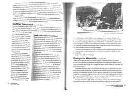
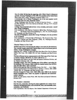
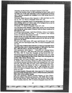
UNITED STATES GEOGRAPHIC BOARD
See work card
had no background in local usage or tradition or interest in themselves,
Cadillac Hincolle Co.,M
Following federal acquisition of the Sieur de Monts National Monume!
in 1916, the new park custodian stated that it was suggested to him by an
Mountain - highest point in Sieur de Monts
OCT 2 19 18
National Monument, Mount Desert Id. Maine,
"unnamed" party that it would be "better" if these new federal lands WE
Names
Authorities
related to "the old French occupation of the coast and its early history." MI
Green Min
Designation since 1355
Dorr collected, organized, and carefully studied the historical, lingulati
Mt. Newport
prior to 1855
and geological evidence before initially developing arguments for changir
Cadillac
Custodian,
Name proposed by Geo. B. Dorr representing the, "Wild.
the names of nearly a dozen natural objects within Monument boundarit
Gardens of Acadia, supported by the Sec: of the latr., Bureau
of Nat'l Parks, many Associations,and distinguished men, to
He concluded that "the mountains acquired names only from the summi
Local mange
commemorate early history and to Honor France for her
Green Mtn
part IM present War. Mount Desert Island deeded to Cadillac
visitors
none going beyond living memory." Armed with National
by Louis XIV,
Park Service endorsements, he made formal application to the USBC
Recommendation of Executive Committee
on September 15, 1918 and within two weeks the first nomencias
Submitted by
Gen B Darr Ind Dept
Cadillac
application was authorized. While his motives for mountain renami
Date
Sept 15, 1918
This card prepared by
&
were complex, Dorr argued in part that the conventional names-
Brown, Dog, Dry, Green, etc.-were undistinguished. That is, they W
11/11 request form completed by U.S. Board on Geographic Names chairman Frank Bond,
improuding to a request from Interior Department custodian George B. Dorr to standardize the
not imbued with connotations that resonated with worthy "histori
name of Cadillac Mountain, October 2, 1918. In Dorr's view, some of the conventional names were
associations," a criterion that Dorr employed with fierce allegiance.
"undistinguished." Courtesy of Executive Secretary, U.S. Board on Geographic Names
It is noteworthy that just prior to the 1916 federalization of donal
lands, Dorr was elected Selectman of the Town of Eden (now Bar Harb
Nillional Archives, the Rockefeller Archive Center, the USBGN Archives,
and subsequently re-elected for two terms through 1917. This civia and
and the Sawtelle Research Center at Acadia National Park contain Dorr's
political commitment surprised some of his contemporaries, for th
digaments. He recognized that early settlers gave "excellent descriptive
demands Dorr's horticultural and quarrying businesses-when combi
billites" to the seacoast and harbored waters where names like Egg Rock and
with the exhausting Monument initiative-appeared to leave little
One Creek suggest visual associations given by settlers. But "mountains and
for a new civic endeavor. Yet Dorr knew that he could use his lenderhip
paths, woods and lakes, must all have names for the sake of distinction and
position to influence cultural development beyond the confines of
#4 points of visitor reference." As a new federal administrator, Dorr was also
summer residents. Dorr was prescient enough to anticipate the drama
trying to conform to the USBGN principle of longstanding usage, yet as a
social changes that would occur once Island acreage was federalized,
It holar Dorr was compelled to seek historic precedent for the conventional
This larger cultural shift was identified by historian Judith S. Golden
Ballies, Where the historical roots were shallow, Dorr saw an opportunity
As Dorr, Eliot, and Rockefeller "moved through intricate negotiation
111 develop alternative historical arguments that emphasized the role of the
the larger public domain of the federal government," she writes, they
Pren II emigrants as well as the indigenous populations. In this process he
over the leadership of the island. Slowly they stretched their conce
pleased for a more ancient lineage than what was customary among the
public access beyond the privileged boundaries of the small Prote
glinticators and the Island's English and French descendants. Dorr realized
summer colony." This enlarged concept of public access implied uncovering
that "the linguistic contour" of local usage for geographic features no longer
the historical roots of prominent natural features within the park. To
Birthed the deepened historical standards of the new park service.7
end? In order that new visitors drawn to the federal property would
'Ii) understand Dorr's arguments, it is helpful to appreciate the education
their appreciation of the natural splendor of the Island increased.
received by this young man during the height of the Civil War. Following six
For Mr. Dorr, name selection resulted from extensive study
VODIA under the tutelage of Boston classicist Epes S. Dixwell, Dorr entered
USBGN, Dorr explained at great length his methodology for proposing
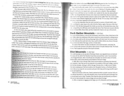
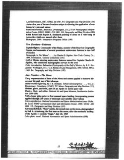
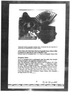
UNITED STATES GEOGRAPHIC BOARD
641,
the name changes of "the dominant landscape features of the Monument,"
See work card
Champlain
Including the importance of recognizing the indigenous peoples that used
Thing
Mauntain
Located
of
the Penobscot River for seasonal canoe passage to Mount Desert Island. 10
East
Sieur Monts Natl Monument, Mount Desert
Maine The mosteastern Mtn. of the Island:
The fundamental rationale that runs through scores of documents spanning
Names
Authorities
more than a decade is stated in a memorandum the USBGN received from
Newport Mtn
Designation since 1855-date unknown
the Superintendent: the renaming of "its noble granite masses
have
Champlain
Discoverer of Mount Desert Island and who named the let
become true historic documents that will record forever to succeeding
Name proposed by Geo, B. Dorr, Custodian of the Net'l Monument
representing the "Wild Gardens of Acadia supported by the
generations the human background [of] the Park."
Secy of the Interior, Bureau of Nat'l Parks many Assoeil
Local usage
ations, and distinguished men, to commemorate early history
Following the 1919 elevation of the Monument to its new status
Newport Mtn
and to honor France for her part in the present war.
as Lafayette National Park, additional geographic name changes were
proposed to the USBGN. By 1929 approvals had been secured to rename
Recommendation of Executive Committee
Submitted by
Geo. B. Dorr Int Dept
Champlain
I'm of fourteen mountains-and Island maps reflected these changes. To
Date
Sept 15th 1918
this day, critics claim that Dorr's decisions were arbitrary. 12 As new maps
This card prepared by
were drawn and distributed, it is likely that there was private grumbling,
but there is no evidence that such grumblings were aired publicly.
Official request form to standardize the name of Champlain Mountain, October 2, 1918, the
In 1920, a supportive position was expressed for the decision-making
mountain was originally named for an English mariner, Christopher Newport. Courtesy of
Secretary, U.S. Board on Geographic Names
process in the naming of trails. In the leading publication of mountaineering
In the eastern United States, Appalachia Mountain Club trail maker and
Harvard College at sixteen-in the class of 1874, the year after fellow Trust
classicist Paul R. Jenks published remarks on "The Naming of Trails" that
Charles W. Eliot assumed the presidency. Dorr concentrated his studies in
overlap and extend Dorr's line of thinking. "Names should be given to trails
classical and modern languages, history and, despite a stammer, he showlil
for a single, definite, necessary reason, to-wit, for identification. This is the
equal ardor for elocution, oratory, and rhetoric. Before he was thirty, he live
historical reason for all names, as properly applied." Furthermore, Jenks
in Europe for six years where his linguistic skills were well honed by current
argued that in the interests of proper nomenclature and "for the edification
usage. One product of this worldly education was Dorr's development of III
of future generations," names should be adopted "only after consideration
exceptional sensitivity to both "dead tongues" and the French language. HI
and action by a responsible committee."13
understanding of French pioneers in the New World was in part based on the
Dorr's superiors were consulted before action was taken and the
"romantic" historical writings of his childhood neighbor on Jamaica Pond
Superintendent himself solicited endorsements from educational,
the nineteenth-century historian Francis Parkman. Both men were awain
historical, and conservation colleagues, including the weighty national
that language is a medium that divides as easily as it unites but in the end
support of the Trustees of Public Reservations President Charles W. Eliot.
the historian sits in judgment of the performance of men and their culture
Town records, village improvement society minutes, the Bar Harbor Times,
In some instances when a mountain carried a name with historia
and the USBGN documents provide no evidence of local protests. Until
associations, Dorr succeeded in convincing the USBGN that another name
the onset of the Great Depression, the renaming of mountains was not
should be substituted. Originally named for an honored English marinti
Interpreted publicly as a conflict between federal and local power.
Christopher Newport, this mountain on the eastern side of the Island
To the contrary, at the annual Bar Harbor town meeting in March 1919,
thus became Champlain. Green Mountain was referred anew as Cadilla
il unanimous motion was passed: "That [the] inhabitants of Bar Harbor
"Picket as Huguenot Head, Dry as Flying Squadron, Jordan as Penobace
extend [their] most appreciative thanks to George Bucknam Dorr for his
Brown as Norumbega, Little Brown as Parkman, Robinson as Acadh
theless, persistent, intelligent work, carried on under the most adverse
and Dog as St. Sauveur. In il six-page September 15, 1918 letter to the
dicumstances. He has overcome obstucles that no other friend of the
in promoting the Black House (known today as Woodlawn Museum) as a
premiere Maine tourist attraction.
But departing from this goal, he submitted a letter to the editor of
the Bar Harbor Times. on January 2, 1931-without sanction from the
officers of the Trustees of Public Reservations-reporting that at the
Trustees' August 28, 1930 annual meeting he had entered a motion that
at the next annual meeting the Trustees declare themselves in favor of
the "well known [mountain] "names." Hale confidently announced in the
paper that an informal Trustees poll showed that twenty-eight of thirty-six
favored the names in use before the USBGN name-change approvals. Yet
fellow Trustee Lincoln Cromwell had written to Dorr's attorney Serenus
B. Rodick several months earlier that he had "heard very little objection to
the names except from a small group which has opposed consistently all
of the Rockefeller developments."^s This implied that the land acquisition
and carriage road construction program of John D. Rockefeller Jr., an ally
of Mr. Dorr, could be at the heart of the matter.
Attorney Hale asked the Times to poll its readers. Over the next several
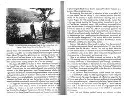
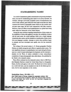
George B. Dorr and his mountain re-naming ally Charles W. Eliot at Jordan Pond, 1922.
Courtesy of Acadia National Park and the National Park Service
weeks ballots were cast and the tally was overwhelming: 150 votes for the
old names, three for the new. Lest Mr. Dorr have any doubt about the
[Island] would have commanded the courage to overcome, and has finally
position of those nearest and dearest to him, each voter name and preference
secured for us and for our posterity the Lafayette National park on Mount
was published. Letters to the Times editor emphasized the significance of
Desert Island. We regard the achievement as a crowning event in a life, NO
place names due to their ancestry and emotional power.
much of which has been devoted to the interest of Bar Harbor."
This
There is no evidence that Hale re-entered his motion at the 1931
public tribute resonates with the basic concept key to Dorr's conservation
CTPR meeting; moreover, the controversy was apparently not considered
ethos and mountain naming practice: "for us and our posterity."
sufficiently newsworthy to receive additional press coverage. Nonetheless,
On August 29, 1929 the Trustees of Public Reservations conveyed "to
I lale wrote to the USBGN on September 30, 1932 requesting relevant
the United States all lands owned by the Corporation on Mount Dexor)
documentation of Dorr's requests for these "darn-fool names." Hale claims
Island." Over the next few years additional parcels were accepted and then
10 "love [Dorr] for the great services which he has done but in this matter
conveyed to the federal government. Some Trustees wondered whether the
of names, I am his energetic enemy."
organization had a future. Many founding members were either deceased or
So too, renowned naval historian and Trustee Samuel Eliot Morison
no longer involved, and new members-like Richard W. Hale and Samul
Whole to the USBGN on May 27, 1933 requesting that the names used prior
Eliot Morison-were emphasizing the museum potential of the Black How
to 1917 be restored. He argued that signage still reflected old usage, that the
Moreover, the Trustee who had been the key figure in land acquisition WIII
old names were reflected in American literature, and that the new names had
now a federal administrator with considerable influence in the nation's capto
not been popularly accepted. Morison concluded that if we can change the
The trigger for the ensuing controversy did not lie with local residen
name of the park to "the old French name of the region," ("l'Acadie") we can
It was someone "from away," a partner in the Boston law firm of Hall
Irvert back to the old mountain names as well. Lacking support from the
and Dorr (no relation to the park superintendent), one of the largest
National Park Service, no action was taken by the USBGN in response to
law firms in New England. That attorney, Richard W, Hale, was the first
these requests.
chairman of the Black House Committee and IN il Trustee, his priority Will
Both Hale and Morison involded making any reference 10 fellow
Trustee Dorr-as did the letters to
evolution of names and risked disaffection from his contemporaries. It
the Bar Harbor Times. Nor is there
was his judgment that over successive generations the new names would
any evidence indicating that the
provide lasting significance to the international body of visitors that would
new name opponents collaborated.
travel the roadways around-or traverse the trails of-the mountains of
Superintendent Dorr did not respond
Acadia National Park. More so than any national park superintendent of
publicly and his personal reaction to
his day, Dorr brought to his position in the new National Park Service a
the Trustees and public disapproval is
set of scholarly-imbued leadership skills remarkable by any standard. The
not known. Moreover, the controversy
National Park Service supported his efforts to locate historical precedent for
was confined to Mount Desert Island;
natural features and to abide by the decisions of the USBGN. Cartographers
comments on the matter do not
placed new names on maps, though the old names still remained on earlier
appear to have reached the county,
maps and in the minds of their loyalists.
state, or national levels and the
Dorr's effort was motivated by his love of place, his passionate desire
controversy does not compare with
to substitute selected points of conventional reference with those having
the magnitude of the automobile ban
worthy historical associations. While more often successful than not, Dorr
il decade earlier. 17
was "a party of one" petitioning for these changes. He took this risk not
Mr. Dorr applied his scholarly
for visitor amusement or to provoke local dismay when a place name
expertise in referencing a more
Richard W. Hale, Dorr's "energetic enemy" in
ancient European lineage than what
the mountain naming controversy. Courtesy of
disappeared from the most recent map. Instead, through the administrative
WilmerHale, Boston, Massachusetts
processes available to him, Dorr provided the intellectual underpinnings
WITH customary for the inhabitants of
10 ensure that the seascapes, landscapes, and "noble granite masses" of the
Mount Descri Island. Applying his well traveled historical and linguistic
park would be perpetuated.
standards, Dorr found the indigenous and rusticator culture inadequate
(1) the task ill hand, He proceeded in this nomenclature revision without
Notes
public discussion and without formal input from the Trustees of Public
I
Renervations. I disstanding as a federal officer lent weight to his justifications,
In an email of January 7, 2014, Island historian Jack Russell drew my attention to the varied
activities of the explorer during the several days that Champlain spent in Pemetic waters. See David
but nome may fault Mr. Dorr for not seeking public input, for not bowing
I
lackett Fischer, Champlain's Dream (New York: Simon & Schuster, 2008), 174-77.
before the collective weight of his fellow Trustees.
I larold E. L. Prins & Bunny McBride, Asticou's Island Domain: Wabanaki Peoples at Mount Desert
I Hstorians and anthropologists could interpret Dorr's renaming
Wand 1500-2000 (Boston: Northeast Region Ethnography Program, National Park Service, 2007),
vol. 1.
of landscape features as an act of dispossession or a form of cultural
In 2003, Roger Payne, USBGN Executive Secretary, provided me with more than a hundred pages
Imperialism." My goal here is not to challenge such an interpretation but to
of copies of official documents regarding MDI place name changes initiated by Mr. Dorr.
I
provide the background of an Island controversy that took place when the
Dorr, Memoirs, March 29, 1933. Dorr Papers, Bar Harbor Historical Society; G.B. Dorr to
cultural implications of a strengthening federal presence on Mount Desert
USBGN, September 15, 1918. USBGN Archives. Reston, Virginia. See also Henry A. Raup,
"liy, Corkscrew and Whaleback: Descriptive Terms in the Placenames of Mount Desert Island,"
presented unique challenges and opportunities for all who resided here,
I Thobacco 6 (2004): 41-53.
Noteworthy is the fact that eight days after Mr. Dorr's death on August G,
Sources for the quotations in this paragraph are as follows: Dorr to Lincoln Cromwell, February
1944, fellow Trustee Judge John A. Peters offered a motion at the Trusteer
11, 1917; Dorr to C.W. Eliot, May 7, 1919; C.W. Eliot to Dorr, May 9, 1919. Charles W. Eliot
Papers, box 95, Harvard University Archives. Also, G.B. Dorr to Stephen T. Mather, December
annual meeting that was greeted with "enthusiasm and unanimously
10, 1917. National Archives and Records Administration. CP. RG79. CCF. Acadia. Misc. Reports.
approved
Namely, that the mountain situated between Champlain and
14 Judith S. Goldstein, Crossing Lines: Histories of. Jews and Gentiles in Three Communities (New York:
Cadillac mountains formerly known IIN Dry Mountain be renamed Dorn
William Morrow, 1992), 185, An earlier and more limited version of this article appeared in "The
Mountain Naming Controversy and the Mission of the "Trustees," Woodlawn Museum Newsletter 2
Mountain. Within ten months, the change Will approved by the USBGN,1
(2005): 3. My forthcoming mindy entitled the Making of Acadia National Park provides the larger
Dorr was il conservation pioneer who took il philosophic view on the
context for the claims herein.
7 (Paraphrasing the January 26, 2007 New York Times review by Charles Isherwood of Brian Friel's
1981 play, Translations.)
8 See "Francis Parkman on Acadia." Accessed January 2, 2012.www.wquercus.com/acadie/parkmantg
htm. I am also indebted to Mount Desert Island Historical Society Executive Director Tim Garrity
for suggesting that this theme is theatrically developed in the aforementioned play, Translations.
9
Margie Coffin Brown, Jim Vekasi, and Olmstead Center for Landscape Preservation, et also
Pathmakers: Cultural Landscape Report for the Historic Hiking Trail System of Mount Desert Island
(Boston: National Park Service & Olmsted Center for Landscape Preservation, 2006), vol. 1, 98,
10 The USBGN Archives also contain a nine-page April 9, 1919 letter explaining the cultural
importance of recognizing the name "Penobscot" for the northern and southern portions than
known as Sargent and Jordan mountains.
11 "Memorandum," March 6, 1931, Mount Desert Island files, UBBGN Archives.
12 In response to my editorial in The Mount Desert Islander of June 23, 2005, see Mark A. Preston's
July 21, 2005 letter to the paper's editor claiming that Dorr "didn't understand or seem to care that
the original names reflect [the] character of the early days of Mount Desert."
13 Paul R. Jenks, "The Naming of Trails," Appalachia 15 (1920),182-85.
14 Bar Harbor Times, March 8, 1919.
15
Trustees Lincoln Cromwell, L. B. Deasy, Charles W. Eliot, Samuel A. Eliot, William Drapa
Lewis, William O. Sawtelle, and F. J. Stimson were opposed to Hale's resolution, according to the
front-page article in the Bar Harbor Times of January 9, 1931.
16 September 11, 1930, Hancock County Trustees of Public Reservations Archives, I.2.c.1/2.1.A.S,
See also Bar Harbor Times, January 28, 1931.
17 See Bill Horner, M.D., "From Horses to Horsepower: Mount Desert Island's Ten-Year War for the
Automobile," Chebacco 14 (2013): 86-106.
18 I am indebted to Harold E. L. Prins for referencing this contention. See J.B. Harley, "New England
Cartography and the Native Americans," in American Beginnings: Exploration, Culture and Cartography
in the Land of Norumbega, eds. Emerson W. Baker, Edwin A. Churchill, Richard D'Abate, Kristine
Jones, Victor A. Konrad, Harald E. L. Prins (Lincoln: University of Nebraska Press, 1994), 287-31 S
email from Harald Prins, December 15, 2013; Harald E. L. Prins & Bunny McBride, "Asticou's Flord
or Somes Sound? Mythistory of Wabanaki Dispossession," Chebacco 12 (2011): 41-61.
19 Approved June 15, 1945. "Dorr Mountain. Case Study # 641.5," Mount Desert Island film
USBGN Archives.
20 I am indebted to Acadia National Park Ranger Maureen Fournier for this phraseology and harp
critical comments on a draft of this article.
MOUNT DESERT ISLAND
HISTORICAL SOCIETY
Executive Director
Timothy F. Garrity
Board of Directors
William Horner, M.D.
Dru Colbert
President
hebac
Nathaniel R. Fenton
Daniel Poteet
The Magazine of
Vice President
Carroll Fernald
the Mount Desert Island
Gerard Vasisko
Susan Lerner
Historical Society
Secretary
Sandy McFarland
Andrew Griffiths
Treasurer
Samuel McGee
Ralph Stanley
Howard D. Monroe
Volume XV
President Emeritus
Robert R. Pyle
2014
Marion Stanley
Honorary Member
Rosamond Rea
Raney Bench
Raymond Strout
Mount Desert, Maine
Ann G. Benson
Genie Thorndike
P. Hamilton Clark
Cornelia Perkins Zinsser
This publication is made possible by the genero
Administrative/Creative Assistant
Virginia Mellen
Peter and Sofia Blanchard
and
Chebacco Editor: Emily M. Beck
George and Nancy Putnam
Images design: Genie Thorndike
The Naming of Trails
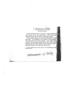
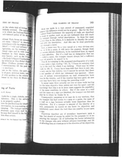
By PAUL R. JENKS
NAMES should be given to trails for a single, definite, neces,
sary reason, to-wit, for identification. This is the universal
historical reason for all names, as properly applied.
It is scarcely necessary to state the justifications for identify
ing trails. It is desirable in conversation, in map-making, etc.
but much more so in actual tramping. The tramper naturally
needs to know beyond peradventure upon what trail he is
starting and upon what trail he may find himself in the forest
Objectives alone do not make him thus certain.
1 A paper presented at the annual meeting of the New England Trail Conference
January 22, 1921.
APPALACHIA
15
(1920)
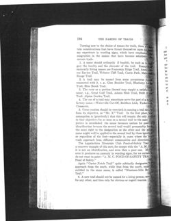
[ING OF TRAILS
THE NAMING OF TRAILS
183
at the whole field of biology,
imilarly
Were our trails in a vast stretch of unmapped, unguided
covered.
The
in
which
opportuni
e
the
National
country the difference would not be SO great. But for the New
Park
;egland Trail Conference the majority of trails are described
bad-visioned policy of its director
maps or guides; such as are not indicated thus will reach
the tramper through verbal descriptions. In these few cases
ational Park forms an exceeding
less than in the others, it is desirable to identify the actual
in's
term
"déserts"
in
description
with the description. And this can be done practically
accordance with the original signifi
bited" wild and solitary;"
niy through a name
Now, a name may be a very casual or a very obvious one;
Vegetation, on the contrary, gro
NO it be a name, it will serve the purpose, though there
tional vigor and in wide ranged
certain definite desiderata, to be mentioned later, in regard
bundant in their season, amon
'1) their selection. But if a trail has no designation that can
lous beauty. such as the Fringer
called a name, the tramper cannot always feel a sufficient
the Lady's Slipper (Cypripedium)
onse of security in regard to it.
ng Arbutus or May-flower (Epigea
Thus if, in tramping to the supposed starting-point of a trail,
illium (Trillium pictum)-all, for
I come upon a sign reading "Mt. X,' I have no certainty that
f extermination till the park was
this is the trail for which I am looking. There may be other
)
a sanctuary.
rails to Mt. X. I may have been told that there is only one,
ant to the visitor, the park po
or only one in this vicinity; but I cannot be certain that there
ly of pure, delicious water, issuin
is not another of which my informant was ignorant. More-
st wild gardens in the vicinity
over, if certain over-enthusiasts on trail construction have
honor to the Sieur de Monts and
been in the vicinity, and if the weather has been good, six new
ones may have been cut during the preceding week!
In many cases there actually are two or more trails leaving
for the same objective from points not very far apart: and the
ing of Trails
knowledge that this is SO in some cases suggests the possibility
of the same condition in others. But if the name of a trail
UL R. JENKS
and the name on a sign are identical, the tramper can feel sure
that he is where he thinks he is.
trails for a single, definite, neces-
Consequently, assuming as we may do in our territory, that
tification. This is the universal
the tramper has had access to a map or a guide, the name of
S, as properly applied.
a trail on a sign becomes actually more important than its
tate the justifications for identify
objectives. For if a tramper is assured of the identity of a
conversation, in map-making, etc.
trail, presumably he knows or can know its objectives and
ramping. The tramper naturally
indefinitely more about the trail than can possibly be put upon
dventure upon what trail he is
a sign.
he may find himself in the forest
Objectives therefore are of secondary importance upon a
him thus certain.
sign, but should of course be added for the purposes (1) of re-
assuring the tramper; (2) of indicating the barest information
ecting of the New England Trail Conference
to the tramper who goes without advance knowledge; and (3)
of affording data at crossings as to the direction of the objectives.
184
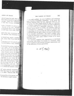
THE NAMING OF TRAILS
Turning now to the choice of names for trails, there are
tain considerations that have thrust themselves upon melim
my experience in wording signs, which have emphasized
congruities in the names that have become established for
certain trails.
1. A name should ordinarily if feasible, be such as to sug
gest the locality and the character of the trail. Examples
eminently fitting names are Franconia Ridge Trail, Ammonbo
be
suc Ravine Trail, Webster Cliff Trail, Castle Path, Mahoosue
by
Range Trail.
an
2. A trail may be named from some conspicuous feature
bu
connected with it, e. g., Glen Boulder Trail, Blueberry Ledge
to
Trail, Blue Brook Trail.
pc
3. The route or a portion thereof may supply a satisfactory
th
name, e.g., Great Gulf Trail, Adams Slide Trail, Swift River
Trail, Alpine Garden Trail.
4. The use of a trail may sometimes serve for part of a satis
factory name.-Waterville Cut-Off, Baldface Link, Tuckerman
Crossover.
5. Great caution should be exercised in naming a trail simply
from its objective, as "Mt. X" Trail. In the first place, the
assumption is (practically) that this will remain the only trail
to that objective; for as soon as a second trail to the same ob
jective is established the name becomes useless for positive
identification because the second trail would presumably have
the same right to the designation as the other and the same
name might well be applied to the second trail by those ignorant
or regardless of the first-especially in cases where the two
trails approach from different communities and directions.
The Appalachian Mountain Club Pond-of-Safety Trail is
a concrete example of this sort; for except with the "A. M. or
it is not an identification, and even then a poor one. More-
over it produces an anomaly in wording signs; for we certainly
do not want to paint: "A. M. C. POND-OF-SAFETY TRAIL
Pond of Safety."
Again "Carter Notch Trail" quite arbitarily designates the
approach from the south, while that from the north, equally
entitled to the same name, is called "Nineteen-Mile Brook
Trail."
6. A new trail should not be named for a living person; rarely
for any other, and then only for obvious or cogent reasons.
AMING OF TRAILS
THE NAMING OF TRAILS
185
oice of names for trails, there are
As trails multiply, the use of arbitrary and extraneous
have thrust themselves upon me from
T. becomes increasingly undesirable. A few names like
ng signs, which have emphasized
is that have become established for
names American Institute Path, Air Line, Algonquin Trail, etc., are
not serious, but their number should be kept at a minimum.
Finally, a name should be adopted only after consideration
narily if feasible, be such as to sug.
and S. formal action by a responsible committee. Freak and
character of the trail. Examples of
.'°C Franconia Ridge Trail, Ammonoo-
facetious names should be avoided, and probably would not
sanctioned by a committee. It cannot be conceded that
er C'liff Trail, Castle Path, Mahoosu
by be supervising or even by doing the work of opening a trail,
an individual gains the right to name it; he may be a fine axeman
umed from some conspicuous featur
an execrable nomenclator! One head is unlikely either
Glen Boulder Trail, Blueberry Ledge
but foresee all objections to a proposed name, or to sense all the
10 possibilities for a good name-which is rather to be chosen
on thereof may supply a satisfactory
rail, Adams Slide Trail, Swift River
than great riches.
It is therefore suggested that organizations or individuals
il.
constructing trails submit the naming to a committee, either
I sometimes serve for part of a satis
general or special, in the interests of proper nomenclature and
Cut-Off, Baldface Link, Tuckerman
for the edification of future generations.
be exercised in naming a trail simply
t. X" Trail. In the first place, the
that this will remain the only trail
V. 15(1920)
on as a second trail to the same ob-
name becomes useless for positive
second trail would presumably have
gnation as the other and the same
to the second trail by those ignorant
-especially in cases where the two
rent communities and directions.
tain Club Pond-of-Safety Trail is
sort; for except with the "A. M. C.I
and even then a poor one. More-
I in wording signs; for we certainly
I. C. POND-OF-SAFETY TRAIL
ail" quite arbitarily designates the
while that from the north, equally
3, is called "Nineteen-Mile Brook
be named for a living person; rarely
for obvious or cogent reasons.
Fourteen Thousand Feet
A History of the Naming and Early Ascents
of the High Colorado Peaks
SECOND EDITION
By
JOHN L.JEROME HART
Member of
THE ALPINE CLUB
THE AMERICAN ALPINE CLUB
THE COLORADO MOUNTAIN CLUB
1972 Reprint of the 1931 Second Edition
Published by The Colorado Mountain Club
Denver, Colorado
PREFACE
The first edition of the portion of this work dealing with the
naming and early ascents of the high Colorado peaks was pub-
lished in April, 1925, by The Colorado Mountain Club. For their
assistance in the preparation of that edition I am very grateful
to Messrs. Ellsworth Bethel, Carl Blaurock, Albert R. Elling-
wood, Richard H. Hart, Edmund B. Rogers, James Grafton
Rogers, Dudley T. Smith, and Roger W. Toll, and Miss Blanche
Curry. Of particular use were the list of 14,000 foot peaks made
in 1914 by Mr. Ellsworth Bethel and Mr. James Grafton Rogers,
and "Mountain Peaks of Colorado" published by Mr. Roger W.
Toll in 1923, being a list of all the named summits of Colorado.
The index to the first edition was prepared by Miss Lucretia
Vaile, and this index has been revised for the second edition by
Mrs. Lewis E. Perkins. The map was prepared by Mr. Frank
Yale and revised for this edition by Mr. Alan B. Fisher. I am
indebted to Messrs. William R. Driver, Alan B. Fisher, George
H. Harvey, Jr., Merritt H. Perkins, and Tom Thiedemann, Miss
Blanche Curry, Miss Grace Harvey, and Mrs. Hugh Kingery for
their assistance with the present edition.
Because of the large amount of new material available, the
section on the names of the Mt. Evans group and Crestone group
and the section on the early ascents of Longs Peak, Grays Peak,
and Blanca Peak have been rewritten. The following accounts
have been considerably enlarged,-the names for the main range
of the Rockies, Grays and Torreys, the Mosquito Range and its
peaks, the names of the Sawatch Range, the Indian as an Alpinist,
and the early ascents of Pikes Peak. New material has been
added throughout, as can be seen from the fact that two hundred
authorities are referred to by footnotes in the second edition
instead of one hundred twenty-two in the first. I am indebted to
the persons who have communicated new facts to me since the
publication of the first edition and hope that other persons will
volunteer further information. New mountains added to the list
of 14,000 foot peaks since the first edition are Little Bear Mt., El
Diente, Mount Oxford, and Tabeguache Peak. An account of the
name and early ascents of the Mount of the Holy Cross has been
included.
The United States Geological Survey has just issued part of the
Snowmass quadrangle, showing Snowmass Mountain as 14,077
feet, or 107 feet higher than the figure given on the Hayden Atlas.
This corroborates the statement in the text that Hayden's heights
in this region are all over a hundred feet too low, and makes it
probable that Capitol Peak is about 14,100 feet in height.
Hiding in the Archives
By Peter G. Lewis & James W. Thomas
A letter arrived at the American Geographical Society last year. "I must have
access to your secret files. It is imperative that I know what transpired between Richard
Byrd and Isaiah Bowman on December 11, 1930. The confession must be made public."
According to Peter G. Lewis, the Archivist at the AGS, there was, alas, no secret file in
the archives holding the truth behind Byrd's Polar flight. Nor does it hold the secret to
the location of Atlantis or the meaning of Stonehenge. The archives simply hold a
fascinating, if less explosive, gathering of material from the Society's past. There was no
letter of admission from Byrd confessing to flying his plane home for Christmas instead
of heading for the North Pole. There are, however, folders full of letters between Byrd
and Bowman. They were friends as well as professional colleagues and Bowman long
championed Byrd's explorations. If you don't mind tight quarters and a bit of dust in the
Archive Room, you can go through cabinets of correspondence from Bowman, who was
Director of the American Geographical Society from 1915 to 1935. Reading a letter
signed by such a figure as Bowman or Byrd or many more does feel like eavesdropping
on history.
Started with the Society's founding in 1851, the archives are first and foremost a
comprehensive institutional record of the AGS. The administrative and editorial
correspondence and the Society's financial records go back 150 years. (AGS will be 150
on 9 October - John Lennon's birthday.) Now some of this material is scant and some if
it is voluminous but chances are good that if it happened within the orbit of the
American Geographical Society, there is at least note of it in the archives. We even have
a flag carried by Richard Byrd on his November 1929 flight to the South Pole. No
secrets there.
There are a lot of personal items, including a stunning array of diaries and
notebooks from explorers. For example, there is Hudson Stuck's diary of his ascent of
Mount Denali. The University of Alaska just ordered a copy of it for their files. The
archives also have Gerald McKiernan's diary of five year's travel through southern
Africa in the 1870's; the Fanning Collection comprising notebooks and correspondence
from Edmund Fanning's exploration of the South Seas from 1799 to 1840; John F.
Steward's diary of the Second Powell Colorado River Expedition; and correspondence
regarding the scientific results of the Challenger Expedition of 1872-76.
As the Society started partly in response to the searches for the lost Franklin
Expedition, and further polar exploration, not surprisingly the AGS archives contain a
wealth of polar materials. A sampling includes notebooks, diaries and original
manuscripts of Sir George Hubert Wilkins; the log of Lincoln Ellsworth's Graf Zeppelin
flight to the Arctic in 1931; memorabilia from Robert E. Peary, who was AGS President
on his North Pole trek just before his successful one that got to (or really near) the Pole;
diaries of Vilhajalmar Stefanson; and - photographically - original materials from Louise
Arner Boyd and her expeditions to Greenland.
There is also correspondence from the likes of David Livingston, John Wesley
Powell, Theodore Roosevelt, Franklin Roosevelt, Frederick Jackson Turner, Alfred
Wallace, Charles Francis Adams, and Robert Falcon Scott.
And a propeller from Charles Lindbergh. He was a Fellow of AGS and, after he
had made several flights in 1931 in his Lockheed Orion to prove the Great Circle route to
Japan was viable, as the story goes, he drove up to the AGS building, then at 156th Street
and Broadway, with a propeller sticking out of the back seat of his convertible, walked in
and asked, "Hey, do you want a souvenir?" We still have it.
There are, as well, records relating to government contracts carried out by the
Society, ranging from the Map of the Arctic Region, done for the National
Oceanographic and Atmospheric Administration, to country handbooks written during
World War II, to the materials relating to the Inquiry of World War I. Colonel Edward
House, President Woodrow Wilson's chief adviser, established the Inquiry to amass
information needed for Wilson's approach to the post-war world. The information
gathered was ultimately shipped to France for the Versailles Peace Conference. The
Inquiry was based at the AGS because of the superior library , map collection and
cartographic facilities.
This geographical connection led Secretary of State Robert Lansing in 1919 to ask
for Bowman and the Society's help with a border dispute between Guatemala and
Honduras. Bowman recommended an "Economic Survey" of the disputed territory. The
dispute was finally settled in 1933, but, in the meanwhile, AGS took this impetus to start
the Millionth Map Series - one inch to one million inches - from Mexico and the
Caribbean down to Tierra del Fuego. The 104 sheets were produced between 1922 and
1945 and they still have an impact on border disputes. They were used as authoritative
sources to settle disputes with visits to the AGS archives in 1925, 1929, 1932, 1933 In
the early 90's, the office would get calls from the Chilean and Argentinian consulates in
New York asking for copies of the Isla Wellington-Santa Cruz materials. There was no
official word on whether or not they ever settled this. And in October 1998 Peru and
Ecuador singed a peace accord on a border dispute after Peruvian diplomats consulted the
Archives of the AGS over a three-year period. The Archives are not irrelevant to today's
world.
Just last December, we brought out the Fliers' and Explorers' Globe from the
Archives. This Globe was given to the Society in 1929 by John H. Finley, President of
the AGS from 1925 through 1934, and later Editor-in-Chief of The New York Times.
Finley had a habit of inviting outstanding fliers and explorers to draw their routes on the
Globe and then sign their names. After Finley presented the Globe to the Society, AGS
continued the tradition. With over sixty names, the Globe is a unique collection of
priceless graffiti. Some of the names on the Globe might be recognizable: Roald
Amundsen, William Beebe, Louise Boyd, Richard Byrd, Amelia Earhart, Lincoln
Ellsworth, John Glenn, Mathhew Hensen, Edmund Hillary, Charles Lindbergh, Fridtjof
Nansen, Robert Peary, Wiley Post, and, the last to sign before the year 2000, Anders,
Borman and Lovell from the first Apollo flight around the Moon.
The American Geographical Society updated the archival Globe on 11 December
2000 with six new signers: Bertrand Piccard, Brian Jones, Walter Pittman, William Ryan,
Neil Armstrong, and Don Walsh. Brian Jones and Bertrand Piccard were the first fliers
ever to circumnavigate the earth by balloon in 1999. Walter Pittman and William Ryan
explored the Black Sea floor and discovered a massive flood that occurred there about
7,500 years ago, possibly explaining the source of the story of Noah's Flood. William
Ryan and colleagues explored the Mediterranean Sea floor and discovered a massive
desiccation and then inundation that occurred there about five million years ago. Neil
Armstrong was the first man to step on the Moon in 1969. Don Walsh, along with
Jacques Piccard, Bertrand Piccard's father, descended to the deepest part of the ocean, the
Challenger Deep in the Marianas Trench in 1960 in the bathyscaphe Trieste.
Besides the famous names from the Archives, a wide variety of people, from
scholars to the simply curious have made good use of the Archives. Just call us and ask
for Peter Lewis, our Archivist, if you need to poke around. There is more. Oh, did I
mention the Inuit stone axe head and, as the label says, "the matchbox with its contents
left intact in a cabin built by Roald Amundsen on Mt. Betty, Queen Maud Mountains,
Antarctica, on his way home from the Discovery of the South Pole in December 1991"?
But then they're no secret, merely further examples of the scope of the Archives befitting
a scholarly society that first saw the light of day when Millard Fillmore was president,
who himself, indeed, is a well-kept secret.
"Hiding in the Archives" was presented at the:
Annual Meeting of the Association of American Geographers - 3/2/01
Rendezvous Room, New York Hilton
New York, New York
AGS - Continuity and Change (Sponsored by AAG and Association History Committee)
Organizer:
Christopher Baruth, University of Wisconsin-Milwaukee
Panelists:
Mary Lynne Bird, American Geographical Society
Miklos Pinther, United Nations
Geoffrey Martin, Southern Connecticut State University
James W. Thomas, American Geographical Society
Christopher Baruth, University of Wisconsin-Milwaukee
The Arthur Holzheimer Lecture Series: Maps and America - 5/18/01
American Geographical Society Collection, Golda Meier Library
University of Wisconsin-Milwaukee
Milwaukee, Wisconsin
PROGRAM
Welcome
John Wanat, Provost & Vice Chancellor, UWM
Peter Watson-Boone, Director, Golda Meier Library
Christopher Baruth, Curator, AGS Collection
AGS Exploration: A Century on the Frontiers
Jerome E. Dobson, Oak Ridge National Laboratory and
Director of Exploration, AGS
The AGS Cartographic Collections
Dr. Christopher Baruth, Curator, AGS Collection
The History of Cartography at the American Geographical Society
Miklos Pinther, United Nations (Retired)
The Archives of the American Geographical Society
James Thomas, Programs Coordinator,
American Geographical Society
The Inquiry, the Paris Peace Conference and the AGS
Geoffrey Martin, Distinguished Professor Emeritus,
Southern Connecticut State University
AGS: Continuity and Change
Mary Lynne Bird, Executive Director
American Geographical Society
Maps and Their Makers: A Sense of Where We Are
John Noble Wilford, Senior Science Correspondent,
New York Times and AGS Councilor
Transparencies used in 18 May 2001 presentation follow:
Letters:
1859 - Dr. David Livingstone, River Zambezi, Eastern Africa, postmarked Providence RI
report on conditions in Africa
1862 - William H. Seward, Secretary of State
Society resolution submitted for the consideration of the President
1873 - Dr. Henry [sic] Schliemann, archaeologist, Athens
excavations of Troy, with photograph
1874 - General William T. Sherman, Headquarters Army of the United States
visit to New York
1876 - John Wesley Powell, Department of the Interior
visit to New York
1903 - Frederick A. Cook, Brooklyn
proposal to President R.A. Peary and Society for expedition to Mount McKinley
1903 - Robert E. Peary, President, AGS
in favor of lending a helping hand when its reasonable
1906 - Robert Falcon Scott, polar explorer
thank you for the AGS Cullum Geographical Medal
1909 - Secretary Bridgman, Peary Arctic Club telegram
North Pole discovered April sixth 1909 by Peary Arctic Club Expedition
1918 - Theodore Roosevelt, New York
regrets for missing presentation of Cullum Medal to Professor Newell
1927 - T.E. Shaw (T.E. Lawrence, aka Lawrence of Arabia)
regrets for refusal to review books by Alois Musil on Arabia
1928 - George Hubert Wilkins, Detroit News-Wilkins Expedition to the Arctic
to Isaiah Bowman listing code words for radio broadcast
1930 - Richard Byrd, Little America, Antarctica, radiogram
thanks to John Finley and AGS for receiving the Livingstone Medal
1931 - Charles Lindbergh
list of English and corresponding Russian words for emergencies
1931 - Rudyard Kipling, Burwash, Sussex, England
to Isaiah Bowman thanking him for The Pioneer Fringe
1932 - Franklin D. Roosevelt, Executive Mansion, Albany, New York
resignation from AGS Council because of new job offer
unused letters
1864 - Charles Francis Adams, U.S. Ambassador to Britain, to Charles Waddell
1881 - Frederick Schwatka, to Robert Curren
1886 - Alfred Wallace, Quincy Hotel, to Albert Browne
1897 - Franz Boas, American Museum of Natural History, to Charles Daly
1916 - Roald Amundsen, Consulate of Norway, Chicago, to Isaiah Bowman
1919 - Hudson Stuck, Grace Church, Providence, Rhode Island, to John Greenough
1923 - William Beebe, Williams Galapagos Expedition, to Isaiah Bowman
1930 - Charles Lindbergh, Guggenheim Fund for Aeronautics, to Gladys Wrigley
1931 - Vilhjalmur Stefansson, New York, to Isaiah Bowman
1939 - Louise A. Boyd, Ritz-Carlton Hotel, to John K. Wright
1948 - Finn Ronne, Department of Commerce, to John K. Wright
Illustrations:
undated
Nathaniel Palmer painting in AGS library
1971 - first day cover 10th anniversary of Antarctic Treaty
The First Sighting of the Antarctic Mainland November 16, 1820
Portrait Courtesy of American Geographical Society
1855 - Memorial to the Senate and House of Representatives of the United States
supporting relief for Kane's 1853 expedition in search Sir John Franklin
1862 - Elisha Kent Kane engraving
1869 - engraving of Charles P. Daly, Chief Judge of the Common Pleas, AGS President
1870s John Wesley Powell photograph with Paiute Indian
1892 - Albert Operti painting, Last Franklin Search 1879
Lieutenant Frederick Schwatka and W.H. Gilder
1904 - Eighth International Congress photograph of R.A. Peary, President IGC & AGS
1916 - The Three Polar Stars, Bellevue Stratford Hotel, (Chicago ?)
Captain Roald Amundsen, Sir Ernest Shackelton, Rear Admiral Robert Peary
1920 - New York Times, 23 Educators Taking Vast Data, Go With Wilson
American Geographical Society Announces Personnel
"Inquiry" Collated Facts Compiled by Staff of 150 Persons in U.S. and Abroad
1926 - Chart of Route Flown by Richard E. Byrd to the North Pole
autographed For Dr. Bowman
1931 - American flag carried over South Pole by Richard E. Byrd
to Dr. Bowman
1947 - Commander Finn Ronne, Leader of AGS 1947-48 Antarctic expedition
last privately financed Antarctic expedition
undated
Lowell Thomas drawing
1955 - Louise Boyd's North Pole Expedition 1955 photograph
1969 - New York Daily News photograph, Apollo XI crew, July 1969
Edwin Aldrin, Neil Armstrong, Michael Collins
2000 - AGS Globe Signers
Neil Armstrong, Don Walsh, Bertrand Piccard, Brian Jones, William Ryan,
Walter Pittman
Unused illustrations:
1872 - Henry M. Stanley's First Lecture in New York, "The Discovery of Livingstone"
1874 - Memorial Meeting to Commemorate the Life of the Late Dr. David Livingstone
1907 - New York Times, January 24, 1907,
Peary Quits Office In Geographical Society
Explorer Anticipates Election of a New President; A.M. Huntington Is Named
The Commander's Successor Would Have Been Chosen Last Year but for His
Absence in the Arctic
1927 - Charles Lindbergh, notes on lat. and long., San Diego, St. Louis, New York, Paris
1928 - New York Times, April 23, 1928, Two Cents
Wilkins Sends The Times His Own Story of Polar Flight;
Found No Land Where Peary And Others Thought It Lay:
Changed Course 22 Times Before Blizzard Trapped Them
James W. Thomas has been with the American Geographical Society since 1988.
Starting as an administrative assistant, he moved up to Programs Coordinator, which
covers a multitude of opportunities from teacher liaison to author. It's a day job that
turned into a career. Immediately preceding AGS, he was Associate Director of the
American Directors Institute, a theatre directors' service organization, and New York
Showroom Manager for Kartell USA, an Italian-designed, high-tech plastic furniture and
accessories company. The theatre was the chosen field and the showroom was the day
job. Before this, temporary and short-term jobs stretch from his early days in Manhattan
back to selling aluminum siding during the summer just after college. Death of a
Salesman made a lot more sense that July. During 'free time' now, he is the President of
the St. David's Society of the State of New York, a Welsh heritage association, and a
member of the Board of Directors of the National Welsh-American Foundation. He is
also an actor and playwright with the Institute Theatre Lab at the Ensemble Studio
Theatre in New York. Keeping up with the American Geographical Society is a long
distance run. And Mr. Thomas is looking forward this November to his seventeenth
finish in the New York City Marathon.
Jue Guiue to Mudula Natural ralk reaks OI Accura
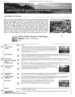
JOE'S GUIDE TO ACADIA NATIONAL PARK
CITRUSMILD.COM
THE PEAKS OF ACADIA
Below is a list of Acadia National Park's named peaks with notes and links to
the trails that lead to the summit. Most visitors to Acadia National Park are
Esty
familiar with Cadillac Mountain, the tallest and most famous peak on Mt.
34 om
Desert Island, but Acadia is sprinkled with dozens more beautiful peaks,
each with multiple compelling trails that lead to the summits. While the
elevations of Acadia's peaks may seem incredibly low compared to the
mountains out west, these hikes can still be strenuous and exposed, and the
views from the summits are still breathtaking, especially with the Atlantic
Ocean or various lakes in the background far below. The next time you are
back on Mt. Desert Island, try to tag as many summit markers as you can!
HALL
Serta Perfect Sleeper Hotel Regal
$999.00 Save 50% + Free Shipping!
Serta
Peak:
Height:
Notes:
us
Cadillac Mountain
The highest peak in Acadia is a very popular spot for sunrise and sunset and is the
Breen
only summit in Acadia that you can drive to the top of. A nice and easy hike at top is
1529
the Cadillac Mountain Summit Loop. Several longer hikes up from the bottom to the
feet
summit include the Gorge Path, the Cadillac South Ridge Trail, Cadillac North Ridge
Trail, and the Cadillac West Face Trail.
Sargent Mountain
Acadia's second highest peak is located due west of Cadillac Mountain across Eagle Lake and Bubble Pond, with
1373
feet
numerous hiking routes leading to the top, including the Sargent South Ridge Trail, the Sargent East Cliffs Trail, the
Grandgent Trail, the Hadlock Brook Trail, and the Maple Spring Trail.
945
Dorr Mountain
Located just east of its larger companion Cadillac Mountain, Dorr Mountain also has trails to the summit from all
1270
418
Flying Squadron
feet
directions of the compass, including the Ladder Trail/Schiff Path, Dorr South Ridge Trail, and the Dorr North Ridge
Dry
Trail.
Pemetic Mountain
1248
The towering and majestic peak sandwiched between Jordan Pond and Bubble Pond. Access via the Pemetic South
feet
Ridge Trail, Pemetic North Ridge Trail and the steep and intimidating Pemetic Northwest Trail.
319
Penobscot Mountain
Formerly known as "Jordan Mountain", this majestic peak has wonderful views and
Jordan
wonderous granite formations. Access via Spring Trail/Penobscot Mountain Trail and
1194
alternatively, the exposed and thrilling Jordan Cliffs Trail,
feet
118
Bernard Mountain
1071
The tallest peak of the Western Mountain pantheon on the "quiet side" of Mt. Desert Island. Access via the
Western
feet
Bernard Mountain Trail, Sluiceway Trail, and alternate start up the West Ledge Trail.
Champlain Mountain
One of the easternmost peaks on Mt. Desert Island, located along the Park Loop Road north of Sand Beach. Trails
18
Newport
1058
feet
lead to the top from all directions of the compass: the famous and intimidating Precipice Trail, the Champlain
South Ridge Trail, the Champlain North Ridge Trail, and the Beachcroft Path.
Gilmore Peak
A small peak compared to its imposing neighbor, Sargent Mountain, this often
overlooked peak offers some great views. Access via a Bald Peak, Parkman
1036
Mountain, Gilmore Peak hike or also the Giant Slide Trail loop hike.
feet
Bald Peak
A wonderful little peak that offers up some great views. Access via a Bald Peak, Parkman Mountain, Gilmore Peak
974 feet
hike; tag three peaks in one hike!
ik
Mansell Mountain
Western
949 feet
The other major peak of the Western Mountain pantheon, a plethora of trails lead to the summit, including the
http://www.citrusmilo.com/acadiaguide/peaksofacadia.cfm
1/3
J 10
Guiue LO Acadia National Park line Peaks or Acadia
Perpendicular Trail, the Mansell Mountain Trail, and the Razorback Trail.
Cedar Swamp Mountain
Tucked away in the "Middle Peaks" area, this mountain offers wonderful views of the "amphitheater" to the
942 feet
southeast. Access via the long and wandering Sargent South Ridge Trail.
Knight Nubble
A small forested companion peak to the larger Bernard Mountain in the Western Mountain pantheon. Access via
930 feet
the Bernard Mountain Trail, the nearby Razorback Trail, or the Great Notch Trail.
1919
Parkman Mountain
Formerly known as "Little Brown Mountain," this is a wonderful little peak that offers up some great views. Access
from
941 feet
via a Bald Peak, Parkman Mountain, Gilmore Peak hike; tag three peaks in one hike!
Brown
North Bubble
The taller of the two "Bubbles" (North and South) as seen from the Jordan Pond
House, the view of Jordan Pond from the summit is spectacular. Access via the North
872 feet
Bubble Trail.
918
Norumbega Mountain
852 feet
A relatively isolated peak sitting on the east shore of Somes Sound. Access via the "Goat Trail" or the connected
Brown's
Norumbega Mountain Trail.
Beech Mountain
Located in the heart of the "quiet side" between Long Pond and Echo Lake, Beech Mountain is famous for the fire
839
feet
tower at its summit. Several routes lead to the top, including the Beech Mountain Loop trails, the Valley
Trail/Beech Mountain South Ridge Trails, and the more remote West Ridge Trail.
South Bubble
The shorter and closer of the two "Bubbles" (North and South) as seen from the Jordan Pond House. Home to the
768 feet
famous "Bubble Rock" balancing at a cliff's edge. Access via the South Bubble Trail.
918
Huguenot Head
Formerly named "Picket Mountain," this is a companion peak to the larger Champlain Mountain. Access via the
thomplain
731 feet
Beachcroft Path, although the trail doesn't go over the summit.
McFarland Mountain
724
feet
Located northwest of Eagle Lake; no maintained trail leads to the top.
The Triad
This peak with three high points is located south of Pemetic Mountain and north of
Picket
Day Mountain. Hiking options include a Day Mountain Trail/Triad Trail loop and an
698 feet
approach via the remote Hunters Brook Trail.
918
Acadia Mountain
Acadia's namesake peak and oddly enough, the only peak on Mt. Desert Island that runs east-west rather than
Robinson
681 feet
north-south. Access via the Acadia Mountain Trail, this is one of the most popular and scenic hikes on the "quiet
side".
Youngs Mountain
680 feet Located northwest of Eagle Lake; no maintained trail leads to the top.
St. Sauveur Mountain
Formerly known as "Dog Mountain" and located just south of Acadia Mountain on the "quiet side" of Mt. Desert
Dog
679 feet
Island, access is via the St. Sauveur Mountain Trail.
Conners Nubble
A minor peak just north of North Bubble, this summit offers wonderful views looking down at Eagle Lake. Access
588 feet
via the North Bubble Trail.
Day Mountain
A minor peak on the south side of Mt. Desert Island near Seal Harbor. Access via the Day Mountain Trail. This is
583 feet
also the only peak you can bike to the top of via carriage road.
Valley Peak
Perhaps it could be considered merely an extension of St. Sauveur Mountain's southern ridge, but Valley Peak
530 feet offers wonderful views down onto Somes Sound. Access via a St. Sauveur Mountain loop hike or a longer Flying
Mountain/Valley Peak loop hike.
Gorham Mountain
A small peak located right next to Ocean Path that offers terrific views of the Atlantic Ocean. Access from the north
525 feet
and south via the Gorham Mountain Trail.
The Beehive
While one of the shortest named peaks in Acadia, this mountain is steep and
photogenic! Access via the thrilling Beehive Trail iron rung route or from the back
520 feet
side via the milder Bowl Trail.
Kebo Mountain
A very minor peak that is the extension of the Dorr Mountain north ridge. Access via the Kebo Mountain/Dorr
407 feet
North Ridge Trails.
Brewer Mountain
444
feet Located north of Eagle Lake; no maintained trail leads to the top.
Bald Mountain
Not quite a mountain and not to be confused with the taller Bald Peak, Bald Mountain is part of the southwest
405 feet
ridge of Bernard Mountain on the quiet side of Mount Desert Island. Access via the Bernard Mountain West Ledge
Trail.
Flying Mountain
284 feet
Credited as the shortest named peak in Acadia, a short hike along the Flying Mountain Trail leads to a beautiful
view above Somes Sound.
Great Head
Located just east of Sand Beach, this seaside high point isn't really a peak, but it does have its own summit
145 feet
elevation marker. Access via Sand Beach and the Great Head Trail.
http://www.citrusmilo.com/acadiaguide/peaksofacadia.cfm
2/3
The lloontains of llaine
un Mount Kataludin balled simply by locals). About 1860, trails were marked
IIII Mount kimon to Huntin at the Nount Nineo House, and trails on Mount Desert Island
Intriguing Stories Behind Their Names
WEIL Millied in 1/16 11:11 los the early insticators, Only a few other peaks, such as Pleasant
Minked Mountain, the Dixmont Mountains, and Mount Waldo, had trails built
Southern Coast
Steven R. Pinkhan
who the Iwentieth entury. Dozens of new trails opened up as fire lookout towers began
Downeast,
heing constitu around 1900, and while that function has basically ceased, most of the
and Lowlands
2009
original trails are still the most direct and often the only approach to a summit.
Camden.
Elevations listed in Mountains of Maine come from several sources. The Appalachian
Mountain Club (AMC), which maintains the list of New England's 100 highest mountains,
used the topographical maps as well as GPSs and other instruments to come up with the
closest current elevations of all the Maine peaks higher than 3,774 feet. All other mountain
elevations are taken from the most current topographical maps of the state. Wherever
possible, I have listed specific and accurate elevations; for others, I have listed the height
according to their highest visible contour line on the map. Elevations are always subject
to change as new maps are created and as measuring instruments and procedures become
more accurate. Most of the maps for the northern half of Maine were updated in the
late 1980s, with a few produced from 1997 to 2000. For many in the southern and more
populated regions, the older maps, often dating from 1969 and 1970, have been photo-
graphically updated.
Mountains and hills get named in many ways. Often the names are descriptive or refer
Colcord Pond from Devil's Den Mountain
to an early settler or important land owner. Surprisingly few mountains have Wabanaki
names, such as Kineo and Katahdin. Especially in the northern part of the state, the native
names today applied to mountains actually originated as names for water bodies. Native
T
the southern coast of Maine, from the border of New Hampshire to the
Kennebec River, can be divided in two-the beaches that stretch from
hunters always named the lakes, streams, and waterways that were their navigational routes.
Kittery to Portland and a coastline from Portland to Bath that's rocky. This
Later, the settlers, trappers, and hunters would apply the waterway's name to an adjacent
part of the coast has only a few small "mountains" located anywhere near
mountain or ridge.
the coast, most notably Mount Agamenticus/ in the southwestern section.
Some mountain names have been based on legend while others have been based on
like the hills of Mount Desert Island, several small hills and knobs along this
conjecture, always open to the reader's interpretation. Still others have been named for an
,tretch of coast were given the title of mountain" to aggrandize their size and
event that occurred in the vicinity. Often, a mountain named for some long-ago trapper,
importance, with such names as Mount Ararat, in Topsham, Morse Mountain,
hunter, or lumberman is the only remaining record of that individual, and today's researcher
and Bradbury Mountain. However, these small hills did serve very important
can find no reliable record of the mountain namesake's identity.
lunction by being lookouts for ships returning home and for enemy ships
This book does not cover every mountain, hill, or ridge in Maine. Many names are too
during wartime.
common and redundant, such as Round Mountain or Black Mountain, and are only listed
The southern coast also includes the lowlands, which stretch inland as
here if they have a story, fire tower, ski area, or some other notable feature associated with
much as fifty to seventy miles. It includes the mountains in the counties of
them. But there are enough unique names and intriguing stories to fill many pages with
York, Cumberland, Sagadahoc, and Androscoggin, and the land lying west
interesting glimpses of Maine history and legend.
of the Kennebec River in Kennebec County. Bordered on the north and west
by the Oxford Hills, it is bordered further east by the foothills of the upper
tennobec Region. in this coastal area, the hills and mountains are pretty well
No name/subject indux.
Polited, nowhere do they form distino I liking with the possible exception of
the mountain clasters around the Belgrade Region.
8 MOUNTAINS
SOUTHERN COANT
9
Interestingly, when Route 9 comes to the western side of Tug Mountain in township T30
MD PP, rather than climbing over the mountain, the road veers north, crosses the Machias
River, turns south, then continues east again.
Acadia: Mount
Tunk Mountain
10 1,157 feet
This solitary mountain in township T10 SD north of Sullivan takes its name from nearby
Desert Island
and
Tunk Stream, which may be a Wabanaki word for a principal, or large, stream. This is the
most likely meaning of the name, but a folk story has grown up around this name as well.
Isle au Haut
One evening, a local family invited a few nearby lumbermen to dine at their house. They
served a common meat stew with soft bread dumplings on top. Extra dumplings remained
in a dish, and when the meal was over, one of the men asked the family what they were going
to do with the leftover dumplings. The host, being something of a joker, said, "This!" as he
threw one directly at the inquiring man. That began a free-for-all and soon everyone was
throwing the dumplings at one another. Whenever one missed its mark and hit the wall, it
would make a tunk sound. Noticing this, the men coined a new word, and when they wanted
to hit a certain person, they would cry, "Tunk him!" In remembrance of the rollicking fun
they had, they called the area Tünk from then on.
In nearby Cherryfield there is a small hill known locally as Young Tunk Mountain, a
smaller version of its neighbor in Sullivan.
Wabassus Mountain
820 feet
Situated due west of Grand Lake Stream, this mountain most likely was called after the
nearby lake of the same name. According to Phillip Rutherford, the name is from the
Maliseet language and means "torchlight" or "shining. It is not clear whether this refers to
moonlight on the water or some other phenomenon.
Mount Desert Island
Wallamatogus Mountain
480 feet
ount Desert is the largest of Maine's many islands. Its tallest mountain,
Wallamatogus Mountain is a small hill in the town of Penobscot, next to Penobscot Bay.
M
(
adillac, is the highest point of land on the Atlantic seaboard until one
Fannie Hardy Eckstorm, in her extensive research of names on the coast of Maine, decided
INDI 110 Mount Sugarloaf, in Rio de Janeiro, Brazil. The Wabanakis, who came
that this one is definitely derived from a water name, not a mountain name. After inter-
here pull summer to feast on clams and fish, called it Pemetic Island.
viewing a number of locals, she concluded that the Wabanaki name Wallamatogus was akin
on emplember 5, 1604, Samuel Champlain sailed by this beautiful island and
to the word waliniticus, referring to a place where a brook runs into a cove. She further
wills. of it in his journal: "The same day we passed also near an Island about four
deduced that in this instance the cove lies at the head of Bagaduce Narrows.
live beijues
long. It is very high, notched in places, so as to appear from
the range of seven or eight mountains close together. The summits of
Washington Bald Mountain
III 983 feet
most of them are bare of trees for they are nothing but rock
I named it the
In 1789, the easternmost county of Maine was set off and named for George Washington.
Manil of the Desert Mountains." The name, which has remained for almost four
The beautiful chain of Machias Lakes in Washington County form a circular pattern around
hundred years, did not refer to the island as a barren desert, but rather to its being
the base of this small but prominent mountain. The name Washington was added to differ
described," () uninhabited. Today there are three towns on the island, and it is
entiate it from other Bald Mountains in the state. For many years, its summit was used as a
home beautiful Acadia National Park.
fire lookout station.
Hogoning III the 1850s, artists and explorers, "rusticators" as they came to
I'm alled, discovered the Island and began summering here, Many fascinating
Hail: the tooky tenan and around the ponds In addition,
46 MOUNTAINS
or MAINE
magnificent summer "cottages" were built on the eastern portion of the island, making Bar Harbor
Acadia Mountain
681 feet
a rival to Newport, Rhode Island.
David Robinson emigrated with his family from Cape Cod, first settling at Goose Cove, then
By 1913, John D. Rockefeller, Jr., George B. Dorr, and other wealthy benefactors had acquired
relocating to Southwest Harbor on Mount Desert Island. This little mountain on the west side
6000 acres, which they donated to the federal government to create the Sieur de Monts National
of Somes Sound was first called
Monument, which later, with even more acreage added, became Lafayette National Park. in 1929
Robinson Mountain for this family,
Gold Digger's Glen
the name was changed to Acadia, The new name came from l'Acadie, the French term for a broad
but was changed to Acadia when
Various stories of buried treasure in the vicinity of Somes
region stretching from the Penobscot River across Nova Scotia. Today the park encompasses some
the national park was renamed.
Sound have been passed down through the years. The
47,000 acres on Mount Desert Island, Isle au Haut, and Schoodic peninsula on the mainland.
L'Acadie, meaning "the place,"
basic story relates that either Captain Kidd, an unnamed
During the Depression, Rockefeller hired local men to complete more than sixty miles of
was the French pronunciation of
pirate, or a French captain, being hotly pursued by the
carriage paths within the parks, as well as an auto road to the top of Cadillac Mountain. These
the Indian name for a vast land
British, buried his treasure in this area. Several sites have
paths made the park more accessible to hikers and walkers of all backgrounds, and gave access to
nita with vaguely defined borders.
been named as the place where the gold was stashed,
many spectacular sites.
Some claimed that it stretched
and one of them is the notch between Acadia Mountain
The fire of 1947, which razed most of the wealthy rusticators' cottages, ended the island's
from the Maritime Provinces south
and Flying Mountain, known as Gold Digger's Glen.
status as a playground of the rich. At the same time, the fire, which swept over many of the ridges,
to New Jersey. In 1603, King Henry
Yet another explanation for the name holds that a man
opened up many of the wide vistas we enjoy today. Here, in this truly unique place, a relatively short
IV of France granted a patent
named James Long buried his treasure there under a
hike brings the reward of breathtaking views.
granting Pierre du Guast, Sieur de
large flat stone with his name chiseled on it.
Monts, exclusive rights to colonize
In 1877, Benjamin DeCosta told several more
Isle au Haut
and trade in this vast territory. In
stories about this treasure, theorizing that the booty
L
ying to the southwest of Mount Desert, and accessible by ferry from Stonington, Deer Isle, is
this patent the region was named
may have actually been money, gold, and church relics
remote Isle au Haut, about half of which is now part of Acadia National Park. When Champlain
Cadie, the first time this name
hidden by Father Biard when his early settlement was
passed this island in his explorations, he noted its several small mountains and gave it its descriptive
was mentioned in print. The name
attacked by the British.
name, which means "high island." A few years after Champlain, in 1614, Captain John Smith sailed
litter evolved into the present-day
by this conspicuous island and wrote, "The remarkablest lles and mountains for Landmarkes are
As india.
these; The highest lle or Sorico, in the Bay of Pennobskot. This was his phonetic spelling of the
Wabanaki name Solikuk, meaning "shell place." As Fannie Hardy Eckstorm noted, there were piles
Bald Mountain
167 feet
of shells-middens-all along the coast of Maine, but none was ever found on this island, leaving
Hold Mountain, a peninsula on the western side of Isle au Haut, creates a large sheltered cove
the name a mystery.
known as Moore Harbor. It gets its name, like other Bald Mountains, because it is open and
The island's highest point, at 543 feet, was later named Champlain Mountain, in honor of the
The southern end of the Bald Mountain peninsula forks and the cove in the middle is
early explorer. (Interestingly, Isle au Haut Mountain is about nine miles to the east, on an entirely
known as the Seal Trap. In an Outing magazine article published in 1885, writer Arlo Bates
different island. It's a small hill on Vinalhaven, so named because Isle au Haut can be seen from its
ulated that the name refers to the fact that the cove was a convenient place for early
187-foot summit.)
millers to trap and kill seals for their skins. Another theory is that the name may have origi-
On the 1904 topographical map of Isle au Haut, there are no hiking trails, only roads, which did
nated as ciel trappe, meaning "sky-trapped" in French.
not make a loop around the island as they do today. The eastern road ended at Head Harbor and
the western one at Western Head. On a 1944 map, however, there are nine or ten unnamed trails
Beech Mountain
841 feet
crisscrossing the island, some crossing Champlain, Rocky, Jerusalem, and Wentworth mountains.
this mountain is on the western side of Mount Desert Island, between Long Pond and Echo
A new trail, built by the National Park Service in 1990, is the Nat Merchant Trail. Born on Deer
I the and has several peaks. The tallest, overlooking Long Pond, was originally called Nipple
Isle in 1801, Nathaniel Merchant spent most of his life on the water, fishing among the forty or so
Mountain, due to its shape. In 1877, historian Benjamin DeCosta described it "as round as a
islands forming the archipelago between Deer Isle and Isle au Haut. (Sprout, Potato, Enchanted,
while's back." The name was soon changed to the more respectable Beech Mountain, for the
Devil, and Hell's Half Acre are some of the interesting island names found here ) Nathaniel even-
mmmerous opper beech trees once found there. It had also been known as Defile Mountain,
tually settled on Isle au Haut, where he lived with the family of (/m lumer and spent his days
probably il description of the rock's appearance. A fire lower has graced its summit since 1937.
wandering around the island.
the acond peak has il great ledge. once known as Storm Chill, which was believed to create
aloun out of nowhere. It lies il thousand feet above Echo Lake and is reached by the Beech
ALAUIA MOUNT DEMENT ISLAND
w
48 MOUNTAINS
Cliff Loop Trail. The most direct route to the top of the cliff is via a steep but fascinating trail
30s, they built a sluice, or long trough, to transport rocks and gravel on the eastern side
built by landscape architect Benjamin Breeze and his gang of CCC workers in the 1930s.
ml the mountain. By 1961 the Sluiceway Trail, ascending Bernard Mountain, had been built
The Canada Cliffs form the steep eastern side of Beech Mountain. Early settlers evidently
along the same course.
could see all the way to Canada from this vantage point. Grand Manan Island, with its high
cliffs, lies due east of Acadia, in the waters of New Brunswick, and would have been the piece
Bowditch Mountain H
490 feet
of Canada visible from here.
In
1880, Ernest Bowditch, a noted landscape designer from Boston, and his friend, Albert
)tis, of Belfast, Maine, first visited Isle au Haut and were so taken by its beauty and remote-
Echo Lake
ness that they soon purchased land there. Bowditch was a contemporary of Frederick Law
Nestled between Beech Mountain and Acadia Mountain on the western side of the island, this
)linsted and in his life landscaped many beautiful parks, including Rogers Fort Hill Park
beautiful sheet of water once bore the name Denning's Pond, for Benjamin Denning, who operated
III Lowell, Massachusetts, the grounds of Salve Regina University, The Elms in Newport,
a lumber business and sawmill at its outlet. Dennings Brook still memorializes his name. The
and Tuxedo Park in Tuxedo, New York. Telling their friends about this wonderful island,
lake was later known as Silence Lake, then as Crescent Lake. Today's name was inspired by the
Bowditch and Otis brought up friends from Boston, New York, and Philadelphia, and
resounding echoes created by Beech Cliff, on its western shore. Both the Boy Scouts and the Appa-
formed the Point Lookout Club, a private fishing fraternity. They proceeded to construct
lachian Mountain Club have built summer camps at this favorite canoeing and swimming spot.
it I lubhouse and a series of cottages for themselves, and new roads, library, school, and a
much-needed wharf for the fledgling island community.
When the National Park Service obtained a large part of the island from the descendants
The Beehive
540 feet
of Ernest Bowditch and other club members, they named one of the higher peaks after the
Frederick Edwin Church, student of renowned painter Thomas Cole, first visited Mount Desert
entrepreneurial Bowditch family.
Island in 1850. He gave this conical-shaped pinnacle its current name due to its resemblance to
The Bowditch Trail diverges from the Duck Harbor Trail, crosses the summit of
an old-fashioned straw beehive (skep) when viewed from the south. Rudolph Brunnow created
Bowditch Mountain, and just south of the summit joins the Long Pond Trail.
the dizzying climb up the Beehive's south face in 1916, using several dozen iron handholds and
a few ladders to help climbers across the most difficult obstacles and pitches.
The Bubbles
M 872 feet and 766 feet
Today, the Beehive is Maine's most frequently climbed mountain, and in the summer,
these two almost perfectly rounded mountains at the head of Jordan Pond were earlier known
a steady line of hikers are often seen working their way up the intensely steep cliff. Older
the Boobies or Bubbies, for obvious reasons. The Twin Hills and The Bubbles were more
maps show a small pond, called Kiff Pond, at the foot of the mountain. The pond is filling
respectable alternative names. The view of The Bubbles from the Jordan Pond House, looking
in now and disappearing. It is not known where its name came from.
Bernard Mountain
(1)
1,071 feet
Sir Francis Bernard was educated at Oxford, became a member of the bar, and was assigned
as governor of New Jersey, where he served the people well from 1758 to 1760. Trans-
ferred in 1760 to be the governor of Massachusetts, he became quite unpopular when he
enforced the Stamp Act and other English laws the American colonists found distasteful. His
authority became so weak that he was called back to England in 1769.
During his tenure in Boston he devised a scheme to gain proprietorship rights of
Mount Desert Island. While visiting his island property in 1762, he was alarmed to find
that squatters already settled on some of the most valuable farmland. Bernard restructured
the lots and tried to compel the squatters to pay him rent; however, when the Revolu-
tionary War broke out, he was forced to hastily return to England and never profit from
his land-holdings.
In the 1920s, George Dorr applied the former governor's name 10 this eastern peak of
Pond
Western Mountain.
and
"Imbbic".
When the men of the Civilian Conservation Comp were working III the HIM in the
lie Hubbies and Jondan Pond
50 MOUNTAINS
ALADIA MOUNT DEBUNT INLAND
wonder If Acadin National Park.
Native Americans who visited the island City li summer had then own lite of how The
Bubbles originated during a terrible battle between il good god and ill evil god. One of
them stood on Sargent Mountain, the other on Pemelto Mountain, and they squared off for
down a great duel. During the ensuing battle, the evil god fell from his mountain and on his
tore two mounds of rock off the cliff. These great slabs, which became the two Bubbles, way
landed on the evil god, burying him forever. The good god became the victor and peace
came to the valley.
Bubble Pond, its name notwithstanding, is actually located in a deep notch between
Pemetic Mountain and Cadillac Mountain. First called Turtle Lake, it was for a while known
as Twinhill Pond and named after the nearby Bubble Mountains.
Cadillac Mountain
K
1,528 feet
He Antoine de la Mothe Cadillac (1658-1730) was the son of a minor nobleman in Gascony.
entered the army at a young age, serving first as a cadet before rising to lieutenant in
1677. Having finished his time in the military, young Cadillac sailed to the New World in
CHAMPLAIN MOUNTAIN FROM THE EMERY PATH. BAR HARBOR. ME.
1683, where he established a home
Champlain mountain from the Emery Path
at Port Royal, now Annapolis,
Nova Scotia. In 1687, he married
Eagle's Crag and Featherbed Pond
Marie-Therese Guyon in Quebec.
About halfway between the Blackwoods Campground and
resert Island was previously called Newport Mountain, for Christopher Newport, the
They initially lived on Mount
the summit of Cadillac, the South Ridge Trail passes over
elebrated English mariner; then Green Mountain, for the pine trees that grew on its sides
Desert Island for a brief period,
Eagle's Crag (698 feet), named for a huge eagle's nest that
his mise of its many springs. When the town of Bar Harbor was still known as Eden, some
where Cadillac had been given a
once could be seen there. Other rock formations in the
members of the U.S Coastal Survey renamed this mountain Adam's Apple, but the name
grant of land. They spent a season
vicinity of Eagle's Crag also have interesting names. One
teren Mountain remained more popular. Finally, George Dorr, father of Acadia National
in Hull's Cove, but fearing an
that resembles a crouching lion was called the Old Leopard.
Park, had it changed to honor the French nobleman.
attack by the British, soon moved
South of that formation are the Old Man and Old Woman,
A summit hotel once graced its top, and at different times a cog railroad and an auto road
back to Canada.
some pits called the Pot Holes, and a nearby mound known
were constructed to enable visitors to reach the summit and enjoy the magnificent views
Cadillac's was a checkered
as Adam's Grave.
with little effort.
career that took him back and forth
One mile south of Cadillac's summit, three trails
See also: Great Hill, the White Cap.
between France and the New World,
converge at a small pond known as the Featherbed,
making a goodly number of enemies
which is nearly filled in now and rapidly evolving into a
Champlain Mountain
1,060 feet
along the way. He died in his native
wet meadow. The name may have been suggested by the
Cadillac was not the only peak once named in honor of English mariner Christopher
province, at the Castle of Sarrazine.
soft appearance of the tall yellow and purple grasses that
Newport. This mountain on the eastern side of Mount Desert Island was originally called
In 1787, his heirs petitioned the
fill the dying pond. For many years, the flat area around
Newport Mountain, but George Dorr changed the name to honor Samuel de Champlain, the
Commonwealth of Massachusetts
the pond was known as the Great Snake Flat, though
Father of New France.
to receive his grants in Maine, and
that name does not appear on modern maps. Benjamin
Christopher Newport (1665?-1617) became a privateer and in 1592 sailed to the West
when his granddaughter, Marie
DeCosta heard an explanation of the name during one of
Indies, where he took the Spanish ship Madre de Dios, claimed to be the richest prize ever
Therese de Gregoire, later visited
his early visits to the island in the 1870s. According to this
secured by an Elizabethan privateer. Newport was later employed by the London Company,
America, the Commonwealth of
tale, farmers were losing sheep that ventured too near
making four excursions to Virginia between 1606 and 1610, including being shipwrecked on
Massachusetts granted her the
the pond. They discovered that a great serpent or snake
the Bermuda Islands in 1609. He later made three voyages for the East India Company, but
eastern half of Mount Desert Island.
was devouring their precious flocks, so they formed an
died on his third excursion at Bantam, in what is now Indonesia.
This highest point on Mount
armed band and slew the creature.
Samuel de Champlain (1567-1635), born at Brouge, France, learned the art of naviga-
lion from his sea captain father. An able and enterprising young man, he was a soldier in
52 MOUNTAINS
OF MAINE
ACADIA: MOUNT DESERT ISLAND
53
AND ISLE AU HAUT
MOUNTAIN WHA renamed in nonor or Cleorge Dorn the man often referred to
as the father of Acadia. This wealthy, energette visionary spent his emly years on Mount
aamini the climber In the more difficult areas, which also given the hiker the feeling of an
Desert Island and remained, exploring every corner of the Island. This mountain's northeast
Spine limb. A series of ladders in the upper Mri tion Have this path its name.
shoulder is also known as Sieur de Monts Crag.
time look its toll on the Ladder Trail. 11 WAN abandoned for a few years, but in the 1930s,
Dorr Mountain offers several outstanding hiking trails. The Dorr Mountain Trail was
the ( Ivilian Conservation Corps, under the direction of Madison B. Knowles, sought to
originally known as the Emery Path, named in honor of John S. Emery, and its construction
lising the trail back to its original style, and basically had to rebuild it. They used Bates's
was financed by Emery's widow. This steep one-and-a-half-mile trail, which traverses the
original stones until they ran out of available rock. Luckily for the crew, the road up Mount
east side of the mountain, contains many rock steps and switchbacks.
4 mililla was being built about the same time. Stone was trucked from there and painstak-
George Dorr created another trail as a memorial to Mrs. Charles Homans, a summer
listly hand carried up the mountain and put in place on the Ladder Trail. The current Ladder
resident who donated large tracts of land for the National Park. This path ascends the east
timil follows most of Bates's original path, except for the last 175 or so steps, where today's
face of the mountain, and contains more than four hundred perfectly designed steps and
mail takes il more direct approach to the summit.
switchbacks. Oddly, the path did not lead anywhere. After climbing up the steep side of the
A mail up Dorr Mountain from the north was built in memory of Jacob Schiff, a man
mountain, it abruptly ended, and nobody seems to know why. In 2003, the National Park
who contributed in many ways to the trails of the Bar Harbor region. Now part of the Dorr
Service and Friends of Acadia reopened this trail, making another circuit of Dorr Mountain
Alumnian Trail, this fascinating path first climbs up more than six hundred stone steps, then
possible from the eastern side.
along the lip of a cliff some seven hundred feet above Tarn Pond and connects with the
In 1915, Dorr built a short, steep trail up the mountain's east face and named it in memory
lormer Jomans Path, Emery Path, and Kurt Diederich's Climb on its way to the summit.
of Kurt Diederich, grandson of Boston artist William Hunt. It includes an impressive 700-step
Duck Harbor Mountain 15
309 feet
stone stairway as it winds its way through a reconstructed talus slope. The former Kurt Diederich
Climb is now known by the less impressive title of East Face Trail, but still brings a thrill to the
the name of Duck Harbor, a cove on the southeastern end of Isle au Haut, harks back to the
hiker and stimulates deep respect for the backbreaking work put into moving the rocks and
mid 1800s, when the inhabitants of the island would hunt ducks during the molting season,
stacking them cleverly into steps.
when the ducks could not fly. Surrounding large flocks with their boats, the hunters would
hirld the birds into this small inlet where they could be killed without any chance of escape.
In 1891, Waldron Bates, a young, energetic lawyer from Boston, began building the
Ladder Trail, another challenging and dizzying route up the cliff on the east side of the
Many stories were told of the huge numbers of birds taken.
The name of the harbor was later transferred to the small mountain, and today, the
mountain. Bates and his small crew painstakingly moved thousands of rocks into place to
limbor serves as the entrance to the Isle au Haut portion of Acadia National Park. The Duck
build a staircase of 1,075 stone steps. This was also one of the first trails to use iron rungs
Habbor Trail crosses the summit of this small mountain.
Indian Pass
Eliot Mountain
456 feet
The deep, long notch bétween Dorr Mountain and Champlain Mountain was once a route used by
this small mountain on the east side of Northeast Harbor was originally known as Asticou's
the Wabanakis, who summered on the island, used when they hunted for beaver in the local ponds.
Mountain, for the chief of the Penobscot band that summered here. Later it was sometimes
Archaeological evidence indicates that the local native tribes have been visiting the island, especially the
called Savage Mountain, after a local family, but eventually was named in honor of Charles
Somes Sound area, since around 1000 BC.
William Eliot, noted conservationist and president of Harvard College.
Indian Pass was logged several times during the 1800s. Early loggers cut and harvested logs,
In 1869, after a trip to Europe, Eliot wrote several articles on education that attracted
floating them down the notch during the spring melt. They first hauled the logs to the Tarn and Otter
wide attention. Later that year he was selected to be president of Harvard College, a post he
Cove by sled, then used a Model T to get them to their destination.
held for four decades, retiring in 1909 at the age of seventy-five. In 1880, his son Charles
On the southern end of the pass, Harold Peabody and his crew opened a trail in 1925 from
Ellot led a small group of Harvard students, the Champlain Society, to Northeast Harbor,
the Canon Brook Trail leading north to the high point between the two mountains and named it
where they set up camp for two summers and spent their days performing scientific experi-
the A Murray Young Path for one of their comrades. A tablet on the path is inscribed "In Memory
ments and exploring.
of Andrew Murray Young, who loved this Island where God has given of His Beauty with a lavish
Taken by the beauty of the area, Charles advised his father to build a summer home on
hand 1861-1924. Canyon Brook, which often runs dry in the summer and only flows after a good
11
lot that he described as "a site with beautiful views of seas and hills, good anchorage, fine
rainstorm, was named because its bed resembles à western canyon, but the letter y got dropped over
rocks and beach and no flats." President Eliot liked the idea and subsequently purchased a
time, and the misspelled Canon Brook name is now the official designation.
100-acre lot that included the Asticou Ridge and some shore frontage.
In 1902, in response to logging activity high up on Dry Mountain and Green Mountain
56 MOUNTAINS
OF MAINE
ACADIA: MOUNT DESERT ISLAND
57
AND ISLE AU HAUT
Asticou Ridge
This ridge on the lower flanks of Eliot Mountain was named after a local Penobscot Indian leader.
Joseph H. Curtis purchased land in Northeast Harbor in 1880. On the lower part of the ridge he built
a beautiful stepped garden that he called Asticou Terraces. Today, the Asticou Terraces Trail connects
some of the higher mountain trails to nearby Thuya Gardens.
In 1613, two Jesuit missionaries, accompanied by Jesuit theologian Pierre Biard and forty-five
hearty colonists, sailed southward for Kedusquit, later the site of Bangor, to claim the lands for
Biard's sponsor, Antoinette de Pons, marquise de Guercheville. In his search for the legendary land of
Norumbega, Blard landed instead at Somes Sound, on Mount Desert Island.
One legend relates that Asticou, a local Penobscot* chief, lay ailing from a mysterious illness and
sent for the missionary in order to ask the priest's blessing. Other versions of the story say that Asticou
only feigned the illness in order to gain the friendship of these new Europeans. Either way, Biard's
blessing apparently cured the chief and gained the confidence of the tribe, so Biard decided to stay
and established his mission nearby.
Valley Cove from Flying Mountain
(Dorr and Cadillac today), Eliot published a small article titled, "The Proper Development
Flying Mountain { 271 feet
of M.D.I." Gathering the support of other summer residents who wanted to protect "their
HOWN originally as Carroll Mountain after a local resident, this hill was later endowed
beloved retreat," he launched the Hancock County Trustees of Public Reservations. Eliot
with its current name based on a Penobscot legend. C. Tracey, one of the early historians
died at his Northeast Harbor home in 1926, at the age of ninety-two, one of America's most
it Mount Desert Island, was told that the local Wabanakis believed this mountain broke
enlightened educators and one of Mount Desert Island's favorite visitors.
all from St. Sauveur Mountain and "flew down" to its lower perch next to Somes Sound.
Probably this tale alludes to a rockslide that may have occurred centuries ago.
Fernald Hill
39
280 feet
Between Flying Mountain and Acadia Mountain lies Man-o-War Brook, so named
Fernald Hill is the highest land on Fernald Point, a broad peninsula on the west shore near
minuse, during the War of 1812, the British frigates came here to renew their supplies of
the entrance to Somes Sound. The local tribes camped there regularly for more than three
finals water. Somes Sound was apparently deep enough for the frigates to come close to
thousand years. Some scholars say it was also the site of Father Biard's doomed settlement,
aline. On the side of Acadia Mountain, above the valley through which this brook flows, is a
though others believe the Jesuit priests located along the valley of Man-o-War Brook, farther
bill lill known formerly as the Crow's Nest.
up the sound. According to Phillip Rutherford, the peninsula and its hill were named for
Tobias Fernald, an early settler.
Gilmore Peak
1,030 feet
Rufus Wilmot Griswold, in his Republican Court, was one of the first to try to prove that
apretal sources say that this rocky peak between Parkman and Sargent mountains was named
Charles Maurice Talleyrand, the notorious French diplomat, was actually born on Mount
IIII it III al family, though a search through records finds no family there by this name.
Desert Island, on Fernald Point, and not in Paris as his first biographer stated. One story
In 1921, Charles Grandgent, an active and enthusiastic member of the Northeast Harbor
says that Edward H. Robbins, later lieutenant governor of Massachusetts, found him there
Pittle ( committee, built a path that bears his name. Beginning at the summit of Sargent
as a young boy, wandering around aimlessly. It is also said that in 1753, the older residents
Mountain, the trail descends into Grandgent's beloved wilderness valley, then ascends
of the area recognized him as the son of a local girl and a French ship's captain, though his
steeply over the summit of Gilmore Peak, where it ends at the Giant Slide Trail.
biographers agree he wasn't born until February of 1754. One version says his mother died
and a French gentleman took the boy away. Another, more passionate version has the boy
Gorham Mountain
522 feet
taken away from his mother, who subsequently dies of a broken heart.
oner between the Otter Clill and the Beehive, this small ridge was first known as the Peak
Whether he was born at Mount Desert Island or in Paris, the lame cleric went on to be one
of 11⑈ litters, but around the late 1800s the name was changed to Gorham Mountain. It is not
the most controversial men in French history. Switching loyalties as best suited his ambitions,
known whether il was named for il person who first discovered and climbed it, for a nearby
Talleyrand was, at various times, advisor to Louis XVI, supporter of the French Revolution,
il
writer. 111 for the town of Gorban in southern Maine. The first possibility is the most likely.
real estate speculator in Massachusetts, and an advisor to the emperor Napoleon.
A mill has led 10 the summit of this mountain lot many years. and in the enrly 1900s. it
AUADIA MOUNT DESKRT ISLAND
NO
58
MOUNTAINS
The Bowl Bar Harbor, Me.
the building of a steep trail up Huguenot Head that incorporates some 1,482 stone steps.
Named after Mrs. Smith's summer estate, the Beachcroft Trail begins at the Tarn, goes over
Huguenot Head, and ends at the summit of Champlain Mountain.
Kebo Mountain E 407 feet
the derivation of this name remains a mystery. Phillip Rutherford, in his Dictionary of Maine
Plue Names, ventured to say that if it is of Indian derivation, then it must be Wabanaki and
mean "I fall," though he sites no reference for this. Perhaps Kebo refers to an unfortunate
in lilent when someone fell from this mountain's steep ledges.
Mansell Mountain
193
938 feet
'ill Robert Mansell was born in 1565, third son of Sir Edward Mansell (or Mansfield) and
Hrandson of Henry, earl of Worcester. He was married in 1617 to a Miss Roper, a maid of
humor in Queen Anne's household, and in 1592 began a successful seafaring career, being
The Bowl near Gorham Mountain
hughted for helping take Calais, France, in 1596. He was promoted to vice admiral in 1601,
and appointed in 1604 as treasurer of the Royal Navy.
colored trail system stretched from Gorham Mountain
Mansell was very active in developing the English glassblowing and winemaking
The Bowl
north to Champlain Mountain. Today, the Gorham
Indistries. A member of the early merchant adventurers belonging to the Council of
Mountain Trail extends across the mountain from the
Landscape artist Frederick Church
Virginia in 1607, he also helped send Henry Hudson to Canada in 1609. Later, he was a
Beehive south to Monument Cove. A side loop trail
attempted to rename this small,
1114 miner of the first board of directors of the Northwest Passage Company in 1612, and in
on the southeast side of the mountain is known as the
circular pond nestled below the
11,'10 will on the board of the New England Company, which helped finance the Pilgrims'
Cadillac Cliffs Trail.
Beehive, Champlain, and Gorham
colony at Plymouth.
mountains. In the 1870s, he briefly
III 1622, Sir Robert, then commander of the Royal Navy, received a deed to Mount
Great Hill N 552 feet
changed the name to Loch Anna,
Dear Island for a "note of one hundred and ten pounds." Samuel de Champlain had already
Just north of the Whitecap, the Cadillac Mountain
as many Scottish names were being
mined the island, but Mansell now claimed it for England and renamed it Mount Mansell
Auto Road makes a sharp turn south. This is near
introduced to Acadia at the time, but
Island. The colonists of Massachusetts used this name for about seventy years, but eventually
the top of Great Hill, the former name of Cadillac's
the local name, The Bowl, won out
the name Mount Desert was restored.
northern ridge. The mountain's old carriage path
and has been retained on maps since.
In 1848, the island township of Tremont was incorporated as Mansel, later changed to
approached the summit from the north, going over
114 unrent name. The small fishing community of Manset in Tremont was also named for
Great Hill and Whitecap on its way to the summit. It was near Great Hill that the Howe
1/114 great naval officer, but someone in the early days mistakenly crossed the last letter and
brothers, summer visitors to Bar Harbor in 1882, were accosted by an unknown high-
changed the name to Manset instead of Mansel.
wayman and forced to give up all their valuables.
About 1868, when the Reverend Benjamin DeCosta and friends visited the island, he
renamed Brown's Mountain, near Somes Sound, as Mount Mansell. George Dorr subse-
Huguenot Head
720 feet
changed the name of that peak to Norumbega Mountain and later bestowed the east
Mountains seldom change their basic shapes, but this little mountain, first called Round Hill,
forroste of Western Mountain with the name Mount Mansell, in tribute to Sir Robert.
gained a new name-Peaked Hill, indicating a different shape when viewed from another
angle. This new name evolved into Picket Hill, but eventually George Dorr gave it a more
McFarland Mountain
724 feet
interesting name: Huguenot Hill, because Pierre du Gua, Sieur de Monts, an important
I III nied just outside of the town center of Bar Harbor, this small mountain was named for
figure in the early European history of the region, had belonged to that group of French
humer McFarland, an early shipbuilder. In the late 1930s, the Bar Harbor Outing Club built
Protestants. During the sixteenth century, the Huguenots were persee uted by the French
an HOO loot ski trail with a 1,330-foot long rope low on this mountain. By 1949, they had
Crown. Many fled France, and some of them came 10 various colonies In North America,
milled more trails the Stemwinder, Loop, and West Side Trail. The ski area was operated
Mrs. C. Morton Smith of Philadelphia, it summer resident at Hat Harbor, financed
loi many years, but finally closed after 1971.
MOUNTAINS
ADM MOUNT DEBERT ISLAND
01
AND ⑉ A11 WAIM
Monte Carlo
277 feet
In M.E. Sweetser's 1888 Chisholm's Mount Desert Guide Book, he mentions a small mountain
Hadlock Ponds and Hadlock Brook
of called "Monte Carlo, the most northerly spur of the Green Mountain range reaching a height
these water bodies are tucked against the southeastern flanks of Norumbega Mountain. Samuel
320 feet, and commanding an enchanting view over the bay and the sea, Hull's Cove,
Hadlock moved his family to Northeast Harbor in 1785, and built a sawmill at the outlet of Lower
and the Gouldsborough Mountains." Chisholm also related that in 1888, Charles T. How of
Hadlock Pond. His venture was short-lived, for in 1789 he got into a fight with a drunken visitor
Boston constructed a carriage road to the summit of this little hillock, and several summer
named Eliab Littlefield Gott. It appears that he may only have been defending himself against the
cottages-Highbrook, Woodbury Park, and Abbey's Retreat-were built there.
ounger and stronger man, but newspapers of the day indicate that he was indicted, tried, convicted,
No Monte Carlo name appears on modern topographical maps. Apparently the name
and hanged for killing Gott. Hadlock's son Samuel, Jr., continued to run the lumber business until the
only seemed necessary while the grand summer cottages graced its slopes. They all burned
burned. He then removed to Little Cranberry Island and bought a ship, filled it with dried fish he
in the 1947 fire.
(aught in Labrador, and began a successful new business.
The Upper and Lower Hadlock Ponds were named for this family, and nearby Baid Mountain
Mount Gilboa
147 feet
was once known as Hadlock Mountain. The outlet brook of Lower Hadlock Pond has its own story.
Like Mounts Nebo, Pisgah, and others, this small hill in the town of Tremont, in the
In 1883, the Mount Desert Herald published a story called "The Legend of the Haunted Mill,"
southwest corner of Mount Desert Island, got its name from the Bible. Mount Gilboa is
recounting a legend about strange creatures similar to werewolves that frightened residents and
named in the Old Testament account of the defeat and death of King Saul in a battle with the
divoured sheep and other livestock in the area around an old mill on Lower Hadlock Pond. It is said
Philistines (recounted in the books of Samuel and Chronicles).
that one day the mill started itself up, lights tuned on and off, and strange voices were heard.
Another explanation offered to explain the reputed weird phenomena is that Captain Kidd and
Norumbega Mountain
852 feet
due of his crew buried treasure at the spot where the mill was later built, and Kidd then killed the
In the early centuries of exploration, it was the unspoken goal of the English, French, and
poor crewman so his spirit would guard the treasure until Kidd returned to claim it.
Spanish to find Norumbega, a fabled city of gold that was thought to be somewhere around
the forty-fifth parallel in the region of Maine.
Parkman Mountain
920 feet
Fannie Hardy Eckstorm, in her Indian Place Names of the Penobscot Valley and the
I lite Brown Mountain, like its higher neighbor Brown Mountain (today's Norumbega
Maine Coast, states that the word is definitely of Indian derivation, but gives no interpreta-
Mountain), was named for John Brown, a nearby settler. George Dorr subsequently renamed
tion. Phillip Rutherford wrote that it might be Wabanaki meaning "still water between falls,"
I ille Brown in honor of Francis Parkman (1823-1893), one of America's greatest historians.
making it a reference to the Penobscot River above Bangor. The early writers did continu-
Parkman, son of a Boston minister and educated at Harvard, read classical languages as
ally connect the fabled city with the upper reaches of this mighty river, so if the city actually
really as he did English. An avid explorer, he made countless trips to the places he subse-
existed, it would most likely have been there, not along the coast.
quently wrote about-the American West, New England, Canada, and Europe. He loved
Eckstorm also cites that Father Biard, an early missionary on Mount Desert Island, wrote
likking, and his college chums could never keep up with him in his jaunts among the forests
a passage in his journal that translates as "The old geographers speak of a certain Norumbega
and mountains.
and give the names of cities and strongholds of which today no trace or even report remains."
In 1844, he took a grand tour of Europe, and then in 1846, spent several months
She continued that Lescarbot, Samuel de Champlain's companion on his trip to Acadia, wrote
following the Oregon Trail, living among the Native American tribes that fascinated him so.
in his book, New France, that the Spaniards have been "drawing a long bow," or getting aggres-
the western trip took a toll on his health, damaging his eyesight, but he managed to write
sive over, "a great and powerful city, which they have placed about the forty-fifth degree. If
minietous books, get a law degree from Harvard, spend several months in a monastery in
this fair town ever existed I would fain know who has destroyed it in the last eighty years;
Home, and become a professor of horticulture at Harvard in 1871. He left us with many
for there is nothing but scattered wigwams made of poles covered with bark or skin, and the
wient historical works-The Oregon Trail (1849), The Conspiracy of Pontiac (1851),
name of both the settlement and the river is Pemptegoet and not Agguncia." This refers to the
Plancers of France in the New World (1865), The Jesuits in North America (1867), La Salle
Penobscot River and the Huron name for Norumbega. Like the fabled city of El Dorado in the
ml the Discovery of the Great West (1869), and Montcalm and Wolfe (1884).
south, Norumbega, the northern city of gold and wealth, remains a legend.
This mountain was originally called Brown's Mountain after John Brown, who owned
Pemetic Mountain
1,247 feet
a large plot of land to the north. It was George Dorr who changed the name to honor the
alled Black Mountain by the settlers for its color, it was later changed to the Wabanaki
mythological city.
name of the island. Father Francis Biard, the early missionary, referred 10 Mount Desert
Inland its Pemetig in his 1611 journal. Pemelic roughly means "II range of mountains." Fannie
62
MOUNTAINS
OF MAINE
ALADIA MOUNT DESERT ISLAND
03
Hardy Eckstorm felt the original term must have had some form of the root adn in it, as the
The south shoulder of St. Sauveur Mountain is now known as Eagle's Cliff, but this
Wabanakis almost always used this sound to signify mountains.
previpitous ledge has also been known as Bow Arrow Hill, Storm Cliff, Thunder Cliff, and
Visitors who launch their kayak or canoe at the public boat access site on Eagle Lake will
Valley Peak. The latter name has been retained in the name of the trail that ascends northerly
find themselves gazing across the length of the lake toward Pemetic Mountain. Originally
In the top of Eagle Cliff and on to the summit of St. Sauveur Mountain, where it continues
known as Young's Pond, this scenic water body was renamed by Frederick church in the
along the top of the ledge and connects with the Acadia Mountain Trail.
1870s for an eagle's nest on the surrounding cliffs. One of the most frequently visited places
in Acadia National Park, Eagle Lake is encircled by carriage paths and foot trails.
Sargent Mountain
1,379 feet
this peak was first known as
Penobscot Mountain
1,196 feet
Brassy Mountain for the golden
The Bates Chasm Trail
Because of its nearness to Jordan Pond, this eminence was called Jordan Mountain for many
line created when the setting
Waldron Bates was one of Mount Desert's prolific trail
years, but later received the name Penobscot, which is somewhat out of place. Fannie Hardy
41111 shone on it. The name was
builders. Graduating from Harvard in 1879, he got a law
Eckstorm found that the term Penobscot referred only to a ten-mile section of river between
hanged to Sargent Mountain
degree from Boston University and took a position with a
Treat's Falls at Bangor and Old Town Great Falls. The name literally means "the rocky place"
after the family that owned land
prestigious law firm in Boston. His first and real love was the
or "the descending ledge place," and at that section of the Penobscot River there were a series
111 the north of the mountain.
outdoors, however, and he spent many of his summers at
of rocky ledges requiring a great amount of portaging.
'augent Mountain Pond, a small
Bar Harbor, building amazing and awe-inspiring paths.
In 1835, William Bennett constructed the first road to Jordan Pond, where he built
6,111 located in the dip between
A tireless hiker and explorer, he carried many of the
a house and several mills. Three years later, two brothers, George N. and J. S. Jordan,
langent and Penobscot mountains,
stones himself to hundreds of stone steps in the Ladder
purchased the mill and property from Bennett and
was first called Summit Lake, then
Trail, Goat Trail, and Jordan Bluffs Trail. In all, Bates has been
constructed a permanent lumber camp at the pond
The Jordan Pond House
I like of the Clouds, a familiar
credited with having constructed more than one hundred
in order to take advantage of the giant trees that were
In 1883 Charles T. How of Boston
name to White Mountain hikers.
fifty miles of trails on the island by the time of his accidental
growing on Pemetic and Penobscot mountains. In
egend had it that the pond was
death in 1909.
discovered the beauty of the pond
1847, the brothers built a house at the south end of
below Penobscot Mountain and
birth bottomless and home to a sea
Bates also purchased and donated forty acres, as the
the pond and opened a rough path for hauling logs
purchased the Jordan brothers'
repent.
beginning of the national park we know today. He also left
from the pond to the beach at Seal Harbor. This
property to entertain his friends at
The circular head of the ravine
$5,000 toward the building and maintaining of his beloved
allowed them to use oxen and horses in the winter
seasonal picnics. He added rooms to
between Sargent Mountain's
paths. In 1910, the Village Improvement Association, whose
to haul the logs across the snow and ice, making
the original house as more and more
with ridge and the south ridge of
roads and paths committee Bates had chaired for many
transport much easier.
folk began coming to the pond, and
Penobscot Mountain reminded the
renamed the Chasm Brook Trail on the north side of
Unfortunately, in 1852, a raging forest fire burned
from this came the famous Jordan
only explorers of a Greek amphi-
Sargent Mountain in his honor.
all the trees and soil on the sides of the mountains,
Pond House, where generations of
theater and they named it accord-
bringing such a financial burden to the siblings that
visitors have made it a custom to stop
imply. The Amphitheater Trail, built in 1914, passes through the small cirque.
their business was ended. Jordan Pond and Cliffs were
for afternoon tea and popovers.
The three-mile-long Giant Slide Trail follows along the western side of Sargent Mountain.
named for these unfortunate brothers.
After passing through a wooded section, the trail comes to a jumble of huge boulders at the
loot of a great slide, known locally as the Giant Slide for its enormous size. Passing through
St. Sauveur Mountain
690
feet
1/114 incredible jumble of rocks, the path then descends through a deep notch between
Local legend tells how a somewhat crazy and senile woman from Somesville climbed to
Parkman Mountain and Gilmore Peak, ending at the Maple Spring Trail.
the summit of this mountain with her dog. Because the smaller mountain below had been
named Flying Mountain, she hurled the poor dog off the cliff to see if he would fly down to
Sawyer Mountain
490 feet
the other mountain. Unfortunately for the dog, her attempt to defy gravity did not work.
Phenezer Sawyer (1757-1838) was born and raised in Falmouth, now Portland, Maine,
For many years, this peak was known as Dog Mountain for that unlucky canine. It was
where he learned to be a fisherman, His father Ebenezer came from a fishing family in Cape
renamed to commemorate the failed Jesuit mission on Fernald Point nearby. Father Biard and his
listbeth and his mother Susannah Yeaton descended from a fishing family on the Isle of
small band who settled there in 1613 had been connected (1) St. Sauveur Church in France and
should Seeking opportunity. the younger Ebenezen and his wile moved east, settling on Isle
had christened their new home with the same name. The 110016 in Englinis means "Holy Savior,"
IIII Haust about 1791. Here, he continued fishing until he died in the winter of 1838, and his
64 MOUNTAINS
ACADIA: MOUNT DENENT ISLAND
as
OF MAINE
only son, Paul, feeling isolated on
The Herrick Trail
frails on Western Mountain
the small island, moved to Deer
This former trail was located on the western side of Isle au
The Perpendicular Trail
Isle, thus ending the name on
Haut and once connected the main village with the houses at
Wedern Mountain has many interesting paths, but this one on the northeast side of the mountain
Isle au Haut. Sawyer Mountain, a
Moore Harbor. It crossed over the top of Black Dina (184 feet),
wands out. In 1933, the Civilian Conservation Corps, working with the island's local public works
long, flat ridge, is named for this
a ledge on the side of Sawyer Mountain named for the dark
graips, took on the challenging job of building a new path up the mountain to replace an old trail built
early family. It lies in the middle
color of the rock.
of the island, just south of Rocky
by the Southwest Harbor Improvement association in 1913.
The trail was named for the seafaring members of the
Vernon Lunt, the technical foreman, and his crew of about twenty-two men faced a most inter-
Mountain. Oddly, Sawyer Notch,
Hérrick family, a large clan of mariners and fishermen that lived
riting challenge in the form of a large talus slope. Instead of choosing an easy route around the pile
a small cleft, lies north of Rocky
on the Blue Hill peninsula and occasionally used the Isle au
of huge boulders, the crew spent many grueling days rearranging the rocks into a great, winding set
Mountain, separating it from
Haut Thorofare as a protected anchorage.
of stairs, complete with a small resting bench partway up, The trail climbs an amazing 704 steps across
Champlain Mountain.
the talus slope and then heads through the woods, working its way up steeply to a series of iron rungs
The Triad
00
690 feet
If approaches the summit of Mansell Mountain. The Perpendicular Trail is a lasting monument to the
incredible work performed by the crews, and rivals many other higher paths located in the East.
This small mountain in the south-central area of Mount Desert Island has one main peak
and two smaller peaks on its western ridge, making three summits, hence the name.
the Razorback Trail
Lafy maps of Western Mountain show an unnamed trail running from Gilley Field to the top of Mount
Wentworth Mountain
299 feet
Mansell, Lying south of and paralleling the Mansell Trail, it climbs up through a ravine and over a series of
Joshua Wentworth, a farmer and mariner, left his native New Hampshire as a young man,
exposed ledges and outcrops. In the mid-1970s, the National Park Department reopened this obscure
married at York, Maine, and then went to Frankfort, Maine, where he began a large family.
naming it the Razorback Trail for the bony ledges it traverses on its strenuous climb up the mountain.
About 1824, he moved to Isle au Haut, where he farmed and fished, earning a meager living.
Wentworth Mountain is supposedly named for his daughter Betsey, who was sixteen
years old when the family first came to Isle au Haut. The Loop Road, which traverses most of
The White Cap M 920 feet
the island, goes over Wentworth Mountain, near the center of the island.
IIII 10 are several mountains in Maine named White Cap, but the one on Mount Desert
Ishand IS surely the smallest. Named for the white rocks located on its peak, this mountain is
Western Mountain
DS
1,071 feet
di
linally a northern arm of Cadillac Mountain, and the auto road passes just under its small
The highest mountains of Mount Desert are clustered in the southeastern quadrant of the
mitumit. For a number of years, a small side trail has ascended White Cap from the east,
island. On the western side of the island are a few small mountains between Somes Sound
111 ling, its summit.
and Long Lake, the highest and largest of which is Western Mountain, which is actually a
range of hills rather than a single mountain.
Young's Mountain III
205 feet
Known originally as Westward Mountain, it has four summits, named West Peak,
I
Humah Young, a participant in the Boston Tea Party, moved from Cape Cod to Bar Harbor
Bernard Mountain, Knights Nubble (named for a local resident), and Mansell Mountain.
(then alled Eden) before 1774, with his son Captain Ezra Young. They settled at Duck
The prominence originally called East Peak was renamed Bernard Mountain by George
thook, but the father later moved to Trenton, Maine, and died in Lamoine in 1832.
Dorr for Governor Bernard, the last English governor, who was driven out during the
In March 1776, Captain Ezra was appointed to serve on the Committee of Correspon-
American Revolution.
Safety, and Inspection, a very important position in each community during the
On the southeast side of the mountain is a large hollow, where a large stream was
America Revolution. Later that year, he was elected captain of the militia, and at Bar
dammed and a water-powered mill was built in 1860. The mill operated for a few years,
Hashut's first meeting was chosen moderator and first selectman. He died in 1812, the most
utilizing the unlimited forest surrounding it, until one cold winter night it mysteriously
influential and important person on the island. Young's Mountain on the upper half of the
caught fire and burned to the ground. Today, the site is simply called Mill Field and
14/11/11 was named for this early public servant.
is the place where several hiking trails branch out to climb Western Mountain by
different approaches.
See also: Bernard Mountain and Mansell Mountain.
66 MOUNTAINS
ALADIA. MOUNT DEVERT INLAND
of
OL MAINE
Chamberlain, E. G. "Panorama from Pleasant Mountain," Appalachia, June 1925.
Smith, Rev. Arthur Warren, and Samuel Pearce Merrill. "Historic Sketch of the Town
Emery, Edwin. The History of Sanford, Maine 1661-1900. Edited by William Morrell Emery.
of Sedgewick." Centennial of the First Baptist Church of Sedgewick, Maine, June 11-18,
Privately published, 1900.
1905. Souvenir book published by the first Baptist Church.
Forbes, Charles B. "Mount Agamenticus, Maine." Appalachia, December 1953.
Tewksbury, John P. "Referring to the Naming of Mount Battie." Sprague's Journal of
Maine History, 1925,
Knight, Ernest H. Raymond Then and Now. Raymond, Me.: Raymond Women's Club, 1978.
Watts, Jacqueline Young, and Isabel Morse Maresh. Lincolnville Early Days, vol. 1.
Ridlon, G. T., Sr. Saco Valley Settlements and Families. Portland, Me.: privately published, 1895.
Lincolnville, Me.: Lincolnville Historical Society, 1976.
Swett, Sophia Miriam. "Agamenticus" and "Passaconaway," Stories from Maine. New York:
Williams, Chase & Company. History of Penobscot County, Maine. Cleveland, Ohio:
American Book Co., 1899.
Williams, Chase & Co, 1882.
Taylor, Robert L. History of Limington, Maine 1668-1900. Norway, Me.: Oxford Press, 1975.
Williamson, Joseph. Frankfort and the Origin of the Name of Mount Waldo. Bangor Historical
Wheeler, George A., and Henry W. Wheeler. The History of Brunswick, Topsham and
Magazine 7, 1891.
Harpswell, Maine, Including the Ancient Territory known as Pejepscot, 2 vols. Boston:
W.P.D. "Ragged Mountain Reservation." Appalachia, June 1925.
Alfred Mudget & Sons, 1878.
Acadia: Mount Desert Island and Isle Au Haut
Down East Coast and Lowlands
Appalachian Mountain Club. AMC Guide to Mount Desert Island and Acadia National Park.
Davis, Varina H. Jefferson Davis, Ex-president of the Confederate States of America,
1st through 7th eds. Boston: Appalachian Mountain Club, 1977 to 1993.
A Memoir. New York: Belford Co., 1890.
Collier, Sargent F. Acadia National Park, George B. Dorr's Triumph and the Illustrated Story of
Drake, Samuel Adams. A Book of New England Legends and Folklore in Prose and Poetry.
Mt. Desert, the Most Beautiful Island in the World. Farmington, Me.: Knowlton
Boston: Little, Brown, 1902.
and McCleary, 1965.
Eaton, Cyrus. Annals of the Town of Warren in Knox County, Maine, with the Early History
DeCosta, Benjamin F. Rambles in Mount Desert with Sketches of Travel on the New England
of St. Georges, Broad Bay, and Neighboring Settlements on the Waldo Patent. Hallowell,
Coast from Isles of Shoals to Grand Manan. Boston: A. Williams Company, 1891.
Me.: Masters and Smith and Co., 1851.
Eliot, Samuel A. "The Romance of Mount Desert." New England Magazine, August 1989.
Eckstorm, Fannie Hardy. Indian Places of the Penobscot Valley and the Maine Coast. Orono,
Fleming, Deidre. "Mountain Mystery: Homans Path at a glance." Maine Sunday Telegram,
Me.: University of Maine at Orono Press, 1941.
August 17, 2003.
Forbes, Charles B. "Blue Hill in Maine." Appalachia, December 1953.
Hale, Richard Walden, Jr. The Story of Bar Harbor, an Informal History Recording
"Schoodic Mountain." Appalachia, December 1957.
One Hundred and Fifty Years in the Life of a Community. New York: L. Washburn, 1947,
Harden, Brian, et al. Shore Village Story, An Informal History of Rockland, Maine. Rockland,
Hansen, Gunnar, ed. Mount Desert, An Informal History. Published by the Town of
Me.: Rockland Bicentennial Commission, 1976.
Mount Desert, 1989.
Karl, Alice Wardwell. "Mt. Megunticook: Here History, Tragedy and Breath-Taking Beauty
Lapham, W.B. Bar Harbor and Mount Desert Island. Augusta, Me.: Farmer Printing, 1888.
Combine." Lewiston Journal, October 29, 1938.
With Pen and Pencil at Mount Desert. New York: Liberty Printing Company, 1886.
Lincoln, Franklin P. "Long Ago a Little Girl Made a Monster Out of a Mountain."
"Legends of Mount Desert: The Witch Ponds." Mount Desert Herald, August 7, 1885.
Portland Press Herald, May 4, 1954.
Martin, Clara Barnes. Mount Desert on the Coast of Maine. Portland, Me.: Loring,
Locke, John L. Sketches of the History of the Town of Camden, Maine, Including Incidental
Short, and Harmon, 1877.
References to the Neighboring Places and Adjacent Waters. Hallowell, Me.: Smith
Morison, Samuel Eliot. The Story of Mount Desert Island. Boston: Little, Brown
and Company, 1859.
and Company, 1960.
Munson, Gorham. Penobscot, Down East Paradise. Philadelphia and New York:
Roberts, Ann Rockefeller. Mr. Rockefeller's Roads. The Untold Story of Acadia's Carriage
J.P. Lippincott Co., 1959.
Roads and Their Creator. Camden, Me.: Down East Books, 1990.
Patten, Roland T. "A Day on Notch Mountain." (Somerset County, Me.)
Sawtelle, William Otis. "The Gilley Family of Mount Desert." Sprague's Journal of
Independent Reporter, May 3, 1923.
American History 12, nos. 1 and 2.
Reed, Parker McCobb. History of Bath and Environs 1607 1894. Portland. Me.:
Simpson, Dorothy. The Maine Islands in Stories and Legend. Philadelphia: J.P. Lippincott
Lakeside Press, 1894.
Co., 1960.
Robinson, Reuel. History of Camden and Rockport Camden, Me: Camden
Smallridge, Robert I., "Early History of Mount Desert and Some Early Families."
Publishing Company, 1907.
Undated manuscript in the Northwest Harbor Public Library.
210 MOUNTAIN
St. Germain, Thomas, and Saunders, Jay. Trails of History, the Story of Mount Desert Island's
Vogler, Mark, "Jockey Cap: Fryeburg's Big 'Rock," Portland Press Herald, May 26, 1975.
Paths from Norumbega to Acadia. Bar Harbor, Me.: Parkman Publications, 1993.
Warren, Henry P. History of Waterford, Maine. Portland, Me.: Hoyt, Fogg, and Donham, 1879.
Street, George E. Mount Desert, A History. Boston: Houghton, Mifflin and Co., 1905.
Waterman, Charles Elmer. The Oxford Hills, and Other Papers. Auburn, Me.: Merrill
Sweetser, M. F. Chisholm's Mount-Desert Guide Book. Portland, Me.: Chisholm Brothers, 1888.
and Webber Co., 1929.
Tracey, C. "Log of a Voyage from New York to Mt. Desert and Return, July-September
A City on a Hill (Paris Hill) with High Lights That Hit It. Auburn, Me.:
1855." Typewritten manuscript in collection of Jesup Library, Bar Harbor.
Merrill & Webber, Co., 1931.
Village Improvement Society. A Path Guide of Mount Desert Island, Maine. Bar Harbor,
Wight, D.B. The Wild River Wilderness. Littleton, N.H.: Courier Printing Co., 1971.
Me.: Village Improvement Societies of Bar Harbor, Seal Harbor, Northeast arbor,
and Southwest Harbor 1915.
The Mahoosuc Range
Attwood, Stanley Bearce. "M.A.C.s New Trail Up Goose-Eye Reached by Picturesque Road
The Oxford Hills
along Sunday River," Lewiston (Me.) Journal Magazine, January 21, 1939.
"Climbers' Disinterest May Doom Hut." Portland (Me.) Sunday Telegram, August 18, 1957.
Avery, Myron H., "Mountains of Western Maine," Lewiston Journal, April 3 and 10, 1937.
Barnes, Diane. The Oxford Hills: Greenwood, Norway, Oxford, Paris, West Paris
Bailey, Harold G. "Bates Outing Club Blazes Trail." Intercollegiate Outing Club
and Woodstock. Dover, N.H.: Arcadia Publishing, 1995.
Association Bulletin, Fall 1934.
Barrows, John Stuart. Fryeburg, An Historical Sketch. Fryeburg, Me.: Pequawket Press, 1938.
Drake, Francis S. The Town of Roxbury, Mass., Its Memorable Persons and Places.
Colton, Raymond C. By the Toss of a Coin, an Unabridged History of the Town of
Roxbury, Mass.: privately published, 1878.
Hiram. Denmark, Me.: Cardinal Printing, Denmark, 1883.
Farrar, Charles A. J. Eastward Ho! Or, Adventures at Rangeley Lakes. Boston: Lee &
Conner, Sam E., "It's Easy Run to Top of Bear Mountain from Twin Cities," Lewiston Journal,
Shephard, 1880.
October 29, 1938.
Fobes, Charles B. "Baldpate Mountain, Grafton, Maine." Appalachia, December 1958.
Ellis, Leola C., and Kera C. Millard. Early Cornish 1666-1919. Baldwin, Me., 1972.
"Grafton, Maine-A Human and Geographical Study." Maine Technology
More About Early Cornish. Baldwin, Me., 1978.
Experiment Station Bulletin no. 42, 1951.
Forbes, Charles B. "Pleasant Mountain, Maine." Appalachia, June 1952.
"Old Speck, Second-Highest Peak in Maine, Offers Climber Many Thrills."
Frost, John Eldridge. The Nicholas Frost Family. Milford, N.H.: Cabinet Press, 1943.
Portland (Me.) Sunday Telegram, July 2, 1939.
Jones, Page Helm. Evolution of a Valley- The Androscoggin Story. Canaan, N.H.:
"Puzzle Mountain." Appalachia, December 1961, p. 567.
Phoenix Publishing, 1975.
Friday Club of Andover. Andover, the First 175 Years. Andover, Me.: Friday Club
Lapham, William Berry. History of Woodstock, Maine with Family Sketches. Portland, Me.:
of Andover,
S. Berry, printer,1882.
Gould, Roderick. "Sunday River Whitecap." Appalachia, June 1956.
History of Paris, Maine, from Its Settlement to 1880. Privately Published, 1884.
Heywood, Charles Errol. History of Upton, Maine. Norway, Me.: Oxford Hills Press, 1973.
Moore, Pauline W. Blueberries and Pusley Weed: The Story of Lovell, Maine. Kennebunk,
Howard, Alfred E. A History of Hanover, Maine 1774-1980: With Associated Historical
Me.: Star Press, 1970.
Events. Manchester, Me.: privately published, 1983.
Shepard, Walter Lee, Jr. The Ancestry and Descendants of Thomas Stickney Evans and
Jenks, Paul R. "The Story of the Mahoosucs." Appalachia, December 1933.
Sarah Ann Fifield, his Wife, Both of Fryeburg, Maine. Privately published, 1940.
Lapham, William B. History of Rumford, Oxford County, Maine, from its First Settlement
"South Paris Talks of Building Scenic Highway Up Rugged and Bold Sides of
in 1779 to the Present Time. Augusta, Me.: Press of the Farmer, 1890.
Streaked Mountain." Lewiston Journal, undated clipping in personal collection.
Martin, Stuart F. New Penacook Folks: A Historical Record of the Town of Rumford and
Stafford, Marie Peary. "Fryeburg's Link with the Arctic." Appalachia, June 1953.
the People Who Lived There. Rumford Point, Me.: privately published, 1980.
Stephens, C. A. "The Story of 'Old Sabattus," The Portland Transcript, undated
Pease, Arthur Stanley. "Mahoosuc Notch." Appalachia, June 1918.
clipping in the Maine Historical Society files.
Saunders, John and Laura. "Three Mountains in Western Maine." Appalachia, June 1956.
Stickney, Mrs. E. A. G. Reminiscences of Brownfield. Privately published, 1901.
Wight, Carrie. Newry, Maine 1805-1955. Privately printed, 1955.
Sturtevant, Reginald H. A History of Livermore, Maine. Lewiston, Me: Twin City Printery. 1970.
Wilkins, Martha Fifield. Sunday River Sketches, A New England Chronicle. Edited by
Teg, William. History of Hiram, sesquicentennial ed. Cornish Me: Carbrook Press, 1964.
Randy I.. Bennett. Androscoggin Publications, 1977.
History of Brownfield, Maine. Comish, Me.: Carbook Press, 196.1
Wood, Jeane M., and Frank H. Wood, "Sunday River Whitecap from the South."
Appalachia, Dec ember 1956.
218 MOUNTAINS
Received 1/13/16
8
George Dorr's
Mountain Names
by Henry A. Raup
Newport Mt., 1060 ft.
Dry Mt., 1268 ft.
Green Mt., 1527 ft.
Picket Mt., 720 ft.
Mt. Kebo, 405 ft.
Old postcard showing mountain heights and turn-of-the-century names.
George B. Dorr is called the
his tenure as superintendent, Dorr
cal use by local inhabitants. To Dorr,
"Father of Acadia National Park"
sought to change island placenames-
the traditional names like Brown,
with good reason. Establishment
sometimes succeeding, at other times
Green, or Robinson didn't have the
and expansion of the park were large-
failing. He favored the changes "for
noble ring of Norumbega, Cadillac,
ly the result of his efforts: he assem-
or Acadia. In probably his most radi-
bled the various pieces that went into
cal change, the presumably unattrac-
the park, achieved first its national
tive and disparaging Dog Mountain
monument and then its national park
was renamed St. Sauveur Mountain.
status, and served as its first adminis-
What visitor could be
What visitor could be encouraged to
trator. As superintendent, Dorr was
spend a day hiking on Dog Moun-
an indefatigable promoter of the park
encouraged to spend a
tain?
with an unending stream of ideas for
day hiking on Dog
Eventually Dorr engineered the
its development-many of which now
renaming of twelve mountains,
seem ill-conceived, but which to Dorr
Mountain?
including several that were outside
seemed perfectly reasonable.
the park boundaries at the time and
Among his many ideas, Dorr
one (Eliot) that never became park
believed that public perception of his
property. Of the abandoned names,
new park would be improved by
four represented local families who
changing the names of the island's
historic reasons," completely disre-
had settled around their respective
major mountains. Repeatedly during
garding a century or more of histori-
mountains, and one (Asticou) was a
FOA Journal 1992 ?
9
commemorative name. Except for
the new Dorr names. Today there still
Flying Squadron to commemorate
Newport Mountain, all had meaning
is an occasional use of an earlier name
three seventeenth and eighteenth cen-
to the island's history and traditions.
or two. The transformation from Lit-
tury treaties that Dorr thought signifi-
In contrast, all twelve new names were
tle Brown Mountain to Parkman
cant to the story of Mount Desert
purely commemorative, particularly of
Mountain (for the historian, an idol of
Island but not, interestingly, to com-
2
the French period on Mount Desert
Dorr's) was accomplished with the
memorate the recently concluded
Island, an era of special
Great War. This time,
interest to Dorr.
the Board on Geo-
Mountain Reid X Green
An individual, such
Maletin
graphic Names rejected
as Dorr, cannot change
Habit, Me
Dorr's request, but it
a mountain name. This
did approve a change to
can only be done by the
Flying Squadron Moun-
U.S. Board on Geo-
tain a decade later.
graphic Names. In his
The name of George
petitions to the board,
B. Dorr first became
Dorr obscured the ori-
linked to the former
gins and use of the for-
Dry Mountain in 1917,
mer names. For exam-
when Henry Lane Eno
ple, in requesting the
proposed that Brown
change from Robinson
Mountain (presently
to Acadia, Dorr com-
Norumbega) be
pletely ignored a centu-
renamed Eliot Moun-
ry of local use of Robin-
tain and Dry Mountain
son Mountain, the origi-
be renamed Dorr
nal ownership of the
Mountain. Dorr sup-
mountain by the Robin-
ported this attempt,
son family, and the
writing: "That Presi-
many Robinsons who
dent Eliot's name and
first settled near the
mine should be associat-
mountain. Instead he
ed in this may be per-
maligned the name,
haps not inappropriate.
reporting simply that
NAMES OLD AND NEW
I cannot decline so
the mountain had been
Green Mountain
Cadillac Mountain
gracious a gift of recog-
"named for a worthless
nition." Neither of
and half-crazy resident
Brown Mountain
Norumbega Mountain
these recommendations
who dug for treasure at
Little Brown Mountain
Parkman Mountain
was adopted, but in
the Mountain's base."
1945, following George
Dog Mountain
St. Sauveur Mountain
And in his 1935 request
Dorr's death, Flying
to adopt the name Eliot
Newport Mountain
Champlain Mountain
Squadron Mountain
Mountain to commemo-
Dry or Flying Squadron
Dorr Mountain
was renamed Dorr
rate the contributions of
Mountain in his honor.
Charles W. Eliot, he
Robinson Mountain
Acadia Mountain
Not all of Dorr's pro-
misleadingly wrote that
posed name changes
"this peak above Asticou remains with-
least resistance. Conversely, Dog
were adopted. He failed in his efforts
out a name upon the government
Mountain and Brown Mountain are
to change Sargent Mountain to Penob-
maps and charts," conveniently ignor-
names that have been most tenacious
scot Mountain, Beech Mountain to
ing the established use of Asticou Hill
and not easily forgotten.
Lane Mountain (for Franklin K. Lane,
and of his own previous support of the
Dorr apparently had trouble
then Secretary of the Interior), Dog
traditional name.
accepting one of his changes. On
Mountain to Bernard Mountain, and
The various name changes prompt-
three different occasions, he promoted
a previously unnamed tract between
ed a flood of complaints that contin-
changes of the same summit-two of
Eagle Lake and Jordan Pond to Mather
ued for many years. Both local inhabi-
which were adopted-and it eventually
Woods (for Stephen T. Mather, Direc-
tants and more traditionally inclined
was renamed for Dorr himself. In
tor of the National Park Service),
summer residents raised objections,
1918, at Dorr's request, the former
among others.
often refusing to recognize or to use
Dry Mountain was changed to The
continued on page 15
MOUNTAIN NAMES continued TOM a e 9
In January, 1944, just a few
that Holt "has an applicable, descrip-
dia National Park. The legacy of
months before his death, Dorr was
tive meaning, its definition being a
George B. Dorr lives on, not only in
still trying to manipulate the moun-
wooded hill [a copse]," neglecting to
his national park, but also in the twelve
tain names, this time seeking to trans-
mention Mrs. Holt.
mountain names that he selected.
form Pemetic Mountain-which he pre-
Despite the occasional lack of
viously had supported for its Indian
acceptance of Dorr's names, those that
The author, Henry A. Raup, is Professor
associations-into Holt Mountain.
were adopted undoubtedly are perma-
of Geography at Western Michigan Uni
Writing to his friend Florence T. Holt,
versity, Kalamazoo, and has worked as a
nent now. In retrospect, Dorr's atti-
Seasonal Interpreter in Acadia National
he explained that the new name would
tude toward the traditional names on
Park for 13 summers. For the past
"carry with it the whole story of our
Mount Desert Island, and his relative
decade he has been studying the origin
friendship as well as being appropriate
ease in having some of them changed,
and use of placenames on Mount Desert
in itself to the Old English significance
seem incomprehensible. At the time,
Island, and has compiled a gazetteer of
of the word." To the Board on Geo-
more than 1000 names. He is now a
however, these changes were just a
summer resident in Somesville.
graphic Names, Dorr explained only
small part of his grand dream for Aca-
Geographic Names Information System (GNIS)
Page 1 of 47
USGS
Geographic Names Information System (GNIS)
About GNIS
Principles, Policies, and Procedures: Domestic
Query GNIS:
Geographic Names
- U.S. and territories
- Antarctica
By Donald J. Orth, Executive Secretary, Domestic Geographic Names
Download GNIS Data:
(emeritus) and Roger L. Payne, Executive Secretary, United States Board on
State and Topical
Geographic Names and Domestic Geographic Names
Gazetteers
U.S. Board on
First printing, 1987
Geographic
Second printing (revised), 1989
Names
Third printing (revised), 1997
New Options Available
Online Edition (revised), 2003
Foreign Names
BGN Board Members
GNIS Users Guide
Foreword
FIPS55 Data
Executive Order
Metadata
CONTENTS
GNIS Status Map
FAQ's
New!
Chapter 1. Introduction
Links
U.S. Board on Geographic Names
Characteristics of domestic geographic names
National Geographic Names Database
National Gazetteer
National Digital Gazetteer
Determining official names
Domestic names decisions
Spelling of geographic names
Chapter 2. Domestic Geographic Names Principles
Introduction
Principle I: Use of the Roman alphabet
Principle II: Names in local usage
Principle III: Names established by act of Congress or Executive Order
Principle IV: Names established by other authorities
Principle V: One name for one geographic entity
Chapter 3. Domestic Geographic Names Policies
Policy I: Names being considered by Congress
Policy II: Name changes
Policy III: Commemorative names
http://geonames.usgs.gov/pppdgn.html
3/24/2005
Geographic Names Information System (GNIS)
Page 2 of 47
Policy IV: Wilderness Areas
Policy V: Derogatory names
Policy VI: Use of diacritical marks
Policy VII: Name duplication
Policy VIII: Use of variant names
Policy IX: Long names
Policy X: Names of Native American origin
Chapter 4. Procedures and Guidelines
Submitting name corrections and changes
Submitting nonrecorded names
Procedure for submitting corrections, changes, and nonrecorded names
Proposing names for unnamed domestic features
Guidelines for proposing names
Procedures for proposing a name for an unnamed feature
Canada-United States boundary names
Water rights names
Alphabetizing and sequencing rules
Chapter 5. Editorial Guidelines
Writing marks
Abbreviations and number names
Capitalization of geographic names
Appendix A. Public Law 242
Appendix B. Terms and definitions
Appendix C. Domestic Geographic Name Report
Appendix D. Foreign geographic names
Appendix E. United Nations: international standardization
Chapter 1
INTRODUCTION
It would be ideal if in everyday language all people were to use but one name
for a given geographic entity with only one entity known by that name. In
practice, the extent to which this ideal can be reached varies with time
according to sociopolitical conditions, the mobility of people and their
naming habits, and language flexibility. Confusion, uncertainty, and
misunderstanding may occur when the name for an entity is spelled in
different ways, when different names are used for the same place, when the
same name is used for different places, or when a name is applied to a feature
in an unexpected or different way from the general understanding of how it
should apply. Standardization of the written form of a name and its
application has become increasingly important during the last 100 years
http://geonames.usgs.gov/pppdgn.html
3/24/2005
Geographic Names Information System (GNIS)
Page 3 of 47
because of reference needs associated with the development of natural
sciences; sophisticated transportation and communication systems; special
land, mineral, and water rights; and highly accurate large-scale maps and
charts.
Top I Table of Contents
U.S. BOARD ON GEOGRAPHIC NAMES
The systematic standardization of geographic names in the United States
began late in the 19th century. After the American Civil War there was a
surge of mapping and scientific reporting associated with the exploration,
mining, and settlement of the western territories. Inconsistencies and
contradictions among the many names, their spellings, and applications
became a serious problem to mapmakers and scientists who required uniform,
nonconflicting geographic nomenclature. As a result, President Benjamin
Harrison signed an Executive Order on September 4, 1890, establishing the
United States Board on Geographic Names. The Board was given authority to
resolve all unsettled questions concerning geographic names. Decisions of the
Board were accepted as binding by all departments and agencies of the
Federal Government.
In 1906, President Theodore Roosevelt extended the responsibilities of the
Board. In addition to adjudicating conflicts, it now had authority to
standardize all geographic names for Federal use, including name changes
and new names.
The current period in the Board's history began in 1947 when the Congress of
the United States reorganized the Board by Public Law 80-242 (see Appendix
A). The Board on Geographic Names, conjointly with the Secretary of the
Interior, is directed to establish and maintain uniform geographic name usage
throughout the Federal Government. The present Board operates without a
budget and is made up of members and deputies from Federal departments
and independent agencies, providing a broad spectrum of representation from
most Federal programs concerned with the use of geographic names. All
members of the Board and their deputies are employees of the Federal
Government, and they serve without further compensation. Members and
deputies are appointed by the heads of their respective departments or
agencies for a 2-year term.
The Chairman is appointed by the Secretary of the Interior on nomination by
the Board. The officers of the Board are its Chairman, Vice Chairman, and
Executive Secretaries. The Chairman appoints either the Executive Secretary
for Domestic Names or the Executive Secretary for Foreign Names to be the
Executive Secretary to the Board.
Special working committees are established by the Board as necessary. The
Secretary of the Interior, upon recommendation of the Board, may establish
advisory committees of recognized experts in their respective fields to assist
http://geonames.usgs.gov/pppdgn.html
3/24/2005
Principles, Policies, & Procedures: Domestic Geographic Names
reorganized the Board by Public Law 80-242 (see Appendix A). The Board on Geographic
Names, conjointly with the Secretary of the Interior, is directed to establish and maintain uniform
geographic name usage throughout the Federal Government. The present Board operates
without a budget and is made up of members and deputies from Federal departments and
independent agencies, providing a broad spectrum of representation from most Federal
programs concerned with the use of geographic names. All members of the Board and their
deputies are employees of the Federal Government, and they serve without further
compensation. Members and deputies are appointed by the heads of their respective
departments or agencies for a 2-year term.
The Chairman is appointed by the Secretary of the Interior on nomination by the Board. The
officers of the Board are its Chairman, Vice Chairman, and Executive Secretaries. The
Chairman appoints either the Executive Secretary for Domestic Names or the Executive
Secretary for Foreign Names to be the Executive Secretary to the Board.
Special working committees are established by the Board as necessary. The Secretary of the
Interior, upon recommendation of the Board, may establish advisory committees of recognized
experts in their respective fields to assist in the solution or treatment of special problems.
Current working committees include the Domestic Names Committee, Foreign Names
Committee, Executive Committee, Publications and Publicity Committee, and advisory
committees for Antarctic and undersea feature names.
Since 1947, domestic names standardization has been carried out in the name of the Board by
its Domestic Names Committee, which meets monthly. Consisting of members and deputies
representing the Departments of the Interior, Commerce, and Agriculture and the Government
Printing Office, Postal Service, and Library of Congress, it is responsible for standardizing the
names of places, features, and areas within the 50 States and in other areas under the
sovereignty of the United States. The Executive Secretary and staff support for the domestic
names activities of the Board and names activities for Antarctica are provided by the U.S.
Geological Survey, an agency in the Department of the Interior.
From the beginning, in 1890, the Board developed principles of domestic names standardization
that have stood the test of time. A primary principle is formal recognition of present-day local
usage. To this end, the Committee and its supporting staff work closely with State geographic
names authorities, State and local governments, and the general public in order to determine
the choice, spelling, written form, and application of each name for official use. A list of State
names authorities can be found in Authorities and Organizations Involved With Geographic
Names: United States, Canada, Mexico - 1989, published by the U.S. Geological Survey in
cooperation with the Board on Geographic Names. See Appendix B for a list of terms and their
definitions used by the Board in its standardization program.
Members of the Board and of its staff also have represented the United States in various
http://geonames.usgs.gov/pppdgn.html (4 of 50) [3/13/2002 11:30:08 AM]
Principles, Policies, & Procedures: Domestic Geographic Names
international programs to standardize names. Appendix E gives a brief history of international
programs, including those in the United Nations.
Foreign names standardization is carried out in the name of the Board by its Foreign Names
Committee. The Committee's members and deputies represent those Federal departments and
independent agencies concerned with the use of foreign geographic names. The Executive
Secretary and staff support for the foreign names activities of the Board and the maintenance of
records relating to names of undersea features are provided by the National Imagery and
Mapping Agency in the Department of Defense (see Appendix D).
Top Table of Contents
CHARACTERISTICS OF DOMESTIC GEOGRAPHIC NAMES
Geographic names normally originate in and are influenced by spoken language. It is important
to remember this fact because many people are concerned with written forms of names,
including matters of spelling, capitalization, word form, and writing marks, that may have little to
do with the way names are spoken.
Most geographic names are binomial in that they have two parts, denoting the specific and the
generic: Middleton (middle town), Coal Hollow, or Sierra Nevada. The generic part tells the kind
of place, feature, or area to which the name refers, and the specific part uniquely identifies the
particular place, feature, or area. The generic part of the name is usually a single topographic
term such as brook, hill, bay, peak, mesa, or lake; the specific part may consist of one or more
words such as Grosse Roche, Jenny Lind, and Casale Campo di Carne. The binomial (two-part)
form is strong, and in written usage often leads to combining words in the specific part of the
name, such as Threemile Run and Redhill Gulch. The names of some features can be long,
especially if that specific part is a prepositional phrase: Cliffs of the Seven Double Pillars, Foot
of the Mountains Run, and Canon del Rajadero de los Negros.
Some names have nonce (rare) generic forms; consider, for example, colorful American names
such as Bald Alley (ridge), Butlers Toothpick (pinnacle rock), Titans Piazza (hill), and Devils
Racepath (ridge). Among variations of the binomial form are one-word names that require a
capitalized article: The Bend, La Pica, The Cape, The Nose, and The Maze.
Single-word specific names such as Boston and Pinhook are common for populated places and
some civil divisions; the kind of feature meant is implied by sentence context.
Several names with the same generic word may be treated as a group in text with the generic
word in plural form: "Calumet, Manitowoc, and Sheboygan Counties"; "Wisconsin and Illinois
Rivers."
http://geonames.usgs.gov/pppdgn.html (5 of 50) [3/13/2002 11:30:08 AM]
OTHER BOOKS BY GEORGE R. STEWART
N and C.S
Bret Harte: Argonaut in Exile
Ordeal by Hunger
Lan
John Phoenix
G
East of the Giants
by George R Stewart
Doctor's Oral
Storm gn the fact
I
380
THE LIBRARY
COLBY JUNIOR COLLEGE
NEW LONDON, N. H.
Chapter I C Of what is attempted in this book
ONCE, from eastern ocean to western ocean, the land stretched
away without names. Nameless headlands split the surf; nameless
lakes reflected nameless mountains; and nameless rivers flowed
through nameless valleys into nameless bays.
Men came at last, tribe following tribe, speaking different lan-
guages and thinking different thoughts. According to their ways
of speech and thought they gave names, and in their generations
laid their bones by the streams and hills they had named. But even
when tribes and languages had vanished, some of those old names,
reshaped, still lived in the speech of those who followed.
After many centuries a people calling themselves Americans
held the land. They followed the ways of the English more than
of any others, especially in their speech. Yet they gathered to-
gether in their blood and in their manner of life something of all
those who had lived in the land before them. Thus they took as a
heritage many names of the past. Adding more names, they gave
to their children with every generation the heritage richer than
before.
A few hundred were great names, known to all Americans, of
states and cities, mountains and rivers. But most of them were
little names, known only to those who lived near by, of ponds and
swamps and creeks and hills, of townships and villages, of streets
and ranches and plantations, of coves and gulches and meadows.
These little names arose by SO many thousands that at last they
were numbered by millions.
a Thus the names lay thickly over the land, and the Americans
spoke them, great and little, easily and carelessly-Virginia, Sus-
[3]
NAMES ON THE LAND
Of the naming that was before history
quehanna, Rio Grande, Deadman Creek, Sugarloaf Hill, Detroit,
Where jagged mountains reared up along the horizon, many
Wall Street-not thinking how they had come to be. Yet the
names would describe shapes, but in a flat country names of other
names had grown out of the life, and the life-blood, of all those
meanings would be given. Where most streams were clear but one
who had gone before. From the names might be known how here
ran thick with reddish mud, a man coming to that stream would
one man hoped and struggled, how there another dreamed, or
call it Red River, whether he said Río Colorado, or Rivière Rouge,
died, or sought fortune, and another joked, twisting an old name
or Bogue Homa, or blurted syllables in some now long-forgotten
to make a new one-Providence and Battle Mountain, Hardscrab-
tongue. Since alders first grew close to water and desert-cedars
ble, Troy, Smackover, Maine, Elrio, Pasadena, Troublesome Creek,
clung to hillsides, they predestined Alder Creek and Cedar Moun-
Cape Fear, Nashville, Lincoln County, Fourth Crossing.
tain. Long Lake and Stony Brook, Blue Ridge and Grass Valley,
In this heritage of names the Americans were fortunate, for in
lay deeper than tribe or language; the thing and the name were
general the names were good, and they were closely bound with
almost one.
the land itself and the adventures of the people. In older countries
No one knows when man came, or who gave the first names.
the story of the naming was lost in the ancient darkness. But in
Perhaps the streams still ran high from the melting ice-cap, and
the land between the two oceans much of the record could still be
strange beasts roamed the forest. And since names-corrupted,
read-who gave the names and when, and even why one name
transferred, re-made-outlive men and nations and languages, it
was chosen rather than another.
may even be that we still speak daily some name which first
meant "Saber-tooth Cave" or "Where-we-killed-the-ground-sloth."
This is written, then, as the story of that naming-how the great
There is no sure beginning. At the opening of history many and
names, one by one, came to stand large on the maps, and how the
various tribes already held the land, and had given it a thin scat-
little names in their thousands arose on the tongues of the people,
tering of names. The names themselves can be made to reveal the
after the varying customs of time and place, of blood and lan-
manner of the earliest naming.
guage.
Once, let us say, some tribesmen moved toward a new country,
which was unknown to them. Halting, they chose a good man,
and sent him ahead. This scout went on, watching not to be
ambushed or get lost, knowing he must report shrewdly when
he returned. First he skulked along the edge of a big meadow,
Chapter II C Of the naming that was before
where he saw many deer. Then he came to a stream where he
noted some oak trees, which were uncommon in that country.
history
All this time he was skirting the slope of a great mountain, but
because he was actually on it, and because the trees were SO thick,
he did not think of a mountain; and, besides, it made no differ-
ence to him one way or the other. So he went farther on-through
a little swamp, and to a stream which he crossed on a beaver-dam.
IN THE distant past, then, the land was without names. Yet the
This stream was the same as the one where the oak trees grew,
nature of the land itself prefigured something of what was to be.
but he had no way of being certain, and besides it did not matter
[4]
[5]
NAMES ON THE LAND
How they took the names into the mountains
Thus in that long period of steady development the names be-
came more English as the strange Indian and Dutch and Swedish
rendered the more notable because of the History of the Dividing
words were made over, but in most other ways the names became
Line written by that sprightly Virginian, Colonel William Byrd
of Westover.
less like those of England.
The surveying party was a cross-section of colonial society.
Some Sapponi Indians went along as guides. From them the scale
ranged upward through hunters, ax-men, horse-tenders, and sur-
veyors, to the chaplain and commissioners, reaching the pinnacle
in Byrd himself-planter, gentleman, wit, gallant, scholar in
Latin, Greek, and Hebrew.
Chapter XIV L How they took the names into
From the very beginning the controversy grew out of a name,
and like that involving the Charles and Merrimack it illustrates
how little the English government understood the difficulties in-
the mountains
volved with names in a new country. In 1665 the northern bound-
ary of Carolina had been fixed by reference to Weyanoke Creek,
located only as lying "within or about the degrees of 36 and thirty
minutes northern latitude." The region of the boundary lay in the
DURING half a century, there were no new colonies; then in 1732,
vicinity of the Great Dismal Swamp, and was not attractive. Be-
the fifth year of King George II, the last of the thirteen was
fore it was settled, tradition had lapsed. As Colonel Byrd put the
merely called in its charter, without explanation: "The Colony of
matter: "In the long course of years Weynoke Creek lost its name,
Georgia in America," thus taking the King's name with a Latin
so that it became a controversy where it lay." Recourse to old-
timers merely resulted in the usual split: "Some ancient persons in
ending.
Virginia affirmed it was the same with Wicocon, and others again
About this time the frontier began to reach the mountains. First
in Carolina were as positive it was Nottoway River." The differ-
of all went the hunters and Indian traders, but their namings
ence was a strip fifteen miles wide, extending in theory three
thousand miles to the other ocean.
often failed to be written down and preserved. Next went most
often the surveyors, and the giving and recording of names came
The commissioners finally agreed upon an interpretation, and
to be part of their profession. Their work was to determine the
with a point on the Atlantic coast thus settled, they set out to run
boundaries between colonies, or lay out the lines of grants. With
the survey due west. The first 125 miles passed through country
both, they made maps, and wrote on them the names of streams
which was sparsely settled and already named. The surveyors
entered in their notes such common backwoods names as Black-
and other easily recognizable features, such as outstanding or
strangely shaped hills. By reference to these, other men could
water River, Jack's Swamp, Beaver-Pond Creek, and Pigeon-
Roost Creek. Nut-bush Creek was the last of these, and Byrd
locate the surveyors' marks. Once thus written on a map, a name
became involved with land-titles, and had a fair chance to survive.
entered the next stream as Massamony, "Paint-Creek," "because of
One of the most famous surveys was that of 1728 to settle the
the great quantity of red ochre found in its banks." At that point
boundary between Virginia and North Carolina, an expedition
the surveyors had apparently passed beyond the frontier of settle-
ment and established English names, but were in a region familiar
126]
[127]
NAMES ON THE LAND
How they took the names into the mountains
to their Indian guides. Within the next thirty miles, four more
multitudes of water-falls," would have used the folk-name Falling
such Indian names were taken over. In this same sector, also,
Creek. Cascade Creek sounds like the Colonel himself.
Byrd recorded their first giving of a name. It was October, and
The most successful name of this expedition was also probably
the ducks were flying south. The surveyors came to a small stream
his. The despairing lover in English folk-lore might die of a
where they saw many ducks of a kind called Blue-Wing, and
broken heart but did not resort to jumping from a precipice. As
using a phonetic spelling of the word, Byrd noted from that inci-
a student of the classics, however, Byrd was familiar with Sap-
dent, "we gave the name of Blewing Creek, because of the great
pho's leap from the Leucadian promontory. On October 25th, he
number of those fowls that then frequented it."
wrote: "The air clearing up this morning, we were again agree-
On October 7th the Carolina commissioners, deciding that the
ably surprised with a full prospect of the mountains." One of
line had been carried far enough, turned back, and took with
them toward the south was very high, and "the west end of it
them all the Indians except Ned Bearskin. Apparently he was no
terminated in a horrible precipice, that we called the Despairing
longer familiar with the country or its names. After Hico-
Lover's Leap." This Carolina cliff was thus probably the first
ottomony Creek, surviving as Hyco, the surveyors bestowed Eng-
spot in America to be called by a name upon which the folk-
lish names liberally.
imagination quickly fastened.
Most of them were of the common stock of the frontier-
It spread from coast to coast. Even Louisiana, the flattest state,
Buffalo Creek, "so named from the frequent tokens we discov-
has several. Lover's Leap may be anything from a little clay bluff
ered of that American behemoth"; Cane and Lowland Creeks by
to a typically grandiose Californian example insuring a good
obvious description; Miry Creek, "so called because several of the
thousand feet in the clear. Local legend sometimes reports, half-
horses were mired in its branches"; Crooked Creek, because in
heartedly, the story of a lover, usually an Indian girl. But even
running the east-west line they found themselves forced to cross
the tellers of the stories seldom show conviction, and it would be
it several times; Mayo and Irvin Creeks in honor of two of the
difficult among our hundred or more Lover's Leaps to find a sin-
surveyors; Tear Coat Camp, an often-recurring folk-name, be-
gle one from which a lover ever jumped. Often, like Byrd, the
cause of the rough thickets surrounding it; Cockade Creek,
namers seem only to suggest that here would be a good place to
"because we there began to wear the beards of wild turkey-cocks
take off, if anyone wanted to.
in our hats."
The fascination of a high place and the prevalence of a similar
Occasionally they indulged a little fancy, as with Matrimony
Indian folk-tale may have aided the popularity of the name. Cer-
Creek (doubtless suggested by Massamony), "called SO by an
tainly the alliteration made it stick easily in the mind. Any alliter-
unfortunate married man, because it was exceedingly noisy and
ative coupling is likely to be often repeated-Roaring Run,
impetuous." But the worldly-wise Colonel added, "though the
Crooked Creek, Hungry Hill, Robbers' Roost, Devil's Den, Hell's
stream was clamorous, yet, 'like those women who make them-
Half-Acre.
selves plainest heard, it was likewise perfectly clear and unsullied."
In similar ironic mood they named one small mountain The Wart
Colonel Byrd made another excursion to look at some lands. In
and another The Pimple because neither was of much size in,
his journal for September 19, 1733, he wrote:
comparison with the greater ones in the distance.
The heavens lowered a little upon us in the morning, but, like a
Now and then Byrd's own vocabulary was in evidence. The
damsel ruffled by too bold an address, it soon cleared up again. Because
packers and ax-men, when naming a stream "by reason of the
I detested idleness, I caused my overseer to paddle me up the river.
128]
[129]
NAMES ON THE LAND
How they took the names into the mountains
On returning home, he and his surveyor indulged in some
By shallow rivers, to whose falls,
Melodious birds sing madrigals,
fancy:
We laid the foundation of two large cities. One at Shacco's to be
he suggested, not a roaring cataract, but something gentler. Thus
called Richmond, and the other at the point of Appomattox river, to be
the first English used fall, in America, to mean almost any place
named Petersburg.
Thus we did not build castles only, but also
where the surface of the water was broken a little. But when they
cities in the air.
came among the dashing streams of the mountains, they saw real
waterfalls, and needing a new word for a mere swift place, they
As regards the names, however, he need not have been so
used ripple, which after a while became riffle.
modest. Petersburg made use of an already established Peter's
They still advanced upstream, and SO said branch sometimes.
Point, although Byrd may also have enjoyed using the name of
But that remained mostly a tide-water word. In the hills, when
the Russian capital recently built up by Peter the Great from the
men came to a place where they looked ahead and saw two
marshes along the Neva. Richmond he is thought to have named
streams flowing together, their minds worked in different ways.
from some fancied resemblance of its site on the James to that of
If one stream was much larger than the other, they might keep
Richmond on the Thames, which he had known during his long
the old name of the lower course for that stream, and call the
residence in London. Both names survived and were copied for
other by a new name. But it was hard to think of new names. So,
many other towns.
if the main stream was Sandy, they might call the smaller one
Little Sandy. This also was easier to remember. When the two
Farms were beginning to fill the coastal plain and the rolling
streams coming together were of much the same size, the place
country behind it. On the western horizon, many men besides
might be called the Forks of Sandy, and one stream the North
Colonel Byrd saw the higher mountains, "like ranges of blue
Fork, and the other the South Fork. And sometimes, using a
clouds." Needing a name before they got close enough to see the
different figure of speech, they said North and South Prong.
green of the trees, men began to say the Blue Ridge.
Men using canoes also developed some new words. When they
Stretching a thousand miles north and south, they had no gen-
came to a riffle and were forced to carry their canoes around it,
eral name, and were often called merely The Mountains. They
they called that a carrying-place. The smooth stretch above a
were too huge for any man to see at one time. So, coming to some
riffle, they called a stillwater.
particular part, men called each differently. Sometimes they But
Those who traveled by land needed words for low places
learned an Indian name such as Kittatinny, "big mountain."
through mountain barriers, for there was no common English
the Indians had few names for mountains, and so their names for
word. In New England, men came to say notch; in the other
streams often did double service, as with Allegheny. So it was too
colonies, gap. Sometimes the gap or notch was named first because
with the Dutch Catskill, "Cat's Creek," SO called probably be-
it marked the road, and was more important than the mountain
cause someone saw a wildcat there. Everywhere rivers were likely
that merely towered above it.
to be named first, and then mountains to take their names from
One of the many men who went into the mountains was Asa
rivers, and seldom the reverse.
Kinsman. His could be the story of hundreds. He piled his goods
The English needed words for mountain streams. When Mar-
on a cart, yoked his two oxen, and went with his wife to take up
lowe wrote:
land. At some place where the rough track branched, he went
[ 130]
[131]
NAMES ON THE LAND
How they took the names into the mountains
right instead of left. When he came at last to a settlement, they
told him that his land was off to the northwest over the trackless
there fire, was too fearful a name to be lightly used. But of the others
mountains, and that he must return and take the left-hand fork.
But he was of that stubborn breed which will not turn back on the
Thick-forested Gilead, Mount Hermon, Mount Moriah, Mount
Mount prophets dwelt; Mount Nebo, where Moses died; Mount Ephraim,
were many-Mount Carmel and Mount Horeb, where the
traveled road. He found a low place between mountains, and cut
himself a road with his ax, and took his cart through. So men
too names of those far-off desert peaks. Even Mount Zion
the with chestnut and spruce and maple they Pisgah. echoed
called it rightly Kinsman Notch, and later, Kinsman Mountain.
The English even took sea-coast words into the mountains.
Flat had meant low land by the sea, as men still say tide-flat. But
slopes From no olive trees had ever fluttered their little leaves.
walked, came more than one Mount Olive on whose wooded
holy. And from the Mount of Olives, where Christ was had not
it became a level spot on the side of a mountain. Cove, which had
meant a little bay, came to be used for a valley shut in among
hills.
Thus tom, Mount should precede and Mountain should strange follow. cus-
that Biblical usage also sprang perhaps another gray
they said Mount Tom, but Black Mountain.
Most mountains were SO shaped that they were easily called by
the old word ridge. But the English had no word for a moun-
tain standing up sharply by itself. So they began to say knob.
As the English worked into the mountains, they began to have
Individual mountains got their names in the usual ways, by
watered new experiences. In England they had known mostly well-
description, or incident, or ownership. Most of these mountains
certain country where streams ran throughout the a but in
had thick forest all the way to the top. But some were higher or
bourne parts the people had found need of the name year; Winter-
more wind-swept, or more rocky, or had perhaps been cleared by
the all the tide-water country had been well watered, and Eng-
land and to denote a stream which ran only in winter. New
fire. These grassy-topped or rocky-topped mountains stood out
sharply among the others and were good landmarks. In all the
Later, tradition of Winterbourne was lost, along with the word SO
colonies they were most often named Bald Mountain, sometimes
region Then it where the water ran off quickly from the steeper came to a
when the colonists entered the mountains, they burn.
Bare Mountain, occasionally Naked Mountain. In some regions
the name became so common that any such summit was simply
happened, especially toward the south, that in slopes.
called a bald. Later, after the forests had been cleared, these moun-
where August or September hunters or surveyors came to a stream-bed some hot
tains were not SO individual, or sometimes the trees grew on a
wonder, no water ran among the boulders. This was a for
burned summit. Then, because the sounds were the same, men
often wrote Bear Mountain. So there is no way of telling which it
water name was a contradiction in itself. Perhaps the stream although
the spoke of Dry Run, or Dry Creek, or even Dry River, men
and all such matters for wonder create names. matter So
first was, but there are SO many more of these than of mountains
named for other animals that most of them were probably Bare
Thus during ten months; even so, it often kept the name ran
Mountain.
bourne arose another difference between the countries. Dry.
Men found the mountains strange, and sometimes fearsome. In
the noted the presence of water, but Dry Creek arose Winter- from
one way the names reflected this sense of awe. The English did
opposite point of view and emphasized its absence.
not often name rivers for streams of England or of the Bible. But
mountains were constantly called for Biblical mountains.
Mount Sinai, where the glory of the Lord was like devouring
shaggy his beast with the ponderous head. Where they first the
tales of the great buffalo. In every glade they looked for heard
Also, like Colonel Byrd, all who went westward had
[ 132]
on traces, they often called the place by that name. So, saw right him
[133]
NAMES ON THE LAND
across Virginia runs a line of buffalo names. Eastward there are
none, for there the buffalo had not come. Westward such names
are fewer, for by the time men had reached those regions the
buffalo had ceased to be a novelty. But north and south, from
Buffalo Branch in Augusta County to Buffalo Springs in Mecklen-
Chapter XV l Of the years when they fought
burg, that line of names still shows where our ancestors first came
the French
to the range of the buffalo.
As they entered the mountain-country and passed through it,
they began to find other strange traces, and not of beasts. Perhaps
a Kanawha squaw nursed a blue-eyed papoose, or in a Twightwee
village a crucifix hung by a lodge-door. Then the Englishmen
the ON A winter night in 1690 some French and Indians surprised
looked at each other, and sometimes they gave a name. Even on
frontier village of Schenectady, sacked and burned it, killed
the sea-coast it had been heard before-French Harbor, French
sixty people, and carried off twenty-seven captives. From that
Watering-Place told where strange ships once dropped anchor.
and time, for three-quarters of a century, the frontier knew only war
Far in the north, above Winooski River, French Hill marks off
the threat of war, and for a while war seemed to dominate
the inland frontier. That stream itself was once called French
even the giving of names.
River, because along it the French with their Indians marched
upon the English settlements. In Massachusetts a hill and three
In 1699 the French began to colonize again on the Gulf near the
streams may be called from some colonist named French, or may
mark where a raiding partisan led his painted warriors. The line
tribe mouth of the Mississippi. They founded a fort in the country of a
who had long been known to the Spaniards as Mauvila. The
swings around the Iroquois country, but French Creek in western
French made the name over into the form of a French word
New York shows the route of King Louis's men southward from
Mobile. On a river near by they found some Indians who called as
Lake Erie. Among the mountains the name runs on toward the
themseives "thicket-clearers," meaning perhaps that their
south until at last, far in Carolina, the Broad River flows off to-
tors the had learned to cultivate land. The French wrote of them ances- as
ward the Atlantic; but over the ridge the westward-flowing
Alibamons, and called the river by that name.
stream is the French Broad. If the fortunes of battle had proved
different, the western stream might have been La Grande, and the
new King, the Duc d'Orléans became regent. The Scottish
At last in 1715 old King Louis died, and in the infancy of the
eastern La Grande Anglaise.
moter, John Law, won his ear with grandiose schemes for pro-
chief Mississippi. Since the project had the Regent's the
on making, the and a great company was organized to found a money- colony
from city was to be called Nouvelle Orléans, taking support, its
it his title and from Orléans on the Loire. Like Philadelphia name
fixed. was named before it was born, and even before the location
place for The founders voyaged along the river, looking for a suitable was
the city in 1718.
the settlement and the name. Finding one, they founded
[ 134]
[135]
SIXTH REPORT
OF THE
UNITED STATES
GEOGRAPHIC BOARD
1890 to 1932
UNIVERSITY
STATES
HOMELAND
DEPARTMENT
UNITED STATES
GOVERNMENT PRINTING OFFICE
WASHINGTON : 1933
For sale by the Superintendent of Documents, Washington, D.C.
-
Price 80 cents (Paper cover)
I. CHARACTERISTICS OF GEOGRAPHIC NAMES
Geographic names, like roads and boundaries, are superimposed by
man upon the surface of the earth. They constitute a revealing and
important record of human migration and settlement, and afford in-
sight into the history, the language, the economic and social structure,
and the religious faith of a people.
Although geographic names may have little or no relation to natural
physical features, they inevitably bear the impress of one or more
languages. A single spot may be known, at different times, or by
different people at the same time, by several geographic names which
are wholly dissimilar in origin and form (e. g., Manhattan and Nieuw
Amsterdam).
Geographic names generally reveal the nationality or mother
tongue of their authors-unless they have been so modified as to
obscure their origin, in which case they usually reveal the language of
I THAT
those who modify them. In Great Britain, for example, there are
groups or patches of names of Roman, Celtic, Danish, Saxon, and
Norman origin. In the United States there are thousands of Spanish
names in the Southwest, numerous French names and French spell-
ings of Indian names throughout the original colonies and the area of
the Louisiana purchase, a trail of Dutch names in eastern New York
and New Jersey, and many other linguistic groups both from the
colonial period and of recent origin.
It is convenient to group and study geographic names as descriptive
names, nondescriptive names, personal names, transplanted geo-
graphic names, names commemorating a date or an event, religious
and social names, casual and whimsical names, metamorphosed
names, and mixed types of names.
1.) DESCRIPTIVE NAMES
All names, which are conferred on account of some characteristic of
the place or feature which is named may be regarded as descriptive
even though the characteristic may be of minor importance. Names
such as Blue Ridge, Colorado, Detroit, Green Bay, Iceland, Lac qui
Parle, Painted Desert, Rocky Mountains, Sawtooth Range, Sierra
Nevada, Tierra del Fuego, and Vermont are descriptive of some phys-
ical feature or characteristic. Sometimes shape is emphasized, as
with Moosehead Lake (Maine). Sometimes the reference is to vege-
tation, as with Florida and the numerous Pine Mountains, Juniper
Points, and Cottonwood Creeks. Many of the American names of
SIXTH REPORT OF THE UNITED STATES GEOGRAPHIC BOARD
5
4
SIXTH REPORT OF THE UNITED STATES GEOGRAPHIC BOARD
(f) Metamorphosed names. Key West is a corruption of the Spanish
Indian origin are descriptive, as Connecticut, the long river. The
"Cayo Huesco," meaning "bone reef." Tombigbee is a corruption
meaning of the greater part of the American Indian place-names is
of "itombi-ikbi," meaning "where coffins are made. "1 Ozark is a
lost, but many of the names are nevertheless descriptive in origin.
modification of the French "Aux Arcs." There are a number of
Some descriptive, names, such as Flathead and Nez Perce, describe
such names in the United States, usually small and unimportant.
the people living in the region, rather than some physical feature of
Many of the important names in foreign countries have gone through
the region. Similarly, Yugoslavia means South-Slavia, or land of
one or more metamorphic transformations, examples of which may be
the South Slavs.
found on pp. 31-32.
2. NONDESCRIPTIVE NAMES
3. MIXED TYPES OF NAMES
(a) Personal names are frequently given in honor of some great or
prominent person, or of an early settler. There are approximately
Mixed types of names ending in -burg, -field, -ford, -ham, -ton, and
450 towns, counties, townships, streams, and mountains in the
-ville, may be regarded as semidescriptive. The descriptive suffix is
United States named Washington. Other well-known personal names
frequently preceded by a personal name. Examples are Harrisburg,
in the United States include Baltimore, Bessemer, Bismarck, Cleve-
Pittsburgh, Brantford, Charleston, Galveston, Nashville. The names
land, Custer, Delaware, Houston, Hudson, Lincoln, and Scranton.
Constantinople and Indianapolis are somewhat similar. Sangre de
Carolina and Georgia are derived from personal names.
Cristo, and Mount of the Holy Cross are names which are both
(b) Transplanted geographic names, such as Boston, Cambridge,
descriptive and religious. There are composite names of many types,
and Gloucester (Mass.), Albany, Troy, Utica, and Syracuse (N. Y.)
embracing combinations of various types of nondescriptive names
and Rome (Ga. and N. Y.), Cumberland Mountains, and Jordan
with practically all types of descriptive names.
River (Utah), have no relation to local physical features, and their
1 See p. 14 for further information relating to this name,
derivation in the country from which they are transplanted has little
or no significance in relation to the region to which they are trans-
planted. Such names frequently bear a clear imprint of the history
and characteristics of the early settlers.
(c) Names commemorating an event are sometimes given, particu-
larly the date of discovery, e. g., Christmas Island (Pacific Ocean),
Christmas Mountain and Creek (Alaska), Easter Island, Sunday
Creek (Montana), Mount St. Elias (discovered on St. Elias day),
Natal, Rio. de Janeiro. Council Bluffs commemorates the councils
of Lewis and Clark with the Indians at certain bluffs on the Missouri
River.
(d) Religious names reflect the religious sentiment and fervor of
discoverers or early settlers. Such names as Bethlehem, Bethany,
and Bethel are found in many parts of the United States. Phila-
delphia may perhaps be regarded as belonging to this category.
Many Catholic names are in honor of saints, e. g., St. Augustine,
St. Louis, San Francisco, Santa Barbara. Others are nonpersonal
but of religious significance, such as Los Angeles, Trinidad, Concep-
ción, Santo Domingo, Santa Fe, Providence (city and river), and
Zion, Canyon.
(e) Casual and whimsical names are usually the names of small
villages or minor physical features, for example Fair Play, Harmony,
Unity, Necessity, Economy, Charity, Solitude, Surprise, Pork and
Beans, Vigor, Virtue, and World's End.
bonwating
I. HOW THE GEOGRAPHIC BOARD WORKS
1. HOW DECISIONS ARE MADE
Cases which come to the board for decision receive careful exami-
nation, first generally by the secretary who consults printed authorities
such as mother maps, gazetteers, local histories, atlases, etc.
A study of all the early maps, and of subsequent maps taken at
varying periods, furnishes much of the general data as to the deriva-
tion of the name, its changes in form, and the extent to which it has
been used locally to designate a certain feature or group of features.
Maps often provide the only means of tracing chronologically the
various changes in form and spelling. Not only do they usually ante-
date State and local gazetteers and histories, but for a number of
States where such sources are either lacking or out of date they repre-
sent the best readily available means of determining the history of a
name
If the examination of maps shows also features or places with names
somewhat similar to that under investigation, the scope of the study is
extended to include such names.
Especial inquiry is made, usually through correspondence, to learn
local usage, or predominant usage if two or more names are in use.
Local usage is usually obtained from State geographic boards, or from
local officials such as State, county, or town officers, postmasters,
historical societies, and residents who are familiar with local condi-
tions. This information derived from correspondence is often sup-
plemented by the oral testimony of individuals having personal
knowledge of the name under consideration. The information needful
for deciding may be obtained quickly, or it may take months.
When this research work is completed the results are tabulated
upon printed cards. These cards (usually prepared one for each
place or feature), together with all correspondence, maps, and other
informative data relating thereto, are then referred to the executive
committee. The committee, examines the card, and the correspond-
ence-maps and other evidence connected therewith, and each member
records his preference by initialing on the card the name or spelling
preferred by him. Thus there is a record vote of the executive com-
mittee The finished cards thus initialed, with all papers, maps, etc.,
pertaining to them, are submitted to the board at its first regular
meeting thereafter and considered one by one.
65593 33 5
55
56
SIXTH REPORT OF THE UNITED STATES GEOGRAPHIC BOARD
SIXTH REPORT OF THE UNITED STATES GEOGRAPHIC BOARD
57
In order that it might dispose of the large number of cases which
were frequently submitted by the executive committee it soon became
the usual practice of the board to accept the judgment of the executive
committee whenever it is unanimous and by acquiescence or unani-
mous consent to approve the committee's recommendation, thus
eliminating a time-consuming vote on each name so recommended.
Sometimes, however, the unanimous recommendation of the executive
committee is questioned, and in such cases the member having special
knowledge, or acting for a department or bureau having special
UNITED STATES GEOGRAPHIC BOARD
interest, requests delay and further study, or a reference to an inter-
Adopted
Indian Wells.
Approved
ested department or bureau, before reconsideration and final action by
name
Thing
Valley, in Kern, Invo, and San Bernardino Counties, California.
June 2, 1920
the board. When the members of the executive committee have not
named
agreed unanimously in favor of a single name or form of name, a formal
Names
Authorities
vote is taken and, a quorum being present, a majority vote decides.
Salt Wells Valley
Wheeler Survey, sheet 65 (D) Erpds. 1871 & 1876.
Should the data submitted in support of any name recommended by
G. L. O. Map of Cal., 1891, 1900, 1907, 1915.
Death Valley Expd., Map 1891
the executive committee be considered inadequate, the board returns
State mining bureau, Map of Cal., 1891, 1911.
"
"
Map of Cal., Whitaker & Ray, San F., 1895.
the case to the secretary or to the executive committee, or refers it to
Brown Valley
G. S., Searles Lake sheet, 1915.
Forest Service, Map of Sequoia Forest, 4 mi. - 1 in., 1919.
some especially qualified or interested member, for additional infor-
Indian Wells Valley
Report on-Conservation Com., State of Cal., Rept., 1912,
formerly called Salt Wells
, p. 404.
mation.
Valley.
Indian Wells Valley
G. S. Bull. 580, pp. 269-270, & Pt. VII, 1916.
The decision when reached is placed at the top of the card, in
Inyo-Kern Valley
Hearing Rec., Com. on Public Lands, H. R. 406, 66th Cong. 1st
Sess., 1919, Water supply of Los Angeles, pp. 129, 130, 13%,
printed or typed form, and the card is stamped Approved, with the date
133, 202.
Local Usage
of approval. This completes the case and the decision card is filed
Indian Wells Valley
E. Smith. County Clerk, Kern Co., Bakersfield, Cal.
alphabetically and becomes the easily consulted record of the official
Howard N. Gill, Posimaster, Brown, Kern Co., Cal.
E. C. Siebenthal, Postmaster. Leliter, Kern Co., Cal.
name adopted by the board. The correspondence connected with
F. H. Hill, Posimaster, Inyokern, Kern Co., Cal. (He prefers
Inyokern.)
each case, including petitions, maps, etc., if any, also are filed for
future reference. A reduced copy of one of these cards is printed
Recommendation of Executive Committee
on the opposite page.
Indian Wells
FB
Submitted by U.S.G.S.
CSS
2. COOPERATION IN THE STUDY OF GEOGRAPHIC NAMES
Date May 23, 1920
CINN
JMcC
(a) ADVISORY COMMITTEE
This card prepared by Jas. McCormick
The study of geographic names impinges upon the fields of the
geographer, the historian, the linguist, and the lexicographer. For
this reason, the United States Geographic Board has, within recent
months (1931), enlisted the cooperation of a number of individual
geographers, historians, and lexicographers who are particularly
competent to advise the board on certain matters of general principle
and policy, relating both to domestic and foreign geographic names,
such as the preparation of a pronunciation table, and the style and
form of the board's decisions which should prove most satisfactory
to users of the board's reports. The advisory committee is an unof-
ficial body whose members usually give their views in writing, for
58
SIXTH REPORT OF THE UNITED STATES GEOGRAPHIC BOARD
SIXTH REPORT OF THE UNITED STATES GEOGRAPHIC BOARD
59
consideration of the board, without coming together for meetings.
The present membership is listed below:
These State boards are composed principally of historians, geolo-
gists, and other individuals who have been personally interested in the
ADVISORY COMMITTEE, UNITED STATES GEOGRAPHIC BOARD
study of local place names. In States in which there is a geographic
board which is functioning, the United States Geographic Board
[June 30, 1932]
usually does not make a decision concerning a name within the State
Mr. P. W. Carhart, Editor, Merriam-Webster Dictionaries, Springfield, Mass.
without first ascertaining the views of the State board.
Dr. C. H. Grandgent, Professor of Romance Languages, Harvard University,
Cambridge, Mass.
In this way the study of place names in the United States is expc-
Mr. W. L. G. Joerg, Research Editor, American Geographical Society of
dited and much valuable information acquired before it is too late.
New York, New York,
Without greatly increasing the work of the board, the volume of the
Dr. Wellington Jones, Professor of Geography, University of Chicago, Chicago,
decisions is appreciably increased, and the decisions become more
III.
adequate and authoritative. The national board can assist the State
Dr. Edmond S. Meany, Professor of American History, University of Wash-
boards in developing the most effective method of study, and can
ington, Seattle, Wash.
Dr. C. Hart Merriam, Research Associate, Smithsonian Institution (E. H.
correlate their activities. Names adopted by State boards, when they
Harriman Fund), and Trustce, National Geographic Society, Washington, D. C.
are adopted by the United States Geographic Board are brought
Dr. Edward Sapir, Professor of Anthropology and Linguistics, Yalc University,
together in a single alphabetical arrangement, with uniformity of
New Haven, Conn.
style and form, and also, to a considerable degree, with equal standards
Dr. Frank H. Vizetelly, Editor, Funk and Wagnalls New Standard Dictionary,
of excellence.
New York, N. Y.
Among the most useful activities of the State boards are the efforts
(b) DOMESTIC NAMES
I
being made to eliminate duplicate names where their proximity makes
Problems involved in the study of geographic names in the United
for confusion. How great a field this constitutes may be judged by
States are nevertheless simpler on the whole than the problems con-
noting that in the State of New York there are at least 71 ponds
nected with place-name study in the Old World. It would seem
and lakes known by the name Mud and 60 by the name Little.
desirable, however, that studies of American place names be made
Among the names given to mountains and peaks most commonly
somewhat analogous to the scholarly studies of the origin of geographic
duplicated in California are Sugarloaf with 26 examples, Black with
names in Great Britain which are being made and published by the
21, and Bald with 18. In Wisconsin, for instance, there are 35 Long
English Place-Name Society, through voluntary assistance and
Lakes, 28 Bass Lakes, 27 Twin Lakes, 24 Round Lakes, 22 Pinc
support. In some of the Scandinavian countries the study of place
Creeks, and 20 Hay Creeks. As typical of the work being donc by
names is being made with State support. It may be that, owing to the
the State boards in this direction there may be cited a complete list
nature of the problem in the United States, and the volume of the
of names for natural features in Sawyer County, Wis., approved by
work to be done, such studies may well be made, to a considerable
the State board, in which the names of 9 lakes in that county, formerly
degree by associations of historians, geographers, and other special-
known as Bass, have been changed to Ashegon, Blue Gill, Indian,
ists.
Little Buck, Perch, Placid, Twenty-seven, Windigo, and Weirgor.
State geographic ards.-Evidence of inestimable value to the
geographer or specialist is being rapidly lost in the United States,
(c) FOREIGN NAMES
especially that which must be obtained by word of mouth from early
The United States Geographic Board has established cooperation
settlers in the West. Since the most effective and satisfactory study
and agreeable relations with the analogous committee in Great Britain,
of geographic names is made in an application of general principles
the Permanent Committee on Geographical Names for British Official
to intensive study of local names, and since the present local usage is
Use. The P. C. G. as it is frequently called, has, since its
of great importance in connection with making a decision concerning
organization in 1919,4 devoted itself to the study of geographical
any geographic name, the United States Geographic Board has in
names outside the British Isles, confined thus far within the Eastern
recent years, as stated above, encouraged the creation of a State
Hemisphere. It has published a general transliteration table, and
geographic board in each of the States of the United States.
separate transliteration tables for more than 50 languages. The
I See pp. 15-16 on "Trends in adopting new names and in changing old names," and pp. 17-20 on "Criterin
volume of its decisions relating to foreign geographical names is several
and standards of the United States Geographic Board in rendering docisions concerning domestic names."
Olsee the Geog. Jour., vol. 57 (1021), pp. 35-43, for an account of the organization, etc., of the P. c.a. N.
60
SIXTH REPORT OF THE UNITED STATES GEOGRAPHIC BOARD
times as great as the number of similar decisions which the United
States Geographic Board has thus far rendered. The transliteration
table adopted by the United States Geographic Board differs in only
two minor particulars from that of the P. C. G. N., and the policies of
the two boards as they relate to foreign geographical names are in
II. HISTORY OF THE GEOGRAPHIC BOARD
general accord. The advantage of this cooperation is that divergent
usage in the English-speaking countries is reduced practically to a
1. BRIEF HISTORY OF) THE BOARD
minimum.
The United States Geographic Board owes its origin to the need of
There is very close cooperation between this board and the Geo-
the departments and bureaus of the Federal Government for uniform-
graphic board of Canada in matters of common interest. Where the
ity and authority in the naming of geographic features in the United
feature to be named lies in the two countries, it is the practice for the
States-on maps and charts, and in the text of reports and documents.
board to suggest a name and spelling, forwarding at the same time a
Difficulties had been experienced because, in many instances, local
statement as to local usage, and as to the origin and history of the
usage had not crystallized, and there was no agency to choose between
name. The naming of features along the international boundary
names competing for the same place. There was no authority to
between British Columbia, Yukon, and Alaska has been in recent
approve new names which were lacking. It frequently occurred that
years an important phase of the joint activities of the two boards.
the same bureau had used different names or forms of the name at
The Canadian Board also serves as an authority to whom this
different times and in different publications. Confusion prevailed.
board directs inquiries of a general nature, received from Govern-
Changes in printing plates were expensive.
mental and private sources, relating to the geography and nomen-
In the winter of 1889-90 the matter became the subject of inter-
clature of Canada.
departmental conference among representatives of the various
Federal departments most deeply interested, and it was decided to
attempt the removal of a serious and growing evil in the publications
of the Government. A voluntary association of 10 representatives of
several interested bureaus was formed early in the year 1890, and
later in the same year President Harrison by Executive order made
it an official "Board on Geographic Names," specifying that "all
unsettled questions concerning geographic names which arise in the
departments" were to be referred to the board, and that the decisions
of the board are to be accepted by these departments as the standard
authority in such matters."
In the early years of its existence the Geographic Board confined
its activities to the settlement of specific disputes regarding the
choice and the spelling of names presented to it by the various Gov-
ernment departments and establishments. The problems presented
to the board have gradually come to embrace all aspects of the study
of geographic names, so that the scope of the work of the board now
embraces the entire field of geographic nomenclature.
The board, during the period 1890-1932, has rendered decisions on
approximately 32,000 geographic names, of which about 14,000 are
in the United States, 15,500 in Alaska, Hawaii, Puerto Rico, the
Philippine Islands, and other outlying possessions, and about 2,500
in foreign countries.
The complete text of the Executive order appears on p. V.
61
I 33.2! N 15
FEC 11 1993
This
copyright
Code).
CELEBRATING THE CENTENNIAL . UNITED STATES BOARD ON GEOGRAPHIC NAMES
A WORLD OF NAMES
COMPLETED
ok
A WORLD OF NAMES
CELEBRATING THE CENTENNIAL
UNITED STATES BOARD ON GEOGRAPHIC NAMES
A world without names is difficult to imagine, so deeply rooted is the
human need to identify experience: people, places, things, and events. "Nam-
ing," as Jessamyn West wrote, "is a kind of possessing," a powerfully satis-
fying ordering of life. And as Thomas Carlyle suggests, naming things is
an enjoyable, creative act: "Giving a name
is a poetic act; [and] all
poetry is but a giving of names."
Unlike personal names and momentous events, on which great thoughts
have been lavished, place names have remained relatively unsung. Yet great
battles have been fought over naming, that is, possessing the land, and almost
everyone has some story to tell of place names they know, from Kenne-
bunk, Maine, to Truth or Consequences, New Mexico.
A World of Names explores place names throughout the world with an
eye toward understanding their power, pleasure, and pedigree. Using a
variety of objects-maps, journals, case files, books, photographs, t-shirts,
sheet music, whiskey bottles, and video-the exhibition examines the
processes by which names are applied to the landscape; conflicts in nam-
ing places; the romance of place names; and how place names are stan-
dardized.
The exhibition also celebrates the centennial of the United States Board
on Geographic Names, which is comprised of representatives from nine
federal agencies, including the Library of Congress. The Board reviews
all new names and name changes proposed by organizations or individuals,
and establishes domestic and foreign place name usage within the federal
government, and, in effect, for the country at large.
This exhibition is supported in part by a grant from the member agencies of the
United States Board on Geographic Names
1
117
118
110
120
121
12%
123
izy
126
127
128
129
130
131
13z
133
134
New Jersey, the Garden State of Farm & Industry, Tercentenary, 1664-1964, 1964;
Nevada, the Silver State, Centennial, 1864-1964, 1963; Michigan, Great Lakes
State, 1972; Michigan, Wolverine Beam Bottle & Specialties Club, 1975, 1975;
New Mexico, 60 Years of Statehood, 1912-1972, 1972; Truth or Consequences,
New Mexico, 25th Annual Ralph Edwards Fiesta, 1974, 1974; West Virginia Cen-
tennial, 1863-1963, 1962; Florida ABC Liquor Stores Lounges, 1973; Key West,
150th Anniversary of the Old Island, 1822-1972, 1972; Australia, 1973; New
Zealand, 1974; Italy, designed by the boys of Boys' Town of Italy, 1973; The E.
E. "Pop" Harrison No. 1 - Permian Basin Oil Show, Odessa Texas, Oct. 18-21,
1972, 1972; Kansas Centennial, 1861, 1960; Boot Hill, Dodge City, Kansas, Cen-
tennial, 1872-1972, 1972; Idaho Centennial, 1863-1963, 1962. Copyright Office
(114-132)
NAMING THE LAND
The processes by which places are named is complex, often cogently
reflecting the history of settlements in an area and, particularly, the impact
of successive cultures. Over the centuries, the most important agents in the
naming process have included explorers, settlers, surveyors, cartographers,
politicians, and entrepreneurs. Their responses in naming the land have been
inspired by various motivations, ranging from simple expediency to calcu-
lated deliberations.
The European settlement of America offers excellent examples of the nam-
ing process. Most of the places penetrated by explorers were already named
by the aborigines. In the logs, journals, and drawings documenting their
experiences, some explorers retained these native names, often adding new
ones from their own cultural traditions and occasionally in commemora-
tion of their own discoveries. This process was greatly accelerated when
officially appointed surveyors and cartographers recorded commonly
accepted names and new names on their maps, which, when published,
encouraged the standardization of names.
The panoply of names in America was greatly enriched by the ensuing
flood of immigrants, who imposed new names in new languages: Spanish,
Dutch, French, English, and, more recently, German, Irish, Italian, Chinese,
and Japanese, among others. With the growing establishment of distinct
political units, the naming process became increasingly institutionalized,
8
8
110
120
121
122
127
124/124/126127
128
129
130/132
13%
133
134
134
136
138
133
140
141
142
dominated by governmental and commercial interests, which tended to favor
commemorative names, especially those of European cities which they hoped
to emulate and to rival.
The naming process has not ended. Since the sixteenth century, new tech-
nologies have opened up new frontiers which require new names: in the
undersea realms, in the polar regions, and in outer space. Paradoxically,
these remote areas are among the few in recent history in which names of
living people have been applied, largely in honor of their having discovered
or explored some feature.
Strait of Magellan
Magellan's route around the world, 1519-1521, depicted by Agnese, ca. 1544
Pen, ink and watercolor on vellum. In [Portolan Atlas], by Battista Agnese. [Vene-
zia, ca. 1544], folio 14. Vellum Coll. No. 5. Geography and Map Division (134)
Model of Columbus' flagship, the Santa Maria, a nao (or square-rigger) of the
type used by Magellan in his trip around the world
Wood and fabric. National Museum of American History, Smithsonian Institution
(135)
Map of Patagonia in the diary of the Venetian Antonio Pigafetta, who accom-
panied Magellan on his voyage around the world, 1519-1521
Watercolor on vellum. In Magellan's Voyage
by Antonio Pigafetta. Translat-
ed by R.A. Skelton. New Haven: Yale University Press, 1969, vol. 2, folio 21.
Facsimile of the 1525? manuscript in the Beinecke Library. General Collections (136)
Early eighteenth-century map showing the strait named for Magellan and the
Pacific Ocean and Tierra del Fuego named by him
Hand-colored engraving. Tabula Magellanica qua Tierrae del Fuego
by Jan
Jansson. Amsterdam: P. Schenk and G. Valk, ca. 1709. TC, Chile (1eg.)-Magellan,
Strait. Geography and Map Division (137)
Ferdinand Magellan (ca. 1480-1521), Portuguese explorer, first to circum-
navigate the globe
Photograph of an engraving. Biographical File, Prints and Photographs Division (138)
A Magellanic penguin of the type inhabiting Patagonia when Magellan arrived
Mounted specimen, Speniscus Magellanicus. Division of Birds, Smithsonian Insti-
tution (139)
Chesapeake Bay
John Smith's map of Virginia (1612) recording Indian names in the Chesapeake
Bay area, which he explored in 1608
Engraving. Virginia Discovered and Discribed by Captayn John Smith, 1606, by
William Hole, 1612. London, 1624. G3880 1624 .S51 Vault. Geography and Map
Division (140)
John Smith (ca. 1580-1631), one of the founders of the Jamestown colony, and
friend of Pocahontas
Photograph of an engraving. Biographical File, Prints and Photographs Division (141)
9
118
118
110
120
121
122
127
124
124
126
127
128
129
30/132
13%
133
134
134
136
137
138
Pocahontas (ca. 1595-1617), daughter of Chief Powhatan and wife of John Rolfe
Photograph of an engraving in Generall Historie, by John Smith, 1624. Rare Book
and Special Collections Division (142)
Augustine Herrman's map showing the imposition of English names in the
Chesapeake Bay area, 1673
Engraving. Virginia and Maryland
1670
Augustin Herrman, by W.
Faithorne. [London]: Herman and Within-brook, 1673. G3880 1670 .H4 Vault.
Geography and Map Division (143)
St. Lawrence Valley
Scrimshaw powder horn showing St. Lawrence River Valley and the Great
Lakes, ca. 1760
Incised horn, ca. 1760. Powder Horn No. 2. Geography and Map Division (144)
Extent of French settlements along the St. Lawrence River (1777), shortly after
the British took control of Canada in 1763
Hand-colored engraving. A Map of the Inhabited Part of Canada
London:
William Faden, 1777. G3401 .F2 1777 .F3 Vault. Geography and Map Division
(145)
Plan of Quebec, the French colonial capital, ca. 1750, whose name was derived
from an Indian word meaning "narrowing of the waters"
Hand-colored pen and ink drawing. Plan de la ville de Quebec, [ca. 1750]. G3454
Q4 1750 .P5 Vault. Geography and Map Division (146)
Portion of the Thousand Islands (1818), showing British names honoring Admi-
ralty staff and ships, and the Duke of Wellington (Wellesley Island) and his
triumphs (Lake Waterloo)
Engraving. A Survey of the River St. Lawrence from Lake Ontario to the Galop
Rapids
by Capt. W.F.W. Owen. 1818. London: Hydrographic Office, 1828,
sheet 3 of 5. BA 338. Geography and Map Division (147)
Headwaters of the Mississippi
Nicollet's field notebook (1836) with a sketch of the headwaters of the Missis-
sippi, including Indian and French-Indian place names
Manuscript notebook, by Joseph N. Nicollet, 1836, vol. 1, pt. 1, no. 42. Nicollet
Papers. Manuscript Division (148)
Nicollet's field notebook (1838) with a sketch of Lac des Amourettes in South
Dakota, two of which he renamed for Secretary of War Poinsett and Captain
Abert, Chief of Topographical Engineers
Manuscript notebook, by Joseph N. Nicollet, 1838, vol. 5, no. 817. Nicollet Papers.
Manuscript Division (149)
Model of a Chippewa birch bark canoe, of the type that Nicollet used in explor-
ing the Mississippi River
Birch bark and leather. Department of Anthropology, Smithsonian Institution (150)
Scene on the Mississippi, with flatboatmen frolicking
Engraving. The Jolly Flat Boatmen. After a painting (1847) by George Caleb
Bingham. Prints and Photographs Division (151)
Upper Mississippi River basin showing names recorded and given by Nicollet
during the course of several expeditions, 1836-1840
Engraving. Hydrographical Basin of the Upper Mississippi River
by Joseph
10
THE
N. Nicollet, 1836-1840. [Washington, D.C.]: U.S. Senate, 1843. G4042 M5 1843
N5 Vault. Geography and Map Division (152)
Secretary of War Joel Poinsett (left) and Captain John N. Abert (right), after
whom Nicollet named two lakes in eastern South Dakota (center)
Photocopies. (Left to right) Lithograph, Joel Poinsett, by Charles Fenderich. Prints
and Photographs Division; portion of the map, Hydrographical Basin of the Upper
Mississippi River
by Joseph N. Nicollet, 1836-1840. Geography and Map
Division; Colonel John Abert, by Thomas Sully. West Point Museum Collections,
United States Military Academy (154-156)
State of Wyoming
Thomas Campbell's poem, Gertrude of Wyoming, immortalizing the massacre
(1778) of white settlers by Indians in the Wyoming Valley of northeastern Penn-
sylvania
"Gertrude of Wyoming," in The Poetical Works of Thomas Campbel!. Hartford:
Silas Andrus and Son, 1852, 124-125. General Collections (157)
Bird's-eye view of the Wyoming Valley in northeastern Pennsylvania, scene of
the brutal Indian massacre in 1778
Reproduction of woodcut by Thomas Fleming, The Beautiful Valley of Wyo-
ming
July 3d, 1778. New York: Photo-Engraving Co., late-nineteenth century.
TC, Pa. (reg.)-Wyoming Valley. Geography and Map Division (158)
A section of John Vanderlyn's painting the Murder of Jane McCrea (1804),
representing the Ft. Ticonderoga massacre of 1777
Photo mural from a photograph of the painting in the Wadsworth Athenaeum, Hart-
ford, Connecticut (159)
Town of Wyoming, Pennsylvania (ca. 1860), site of the infamous massacre of
1778, showing the monument to those killed
Hand-colored lithograph. Draft of Coal Lands
Belonging to the Monument Coal
Company, by L.M. Rosenthal, Philadelphia, ca. 1860. TC, Pa.-Luzerne Co. Geog-
raphy and Map Division (160)
Sagebrush from the state of Wyoming, accompanied by a note from United
States Senator Alan K. Simpson of Wyoming
Courtesy, Susan Simpson, Jackson, Wyoming (161a, b)
Buffalo (bison), recalling the millions that roamed the Great Plains until 1900,
when they became almost extinct in the United States
Bronze, ca. 1900 By Henry Merwin Shrady (1871-1922). Wildlife of the Ameri-
can West Art Museum, Jackson, Wyoming (162)
Wyoming Territory (1383), named after the Wyoming Valley in Pennsylvania,
site of the massacre of 1778
Hand-colored engraving. Holt's New Map of Wyoming, by Frank and Fred Bond.
Cheyenne: G. L. Holt, 1883. TC, Wyoming. Geography and Map Division (163a)
Excerpts of Senate debate, June 3, 1868, on naming of Wyoming Territory
Photocopy. The Congressional Globe Second Session Fortieth Congress
Washington, D. C., 1868, vol. 82, pt. 3, pp. 2795-2796. Law Library (163b)
Lake Chargoggagoggmanchauggagoggchaubunagungamaugg
Webster, Massachusetts (1970), with Lake Chargoggagoggmanchauggagogg-
11
numan
IIIIIIIIIII
inthing
chaubunagungamaugg, a Nipmuck Indian name meaning "You fish on your
side, I fish on my side, nobody fishes in the middle"
Reproduction. Map of Webster [and] Dudley, Massachusetts. Boston: Map Corpora-
tion of America, [1970]. G3764 W36 1970 .A3. Geography and Map Division (164)
Bird's-eye view of Webster, Massachusetts (1892), with the shortened version
of the Indian name for the lake, Chaubunagungamaug
Chromolithograph. Webster, Massachusetts. Boston: O.H. Bailey and Co., 1892.
G3764 W36A3 1892 .02. Geography and Map Division (165)
Two cartoons in the Boston Herald, June 1953, playing on the Indian name
for LakeChargoggagoggmanchauggagoggchaubunagungamaugg,which resi-
dents prefer to the often-used name, Lake Webster
"The Summer Folks" and "More Spelling Trouble," by Dahl. Boston Herald, June
20 and 23, 1953. U.S. Board on Geographic Names (166,167)
Moscow, USA
A view of metropolitan Moscow in the seventeenth century
Hand-colored engraving. Moscovia Urbs Metropolis Totius Russiae Albae. In Civi-
tates orbis terrarum, by Georg Braun. Cologne, 1612-1618, vol. 6, pl. 54. G1028.B7
1612 Vault Geography and Map Division (168)
Record jacket for Tchaikovsky's 1812 Overture, written in 1882, which shows
the battle of Moscow and which helped popularize the city's name in nineteenth-
century America
Color reproduction of a painting. A Tchaikovsky Spectacular. Angel, 1973. Motion
Picture, Radio, and Recorded Sound (169)
Bird's-eye view (1891) of Moecow, Pennsylvania, probably named after Moscow,
Russia
Lithograph. Moscow, Lackawanna County, Penn'a. 1891, by T.M. Fowler, Morris-
ville, Pa. G3824 .M79A3 1891 .F6 Fow 38. Geography and Map Division (170)
Application of March 1873 to the Postmaster General requesting a post office
for Moscow, Idaho, traditionally thought to have been named after Moscow,
Pennsylvania
Post Office application form, March 5, 1873, p. 1. National Archives and Records
Administration (171)
Fire insurance map of Moscow, Idaho (1904), previously called Hog Heaven
and Paradise Valley
Color lithograph. Moscow, Latah Co., Idaho
Dec. 1904. New York: Sanborn
Map Co., 1905. Geography and Map Division (172)
George Washington's Legacy
Places and features throughout the United States named after George Washing-
ton, as of 1932
Photocopy. United States of America Showing Features Named for George Washing-
ton
From The George Washington Atlas, edited by Lawrence Martin. Washing-
ton, D.C.: U.S. George Washington Bicentennial Commission, 1932, plate 50.
G1201 .S3M34 1932. Geography and Map Division (173)
Statues of George Washington and places and features outside the United States
named after him, as of 1932
Photocopy. Features Named for and Statues of George Washington outside of Con-
12
25
30
45
30
16
THE BOSTON HERALD SATURDAY, JUNE 20, 1953
THE SUMMER FOLKS
by Dahl
WEBSTER POSTOFFICE
STAMPS
93
WEBSTER
"HAVING FINE TIME AT LAKE CHARGANGGAGOGGMANCHANGA-
GUNGAMAUGG, WISH YOU WERE HERE,
8
193
MASSACHUSETTS
CONNECTICUT
Map and cartoon inset of Lake Chargoggagoggmanchauggagoggchaubunagun-
gamaugg, the Indian name preferred by local residents over the often-used
name Lake Webster.
tinental United States. From The George Washington Atlas, edited by Lawrence
Martin. Washington, D.C.: U.S. George Washington Bicentennial Commission,
1932, plate 49. G1201 .S3M34 1932. Geography and Map Division (174)
Plan of the nation's capital and Robert Mills' proposed monument (1855), both
commemorating George Washington
Hand-colored engraving. Georgetown and the City of Washington
New York:
J.H. Colton and Co., 1855. G3850 1855 .J22. Geography and Map Division (175)
Fisheye view of Mount Washington, New Hampshire (1902), considered by the
Romantics one of the distinguishing features of the American landscape
Color reproduction. Birds-Eye View from Summit of Mt. Washington; White Moun-
tains, New-Hampshire. Boston: George H. Walker and Co., 1902. TC, N.H. (reg)-
Washington, Mt. Geography and Map Division (176)
13
30
30
Part of a dollar bill showing the engraving, after Gilbert Stuart's Athenaeum
portrait, of George Washington (1732-1799), first president of the United States
Photo mural from a dollar. Interpretive Programs Office (177)
A stereoscopic view of Mount Washington, one of the most popular tourist
attractions since the early nineteenth century
"Mount Washington from The Glen," in Gems of American Scenery
among
the White Mountains. New York: Harroun & Bierstadt, 1878, pp. 70-71. General
Collections (178)
A trilogy of governmental units in Iowa-town, township, and county-named
after George Washington
Color reproduction. State Highway Commission Official Map, Washington County,
Iowa
Des Moines: Press of Iowa Publishing Co., 1913. TC, Iowa-Washington
Co. Geography and Map Division (179)
The state of Washington, named after George Washington, the only president
to be so honored
Color reproduction. A Pictorial Map of Washington, "The Evergreen State. 'Seat-
tle: John F. Herman and Clark Teegarden, [1948]. TC, Washington-Pictorial.
Geography and Map Division (180)
Classical Names in New York
DeWitt's map of New York showing the military reservation for Revolutionary
War veterans, largely named after classical figures such as the Roman general
Fabius, George Washington's exemplar
Engraving, by C. Tiebout. 1st Sheet of De Witt's State-Map of New-York, by Simeon
DeWitt. New York, 1792. G3800 1792 .D4 Vault. Geography and Map Division
(181)
Portraits of Roman heroes commemorated on De Witt's map of New York: (top
to bottom): Pompey (106-48 B. C); Cicero (106-43 B. C.)
Photographs from books in the Rare Book and Special Collections Division, and
the General Collections (182, 185)
Onondaga County, New York, including part of the military reservation for
Revolutionary War veterans, which retains the classical names from DeWitt's
map and adds others, such as Syracuse
Hand-colored engraving. Map of Onondaga County, New York
by L. Fagan.
Syracuse and Providence: E.H. Babcock & Co. and Geo. C. Brown, 1852. G3803
.03G46 1852 .F3. Geography and Map Division (186)
Portrait of Joseph M. Toner, M.D. (1825-1896), done (1883) in the classical
Roman Republican style, which was popular in eighteenth and nineteenth-
century America
Marble. By John Quincy Adams Ward, 1883. Rare Book and Special Collections
Division (187)
New Frontiers -Antarctica
Ross Sea area, Antarctica, showing the unique application of a variety of con-
temporary and historical names, such as Roosevelt, Ickes, and Rockefeller; Ross,
Amundsen, and McMurdo
Color reproduction. Ross Sea Regions. New Zealand: Department of Survey and
14
18
110
120
121
122
127
1
041241201271
128
120
130/132
13z
133
134
134
136
137
138
139
140
141
142/1431
Land Information, 1987. G9802 .R6 1987 ,N4. Geography and Map Division (188)
Antarctica, one of the new frontiers unique in allowing the application of con-
temporary personal names
Plastic relief model. Antarctica. [Washington, D.C.]: USN Photographic Interpre-
tation Center, [1961]. G9801 .C18 1961 .U6. Geography and Map Division (189)
Edith Ronne and Rupert B. Southard pointing to areas on a relief map of
Antarctica which are named after them
Photograph, 1990. Interpretive Programs Office (190)
New Frontiers - Undersea
Captain Sigsbee, Commander of the Maine, member of the Board on Geographic
Names, and namesake of several prominent underwater features in the Gulf
of Mexico
Photograph. In The "Maine"
, by Charles D. Sigsbee. New York: Century Co.,
1899, frontispiece. General Collections (191)
Gulf of Mexico showing underwater features named for Captain Charles D.
Sigsbee, who conducted hydrographic surveys in the area
Color reproduction. Submarine Physiography of the Gulf of Mexico, by R.N. Ber-
gantino. Washington, D.C.: U.S. Bureau of Land Management, 1969. G9112 .M4C2
1969 .B4. Geography and Map Division (192)
New Frontiers - The Moon
Early representation of faces of the Moon and names applied to features dis-
covered through use of the telescope
Hand-colored engraving, by J. B. Homann. Tabula Selenographica
by J.G.
Doppelmayr. Nuremberg, [1748?]. TC, Moon. Geography and Map Division (193)
Helmet, glove, and boot, part of an Apollo 11 moon space suit
Plastics, fabric, and rubber. National Air and Space Museum, Smithsonian Institu-
tion (194-196)
NASA lunar globe prior to first manned space landing, incorporating names
applied through 350 years of telescopic and satellite observations
Color reproduction. National Aeronautics and Space Administration Lunar Globe.
St. Louis: USAF Aeronautical Chart and Information Center, 1969. G3162 .M6
1969 .U5. Geography and Map Division (197)
Astronaut Edwin E. "Buzz" Aldrin, the second man on the moon, photographed
by Neil A. Armstrong, the first man on the moon, after the successful landing
of the Apollo 11 module "Eagle," July 20, 1969
Color-photo mural. National Aeronautics and Space Administration (198)
15
118
118
110
120
121
122
127
124/124/126127
128
129
1130/132
13%
133
134
134
136
137
138
139
1401411
STANDARDIZING NAMES
In a world of instantaneous global communication and growing interdepen-
dence, the need for standardizing place names is not merely desirable, but
essential. Although a universally acceptable system of standardization may
never be fully realized, great strides have been made toward that end. Many
countries have boards on geographic names which not only monitor inter-
nal place name usage, but also work cooperatively with other countries.
Moreover, there are efforts toward standardization on a global basis being
made within the framework of the United Nations.
Among the many problems impeding standardization of place names are
the multiplicity of names often applied to one place; the multiplicity of places
with the same name; the variant spellings within even a single language
of particular place names; and the translation or transliteration of place names
from one language to another. Attempts to resolve these problems began
in antiquity and have developed most rapidly since the late nineteenth
century.
The writings of the second century A. D. Roman geographer Claudius
Ptolemy are notable among the early efforts to regularize place names. The
most significant advances in standardization were made during the Renais-
sance as a result of great technological developments and the internatica-
alization (in the West) of culture-embodied in those extraordinary
compilations of maps and geographic data called atlases, first published by
the Dutch in the sixteenth century.
These efforts continued into the nineteenth century when in 1890 Presi-
dent Benjamin Harrison created the United States Board on Geographic
Names, the first such agency in the world. The Board now reviews names
on a world-wide basis, and sets standards not only for the federal govern-
ment, but for most mapmakers in the country.
Standardizing Names, 150-1890, A.D.
John Wallis' puzzle of Europe, designed for geography students, 1814
Box, and engraved puzzle by McIntyre. Wallis's New Dissected Map of Europe.
London: John Wallis, 1814. G5701 .A9 1814 .W3 Vault Shelf. Geography and
Map Division (199,200)
16
Typical portable globe, 1817
Hand-colored engraving. Newton's New & improved terrestrial pocket globe. Lon-
don: George Newton, 1817. G3170 1717 .N4 Vault. Geography and Map Division
(201)
Mitchell's school atlas, designed for students of geography
Mitchell's School Atlas , by Samuel Augustus Mitchell. Philadelphia: E.H.
Butler & Co., 1858, cover. G1019 .M66 1858. Geography and Map Division (202)
Fan depicting administrative divisions of China, ca. 1870
Hand-colored wood engraving. Shanghai, ca. 1870. Oriental, Misc. No. 2. Geog-
raphy and Map Division (203)
Ptolemy's map of the known world, second century, A.D.
Hand-colored woodcut, by Johann Schnitzer. In Cosmographia, by Claudius
Ptolemaeus. Translated by Jacopo d'Angelo, edited by Nicolaus Germanus. Ulm:
Johann Reger, 1486, pp. 117-118. G1005 1486 Vault. Geography and Map Divi-
sion (204)
Portolan chart, in the medieval tradition, of Italy and the Central Mediterra-
nean, ca. 1590
Pen, ink, and watercolor on vellum. In [Portolan Atlas], attributed to Juan Oliva,
[Messina ?, ca. 1590], chart 2. Vellum Coll. No. 8. Geography and Map Division
(205)
Ortelius' map of the known world, 1570
Hand-colored engraving. Typus orbis terrarum, by Frans Hogenberg. In Theatrum
orbis terrarum. Antwerp: Abraham Ortelius, 1570, map 1. G1006 .T5 1570b Vault.
Geography and Map Division (206)
Galbraith's Railway Service map of Iowa, one of a series, in which he represented
post office names in caricature as a memory device for the company's mail clerks
Pen, ink, and watercolor. Galbraith's Railway Service Maps. Iowa, by Frank H.
Galbraith. Chicago: McEwen Map Co., 1897. G4151 .P3 1897 .G Vault. Geogra-
phy and Map Division (207)
Repetitive map of northwestern Europe showing place names given in Esperanto
and seven other European languages, technically referred to as "exonyms"
Color reproduction. Exonymen, by P.C.J. van der Krogt. Nederlandse Vereniging
voor Kartografie, 1980. G5721 .E6 1980 .K7. Geography and Map Division (208a)
Poster of the flags and names, in English and French, of the members of the
United Nations
Color reproduction. Flags of the United Nations, 1987. Copyright Office (208b)
United States Board on Geographic Names
Minutes of the first thirty-six meetings of the U.S. Board on Geographic Names,
March 18, 1890 -December 1894
Manuscript minute book. Meetings 1-36, 1890-1894, p. 13. U.S. Board on Geo-
graphic Names (209)
Sample publications of the U.S. Board on Geographic Names National Gazet-
teer of the United States-New Jersey 1983; Geographic Names
Gazetteer Pro-
gram, September 1990; First Report of the United States Board on Geographic
Names, 1890-1891, 1892; Decisions on Geographic Names in the United States,
January-March 1988; Gazetteer of the Paracel Islands and Spratly Islands, 1987;
First Report on Foreign Geographic Names, 1932; and Romanization Guide, 1964.
17
Geography and Map Division and General Collections (210a-214b)
Copies of the Executive Order of 1890 establishing the Board (right), and of
the Public Law of 1947 (left) authorizing it under the Department of Interior
after it had been abolished and reassigned in the 1930s during Roosevelt's
administration
Photocopies. (Right) Executive Order, September 4, 1890; (left) Public Law 242,
July 25, 1947. U.S. Board on Geographic Names (215, 216)
First Board on Geographic Names to be photographed, 1913 (below), and the
Hooe Building (above) on F Street, home of the Geological Survey and the
Board's principal meeting place until 1914
Photographs. U.S. Board on Geographic Names (217, 218)
Two work sheets of Mt. McKinley, Alaska (right), and the west coast of Florida
(left) showing the various names of features which the Board considered for
final approval, 1943
Pen and ink on mylar and paper. (right) Mount McKinley, Alaska, no. 26, Septem-
ber 15, 1943; (left) Florida, West Coast no. 42, October 6, 1943. National
Archives and Records Administration (219,220)
Sample case file work cards (1897-1940) on which the process for determining
names is recorded, including information gathered in the field and the final
approval by the Board
File cards. (Lower right) Animas, 1897; (upper right) Bierstadt, 1914; (upper left)
Cochise, 1932; (lower left) Dragoon Creek, 1940. U.S. Board on Geographic Names
(221-224)
Two maps of the Caribbean island which the U.S. Board on Geographic Names
called Puerto Rico, prior to American acquisition in 1898 (above), then Porto
Rico, 1900-1932 (below), and then Puerto Rico again in 1932
Color reproductions. (Above) Map of
Puerto Rico, by J. Domingo Sulsona.
Baltimore: A. Hoen & Co., 1899; (below) Map of Porto Rico. [Washington, D.C.]:
War Office, 1905. TC, Puerto Rico. Geography and Map Division (225, 226)
Selected documents from the Board's case file on Bluebird Creek, Iowa, which
was named in 1988 through the efforts of Mrs. Diane Noll's second grade class
of Sioux Valley School, Peterson, Iowa
Holograph letter, Joey Doran to Donald P. Hodel, February 1988; typescript let-
ter, Donald J. Orth to Joey Doran, February 25, 1988; envelope from Mrs. Noll
to the Executive Secretary of the Board, March 1988; holograph letter, Mrs. Diane
Noll to Mr. Orth, March 1988; news article, "Sioux Valley students name creek,"
Sioux Rapids Bulletin Press February 10, 1988, p. 1; photograph of Mrs. Noll's
class; program, Name Day Celebration, May 21, 1988; holograph note, Amber
Click to U.S. Board on Geographic Names, [May 1988]. U.S. Board on Geographic
Names (227-233)
The Socialist Republic of Romania (left), whose name the U.S. Board recently
approved as simply Romania (above), based on official Romanian publications
which reflect current political changes
(Left) Color reproduction. Republica Socialista Romania, by Victor Tufescu.
[Bucharest]: Ministry of Education and Instruction, 1989. G6880 1989 .T9. Geog-
raphy and Map Division; (above) Typed memo, Erno Horvath to BGN Foreign
Names Committee, March 22, 1990. U.S. Board on Geographic Names (234, 235)
18
25
30
45
30
Nineteenth century geography teaching aids, recreational but also important in
furthering the standardization of place names.
Amber Click to the United States Board on Geographic Names, [March 1988],
in gratitude for approving the name of BlueBird Creek
Screened mural of a holograph letter. U.S. Board on Geographic Names (236)
Derogatory Names
Ten U. S. Geological Survey quadrangular maps (one entire, nine excerpts)
showing derogatory and suggestively derogatory names
Map. Color reproduction. "Gringo Peak," Robinson Peak, New Mexico, 1971. Color
photographs: "Nigger Jack Hill," (changed to negro ), Washington, Califor-
nia, 1951; "Jap Bay," (changed to Japanese
), Kaguyak, Alaska, 1954; "Dago
Joe Spring," Montezuma Peak, Nevada, 1970; "Squaw Butte," Verde Hot Springs,
Arizona, 1967; "Jewtown," Brunswick East, Georgia, 1956; "Chinks Point." Annapo-
lis, Maryland, 1978; "Mick Run," Spruce Knob, West Virginia, 1970; "Polack Lake,"
Corner Lake, Michigan, 1958; "Scotchtown," Dugger, Indiana, 1963. Geography
and Map Division (237-246)
19
Pp.
20-25 onilled
30
45
301
Oriens
8
NAMES IN CONFLICT
Just as the world is in a constant state of change, so are place names.
The most radical changes occur usually as a result of military conquest and
the domination of one group by another; others grow out of cultural differ-
ences; and still others because someone's sensibilities are offended. In almost
all instances of name change, or even suggested change, passions become
inflamed.
In antiquity, for example, the ancient Greek city of Byzantium was
renamed by the Roman conquerors and again later by the victorious Turks.
After World War II, the ever problematic area formerly known as East Prus-
sia was divided between the Poles and the Soviets and renamed accord-
ingly. More recently, dramatic name changes have occurred in the Middle
East and in Southeast Asia as a result of war, and the British and the
Argentines have battled over the islands in the South Atlantic which each
calls by a different name-signifying the vast cultural differences that
separate the two nations.
The African and Asian colonies which have recently gained their indepen-
dence, generally peacefully, have changed their names largely to empha-
size their new national identities. In Africa, for example, Ghana and Zaire
have taken on names that are more expressive of their cultural heritage.
And in Asia, Sri Lanka and the former French colonies of Indochina have
dropped names which, although ancient, still were associated with modern
colonial regimes.
Names in conflict erupt in the most unexpected places, even when changes
are made with the best of intentions. The renaming of Cape Canaveral to
Cape Kennedy raised a storm of protest because the antiquity of the name
and the powerful associations connected with it were totally disregarded.
Beneath the peaceful visage of Mt. Rainier, so named in 1792, simmers
a century-old debate in favor of its native American name, Mt. Tacoma.
Examples of the conflicts cited here may be multiplied by the score.
Cape Canaveral
Model of a Saturn 1 rocket used in the Apollo moon mission at Cape Canaveral
Wood. National Air and Space Museum, Smithsonian Institution (247)
20
A
118
120
121
12%
123
1Z4/1Z4
124/126/127
128
129
130
131
13z
133
134
13433
137138139140141/44
FIASHBACK
What's in a Name?
AMC founders live on in the mountains By KATHARINE WROTH
I
have seen valleys both in this coun-
west of Mount Hancock; Hitchcock Fall
[and] a graceful dancer of waltzes."
try and in Europe, but I do not recall
on Mount Madison; and Hitchcock
Samuel Bemis. A transplant to the
one where more beauty is centred
Flume on Mount Willard.
north, Bemis made his mark and his for-
than there." Nineteenth-century
J. H. Huntington. Working along-
tune as a Boston dentist and daguerreo-
painter Benjamin Champney wrote
side Charles Hitchcock, geologist Hunt-
typist, practicing the new photographic
these words in praise of the area we know
ington is credited with establishing the
craze. On your map you'll find Mount
as the Mount Washington valley, con-
first observatory at the summit of Mount
Bemis, Bemis Ridge, and the Bemis
tinuing, "The valley is broad, the moun-
Washington. He hunkered down on that
Brook Trail. Bemis' home, Notchland,
tains are high, but not too high or near to
peak during the winter of 1870-71, and
still stands as an inn.
shut out the sunlight." Today, more than
no doubt had time to explore the area
Among the other original members
a century after the artist and ear-
who left their mark on the
ly AMC member roamed the
mountains were the Rev-
Whites, Champney's attachment
erend Henry G. Spaulding,
to the area is reflected in more
a Boston minister (Spauld-
than his words. In fact, a trail
ing Spring, near Edmands
and waterfall (pictured) on
Col); George L. Vose, a pro-
Mount Chocorua bear his name.
fessor of civil engineering
The artist's moniker is among
at Bowdoin
the many that live in perpetuity
in the White Mountains. While
some place-name sources are ob-
vious-we all know Washing-
ton, Adams, and Jefferson-oth-
ers are less known. Among the
mountains, paths, and waters of
the north are many bearing the
names of the earliest AMC
members. Those names, too, have be-
come familiar. But who were these men?
"I have seen valleys
Let's start at the beginning, with AMC
founder Edward Pickering. The MIT pro-
both in this country
fessor, just 29 when he created the club,
was one of three family members who
and in Europe, but I
inspired the christening of 1,930-foot
Mount Pickering, part of the Montalban
do not recall one
Ridge. The name also honors his broth-
er William, a fellow mountain-lover who
where more beauty
served as president of the club, and their
uncle, Charles, a zoologist and explorer.
is centred."
College whose
When Edward got it into his head to
specialty was railroads (Vose
create a club for "those interested in
that would become Huntington Ravine.
Spur on Mount Carrigain); and hon-
mountain exploration," he sent 50 invi-
Farther south, Mount Huntington sits
orary member and Princeton geology
tations. Here are a few who responded:
near Mount Hancock.
professor Arnold Guyot, who, besides
Charles Hitchcock. Mount Picker-
J. Rayner Edmands. In the Presi-
three Mount Guyots (New Hampshire,
ing's first cartographic appearance came
dentials today you'll find both Edmands
North Carolina, and Colorado), is rep-
in 1876 on a map `created by Hitchcock,
Path and Edmands Col; the names hon-
resented by the Guyot Crater. Which
New Hampshire's first state geologist.
or the Harvard researcher and prolific
you'll spot next time you're on the
The Dartmouth professor wrote the
trail builder. A tough trail boss at times,
moon.
three-volume Geology of New Hampshire;
Edmands was also described as "courtly
-Katharine Wroth is associate editor
he lives on through Mount Hitchcock,
and chivalrous
an accomplished pianist,
AMC Outdoors.
also Michael Rawson's
NAMES AND PLACES
2 the Charles Combridge
Forbes
) U.P., in 2010. Pp. 256f.,
n 343.n.77
STUDIES IN GEOGRAPHICAL
AND
TOPOGRAPHICAL NOMENCLATURE
By J. D. WHITNEY
LIBRARY
CAMBRIDGE
PRINTED AT THE UNIVERSITY PRESS
1888
INTRODUCTORY.
77
are perfectly familiar to the people of one
portion of this country, but which are quite
unknown in other sections except through
books. Furthermore, we shall find that the
TOPOGRAPHICAL NOMENCLATURE.
number of words used to designate the vari-
ous natural features of the earth's surface is
large - much larger, in fact, than would have
been expected previous to making a special
I. INTRODUCTORY.
study of the subject. Indeed, so numerous
are these words, that it cannot possibly be
IT is proposed, in the present section of this
claimed that the list will be exhausted in the
little work, to discuss the origin and meaning
present attempt to bring them together. A
of the names given in the United States to
beginning may, however, be made on the
prominent topographical features of the earth's
present occasion, and the subject taken up
surface. In doing this, it will soon become
again for a fuller treatment at some future
evident to the reader that it would be impos-
time.
sible to limit our range to one country or one
Of all the terms which are mentioned in
language. It will be seen that, owing to the
the following pages, there is not one which
vast extent of the territory embraced within
comes to us from any of the aboriginal or
the limits of this country, and to the manner
Indian " tongues once spoken over the re-
in which portions of it have been occupied
gion now occupied by the United States. A
from time to time by races speaking different
considerable number of Indian words form
languages, names of natural objects or features
all or part of various proper names, and have
of the landscape are current, in some sections
thus become quite familiar to us - as, for in-
of the country, which are not English - that
stance, 'sipi," minne," squam," " kitchi,"
is, which are not current in England except
and many others ; but no one of all these words
as they have been carried from the United
has been generalized so as to have become
States back to the land of the mother-tongue.
We shall find also that there are words which
applicable to any class or form of scenic
78 TOPOGRAPHICAL NOMENCLATURE
INTRODUCTORY.
79
feature. We do, it is true, to a very limited
which have found their way to this country,
extent find it convenient to make a distant
although many of them are unknown to us
approach to such a generalization of certain
except through the reading of English books.
names as, for instance, if we should say -
It is the features of the land surface of the
as has been said - that the Shoshone Falls
globe which here particularly demand our
are a smaller "Niagara," or that the Hetch-
attention; but as a preparation for that which
Hetchy Valley is almost a "Yosemite " but
is to follow, a few lines may be devoted to
this is not carried far enough to justify us in
the consideration of the nomenclature of the
putting either Niagara or Yosemite in any
water. The most important division of the
dictionary other than one of proper names.
earth's surface is into land and water ; and
Setting aside, therefore, as seems necessary,
the coast-line of a country is, for any region
all consideration of the aboriginal tongues,
wholly or in part bounded by the ocean, that
even a very elementary knowledge of the his-
feature which first claims the attention of the
torical development of our country will suffice
investigator of its geography. The first step
to make it clear that we shall have in the
in géographical discovery was to establish
main to deal with three languages - English,
the shore-lines of the continents, or the great
French, and Spanish. Not that the United
land masses of the globe; and the next was
States are not occupied, and very extensively
to fix the position and determine the outlines
occupied, by people speaking other tongues
of those smaller areas of land which, not be-
than these; but with the exception of a few
ing large enough to be called continents,
words which have come down from the early
receive the name of islands. Only in the
Dutch settlers, there is hardly a trace of na-
case of Australia, with its three million square
tionalities, other than those mentioned, in the
miles of land, is there doubt whether the
entire range of our topographical nomencla-
designation of continent or island would be
ture. Among words which we must call
more appropriate.
English, because they are in familiar use in
The most general and most satisfactory
England, there are many which belong to
division of the land is into two parts - the
the Celtic and Scandinavian families, some of
Old World and the New. Asia and Europe
80 TOPOGRAPHICAL NOMENCLATURE.
INTRODUCTORY.
81
(Eurasia) belong together, the line of separa-
tion between the two being purely an artificial
"shores of the ocean." Shakspeare uses "sea"
one. Africa was not long since joined to
and "ocean" synonymously, but the former
Eurasia, but has only within the past few years
much more frequently than the latter. With
been artificially separated from it. Hence
the English poets in general the two words are
the Old World is essentially one land mass,
synonymous; and both are used in close prox-
with very numerous islands attached to it,
imity to each other, according to the require-
especially on its southeastern side, one of
ments of rhyme and metre. By physical
which, as before remarked, is almost or quite
geographers the ocean is subdivided into five
large enough to rank as a separate continent.
areas, each of which is considered a separate
The New World is, with the exception of its
ocean, although these divisions are largely arti-
extreme northwestern corner, entirely and
ficial, the lines by which they are indicated
widely separated from the Old World. It is
being in no small part parallels and meridians.
naturally subdivided into two portions, which
Seas, gulfs, bays, sounds, straits, coves, holes,
are in connection with each other, and yet by
harbors, etc. are the names of the minor sub-
so narrow an isthmus as to have led many to
divisions of the ocean, or of such portions of
believe that an artificial separation of the two
the water surface as are more or less com-
parts would be possible. Indeed, at the pres-
pletely "land-locked," or separated by capes,
ent time a large expenditure of money is being
headlands, or sinuosities in the coast-line.
made for this purpose.
The nomenclature of these subdivisions is in
By the simple word ocean is meant the
general simple and easily understood, and it
whole body of water which envelops and
is not proposed to enlarge on them in the
covers almost three quarters of the surface of
present connection. It is with the names
the globe but when the ocean is spoken of
of the various portions of the land surface
in a general way, without reference to any
of the globe that we here have to do : the
particular portion of it, it is often called the
water will only be considered when its
sea, and its edge the "sea-shore," but never
presence is necessarily connected with the
" "ocean-shore," although it is allowable to say
land in the scope of the definitions under
consideration.
6
82
TOPOGRAPHICAL NOMENCLATURE.
There is one all-important feature of the
earth's surface, from the point of view of to-
pographical nomenclature, and this is form.
To this everything else is subordinate. The
landscape - and by "landscape" is meant
the total impression made on the artistic or
II. MOUNTAINS, PEAKS, AND SIERRAS.
educated eye by such portion of the surface
as is embraced within the field of vision - is
THE surface of the land, when looked at
a complex thing. Form is usually the prime
from the most general point of view, consists
factor in the impression produced but this
of mountains, valleys, and plains. These are
is not always the case. Besides form, there
the most comprehensive terms which can be
are color, and light and shade ; and the re-
used in English for regions conspicuously
sulting effect may vary greatly according as
elevated above the adjacent land, for depres-
the landscape is seen under a more or less
sions within such elevated regions, and for
favorable illumination or at different seasons
areas which preserve a certain uniformity of
of the year. A region in the highest degree
level, and over which absence of considerable
monotonous when every object is wrapped
elevations and depressions is the important
in a sombre rain-cloud may be transformed
topographical feature. This seems a very
into beauty by the glow of a rising or a setting
easily comprehended statement of a very sim-
sun. Of all this, nomenclature takes but little
ple fact and yet, when we come to look
heed. In the names given to the more level
more closely into the matter, we find great
portions of the earth's surface, however, where
complexity in the forms in which mountains,
form is wanting, there the character and dis-
valleys, and plains exhibit themselves in dif-
tribution of the vegetation become all impor-
ferent regions, and a surprising - one might
tant, as will be seen farther on.
almost say bewildering - variety of names
which are applied to these various forms.
This is often true for regions inhabited by
people speaking one and the same language
84 TOPOGRAPHICAL NOMENCLATURE.
MOUNTAINS, PEAKS, AND SIERRAS. 85
for local peculiarities of the landscape and
nomenclature, while in Great Britain it is still
dialectic variations of the mother-tongue may
more prominent, the composite character of
give rise to names, some of which are current
the English language showing itself in the
only within very circumscribed areas, but all
most marked degree in the wealth of names of
of which essentially form a part of the lan-
the features of the landscape which we there
guage, and which for that reason must be
find current.
studied. But in investigating a subject of this
While the present inquiry has especially
kind we are led, almost as a matter of neces-
to do with English words in use as topographi-
sity, to take a wider range, and include more
cal designations, we shall not hesitate to seek
than one language within the scope of our
for light in the study of other languages, to
inquiry, because there are few important divi-
which indeed we are naturally led by those
sions of the earth's surface over which only
circumstances connected with the former
one tongue is spoken, and fewer still in which
occupation of large portions of our present
there is not more or less mixture of various
territory by people not having English for
languages, offering words which are relics of
their mother-tongue, as has already been
former races of inhabitants, or which for va-
mentioned.
rious reasons have been borrowed from other
By the term "orography" is meant the
countries, and whose study may lead to in-
investigation of the forms and structure of
teresting historic results. For instance, no
mountains and mountain-chains, and it needs
one could investigate the orography of the
but little orographic study to find out that a
Alps in any detail without the aid of some
single entirely isolated mountain is something
knowledge of Latin, Italian, French, and Ger-
of comparatively rare occurrence in Nature.
man, as well as of various dialectic forms of
Almost without exception, every mountain
these languages. For the Pyrenees we need
belongs to a "system of mountains' - to a
both French and Spanish, since that chain is di-
"group," "range," or "chain." Indeed,
vided between nations speaking those tongues
most of the great mountains of the world,
and in France we find the Celtic element
belong to great mountain-cliains, and have
becoming of importance in the topographical
around them other summits of similar charac-
86 TOPOGRAPHICAL NOMENCLATURE.
MOUNTAINS, PEAKS, AND SIERRAS. 87
ter and of somewhat nearly the same eleva-
are sometimes of extraordinary length, and
tion. This is due to the fact that mountains
which are generally so grouped as to have
are the result of general causes, which have
the element of length greatly predominating
been active on a grand scale and through long
over that of breadth. Hence we find that
periods of time, and not of such as were con-
most mountains are grouped in such a way
fined within narrow limits. The most striking
as to form what are called chains " or "ran-
exception to this general statement will be
ges," the two words being nearly synonymous.
found in the fact that volcanic cones are
Several "ranges" make up a "system" of
sometimes quite isolated, and rise, in such iso-
mountains. There is a very general tendency
lation, high above the adjacent region. As
to designate by the term "chain" a succession
a remarkable instance of this, the grand cones
of high points connected by lower ones in
on the plateau south of the Colorado River
such a manner as to impress upon the mind
may be mentioned, as well as those which
the fact that, in spite of these differences of
extend in an east and west line across Mexico.
altitude, there is an essential unity in the mass
But the Colorado volcanoes are almost near
thus designated. In accordance with this, we
enough to each other to form a group and
find the word "chain" (Lat. catena, Fr. chaine,
those of Mexico, in spite of their isolation,
Sp. cadena, Ger. Kette, etc.) in common use
may well enough be taken as belonging to one
where mountains are written about scientifi-
chain. Etna, however, rises in solitary gran-
cally. Quite analogous to this use of the
deur; and Vesuvius, with Somma as a portion
word "chain" is that of "cord" or 'string,"
of the once united whole, towers high above
which, however, we do not have as topogra-
the minor cones in its vicinity.
phical terms in English ; but which, as such,
Mountains, then, as a rule, occur extended
are of frequent occurrence in Spanish, in the
over elongated areas of the earth's surface,
form of " cordon" and "cordillera," both de-
occupying regions where elevations, foldings,
rived from " cordel " (Lat. chorda), a cord, or
breaks, and protrusions of the stratified and
rope - the one being defined in the diction-
unstratified masses of which the earth's crust
ary of the Spanish Academy as "mountains
is made up have taken place along lines which
stretching over a long distance the other
Epp, Ronald
From:
Epp, Ronald
Sent:
Tuesday, May 31, 2005 9:43 AM
To:
'Rosamond Rea'
Cc:
'jtorrance1@hotmail.com'
Subject:
Epp Newsletter Article
HCTPR1205Edoc.do
C (22 KB)
Dear Josh and Roz,
Well here it is, finally. I am most appreciatiev of Josh's review of the Black House
Committee files because the copies sent changed the conclusions that I reached. I know
that I have exceeded the word limit but I thought I had to take advantage of the fruits of
the conversation that Josh and I had last week about the evolving mission of the
Trustees- and that took additional paragraphs.
Do let me know ASAP what you think of it.
Still planning on a visit to Woodlawn next Wednesday enroute back here.
Finally, I've avoided using the term "Woodlawn" in the article but it may be preferable to
the Black House Museum. Your call. How do the two terms relate?
Ron Epp
Original Message
From: Rosamond Rea [mailto:rosamondrea@hotmail.com
Sent: Friday, March 04, 2005 5:21 PM
To: Epp, Ronald
Cc: jtorrance1@hotmail.com
Subject: RE: FW: Ron Epp
Dear Ron,
I am replying for Joshua since I will be making most of the newsletter
requests and setting up the lectures. We hope that you will be able to write
a piece of 600 to 800 words about Mr Dorr and the naming of the mountains or
his relationship with the HCTPR. The link to either our archives or to the
organization would help our cause at Woodlawn. A reminder that John Black
was the land agent for a portion of MDI in the early 1800s wouldn't hurt
either. I think the deadline for an article should be about May 20th give or
take a few days.
As to a lecture we are looking for someone to speak here in July. If it
works out for you to be here during the same block of time you are speaking
to the Champlain Society that would be fine. If you'd rather make a separate
trip in mid-July we would be happy for that as well. I want to do whatever
is easiest and most enjoyable for you. An August date would not work for us.
Let me know your thoughts.
I hope the "new" information is useful
I look forward to your reply.
Rosamond (Roz) Rea
>From: "Joshua Torrance"
>To: rosamondrea@hotmail.com
>Subject: FW: Ron Epp
>Date: Tue, 01 Mar 2005 09:34:29 -0500
>
>
1
>From: "Epp, Ronald"
>To:
>Subject: Ron Epp
>Date: Thu, 24 Feb 2005 12:28:49 -0500
>
>Joshua,
>
>I received the copies that Rosamond copied for me. Thank you. I'll be
>putting a check in the mail to cover the expense even though you were
>generous enough to offer it gratis.
>
>I appreciuate your renewal of the offer to write a piece of for the
>summer newsletter. This weekend I'll be evaluating my documentation on
>the naming of the mountains to see whether the content and interest is
>sufficient to sustain reader interest. I'll get back to you about this
>next week; I'll be on MDI for the March 1st meeting at park HQ and if
>we don't connect there I'll email you on my return. When is the due
>date for the newsletter? Didn't you say that the length should be about
>600 words?
>
>Regarding the suggestion that I deliver a lecture "on that topic and on
>Mr. Dorr" this summer at Woodlawn, I am very pleased with this
>opportunity to engage the Woodlawn members. Before I commit to this a
>couple of questions come to mind.
>What is your timeframe? I've already agreed to give a lecture to the
>COA Champlain Society on June 30th during a brief vacation visit that
>Liz and I will be making to MDI. We'll be back again August 13th for
>the FOA Gala at the Asticou Inn. Are you thinking of a date between
>these two dates or before or after? Regarding the lecture itself, is
>there a particular dimension of Mr. Dorr that you would like me to
>explore or would you like me to propose a couple of themes with--and
>without the mountain naming piece. My presentation at the COA will
>revolve around the three personal characteristics identified on the
>Sieur de Monts Dorr Memorial: "Gentleman, Scholar, Lover of Nature. I
>could bundle one or more of these with others for your audience
> (anticipated size?) if you think that would be appropriate. I am also
>hopeful that close inspection of the HCTPR minutes that Rea copied
>might give me a clearer idea of how Dorr functioned as its executive
>office if you think that might be of interest. I don't think that Judge
>Silsby has published on that theme. I wonder what would interest him?
>
>In recent months I've devoted much attention to Dorr's ancestry, the
>influences of parents and grandparents, and his early years prior to
>college at Harvard in 1870. No one has investigated or published
>anything about these matters; however, I'm not sure that this is the
>right venure for discussing this since there is no direct link during
>these years to the Black House history.
>
>Do let me know your thoughts on these matters so that we can firm up
>dates and content.
>
>With best regards,
>
>Ron
>
>
>
>
>Ronald H. Epp, Ph.D.
>Director of Shapiro Library
>Southern New Hampshire University
>Manchester, NH 03106
>
>
>
2
Epp, Ronald
From:
Margie_Coffin_Brown@nps.gov
Sent:
Tuesday, July 12, 2005 9:28 AM
To:
Epp, Ronald
Subject:
Re: Acadia's Mountain Names
The pre-Dorr names are alive and well in the Northeast Harbor VIS path district. There
are still a few "Brown Mountain" signs to be found around Norumbega Mountain. I suggest
contacting the Falts (Dan Falt or his
brother) in Northeast Harbor for a local, contemporary perspective on trail names. -M
Margie Coffin Brown Olmsted Center for Landscape Preservation Waltham Field Station 240
Beaver Street Waltham, MA 02452
(781) 893-6045 x15
"Epp, Ronald"
kr.epp@snhu.edu>
To:
CC:
06/14/2005 09:48
Subject: Acadia's Mountain Names
AM AST
Dear Margie,
Last week when I was visiting with Josh Torrance at Woodlawn Museum in Ellsworth a
discussion ensued with Stephanie Clement of the Friends of Acadia and I suggested that
your input would be helpful.
In 1918 Dorr provided justification to the U.S. Board of Geographic Names for renaming 10
of the 14 mountains in the MDI chain. These changes were supported by the NPS and received
USBGN
approvals. In 1930 Richard Hale and Samuel E. Morison worked independently to
restore the traditional mountain names but lacking NPS support their efforts were
unsuccessful, despite informal support from the Hancock County Trustees of Public
Reservations and strong public support from residents polled in 1931 by the Bar Harbor
Times.
What we wonder is whether your work on the historic trails revealed continuing support for
the traditional moutain names on the part of the public or local NPS staff. I've just
finished an article on this mountain naming controversy for the Woodlawn newsletter and
wondered whether local attachment to the old mountain names had been laid to rest.
With best wishes,
Ronald H. Epp, Ph.D.
Director of University Library &
Note: See the repository files
Associate Professor of Philosophy
Southern New Hampshire University
Manchester, NH 03106
(sertes II) for the U.S. Board
603-668-2211 ext. 2164
603-645-9685 (fax)
Intercor Department agency
on geographic Names, an
which made available to
1 files on Mount Desert
R.H.Epp their tensive
mountain names.
XFINITY Connect
Page 1 of 1
XFINITY Connect
eppster2@comcast.ne
+ Font Size
Re: Permissions & Ronald Epp
From : Margaret Coffin Brown
Mon, Mar 03, 2014 04:58 PM
Subject : Re: Permissions & Ronald Epp
To : Ronald & Elizabeth Epp
Ronald,
So nice to hear from you. You can certainly use that sentence. I probably assembled all of the names from the early maps as well
as from Dorr's writings. Congrats on your publications! I did not get up to Acadia this year because I was college touring with my
son. My dream project is to create videos of trail building techniques at Acadia. I hope to get started this coming summer!
Best wishes,
Margie
Sent from my iPhone
On Mar 3, 2014, at 4:45 PM, Ronald & Elizabeth Epp wrote:
Dear Margie,
Fourteen years ago we met professionally on Mount Desert Island at the Preserving Historic Trails Conference.
That gathering was a mjor inpetus for the archival work that I have done since then on George Bucknam Dorr,
finally resulting in the NPS Centennial publication--by The Friends of Acadia--of The Making of Acadia
National Park: A Biography of George B. Dorr. I thank you most sincerely for your publications over the years
that have kept me focused.
I'm approaching you at this time because two months ago I completed an essay for the 2014 issue of Chebacco,
the journal of the Mount Desert Island Historical Society on "Superintendent Dorr and the Mountain-Naming
Controversy." In it I quote one sentence from volume one of your Pathmakers, where you identify the name
changes most succinctly: "Picket as Huguenot Head, Dry as Flying Squadron, Jordan as Penobscot, Brown as
Norumbega, Little Brown as Parkman, Robinson as Acadia, and Dog as St. Sauveur." (Pg. 98). Might I have your
permission to use this sentence? I can send you the entire article so you can see the sentence in context if you
wish.
I hope you have been faring well.
Most cordially,
Ronald
Ronald H. Epp, Ph.D.
532 Sassafras Dr.
Lebanon, PA 17042
717-272-0801
eppster2@comcast.net
http://web.mail.comcast.net/zimbra/h/printmessage?id=187549&tz=America/New_York&xi... 3/3/2014
Viewer Controls
Toggle Page Navigator
P
Toggle Hotspots
H
Toggle Readerview
V
Toggle Search Bar
S
Toggle Viewer Info
I
Toggle Metadata
M
Zoom-In
+
Zoom-Out
-
Re-Center Document
Previous Page
←
Next Page
→
[Series III] Mount Desert Mountains Controversy Secondary Sources
| Page | Type | Title | Date | Source | Other notes |
| 1-5 | Journal Article | The Mountain Naming Controversy and the Mission of the Trustees / Ronald Epp | 2005 | The Black House, vol. 2 no. 3 | - |
| 6-12 | Journal Article | Superintendent Dorr and the Mountain Naming Controversy / Ronald Epp | 2014 | Chebacco 15 | - |
| 13-16 | Journal Article | The Naming of Trails / Paul R. Jenks | 1920 | Appalachia v. 15 | - |
| 17-18 | Book Excerpt | Title Page and Preface | 1931 | Fourteen Thousand Feet: A History of Naming and Early Ascents of the High Colorado Peak / John Jerome Heart | - |
| 19-24 | Presentation | Hiding in the Archives / Peter G. Lewis and James W. Thomas | 03/02/2001 | Presented at Annual Meeting of the Association of American Geographers | - |
| 25-26 | Website | The Peaks of Acadia | - | https://www.citrusmilo.com/acadiaguide/peaksofacadia.cfm | Annotated by Ronald Epp |
| 27-39 | Book Excerpt | Acadia Mountain | 2009 | The Mountains of Maine: Intriguing Stories Behind Their Name / Steven Pinkham | - |
| 40-42 | Journal Article | George Dorr's Mountain Names / Henry A. Raup | 1992 | Friends of Acadia Journal | - |
| 43-47 | Website | Principles, Policies, and Procedures: Domestic Geographic Names | 03/24/2005 | https://www.usgs.gov/us-board-on-geographic-names | - |
| 48-55 | Book Excerpt | Chapter 1, Chapter XIV | 1945 | Names on the Land / George R. Stewart | - |
| 56-62 | Book Excerpt | Characteristics of Geographic Names | 1933 | Sixth Report of the United States Geographical Board | - |
| 63-77 | Book Excerpt | Naming the Land, Standardizing Names, Names in Conflict | 1993 | A World of Names: Celebrating the Centennial, the United States Board of Names | - |
| 78 | Journal Article | What's in a name? / Katharine Wroth | - | AMC Outdoors | - |
| 79-85 | Book Excerpt | Introduction, Mountains, Peaks, and Sierras | 1888 | Names and Places: Studies in Geographical and Topographical Nomenclature / J.D.Whitney | - |
| 86-87 | Email from Ronald Epp to John and Roz: Epp Newsletter Article | 05/31/2005 | Ronald Epp | - | |
| 88 | Email from Margie Coffin Brown to Ronald Epp: Re: Acadia's Mountain Names | 07/12/2005 | Ronald Epp | Note: see the repository files (series II) for the U.S Board on Geographic names, an Interior Department agency which made available to R.H.Epp their extensive files on Mount Desert Island Names | |
| 89 | Email from Margaret Coffin Brown to Ronald Epp: Re: Permissions & Ronald Epp | 03/03/2014 | Ronald Epp | - |

