
From collection Creating Acadia National Park: The George B. Dorr Research Archive of Ronald H. Epp

Page 1
Page 2
Page 3
Page 4
Page 5
Page 6
Page 7
Page 8
Page 9
Page 10
Page 11
Page 12
Page 13
Page 14
Page 15
Page 16
Page 17
Page 18
Page 19
Page 20
Page 21
Page 22
Page 23
Page 24
Page 25
Page 26
Page 27
Page 28
Page 29
Page 30
Page 31
Page 32
Page 33
Page 34
Page 35
Page 36
Page 37
Page 38
Page 39
Page 40
Page 41
Page 42
Page 43
Page 44
Page 45
Page 46
Page 47
Page 48
Page 49
Page 50
Page 51
Search
results in pages
[Series III] Property Acquisition GBD & JDR JR.
Property Acquisition
GRD +SDRFr.
12/31/1938
THIS INDENTURE MADE THIS
1st
day
of
in the year of our Lord one thousand nine hundred and thirty-
eight, between George B. Dorr, of Bar Harbor, Hancock County,
Maine, grantor, party of the first part, and the Secretary of
the Interior, for and in behalf of the United States of America,
grantee, party of the second part.
WITNESSETH:
THAT WHEREAS by Act of Congress entitled "An Act to
establish the Lafayette National Park in the State of Maine",
approved February 26, one thousand nine hundred and nineteen,
as amended by Act of Congress approved January 19th, one
thousand nine hundred and twenty-nine, the secretary of the
Interior is authori, ed in his discretion, to accept in behalf
cluding lands, easements, buildings and moneys, as may be
donated for the extension or improvement of said Park, and
WHEREAS the said property hereinafter described con-
sisting of lands and easements is all held in private ownership
by the said George B. Dorr,
NOW THEREFORE, said party of the first part for and in
consideration of the facts above recited and of the sum of one
dollar to him paid by the United states of America, the receipt
of which is hereby acknowledged, does hereby GRANT to said United
States of America, certain land situated in Bar Harbor, Hancock
County, Maine, and bounded and described as follows, to wit:
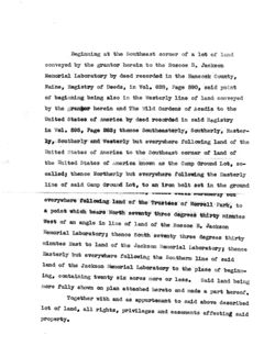
Beginning at the Southeast corner of a lot of land
conveyed by the grantor herein to the Roscoe B. Jackson
Memorial Laboratory by deed recorded in the Hancock County,
Maine, Registry of Deeds, in Vol. 628, Page 590, said point
of beginning being also in the Westerly line of land conveyed
by the grantor herein and The Wild Gardens of Acadia to the
United States of America by deed recorded in said Registry
in Vol. 595, Page 283; thence Southeasterly, Southerly, Easter-
ly, Southerly and Westerly but everywhere following land of the
United States of America to the Southeast corner of land of
the United States of America known as the Camp Ground Lot, SO-
called; thence Northerly but everywhere following the Easterly
line of said Camp Ground Lot, to an iron bolt set in the ground
wordnerly
but
everywhere following land of the Trustees of Morrell Park, to
a point which bears North seventy three degrees thirty minutes
West of an angle in line of land of the Roscoe B. Jackson
Memorial Laboratory; thence South seventy three degrees thirty
minutes East to land of the Jackson Memorial Laboratory; thence
Easterly but everywhere following the Southern line of said
land of the Jackson Memorial Laboratory to the place of beginn-
ing, containing twenty six acres more or less. Said land being
more fully shown on plan attached hereto and made a part hereof.
Together with and as appurtenant to said above described
lot of land, all rights, privileges and easements affecting said
property.
Said lot being conveyed expressly subject to all
rights, privileges and easements affecting the same.
TO HAVE AND TO HOLD the same, together with all the
privileges and appurtenances thereunto belonging unto the
United States of America for the public good and for the ex-
tension or improvement of said Park, forever.
IN WITNESS WHEREOF, I, the said George B. Dorr, being
unmarried, have hereunto set my hand and seal this
day of
in the year of our Lord one thousand nine
hundred and thirty-eight.
STATE OF MAINEL
1030.
Personally appeared the above named George B. Dorr
and acknowledged the above instrument to be his free act and
deed.
Before me,
Notary Public.
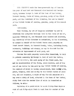
THIS INDENTURE made the twonty-seventh day of June in
the year of our Lord one thousand nine hundred and twenty-
eight, between George B. Dorr of the Town of Bar Harbor,
Hanoook County, State of Maine, grantor, party of the first
part, and the Secretary of the Interior, for and in behalf
of the United States of America, grantee, party of the second
part.
ITNESSETH:
That Whereas, by Act of Congress entitled "An act to
establish the Lafayette National Park in the State of Maine",
approved February 26, one thousand nine hundred and nineteen,
the Secretary of the Interior is authorized, in his discretion,
to accept in behalf of the United States such property on
Mount Desert Island, in Hancook County, Maine, including lands,
easements, buildings and moneys, as may be donated for the
extension or improvement of said park, and
Whereas the said property hereinafter described, is held
in private ownership by George B. Dorr of said Bar Harbor,
NOW THEREFORE, the said party of the first part, for
and in consideration of the facts, above recited, and of the
sum of one dollar to him paid by the United States of America,
the receipt of which is hereby acknowledged, does hereby give,
grant, bargain, sell and corvey to the United States of Amer-
ica, all and singular, a right of way for all purposes of a
way over a strip of land, situated in the town of Bar Harbor,
sixty feet wide the center line of which is described as
follows, to wit:-
Beginning at a point which is south thirty-four degrees
west of and fifty-eight feet distant from the center of the
Trout Brook where it Grosses the town road; thenee on a
curve to the left whose radius is seven hundred sixteen and
eight-tenths?eet and length two hundred forty-three and seven-
tenths feet; thence on a tangent south eight degrees west eight
hundred and ninety feet to a stake driven in the ground: thence
on a curve to the right whose radius is four hundred seventy-
eight and three-tenths feet and length three hundred seventy-
five feet; thence by a tangent to said curve fifty feet;
thence by a curve to the left whose radius is three hundred
nineteen and six-tenths feet and length four hundred seventy-
seven and seven-tenths feet to a point in the center of the
Trout Brook and bridge where it crosses Harden Farm Road;
thence by a curve to the right whose radius ie eight hundred
nineteen feet to land of the United States of America, forming
a part of Lafayette National Park.
Excepting,however, from the above so much of said right
of way as lies within the limits of said Harden Farm Road.
Said above described way to be used in common by the
grantee its successors and assigns, and the grantor his heirs
and assigns.
TO HAVE AND TO HOLD the same, together with all the
privileges and appurtenances thereunto belonging unto the
United States of America for the public good and for the
extension or improvement of said park, foreger.
IN WITNESS WHEREOF, I, the said George B. Dorr, being
unmarried, have hereunto set my hand and seal the day
and year first above written.
Signed, Sealed and Delivered
in presence of
-
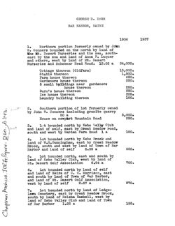
BAR HARBOR, MAINE
1936
1937
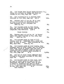
1.
Northern portion formerly owned by Join
W. Conners bounded on the north by land of
the Mt. Desert Nurseries and the sea, south-
east by the sea and land of Anna P. Luquer
and others, west by land of Mt. Desert
Nurseries and Schooner Head Road. 12.02 a
24,000.
Cottage thereon (Oldfarm)
13,000.
Stable thereon
1,500.
Farm house thereon
650.
Gardeners house thereon
250.
5 small buildings near gardeners
house thereon
250.
Burn's house thereon
250.
Ice house thereon
225.
Laundry building thereon
100.
2.
Southern portion of lot formerly owned
by John W. Conners including granite quarry
50 a
5,000.
House on newport Mountain Road
250.
3.
Lot bounded north by Kebo Valley Club
and land of self, east by Great Meadow road,
south and west by Harden Farm Road 1 a
100.
4.
Lot bounded north by Kebo Brook and
land of W.H. Cunningham, east by Great Meadow
Brook, south and west by land of Town of Bar
Harbor and land of self
5.39 a
550.
5.
Lot bounded north, east and south by
land of Kebo Valley Club, west by land of
Mt. Desert Golf Association
6.84 a
700.
6.
Lot bounded north by land of self
and land of Heirs of C. C. Morrison, east
and south by land of Town of Bar Harbor,
and land of Mt. Desert Golf Association,
west by land of self
2.67 a
270.
7.
Lot bounded north by land of Ledge-
lawn Cemetery, east by Great Meadow Brook,
south by land of Helena Haskell, west by
land of Kebo Valley Club and land of Town
of Bar Harbor
1.23 a
155.
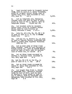
2-
8.
Land bounded north by Cromwell Harbor
Road, east by land of R. Amory Thorndike,
south by Cro mwell Harbor Brook, west by
Harden Farm Road, Deed recorded in Vol.
476, page 72
4.5 a
2,025.
9.
Lot on Ledgelawn Ave. Extension
bounded north and east by land of self,
south by land of Ora G. Strout, west by
Ledgelawn Avenue 76,860 sq. ft.
400.
10. Lot bounded north by Cromwell
Harbor Road, south by Cromwell Harbor
Brook, west by land formerly of
Mears, Morrison & Deasy 3 1/9 a
1,550.
11. Lots No. 49 & 50, 51, 52, 62 & 65
on plan of land of H. D. Joy on Straw-
berry Hill
1.5 a
550.
12.
1/2 Lot No. 3, Section B., on plan
of land of Shannon Estate, undivided and
owned in common with Augustus Thorndike
1591 sq. ft.
100.
13. Lot on west side of Otter Creek
Road, bounded north by land formerly of
Rodick Realty Co., east by Meadow Brook,
south by land of self, west by eastern
line of Notch Lot, so called 10 a
75.
14. Lot at Otter Creek conveyed by
Clifton A. Dolliver Deed recorded in
Vol. 416, page 454
16 a
160.
15. Lot No. 20 & 21 on Joy St., on
plan of land of H. D. Joy
.45
a
150.
16. Lot at Otter Creek conveyed by
Joseph E. Tripp Deed recorded in Vol.
520, page 304
5.3 a
110.
17. Lot bought from Alvah L. Abbott
on Ledgelawn Ave., , Extension bounded
north by land of self, east by land
of Phillip S. Wood, south by land of
Ora G. Strout, west by Ledgelawn Ave.
Extension, Deed recorded in Vol. 631,
Page 38
la
315.
3-
18. Lot bought from Bangor Hydro-Electric Co.,
being lot conveyed by Nathan Ash Deed re-
corded in Vol. 359, Page 295
.08 a
150.
19. Lot conveyed by T. L. Roberts Deed
recorded in Vol. 398, Page 149 1/9 a
300.
20.
Western half of lot No. 58 on plan
of land of H.D. Joy on Strawberry Hill
Deed recorded in Vol. 630, page 554
5406 sq. ft.
50.
21.
Lot bounded north by Kebo Brook,
east and south by Meadow Brook, west by
Ledgelawn Aven Extension 1/16 a
25.
House thereon
75.
22.
Western half of Lot No. 60 on Straw-
berry Hill Deed recorded in Vol. 630, Page
554.
4552 sq. ft.
50.
23. Lot bounded north by land of B.B.
Bonsey, east by edgelawn Ave., south and
west by land of self. Deed recorded in Vol.
620, page 550. 4000 sq. ft.
50.
24. Lot bounded north by road leading from
Schooner Head to Otter Creek, east by Schooner
Head road, south by quarry road and land of
U.S.A, and land of others, west by land of
self and land of others, deed recorded in
Vol. 642, page 152
57 a
2,800.
25.
1/3 lot at Otter Creek conveyed from
Richard W. Hale deed recorded in Vol. 555,
page 278
7/12 a
10.
26. Lot bounded north by town road, east
by land of self, south by land of Wm. H.
DeLaittre, and land of self, West by land
of Mabel D. McFarland and land of Heirs
of C. C. Morrison and others, Deed recorded
in Vol. 642, page 152
41 a
300.
Barn thereon
50.
4-
27. Lots no. 14, 57, & 59 on plan of land
of H. D. Joy on Strawberry Hill Deed re-
corded in Vol. 650, page 488
38,196 sq.ft.
150.
Total Real Estate Assessment
$56,695.
Household furniture
1,000.
$57,695.
Tax rate $43.80 per $1,000.
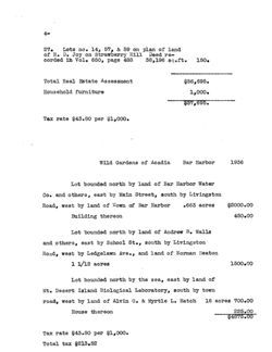
Wild Gardens of Acadia
Bar Harbor
1936
Lot bounded north by land of Bar Harbor Water
Co. and others, east by Main Street, south by Livingston
Road, west by land of Town of Bar Harbor
.663 acres
$2000.00
Building thereon
450.00
Lot bounded north by land of Andrew B. Walls
and others, east by School St., south by Livingston
Road, west by Ledgelawn Ave., and land of Norman Beaton
1 1/12 acres
1500.00
Lot bounded north by the sea, east by land of
Mt. Desert Island Biological Laboratory, south by town
road, west by land of Alvin 0. & Myrtle L. Hatch 16 acres 700.00
House thereon
225.00
$4875.00
Tax rate $43.80 per $1,000.
Total tax $213.52
Dor Property host: Uniated.
Page
Ash, N. & S.
471-120 West of Ledgelawn Ave.
Extension
52
Ash, N.
471-124 Easements on Ledgelawn
Ave. Extension
58
Bowen, P. W.
464- 40 Near Catholic Cemetery
44
Bates, S.W. & F.C.
476- 72
Cromwell's Herbor Road
West of Morrison
63
Bates, S.W. & F.C.
476-280
Cromwell Harbor Road &
Kebo Street
81
Brewer, F. L.
480-268 East of Ledgelawn Ave.
Adjoining Abbott
64
Conners, F. & A.E. 473-527 25 Acre West side Lake
(Burleigh lot)
79
Conners, A. E.
514-374 Part No.6 West of Eagle
Lake
117
Conners, J. W.
517-411 Dis. of 472-267
131
Derby, H.
357-331
Dove Field
9
Dorr, Mary G.
377-167 Will
10
Deasy, L.B.
500-153 Corner Waldron & Glen
Mary Road
100
Deasy
500-325 Cedar Lane
101
Fox, H.
475-264 3 sore West side Lake
(Burleigh Lot)
80
Greeley, M. A.
473-396 931 acre lot West side
Lake
76
Harvard College
435-363 Vote
26
"
"
-357 East side Schooner Head Rd. 27
Higgins, B. S. Trustee471-252 Cemetery Lot W. of Ash
purchase
59
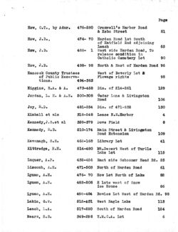
How, C.T.by Admr.
476- 72 Cromwell's Harbor Road
West of Morrison
63
Page
How, C.T., by Admr. 476-280 Cromwell's Harbor Road
& Kebo Street
81
How, J.B.,
474- 70 Harden Road 1st South
of Hatfield 2nd adjoining
Leach
65
How, J.B.
488- 1 West side Harden Road, To
release condition in
Catholic Cemetery Lot
90
How, J.B.
498-
98 North & East of Harden Road 96
Hancock County Trustees
West of Beverly Lot &
of Public Reserva-
Flowage rights
95
tions.
494-363
Higgins, E.A. & A.
473-458 Dis. of 214-261
129
Jordan, L. H. & A.E. 500-308
Cedar Lane & Livingston
Road
106
Joy, H.D.
481-254 Dis. of 471-232
130
Kimball et als
318-248 Lease N.E.Harbor
4
Kennedy,J.S.et al
359-379
Dove Field
8
Kennedy, E.B.
510-174 Main Street & Livingston
Road Extension
109
Kavanagh, S.E.
462-168 Library Lot
41
Kittredge, R.H.
514-480 Mt.Desert West of Turtle
Lake Lot
115
Luquer, A.P.
432-456 East side Schooner Head Rd. 25
Liscomb, A.E.
471-503 North of Harden Road
61
Lynam, A.H.
476- 70 How Lot North of Lake
82
Lynam, A.H.
482-208 2 lots west of Snow
Ice House
86
Lynam, A.H.
498-484 Bowles Lot West of Harden Rd. 98
Lakin, G.W.
512-401
West Eagle Lake
113
Leach, L.A.
517-220 South of Harden Road
124
Mears, E.B.
349-298 Y.M.C.A. Lot
6
Mears, E. B.
349-311 Y.M.C.A. Lot (Lease)
7
If
"
409-442 Lease Y.M.C.A. Lot
20
17
"
"
500-153 Corner Waldron & Glen
Mary Road
100
17
500-325 Cedar Lane
101
Markoe, M.C.
454-535
Grantor only
32
"
"
454-537
Way East of Schooner
Head Road
33
"
If
F
454-543
2 lots east of Schooner
Head Road
34
Mt. Desert Nurseries
454-537
Way East of Schooner
Head Road
33
Moran, A.E.
473-390 931 aore lot west side Lake 75
Morrison, C.C.
479-473
South of Morrison Farm Eden 89
IT
11 "
500-153
Corner Waldron & Glen
Mary Road
100
Morrison
500-325
Cedar Lane
101
Morrison, C.C.
514-390
Turtle Lake lot & two on
Sargent Mountain
122
Maitland, A.
424-102 Dis. of 367-283
127
Norris, C.H.
402- 6 Equity Suit High St.
21
"
#
"by A.H.Lynam 400-508 High Street
22
Norris, C.E.
400-511 High Street
23
Roberts, W.M.
286- 7 Adjoining Zena Brewer
Otter Creek Road
1
"
"
289-133
Part Zena Brewer Lot
Otter Creek Road
2
11
If
"
294-465
Otter Creek Road near Park
3
If
FT "
471-126
Beverly Lot
46
If
" "
475-229
1000 A. East side Lake & Lot
West of Turtle Lake
68
Roberts, W.M.
509-378 49-50-51 & 52
Strawberry Hill
83
If
" "
514-387 No. 1 West of Eagle Lake-
Railroad Lot-adj. R.R.
Lot with way
119
Roberts, WMM.&T.L.
512-
35 West of Otter Creek Road
111
"
T.L.
318-449
Lease Main & Stephen Lane
5.
Rodick Realty Co.
438- 13
Agreement-Adj. J.B.Hadley
28
"
- 18
"
" Main St.
29
Adj. School St.
"
11
- 20 Leach Lot Harden Road
30
"
"
446- 18 Lease West Side Main St.
31
"
"
11
"
483-325 Leach Lot South of Harden Rd. 94
Rodick, A.S.
472- 65 Livingston Lot or No. 57
48
Rodick, F.
472-100
Part of Strawberry Hill
51
Ralph, T.P.
477- 96
West of Ledgelawn Ave.
South of Cemetery
85
Roman Catholic Bishop 488- 3 Part of gemetery lot,
92.
Rich, F.M.
500-332 West of Ledgelawn Ave.
Livingston Road
105
" J.H.
318- 30
Eagle Lake Road
125
"
no
415-407 Adj. S.N.Emery Dis.by
480-12
126
Sherman, G.
386- 50 Lot adj. Ogden - East side
Schooner Head Road
18
Stalford, J.H.
480-268
East of Ledgelawn Ave.
adj. Abbott
64
Stebbins, G.L.
482-206 West of Turtle Lake
78
Smith, H.V. & H.D.
5105524
West of Otter Creek Road
110
Silk, M.R.
512- 35 West of Otter Creek Road
111
Tripp, J.E.
500-332
West of Ledgelawn Ave.
Livingston road
105
United S. I. Co. of N.J.
430-331 Dis. of 403-216 128
Weston, C.P.
474-246 1000 A. lot East side Eagle
Lake - Lot No. 5 West side
Lake - Part of No. 44
72
Whittaker, E.K.
500-329 Adjoining Cedar Lane
103
" "
500-332 West of Ledgelawn Ave.
Livingston Road
105
" "
500-338 Adjoining Cedar Lane
107
quick
&
A. H. Liguam
David 1. Rodick
Affartreys and
Commerlors
super
Serenas B. Rodirk
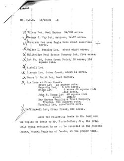
Bar Harbor, Maine, October 10, 1929.
Mr. Charles 0. Heydt,
26 Broadway,
New York, N.Y.
Dear Mr. Heydt:
Things have been moving so rapidly the
past few months that I have been unable to forward the
abstracts of title and deeds of the various lots we have
been working on, but now I am able to get them together
and will forward to you by express the following abstracts:
Eno Lot at Otter Creek
How Lot near How's Park, 80 acres.
Henderson Lot near Duck Brook, 26.8 acres
M. Carey Lea near Duck Brook, 10 acres 39.06 rods
Salisbury Lot near Duck Brook, 46.4 acres
Deasy et als, West side of Otter Creek Point about
25 acres.
Harden Farm Lot near Kebo Mountain, about fifty
acres.
Hutchings Lot near Kebo Mountain, 6 acres.
Hasket Derby Lot near Schooner Head, 72-139/150 acres
Roberts Lot near Otter Creek Point, 49.13 acres.
Griswold Lots near Seal Harbor, Maine.
&
Rodick
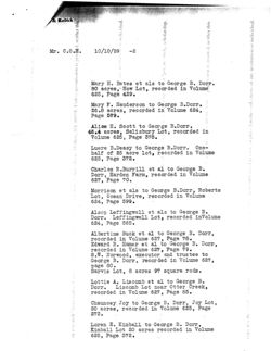
Mr. C.O.H. 10/10/29 -2
Wilson Lot, Seal Harbor 54/100 acres.
George J. Joy Lot, Asticou, 14.07 acres.
Morrison Lot near Eagle Lake about seventeen
acres.
Walter L. Stanley Lot, about eight acres.
Millbridge Real Estate Company Lot, five acres.
Lot No. 86, Otter Creek Point, 50 acres, 132
square rods.
Kimball Lot.
Liscomb Lot, Otter Creek, about 14 acres.
Henry L. . Smith Lot, Seal Harbor.
Six Lots at Otter Creek.
Bracy Lot 18 square rods.
Hagerthy Lot,
1 1/6 acres.
Stone Lot
2 acres 66 square rods
.212 acres.
John F. Young Lot 40 square rods
If
about
18x160
Bar Harbor Banking & Trust Company,
Trustee, two hundred rods.
Turnbull Lot, one-fourth acre.
X
Leffingwell Lot, Otter Creek, 220 acres.
Also the following deeds to Mr. Dorr and
the copies of deeds to Mr. Bookefeller, Jr., , the orig-
irals being retained by me 30 be recorded in the Hancock
County, Mainek Registry of Iseds, at the proper time.
& Rodick
Mr. C.O.H.
10/10/29
-2
Mary H. Bates et als to George B. Dorr.
80 acres, How Lot, recorded in Volume
625, Page 429.
Mary F. Henderson to George B. Dorr.
26.8 acres, recorded in Volume 624,
Page 579.
Alice H. Scott to George B. Dorr.
46.4 acres, Salisbury Lot, recorded in
Volume 625, Page 378.
Luere B.Deasy to George B. Dorr. One-
half of 25 acre lot, recorded in Volume
625, Page 372.
Charles R.Burrill et al to George B.
Dorr, Harden Farm, recorded in Volume
627, Page 70.
Morrison et als to George B. Dorr, Roberts
Lot, Ocean Drive, recorded in Volume
624, Page 599.
Alsop Leffingwell et als to George B.
Dorr. Leffingwell Lot, recorded inVolume
624, Page 565.
Albertine Buck et al to George B. Dorr,
recorded in Volume 627, Page 78.
Edward B. Hamer et al to George B. Dorr,
recorded in Volume 627, Page 79.
S.W. Norwood, executor and trustee to
George B. Dorr, recorded in Volume 627,
page 80.
Sarvis Lot, 8 acres 97 square rods.
Lottie A. Liscomb et al to George B.
Dorr. Liscomb Lot near Otter Creek,
recorded in Volume 627, Page 85.
Chauncey Joy to George B. Dorr, Joy Lot,
20 acres, recorded in Volume 625, Page
273.
Loren E. Kimball to George B. Dorr,
Kimball Lot 20 acres recorded in Volume
625, Page 372.
Rodick
Mr. C.O.H.
10/10/29 -4
James H. Smallidge to George B. Dorr
Smallidge Lot, 20 acres, recorded in
Volume 625, page 116.
Hemenway to George B.Dorr, 241 acres,
recorded in Volume 625, Page 179.
Swift Riche to George B.Dorr,
Riche Lot, recorded in Volume 625,
Page 307.
Copies of deeds from George B. Dorr, as follows:
How Lot.
Henderson Lot.
Salisbury Lot.
Deasy Lot.
Harden Farm Lot.
Roberts Lot.
Leffingwell Lot.
Sarvis Lot.
Liscomb Lot.
Joy Lot.
Kimball Lot.
Smallidge Lot.
Hemenway Lot.
Riche Lot.
I am also enclosing therewith the original deed from Clara
E. Dyer to John D. Rockefeller, Jr., recorded in Volume 625,
Page 263, being the Dyer Lot at Seal Harbor, Maine.
Very truly yours,
Addrian
Table 5/29/03
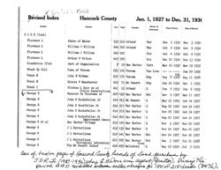
Revised Index
Hancock County
Jan. 1, 1927 to Dec. 31, 1936
Grantor
Grantee
Vol.
Page
Nature of
Location
Date of Deed
Date of Record
Instrument
DORR (Cont)
Florence L
State of Maine
632
316
Orland
War
Dec
1 1930
Dec 3 1930
Florence L
William J Willins
646
202
Orland
War
Oct
4 1934
Oct 9 1934
Florence L
William J Willins
646
202
Dis
Oct
4 1934
Oct 9 1934
Florence L
Arthur F Wilson
645 556
Dis
Dec 12 1934
Dec 13 1934
Foundation (The)
Cert of Organization
5
19
Bar Harbor
Cert
Mar 16 1935
Mar 19 1935
Frank By Coll
Town of Verona
653
106
Verona
Tax Lien
Jun 29 1936
Frank E
Ack
John E Witham
622
172
Verona
Mtg
Sep 8 1928
Sep 11 1928
Frank E
Minnie F Manchester
629
71
Mt Desert
Mtg
Jan 14 1930
Mar 1 1930
Frank I
Clinton L Dorr et al
641
13
Orland
Q
Jun
5 1933
Jun 6 1933
Public Reservations
George B
Hancock Co Trustees of
607
439
Bar Harbor
Rel
Mar 9 1927
Mar 11 1927
George B
John D Rockefeller Jr
614
513
Mt Desert
Q
May 12 1923
Oct 14 1927
George B
John D Rockfeller Jr
614
517
Bar Harbor
Q
Sep 22 1922
Oct 14 1927
George B
John D Rockefeller Jr
614
519
Bar Harbor
Q
Nov 25 1922
Oct 14 1927
George B
John D Rockefeller Jr
614
520
Bar Harbor
Q
Sep 22 1922
Oct 14 1927
Improvement Assoc
George B et al
Bar Harbor Village
619
129
Bar Harbor
Q
Nov 3 1927
Nov 22 1927
George B
J L Ketterlinus
619
139
Bar Harbor
Q
Nov 14 1927
Nov 26 1927
George B
J L Ketterlinus
619
141
Bar Harbor
Rel
Nov 14 1927
Nov 26 1927
George B
J L Ketterlinus
621
592
Bar Harbor
Rel
Dec 3 1927
Jul 21 1928
Biological Laboratory
Cove
George B
The Mt Desert Island
624 459
Salisbury
Q
May 15 1929
Jul 5 1929
One of twelve pages of Hancock Cerentz Records of land purchases by
J.D R (1927-1936) where G.B.Dorr was agent (grantos) Duraof the
period GBD mediated between seller +buyer for 185 of 215 deeds (85%).
281
know all men by these presents that Henry
be I prove of Buckefort Hancock bounly
Book
State of mame in considezation of thrie thous-
and dollars paid by George B. Dow of Boston
167
County of Suffolk Commonwoalthy of massa.
chuselle the receipt whereof D do hereby acknowl-
edge, do hezeby remise release, bargain sell
t convey t forever guit-claim into the said
George B. Dow & his heirs forever
rejaliom
a certain parcel of land near Bar Harbor
in the town of Edew Hancock County State
ming at Jajon Wasgalle Easterly lino at a cedar
of miami described acfollows, to with Begno-
stake thence South 49° East hirrity even
rode to Charles Bunker's Westerly lino- thence
links to Hannah Gracis line= thence South
South 150 West forty-tiro rods and thirteen
800 West to a brich his at the Heighway = shence
on the highway now called the Schooner Head
road Northerly forty-six rode to Jason Waegaller
corner found = therce on said Waegally
by lino north 20° Eact Eleven node to the place
of begmining = containing six & one half acres
more or less meaning howeverto convey
all the land conviced to me by Daniel
Hinckley by his deed dated , uly a.D. 1879
& recorded in the Registry of Deeds for Hancock
County you 164 folio 418 to which deed and
record reference may be had
made by me for seven hundred & fifty dol.
the eaid primieis are subject to a mortgage
lane to said Hinckley dated July ft a.L. 1879
recorded in said Registry Vol.16st Jolis 274
which said mortgago its accumed and is
to be paid by said D on all part of the con-
sideralino named in shedeed
to have t to hold the same, together with
all the privileges and appurlence there-
unto belonging to him the said George B.
Dow his heirs acergins forever. and 2 do
covenant with the said grantie here and
assigns that & will warrant & forever defored
the premises In him the eard grantee his
heirs t assigns forever against the lawful
282
Book
claims t demrude of all persons claming laming
167
by through or under me or their except
In those Witness claiming under D the said morlgago
Wherez said granfor and
Edna P Sprowl wifo of the said H enry b.
I browl no lilimony of her relmequehment
of her night of dowed in the above described
premiers have hereunto Ret our hande and
our Lord one thousand eight hundred &
Peace this must day of October in the year of
severly nine
Signits sealed tdelui
ered in pricence of
Henry le Sprowl(L S)
La. Empryth He b.8.
Ednah B. Sprowl(LE.)
J.a. Hearman LOEB.S
Hancock RR Oct. 9"1879- then personally
State of waine
and acknowledged the above milliment to
appeared the above named Henry b. Spring
to be his preaced deed
Before me
G.A. E mery
Justice of the Peace
Rec'd Oct by
W.B. bampbell legin
229
know all men by these Presino. That 2. Charles 2.Dorr
of Boston in the borna 7.8 inffock in the commonwealth
of massachusets. in consideration. of one dollar. and
Book
ch
said Boston, single Gentlewoman and by Rehartes milling.
other valuable considerations. to me. paid by Lency Ellis of
169
and Chanman Biddle both of the City and County
Philodeephia. in the commonmeauth of Pennsylvanit Trusties
of the estate which was formerly of Milliam Binghane the
Eidir. deceased the receipt where of I do hereby acknowledge do
11/29/1979
hereby give. grant bargam. sell and convey units the said
buen Corlis. and her hurks and assigns and is all others for the
time being owners. or rightful occupants of all or any paro
of a certain parcel of land, now of 2ara lency belis, erimate
in oden Reancock County and State of mame:
Bino ham estate. and west. by land of said Dorr. forever
Bounced mouth and bast. by the sea. south by land of the
as appurtenant to all and every part of her said parcel of
land, and into she said charles milling ant bhapman
Biasie and their herrs. and assigns. and their successors in
said arest. and their hurs and assigns and to all others for
the time being owners or occupants, 5 all or any
part of a certain purcel of land. now of said Trustees
situate in Bden. Bounand north by land, of said Eucy bilis
East by the 2a. South lr Bear Brook and west by loma of
said Darr. forever us Insurtenant to all and every paro of
their said parcei of last herein mentioned. a rights of may
over and across the land of said Dorr. to and from the
highway known and called the Schooner Nead Road.
So lich know hereby granted being particularly located
and described as follows: that is is say, Beginning on
the East side of said highway called the Schooner Head Road
ar the South west corner of a cottage of said Dorr and
thence rumning following the avenue of said Dorr as now
built first South 742 East. eight and three fourth roas to the
west line of the Sherman boo DO called. thence south 41% East
give roals, thence South 51 % East five rode, chance south 62 4
east two rods, stance south so East five rode, thence
South 5442 East mine and three fifths roas to the west line
of land of sara Dorr which line is the Bags line of the said
Sherman Love thence South 67 4 East three rocks, strence
south five rods. thence South 48's" casr
ten roals. thence South 5-03/44 East. (diverging from the main
avenue of said Dorr) four road to a stake, thence South 264:
East twelve rods thence south 464: East six and three
fourths roels. thence South 29: Dass three roals. thence
230
South 814.4 East four rode. and seven links, thence
south 50 12% East your roue and sevenian links thene
Book
South 54% East four roas. stance South 58k: East
169
two roas thence South 88 East two roae. thence north
S1: Saso. two roces thence north 714 East ins roas. to the
point of a ledge. chence South Sq 1/2" East two roces, thence
South 73% East two roces ts a stake. etre said may
from it2 place 5 beginning to this last herein mentioned
stake, to be twenty feet wide. strence south 53kg East
one red to a stake on etre west line of said land of said
Euch Sllis:- the said way at this place to be thirty feed uncle,
The line herein above discribed by its several coveres
distances and monuments from said Schooner bead Road
ts the said west line of land of said Lengy Ellis to be the
centre use of the hereby granted. The courses herein
before named are courses, but there are courses
between the points herein before given and sand way, is
a curving way, running through said points hereon before
named- For further identification of said way hereby
grantic, reference may be had. to a plan of said way. made
the E. M. Camor. surveyor from his survey of the same
made September 18th a.D. 1879. said plan being dated Sepo
13-187P marked 2." and eigned by said E. on %amor. and
herewith to be recorded: the way hereby granted being
marked on said plan in red ink which said way here-
oils and her here and assigns and all said ownere
by granted shall be held inderjoyed by the said Eacy
is all and every hars of her said parcel of land. that is
for the time being of her sard harcel of land as appurtenant
to say, the pascel fires herein before described forever, and
be the said leharlee milling and Chapmon Bradle. Trustees
all 200'l outer owners. for the time being of their said
as aforesaid, their sovil successors. here and assigns. and
parcel of land as apportenant to all and every part of their
said parcel of land. thus is to say. of the parcel secondly
herein-before mentioned and described forever. to the full
calent and with the same rights thereto as if the said
way hau been only and legally laid our and established
as a private way for and to and from said parcels of
land, is and from said highway called the Schooner Nead
Road by the proper officers and authorities under the Status
of the Stale of manie. the way hereby granted being a
Substitute for and insteau of a way Heretofore so laid
our and established and which is-hereby excepting and
reserving is each and all of said grantees her. his and
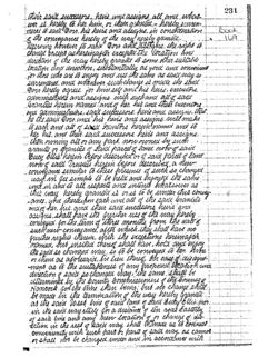
231
their said successore. here una assigns all and what-
ever is hereby to her. him. or them antia. - hereby surren-
deral to said Dorr. his here ana assigne in consideration
Book
of the conveyance hereby of the way nereby rive aya grented
169
Receiving however to said Dorr and assigns. the right to
change except ashereinafar excepted the location ance
direction of the way hereby granted to some. other suitable
location and cirection substantially as yood and convenient
surrendered. and whenever such is made the send
for those who are is enjoy and use the same as said may so
gorr hereby agrees. for him self and his here. executors.
administration and assigns. with euchand all of said
Granties herein named and of her. his ana their executive
and Daministrains, said successore. here and assigns. that
he the said Dorr. and his here and asergies will make
to each and all of said Gramtors herein named and to
her his and their sand successors. here and assigns.
then owning all or any part now owned by such
granter or granties of end parcel of land. now of said
Bucy Ellis herem before discribed or of said parcel of lama
now of said Trustees herein before described a new
conveyance similar to these presents of such so changed
and in and to all respects and intents whatsoever as
way. in fee simple to be held and enjoyed the same
-once and thereupon each and all of the said Grantees
this way hereby granted is or is to be under this convey.
and of her. his and iteur said successors here and
assigns shall have the furituer use of the way hereby
conveyed. for the term of three months from the date of
such new convey once, after which they shall have no
gurether rights therein with the exceptions hereimafrin
named, bus instead thereof shall have, hold and enjoy
the said so changed way. is to be conveyed to her. him
or item as aforesaid, in lieu thereof. 2th case disagree-
-ment as to the suitableness 07 any proposed location ana
direction of said so changed way, the same shall be
determined by the bounty commissioners of the Bouning
Hancock for the time then being but no change shall
be made in the termination of the way hereby granter
as the said West line of waid land of said buty lis. nor
in the said way itself for a distance of ten road Easterly
of said line and any new location of or change of dis-
ection in the rear of said way shall be made as is connect
or shall not be changed under. and in accordance with
convenuently with such hars or harts of said way as cannot
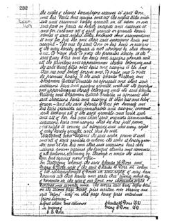
232
the right 3 change herein before reserved to said Dorr,
and his heirs. and assigns and all the rights tilles inter-
Book
169
esls and easements hereby granted. in. is. upon or over
Dara hard or parts as herely exceptial and reserved, is,
named of said rights. tiltes, interests and easemenisand
and for. each and all of said grantie or granties herein
to and for his her. and their said successors. heirs. and
assigns. - The use by said Dorr or his heirs or assigns
of its way hereby granter is not ubridged by. this courry-
-ance- So Have and To Hold. the premises hereby. to the
said Lucy Ellis and her herrs and assigns grantia with
all the privileges and appartinances thereis Eelonging anio
the said Laucy Sellis. and heirs and assigns to htr. and
their use. and behoof forever. and, To Have. and To Hold
the premises hereby to the said Charles Willing and
Chapman Biddle Trustees as aforesaid and their said
successors. heirs and assigns granted with all the privileyes
and appurtenances thereis belonging into the said Charles
nilling and Chapman Biddle Trustice us afresaid their
sand successors heres and assigns to their use and behouf
forever - and the said Charles 1.2 orr for himself and
his heirs execulors. administrators and assigns. covenants
with eachand all of the said grantees. and with each
and all of her. his and their said executors administrain
successors. hurs and useigns that he has full power.
and right is convey as aforesaid caid and every right
of way hereby granted and thus he will,
warrant and Defence the said right forever to each
-tea and to her his and their said successors hurs dirtck
and of said granters is whom the same is herebygran.
assigns forever against the langue clamins and demands
of all persons, claiming by. through or under the said
Corr. but against none other-
mary G.Dorn wife of the said b harles H. Dorr in token
In Testimony whereof, the said Charlee L.Dorr. and
of her relinopiestoment of Power. in said right of may. have
hereunis ser their hands. and seals this
of november in the year of our Lord. one thousandeeight
hundred and seventy mine. the words said Bucy before Eastes
on the second page hereof. first written over erasure and
said "before" "way" on this rage hereof first interlined
before signing-
Signed sealed. and delivered
Charles? H. Dorr (CS)
in presense
B. Dorr
mary G.Dorr (68)
233
commonweala of massachuseus. suffock 8S.
Boston of any 28-00 1880.
Then personally appeared b harlee b Dorr above manned
and acknowledge the foregoing instruments. by him
Book
signif and sealed. to be his free acr and aread.
169
before me.
Charlee 0. Bowaitch
justice of the Peace.
Reca Jany 24-1880-D 6.hP. om 9 entered by,
o. B Sampbell
Regr.
Know all men by these Presents. that we Charles
Willing, and S hapman Bioddle both of Philadelphia in the
commonwealth of Pennsylvania, Trustees the Estale
formerly of Milliam Bingham the slow deceased, in
consideration of one dollar. have by Jency blue of Boston
commonerealth of massachusetts. The receipt where of is
hereby acknowledged do hereby release remise sell. and
forever quit- clam unto the said Leucy Ellis and her hurs
ana assigns forever. a certain hart of the way reserved in
our fortner need. to said Lucy Ellie dalea Feby 5 D.D. 1877
and recorded in the bancock county Registry of Deeas in
the state of mame we 156 folio 243 to wib: all that
haro of said way which his is the Eastward of the may
this day conveyed to we by the deed of the said bucy
ollis. and lard out by 8. an. Lamor surveyor. to which
deed, reference may be had. and also all right titles
interest and easements of us, or of either of us in or to said
hart herem released so that all the way the said Trustees
their successors. or assigns shull have upon and acrose
the land of said Ency Ellis named in 2010 weed. 8 Relys-
327
know all men by there Presente, That
Book 324
He George. B. Dorrand mary, G. Dorr both of Eden,
toounty of Hanever, State of maini, in concide
eration of the rum of One Dollar and other
5/8/1898
vuluable considerations perich by The
mount Decert nurcerier, a corporation
organized under the lawe of the Suite of
maini, and having itc location at Bar
Harbor in evil town of Eden, the re cercipt
hereby give grant bargam cell nd convey
whereof we do hereby acknowledge, do
unte the could The mount Decert nurcerier
itc arrignie forever, a certain
lot or parcel of land cilluated at Beer
barbor in caid town of Eeden, bounded
and described are follow
Reginning at w alone bound ut in
the ground on the eartern ride of the
Schooner Head Road and in the south-
from said Schooner Head acred to land
weekern side of a private wry leading
formerly of Lucy Ellin now of Luquer
thence by the following
but everywhere following the southwestern
line of said pervate way, caud line
being marked at each angle thereof by
cline bounch cet in the ground, to wit :
Firet South thirty four degreen twenty
minuter eact Rixly eight and five tenthes
feel thence coultr forty five reguer
forty five minicler eact eighty nine and
three tenthe feel: thence south forty
eight degreen each three hundred and
libenty four feet : thence couth forty
degrees fifteen miniter eact eightly eight
and six tenthe feet thence with forty
nini degree eact forty eight feet thence
couth eighty degries forty find minutee
328
Book
eact one hundred ninity three and thirty five
324
one hundredehr feet thince south cixty
elegrue forly - five minuter eart four hundred
and forty feet to a alone bound set in the
ground in the southwestern lini of said
previte way; thence leaving said friendly
way and running first with seven
degrees forty five minuter weet livelve feet:
thence south sixteen degrees forty five min
uler weet lin feet to a clone bound act in
the ground : thence couth twenty eight
degreen weet tin feet thence couth thirty
four degreen evect lin feet to a alone
bound set in the ground : thence south
forty one regreen forty minuter west len
feet thence south fifty degreen len min-
uler weet twenty feet to W alone bound
set in the grinind chence couth cirty
degreen thirty mindeter weet twenty fut:
thence with evenly one degreen fifty
minutee west twenty feet to a stone bound
set in the ground shence aruth seventy
six dequer forty five minuter west fifty
feet to a clone bound cet in the ground:
chine south sevenly one degree forty five
minister west fifty feel thence south sixty
three degreen thirty five minutes weet
twenty five feet thince couth fifty Rix
eleguir five minuter week livety five feet
to a clone found set in the ground thence
south fefty two degreen forty minister week
liventy five feet thence with forty three
feet to a alone bound ground
elegrier fortly minules event twenty five
thence routh thirty five degreen thirty five
minuter weet fifty feet to a alone bound
act in the ground : thence south thirty
two degrees twenty minutes west one
hundred feet to a clone bound set in the
ground: thence south thirty two degrees
Book
leventy five miniller weet one hundred
324
feet to a alone bound set in the ground:
thence south thirty thus elegries thirty
minicler west one hundred feet to a stone
bound set in the ground thence south
thirty five degree thirty minicler weet
one hundred feet to a alone bound set in
the ground: thence with thirty two
degrees weet one hundred feet to a stone
bound set in the ground thence south
thirty degrees fifteen minicler weet one
hundred feet to a clone bound set in the
ground : thinca south twenty eight degrees
weet one hundred feet tow clone bound
set in the ground! thenet south thirty
degrees thirty miniles west seventy five
feet to W stone bound set in the ground,
thence couth thirty one degree weet sixty
feet to W alone brund set in the ground
thince couth forty nine degreen forty find
minutin evect twenty five feet thence
with cirty nine Elegrin west twenty
five feet to avelone bound set in the
ground: thence south seventy six degree
forty five minuter west twenty five feet
thence south eighty five degries forty
Ivi minutes west twenty five feet
thence north eighty eight degrue fifteen
clone bound set in iht grund:
minuter weet twenty five feet to a
chence north eighty one degreen forty
five minuiler weet one hunched forty
friends twenty five one hundredthe feet
to W clone bound net in the ground
in the euclem cide of said Schooner
Head avail : thence on same cource
330
Book
twenty seven and seventy five one hundredth
feet to the center of could Sehbonevileead Road :
324
thence by the following course und dictance
Head Road, to wit: Furch north rix degrees
but following the center of caid Schooner
fifty minutes wert fifty feet thenei north
eleven degrees lin miniller weet one
hunched feet thence north nmi elegree
twenty minuter west one hunched feet
thence north seven degreen thirty minuter
weet fifty feet; thence north five degrees
thirty minicler weet-fifty feet : thence north
fifty minuter each one hundred feet :
chence north four degreen thirty minuter
east live hunched feet thince north
four degreen excet four hunched feet thence
north thirty five minuiler each seventy five
feet: thence north fifty minuter eact
three hundred feet thence north three
degrees fifty minicler went two hundred and
fifty eight feet to a point in the center of
cuid Schooner head Road bearing north
thirty four degreen twenty minutes weet
and illiant forty ciy and five unthe fut
from the pirnt of beginning thiner couth
thirty feer degrels twenty minister eact
forty six and five lenth feet to the point
of beginning, containing twenty and two
lenthe acrer (20.2) were moreor lear together
with all buildings thereon
fit plan horn, 16 a
Dung the came lot of land shown upon
plan of the same made by Edgar, d, Lord
6.6, dated may 2nd 1898 and to be recorded in
the Hancock bounty mami Registry of Dude.
To have and to Hold the afriquented and
burgarnich premium with all the privilegeer
and apprelinance thereof to the said The
mount Decert nurceive ite successore and
331
arrigns, to its and their use and behoof forever,
and we do covenant with the said
Granter, its successors and arrigni, that
Book
we are lawfully surged in fee of the premium
324
that they are free of all
that we have good right to cell and comeg
the same to the could Counter lo hold as
aforeard ; and that we and our herie
shall and will warrant and defend the
same to thereich mount Decert manevie
itc successors and accigne forever, against
the lawful claims and demande of all,
personal excepting however from the
operation of the covenante herein contained
all rights of the lown of Eclen and of the
Schooner Head Road included with the
public mand to challpart of the
boundavir of the lot herein decribed as
conveyed
In theness thereof He the said Ganlon,
both buring unmarried have hereunto set
our hundre and reale this fifth day of
may in the year of our Lord one thousand
tight hundred corld munity eight
signed realectinal delivered
Blanchedrine, Brackett acto
in pricence of
both
George B.Doss. (L.S.S
arthur, R. Torrey.
mary G. Dass, (LSS)
State of marrachurette se
bounty of Sufform, bity of Boeton
Be it remembered That on hir Sixth
day of may in the year one thousand
eight hundred and ninety eight, before
me arthur, a. Jorrey a Commiccioner of the
State of maine, recident in the State of
morrachurite, personally came and
appeared the within named George B
332
Dorrind mary G Darrand reverally acknowledged
Book
the within annexed inclument in witing
324
to be their free and voluntary act and dud
In Witness thereof & have hirunto set my
hund and affirial my official real at
my offici no. 23 Dourt Sheet, in the bity of
Becton, in the bounly of Suffock and State of
Marrachunetter, their 6th day of may a.D.
QD
eighteen hunched and ninety Eight.
arthur, R. Torrey.
Commicioner of the State of maine,
Reed may 9,1898 at8 h 30 m am. and entered
by Mebampbell, Reg.
Know all men by there Presents, That I
Benjamin, L. bondon of Penobecot in the bounty
of roancock and State of maine, in/conrideration
of Eight hundreds forty six Dollars paid by
Rachel, D, 26, michole both of
Town bounly and State aforeaid, the receipt
whereof d do hereby acknowledge, do hereby
give grant burgain all and convey unto
the end Ruchel Dind mary so mehole their
here and arrigns forever u certain lot or
parcel of land situated in Penobreat afore
card and boundectire decersbed as follow:-
Beginning on the southern line of the
homerliced of Prince 96. Stapler two hundred
and twenty feet easterly of hie southweet
corner: thence following said Stapler line
eacterly one hundred and thirty eii
feet to a clake: thence at right angler
474
BOOK 681
KNOW ALL MEN BY THESE PRESENTS,
11-131
THAT the Bar Harbor Banking and Trust Company a corporation organized and
need 156
existing under the laws of the State of Maine, and located at Bar Harbor,
Hancock County, Maine, owner of a certain mortgage given by George B. Dorr of
said Bar Harbor, to the Bar Harbor Banking and Trust Company dated March 30,
A. D. 1940, and recorded in Hancock County, Maine, Registry of Deeds, Book
672, Page 101, does hereby acknowledge that it has received full payment
and satisfaction of the same, and of the debt thereby secured, and in con-
sideration thereof it does hereby cancel and discharge said mortgage, and
release unto the said George B. Dorr, his heirs and assigns forever the
premises therein described.
IN WITNESS WHEREOF, the said Bar Harbor Banking and Trust Company has
caused its corporate seal to be affixed, and these presents to be signed in
its name and behalf by R. E. McKown its Treasurer this third day of January
)
A. D. 1942.
SIGNED, SEALED AND DELIVERED
IN PRESENCE OF
BAR HARBOR BANKING AND TRUST CO.
Louise Leland
By R. E. McK own
Corporate
Treasurer
Seal.
STATE OF MAINE
Hancock ss., Bar Harbor Jan. 3, 1942 Then personally appeared the above
named R. E. McKown Treasurer of Bar Harbor Banking and Trust Company and
acknowledged the foregoing instrument to be his free act and deed, and the
free act and deed of said corporation, before me
Notarial
Linwood Mayo
Seal.
Notary Public
Rec'd Jan. 3, 1942, at 1h. 20m. P.M., and entered by,
George R. Hadlock, Reg'
KNOW ALL MEN BY THESE PRESENTS, THAT I, George B. Dorr, of Bar Harbor,
G81/474
Hancock County, Maine, in consideration of the sum of thirty seven thousand
five hundred dollars, paid by the United States of America, the receipt
478
whereof I do hereby acknowledge, do hereby GIVE, GRANT, BARGAIN, SELL AND
CONVEY, unto the said United States of America and its assigns forever,
eight certain lots or parcels of land situated in said Bar Harbor, Hancock
County, Maine, and bounded and described as follows, to wit:
U.S.I.R.
LOT NO. 1. Beginning at the corner of land formerly of Harvard University
Stamps
and Anne Pierrepont Luquer on line of land of the grantor herein, marked by
$41.25
a stone post and iron polt;thence North twenty one degrees and fifteen min-
SERIES
utes East four hundred and forty seven feet following boundary line between
1941
said grantor herein and Luquer to a stone post set in the ground on said
Canceled
line and at the Southerly and Easterly line of right of way granted by C.
H.
1/3/42
Dorr to Lucy Ellis; thence on said course fifteen feet to the center line
G B D
of said right of way; thence South twenty four degrees and thirty minutes
X
East along center line of right of way granted by Lucy Ellis to Matilda C.
Markoe, twenty-two and three tenths feet to a point sixteen and five tenths
feet distant from the last mentioned stone post, and at right angle to said
Dorr and Luquer line; thence South twenty one degrees and fifteen minutes
West ninety nine and four tenths feet along center line of said last men-
tioned right of way to a point sixteen and five tenths feet distant from a
stone post set in the ground, and at right angle to said Dorr and Luquer
line; thence South five degrees and thirty minutes East eighty one and two
tenths feet along the center line of said right of way to a point sixteen
and five tenths feet distant from and at right angle to last described line
to atsno post set in the ground; thence South twenty degrees and forty
minutes East seventy seven and eight tenths feet along the center line of
said right of way to a point sixteen and five tenths feet distant from and at
right angle to the last above described line to a stone post set in the
ground; thence South three degrees and fifty-five minutes West one hundred
and eight and five tenths feet along the center line of said right of way
to a point sixteen and five tenths feet distant from and at right angle
to the last described line, to a stone post set in the ground; thence South
two degrees and forty five minutes East fifty four and three tenths feet
along the center line of said right of way to intersection with boundary
line between said land formerly of Harvard University and land formerly
of
Anne Pierrepont Luquer; thence South, eighty seven degrees and fifteen
minutes West sixteen and five tenths feet to a stone post set in the ground
on said boundary line for the Western boundary of said right of way; thence
on said course South eighty-seven degrees and fifteen minutes West one hun-
dred and fifty-three feet to the place of beginning, containing twenty nine
thousand and fifty nine square feet, more or less.
Said lot hereinabove described as conveyed being conveyed together with
and subject to all the conditions set forth in a certain indenture between
George B. Dorr and Anne Pierrepont Luquer, dated September 20, 1906, and re-
BOOK 681
475
corded in Hancock County, Naine, Registry of Deeds, Vol. 432, Page 456 as
modified by indenture dated November 3, 1941 to be recorded in the Hancock
County, Maine, Registry of Deeds to which indentures and record thereof
express reference is hereby made for particular description.
LOT NO. 2. Beginning at a point situated in the center of a way two rods
wide, granted by Lucy Ellis to Matilda C. Markoe, sixteen and five tenths feet,
North eighty seven degrees and fifteen minutes East from a stone post set in
the ground on the boundary line between property formerly of Anne Pierrepont
Luquer now of said George B. Dorr and Harvard College Lot; thence South sixteen
degrees and fifty five minutes East along the center line of said way sixty
nine and eight tenths feet to a point sixteen and five tenths feet distant
and at right angle to the last above described line from a stone post set in
the ground; thence South thirty degrees and thirty five minutes East still
along the centerline of said way forty nine and one tenth feet to a point
sixteen and five tenths feet distant and at right angle to last above de-
scribed line, from a stone post set in the ground; thence South seventeen
degrees and thirty five minutes East along center line of said way one
hundred and ninety four feet to a point sixteen and five tenths feet north
eighty six degrees and twenty minutes east from a stone post set in the
ground on the boundary line between said Harvard College Lot and land form-
erly of Theodore Chase; thence South eighty six degrees and twenty minutes
West following said line sixteen and five tenths feet to stone post set in
the ground; thence on same course South eighty six degrees and twenty min-
utes West three hundred and eighty one and five tenths feet to intersection
with easterly line of land of said George B. Dorr at a stone post set in the
ground; thence north twenty one degrees and fifteen minutes East three hun-
dred and thirty two feet to a stone post and iron bolt marking Northwest
corner of said Harvard College Lot; thence North eighty seven degrees and
fifteen minutes East following boundary line between said Harvard College
Lot and land formerly of said Anne Pierrepont Luquer and now owned by said
George B. Dorr, one hundred and fifty three feet to a stone post set in the
ground marking Westerly side line of said right of thence on same course
North eighty seven degrees and fifteen minutes East sixteen and five tenths
feet to place of beginning, containing one and ninety-eight hundredths acres,
more or less.
Said lot hereinabove described as conveyed being conveyed together with
and subject to all the conditions set forth in a certain indenture between
George B. Dorr and President and Fellows of Harvard College, dated November
14, 1906, and recorded in Hancock County, Maine, Registry of Deeds, Vol.
435, Page 357, to which indenture and record thereof express reference is
hereby made for particular description.
LOT NO. 3. All and the same land described as the First Lot in deed
from Matilda C. Markoe to George B. Dorr, dated October 12, 1907, and re-
corded in Vol. 454, Page 543, of the Hancock County, Maine, Registry of
Deeds, said lot being in said deed described as follows:
"Beginning at a stone post set the
ground
in
the
Western
line
of a certain private way known as the Old Right of Way Road, in the Northern
line of land of Newbold; thence South sixty-five degrees and thirty minutes
West (S. 65°-30' W.) but everywhere following said Northern line of land of
Newbold, two hundred and eleven (211) feet, more or less to an iron bolt
set in a ledge; thence North twenty-five degrees West (N. 25° W.) passing
through two iron bolts set in ledges, seven hundred (700) feet to a stone
post set in the ground in the Southern line of a private way established
and the boundaries of which fully set forth in a certain indenture between
the parties hereto, bearing even date herewith (The Mount Desert Nurseries,
a corporation, being also a party to said indenture); thence on same course
ten (10) feet, more or less, to the center line of said private way;
thence by the following seven courses; but everywhere following the center
line of said private way, to wit: first, South sixty-seven degrees and
forty minutes East (S. 67-40 E.) one hundred and forty-three and five-
tenths (143.5)feet; thence North eighty-three degrees and three minutes
East (N. 83-3 E.) forty-six (46) feet; thence North forty-eight de-
grees and thirteen minutes East (N. 48-13 fifty-six (56) feet; thence
North ten degrees and fifty-two minutes East (N. 10-52 E.) one hundred
and seventy-five and three-tenths (175.3) feet; thence North thirty-
three degrees and forty-five minutes East (N. 33-45E.) fifty-six (56) feet;
thence North thirty-seven degrees and eighteen minutes East (N. 37-18
two hundred and eighty-three (283) feet; thence North twenty-five degrees
and thirty-four minutes East (N. 25-34' E.) eighty-six (36) feet to the
center of said Old Right of Way Road in the Southern line of land formerly
of Theodore Chase; thence South four degrees and thirty minutes West
(S. 4° 30' W.) but everywhere following the center line of said Old Right
of Way Road, four hundred and eighty (480) feet; thence South two degrees
and thirty minutes East (S.2-30'E.) still everywhere following the Center
line of said Old Right of Way Road, five hundred and seventy-two (572)
feet to said Newbold line; thence South sixty-five degrees and thirty min-
utes West (S. 65-30 W.) but everywhere following said Newbold line,
one rod more or less to the place of beginning, containing six acres,more
or less. Being a parcel of land marked "Lot D. upon a certain plan made by
E. W. Hill, C. E. and entitled "Map of Property Belonging to Mrs. John Markoe
476
BOOK 681
and Geo. B. Dorr, Bar Harbor, Hancock County, Maine, 1907 which plan is to
be recorded herewith in the Hancock County, Maine, Registry of Deeds, Book
of plans."
LOT NO. 4. All and the same land described as the second Lot in deed from
Matilda C. Markoe to George B. Dorr, dated October 12, 1907, and recorded
in Vol. 454, Page 543, of the Hancock County, Maine, Registry of Deeds,
said lot being in said deed described as follows:
"Beginning at a stone post set in the ground in the Eastern line of
land of the Grantee herein, at the Southwestern corner of a lot of land
owned formerly by said Theodore Chase; thence South twenty-one degrees
and fifteen minutes West (S. 21° 15' W. ) but everywhere following the Eastern
line of said land of the Grantee six hundred and forty (640) feet to a stone
post set in the ground in the North line of the private way established
as aforesaid; thence on same course ten (10) feet more or less to the center
)
of said private way; thence by the following eleven courses but everywhere
following the center line of said private way, to wit, first North seventy
five degrees East (N. 75 E.) ninety five (95) feet; thence North fifty-three
degrees and twenty minutes East (N. 53°-20' E.) ninety three and five-tenths
(93.5) feet; thence North sixty-one degrees and fifty minutes East (N. 61-501
E.) seventy-three (73) feet; thence South eighty-nine degrees and thirty-
four minutes East (s. 89°-34' E.) seventy (70) feet; thence South sixty-
seven degrees and forty minutes East (S. 67° 40' E.) one hundred and forty-
three and five tenths (143.5) feet; thence North eighty-three degrees and
three minutes East (N. 83°-31 E.) forty-six (46) feet; thence North for-
ty-eight degrees and thirteen minutes East (N. 48°-13' E.) fifty six feet;
thence North ten degrees and fifty-two minutes East (N. 10°-52' E.) one
hundred and seventy five and three tenths (175.3) feet; thence North thirty
three degrees and forty-five minutes East (N. 33°-45' E.) fifty-six (56) feet;
thence North thirty seven degrees and eighteen minutes East (N. 37° 18 E.)
two hundred and eighty-three feet; thence North twenty-five degrees and thirty
four minutes East (N. 25° 34' E.) eighty-six (86) feet to the South line of
said land formerly of Theodore Chase; thence South eighty-six Degrees West
(S. 86° W.) but everywhere following said South line of Chase, ten (10) feet,
more or less, to a stone post set in the ground in the Western line of said
private way; thence on same course still following the Southern line of said
land of Chase, five hundred and eighty-five (585) feet to the place of be-
ginning, containing six and five-tenths (6.5) acres, more or less."
Said Lots 3 and 4. hereinabove described as conveyed being conveyed to-
gether with and subject to all the conditions set forth in a certain deed
from Matilda C. Markoe to George B. Dorr, dated October 12, 1907 and recorded
in Hancock County, Maine, Registry of Deeds, Vol. 454, Page 543, to which
)
deed and record thereof express reference is hereby made for particular
description.
LOT NO. 5. Beginning at a point sixty six feet southerly measured by the
eastern side of Main Street from the Southwest corner of land formerly of
David B. Ogden; thence South sixty-two degrees thirty minutes East five
hundred seventy six feet; thence North eighty one degrees thirty minutes East
four hundred sixty five feet; thence North forty six degrees East three hun-
dred seventy six feet to the shore of Frenchman's Bay; thence Northerly by
the shore of said Frenchman's Bay four hundred fifty feet more or less to
said land formerly of David B. Ogden; thence Westerly by the south line of
land formerly of David B. Ogden to Main Street; thence Southerly by Main
Street sixty six feet to the place of beginning, containing seven and two
tenths acres more or less.
Said lot hereinabove described as conveyed being conveyed together with
and subject to all the conditions set forth in a certain indenture between
George B. Dorr and Mary E. Ogden dated October 30, 1920, and recorded in
Hancock County, Maine, Registry of Deeds, Vol. 553, Page 412, to which in-
denture and record thereof express reference is hereby made for particular
description.
LOT NO. 6. Beginning at the shore of Frenchman's Bay at the northwest
corner of land now or formerly of Luquer, on the East line of the original
Dorr lot so-called; thence in a Southwesterly direction but everywhere
following line of land of Luquer to the North line of Lot No. 1 hereinabove
described as conveyed; on the Southwest side of the Way Road so called;
thence in a general Northwesterly direction but everywhere following the
Southerly side of said Way Road, to its intersection with Main Street;
thence Northwesterly by Main Street to the Southwest corner of Lot No. 5
hereinabove described as conveyed; thence Easterly, Northeasterly and
)
Northerly but everywhere following line of Lot No. 5 hereinabove described
as conveyed to Frenchman's Bay so-called; thence by Frenchman's Bay, North-
easterly around the Point and then Southerly, to the place of beginning.
Said lot hereinabove described as conveyed being conveyed together with
and subject to all the conditions set forth in the above mentioned indenture
between Mary E. Ogden and George B. Dorr recorded in Vol. 553, Page 412,
to which indenture and the record thereof express reference is made for more
particular description.
LOT NO. 7. Beginning at the Southeast corner of Lot No. 6 hereinabove
)
described, in the East line of the original Dorr Lot so called; thence in a
general Southerly direction but everywhere following the West line of Lot
No. 1 and the West line of Lot No. 2 above described as conveyed, the lot
477
BOOK 681
of land formerly of Chase, and line of Lot No. 4 above described as conveyed,
to land of the United States of America; thence in a general Westerly direction
but everywhere following the Northerly line of land of the United States of
America to .the Schooner Head Road so called; thence in a general Northerly
direction by the Schooner Head Road, to the southwest corner of land of The
Mount Desert Nurseries, thence Northeasterly by the south line of land of
The Mount Desert Nurseries two hundred sixty-five feet, more or less, to the
Southeast corner of land of the Mount Desert Nurseries, on the West side of
a road known as "The Road under the Hill"; thence in a general Northeasterly
direction but everywhere following the West side of said road; it being also
the East line of land of the Mount Desert Nurseries, nine hundred fifty feet
more or less to a stone bound set in the ground marking the Northeast corner
of land of the Mount Desert Nurseries; thence North sixty five degrees West three
hundred seven and two tenths feet to a stone bound set in the ground; thence
South twenty seven degrees fifteen minutes West, three hundred thirty eight and
nine tenths feet to a stone bound set in the ground; thence South seventy six
degrees fifteen minutes West fifty five and seven tenths feet to a stone
bound set in.the ground; thence North sixty three degrees fifty five minutes
West forty three and six tenths feet to a stone bound set in the ground;
thence North twenty five degrees ten minutes West forty six and seven tenths
feet to a stone bound set in the ground; thence North twenty two degrees
fifteen minutes East six hundred feet to a stone bound set in the ground;
thence North seventy three degrees thirty minutes East fifty seven and four
tenths feet to the stone bound set in the ground on the Southerly side of
the right of way known as "The Way Road" leading from Main Street to Sol's
Cliff, so-called; thence in a general southeasterly direction but every-
where following the Southerly side of the Way Road so-called nine hundred
feet more or less to the place of beginning.
Reserving however to the grantor herein, from the lot above described
as conveyed, the right to use and occupy for and during the term of his
natural life the following described lot, together with the buildings
thereon, being known as Storm Beach Cottage, and being bounded and described
as follows, to wit:
Beginning at the intersection of the South side of the Way Road so-
called, with the East side of the private road known as "The Road under the
Hill"; thence in a general Southeasterly direction but everywhere following
the Southerly side of said Way Road, five hundred thirty feet more or less;
thence in a general Southerly direction but everywhere following the West-
erly side of said Way Road, seventy two feet more or less to the intersection
of the side line of said Way Road with the original East line of land of
)
Dorr; thence in a general Southerly direction but everywhere following the
original East line of Dorr, two hundred four feet; thence North sixty two
degrees twenty two minutes West five hundred twenty feet more or less to the
East side of said road known as "The Road under the Hill"; thence by the East
side of said road three hundred twenty seven feet more or less to the place of
beginning.
Said lot No. 7 hereinabove described as conveyed being conveyed subject to
the right of The Mount Desert Nurseries, its successors and assigns, to take
water from Compass Harbor Pond so-called, on the said lot.
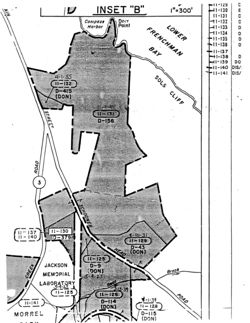
LOT NO. 8. Beginning at a stone post set in the ground in the Westerly
side of the Schooner Head Road so-called, said stone post marking the South-
east corner of land of the Mount Desert Nurseries; thence in a general
Southeasterly direction by the Schooner Head Road to the West line of land
of the United States of America conveyed by deed from The Wild Gardens of
Acadia and George B. Dorr, dated May 9, 1925 and recorded in said Registry
in Vol. 595, Page 283; thence in a general Southerly direction but every-
where following the West line of land of the United States of America to
line of land of the Jackson Memorial Laboratory; thence North nine degrees
thirty minutes West but everywhere following the Easterly line of land of
the Jackson Memorial Laboratory passing through a nail in a pine tree,
three hundred twelve and five tenths feet more or less to a nail in a spruce
tree; thence North twenty two degrees forty five minutes West one hundred
seventy seven and five tenths feet to a stone post set in the ground; thence
North seventy three degrees West, two hundred sixty feet more or less to the
Otter Creek Road, so-called; thence in a general Northerly direction by said
Otter Creek Road seven hundred feet more or less to a stone bound set in
the ground at the Southwest corner of land of the Mount Desert Nurseries;
thence North eighty six degrees nineteen minutes East, but everywhere follow-
ing the Southerly line of land of the Mount Desert Nurseries four hundred
seventy nine and eight tenths feet more or less to the stone bound the place
of beginning.
Said eight lots hereinabove described as conveyed containing ninety
six and eighty five hundredths acres, more or less.
Together with and as appurtenant to the land above described, all rights,
privileges, easements and restrictions appearing of record in the Hancock
County, Maine, Registry of Deeds affecting the same, to which records ex-
press reference is made for particular description.
Said land is also conveyed subject to any and all rights, privileges,
easements and restrictions appearing of record in said Registry of Deeds
affecting the same.
478
BOOK 681
Said land is also conveyed expressly subject to the rights of the public
in and to so much of the shore and flats as are included within the above
descriptions, and also subject to the rights of the public in and over so
much of any town way as is included within the above descriptions.
TO HAVE AND TO HOLD the aforegranted and bargained premises with, all
the privileges and appurtenances thereof, to the said United States of
America, and its assigns, to its and their use and behoof forever.
AND I DO COVENANT with the said Grantee, and its assigns, that I am
lawfully seized in fee of the premises, that they are free of all incum-
brances; that I have good right to sell and convey the same-to the said
Grantee to hold as aforesaid, and that I and my heirs shall and will WARRANT
AND DEFEND the same to the said Grantee, and its assigns forever, against the
lawful claims and demands of all persons.
IN WITNESS WHEREOF, I, the said George B. Dorr, being unmarried, have
hereunto set my hand and seal this seventh day of November, in the year
of our Lord one thousand nine hundred forty-one.
George B. Dorr (L.S.)
STATE OF MAINE
HANCOCK, SS
November 7, 1941.
Personally appeared the above named George B. Dorr and acknowledged the
above instrument to be his free act and deed.
Before me,
Notarial
Serenus B Rodick
Seal.
Notary Public.
Rec'd Jan. 3, 1942, at lh. 21m. P.M., and entered by,
George R. Hadlock,Re
THIS INDENTURE MADE THIS 11th day of September in the year
of our Lord one thousand nine hundred and forty-one, between George
B. Dorr, of Bar Harbor, Hancock County, Maine, grantor, party of the first
part, and the Secretary of the Interior, for and in behalf of the United
States of America, grantee, party of the second part.
WITNESSETH:
THAT WHEREAS by Act of Congress entitled "An Act to establish the Lafayette
National Park in the State of Maine", approved February 26, one thousand nine
hundred and nineteen, as amended by Act of Congress approved January 19th,
one thousand nine hundred and twenty-nine, the Secretary of the Interior is
authorized, in his discretion, to accept in behalf of the United States such
property in said Hancock County including lands, easements, buildings and
moneys, as may be donated for the extension or improvement of said Park, and
WHEREAS the said property hereinafter described consisting of lands and
easements is all held in private ownership by the said George. B. Dorr,
NOW THEREFORE, said party of the first part for and in consideration of the
facts above recited and of the sum of dollar to him paid by the United
States of America, the receipt of which is hereby acknowledged, does hereby
GRANT to said United States of America, two certain lots or parcels of land
situated in said Bar Harbor and bounded and described as follows, to wit:
FIRST LOT: Beginning at the intersection of the Southerly line of
Cromwells Harbor Road with Ledgelawn Avenue; Thence Easterly by Cromwells
Harbor Road to the Northwest corner of land formerly of the Bangor-Hydro
Electric Company; thence South fourteen degrees West eighty two and five
tenths feet more or less but everywhere following line of land formerly
of the Bangor Hydro Electric Company to the center of Cromwells Harbor
Brook; thence in a general Southwesterly direction by said Cromwells Harbor
Brook to its intersection with Ledgelawn Avenue Extension at the first bridge
crossing said brook South of Cromwells Harbor Road; thence in a general North-
erly direction by Ledgelawn Avenue Extension to the first mentioned bound.
Excepting from the above described lot and not hereby conveying a cer-
tain lot described as conveyed in deed from Nathan Ash to Ploomy M. Tracy,
recorded in Hancock County, Maine, Registry of Deeds Vol. 447, Page 136, to
which deed and record thereof express reference is hereby made for partic-
ular description.
)
Said lot being conveyed subject to the rights of the public in and to
so much of Ledgelawn Avenue, Ledgelawn Avenue Extension, and Cromwells
Harbor Road as adjoins the lot.
LOT NO. 2. Beginning at an iron bolt in the bridge that is built over
Cromwells Harbor Brook in the center of said brook; thence by the southern
side of Cromwells Harbor Road, seventy five feet more or less to the North-
east corner of the first lot hereinabove described as conveyed; thence South
fourteen degrees West, but everywhere following the Easterly line of the
first lot hereinabove described to the center of Cromwells Harbor Brook;
)
thence in a general Northeasterly direction by the center line of said brook
one hundred five feet more or less to the point of beginning, containing three
thousand five hundred and six square feet more or less.
Said lot being conveyed subject to the rights of the public in and to
474
BOOK 681
BY PRESENTS,
11-131
THAT the Bar Harbor Banking and Trust Company a corporation organized and
weed 156
existing under the laws of the State of Maine, and located at Bar Harbor,
Hancock County, Maine, owner of a certain mortgage given by George B. Dorr of
said Bar Harbor, to the Bar Harbor Banking and Trust Company dated March 30,
A. D. 1940, and recorded in Hancock County, Maine, Registry of Deeds, Book
672, Page 101, does hereby acknowledge that it has received full payment
and satisfaction of the same, and of the debt thereby secured, and in con-
sideration thereof it does hereby cancel and discharge said mortgage, and
release unto the said George B. Dorr, his heirs and assigns forever the
premises therein described.
IN WITNESS WHEREOF, the said Bar Harbor -Banking and Trust Company has
caused its corporate seal to be affixed, and these presents to be signed in
its name and behalf by R. E. McKown its Treasurer this third day of January
A. D. 1942.
SIGNED, SEALED AND DELIVERED
IN PRESENCE OF
BAR HARBOR BANKING AND TRUST CO.
Louise Leland
By R. E. McKown
Corporate
Treasurer Seal.
STATE OF MAINE
Hancock ss., Bar Harbor Jan. 3, 1942 Then personally appeared the above
named R. E. McKown Treasurer of Bar Harbor Banking and Trust Company and
acknowledged the foregoing instrument to be his free act and deed, and the
free act and deed of said corporation, before me
Notarial
Linwood Mayo
Seal.
Notary Public
Rec'd Jan. 3, 1942, at lh. 20m. P.M., and entered by,
George R. Hadlock, Reg'
KNOW ALL MEN BY THESE PRESENTS, THAT I, George B. Dorr, of Bar Harbor,
681/474
37,500
Hancock County, Maine, in consideration of the sum of thirty seven thousand
478
five hundred dollars, paid by the United States of America, the receipt
whereof I do hereby acknowledge, do hereby GIVE, GRANT, BARGAIN, SELL AND
CONVEY, unto the said United States of America and its assigns forever,
eight certain lots or parcels of land situated in said Bar Harbor, Hancock
County, Maine, and bounded and described as follows, to wit:
1/3/12
U.S.I.R.
LOT NO. 1. Beginning at the corner of land formerly of Harvard University
Stamps
and Anne Pierrepont Luquer on line of land of the grantor herein, marked by
$41.25
a stone post and iron bolt; thence North twenty one degrees and fifteen min-
SERIES
utes East four hundred and forty seven feet following boundary line between
1941
said grantor herein and Luquer to a stone post set in the ground on said
Canceled
line and at the Southerly and Easterly line of right of way granted by C. H.
1/3/42
Dorr to Lucy Ellis; thence on said course fifteen feet to the center line
GBD
of said right of way; thence South twenty four, degrees and thirty minutes
X
East along center line of right of way granted by Lucy Ellis to Matilda C.
Markoe, twenty-two and three tenths feet to a point sixteen and five tenths
feet distant from the last mentioned stone post, and at right angle to said
Dorr and Luquer line; thence South twenty one degrees and fifteen minutes
West ninety nine and four tenths feet along center line of said last men-
tioned right of way to a point sixteen and five tenths feet distant from
a
stone post set in the ground, and at right angle to said Dorr and Luquer
line; thence South five degrees and thirty minutes East eighty one and two
tenths feet along the center line of said right of way to a point sixteen
and five tenths feet distant from and at right angle to last described line
to .stone post set in the ground; thence South twenty degrees and forty
minutes East seventy seven and eight tenths feet along the center line of
said right of way to a point sixteen and five tenths feet distant from and
at
right angle to the last above described line to a stone post set in the
ground; thence South three degrees and fifty-five minutes West one hundred
and eight and five tenths feet along the center line of said right of way
to a point sixteen and five tenths feet distant from and at right angle
to the last described line, to a stone post set in the ground; thence South
two degrees and forty five minutes East fifty four and three tenths feet
along the center line of said right of way to intersection with boundary
line between said land formerly of Harvard University and land formerly of
Anne Pierrepont Luquer; thence South, eighty seven degrees and fifteen
minutes West sixteen and five tenths feet to a stone post set in the ground
on said boundary line for the Western boundary of said right of way; thence
on said course South eighty-seven degrees and fifteen minutes West one hun-
dred and fifty-three feet to the place of beginning, containing twenty nine
thousand and fifty nine square feet, more or less.
Said lot hereinabove described as conveyed being conveyed together with
and subject to all the conditions set forth in a certain indenture between
George B. Dorr and Anne Pierrepont Luquer, dated September 20, 1906, and re-
475
BOOK 681
corded in Hancock County, Haine, Registry of Deeds, Vol. 432, Page 456 as
modified by indenture dated November 3, 1941 to be recorded in the Hancock
County, Maine, Registry of Deeds to which indentures and record thereof
express reference is hereby made for particular description.
LOT NO. 2 Beginning at a point situated in the center of a way two rods
wide, .granted by Lucy Ellis to Matilda C. Markoe, sixteen and five tenths feet,
North eighty seven degrees and fifteen minutes East from a stone post set in
the ground on the boundary line between property formerly of Anne Pierrepont
Luquer now of said George B. Dorr and Harvard College Lot; thence South sixteen
degrees and fifty five minutes East along the center line of said way sixty
nine and eight tenths feet to a point sixteen and five tenths feet distant
and at right angle to the last above described line from a stone post set in
the ground; thence South thirty degrees and thirty five minutes East still
along the centerline of said way forty nine and one tenth feet to a point
sixteen and five tenths feet distant and at right angle to last above de-
scribed line, from a stone post set in the ground; thence South seventeen
degrees and thirty five minutes East along center line of said way one
hundred and ninety four feet to a point sixteen and five tenths feet north
eighty .six degrees and twenty minutes east from a stone post set in the
ground on the boundary line between said Harvard College Lot and land form-
erly of Theodore Chase; thence South eighty six degrees and twenty minutes
West following said line sixteen and five tenths feet to stone post set in
the ground; thence on same course South eighty six degrees and twenty min-
utes West three hundred and eighty one and five tenths feet to intersection
with easterly line of land of said George B. Dorr at a stone post set in the
ground; thence north twenty one degrees and fifteen minutes East three hun-
dred and thirty two feet to a stone post and iron bolt marking Northwest
corner of said Harvard College Lot; thence North eighty seven degrees and
fifteen minutes East following boundary line between said Harvard College
Lot and land formerly of said Anne Pierrepont Luquer and now owned by said
George B. Dorr, one hundred and fifty three feet to a stone post set in the
ground marking Westerly side line of said right of way; thence on same course
North eighty seven degrees and fifteen minutes East sixteen and five tenths
feet to place of beginning, containing one and ninety-eight hundredths acres,
more or less.
Said lot hereinabove described as conveyed being conveyed together with
and subject to all the conditions set forth in a certain indenture between
George B. Dorr and President and Fellows of Harvard College, dated November
14, 1906, and recorded in Hancock County, Maine, Registry of Deeds, Vol.
435, Page 357, to which indenture and record thereof express reference is
hereby made for particular description.
LOT NO. 3. All and the same land described as the First Lot in deed
from Matilda C. Markoe to George B. Dorr, dated October 12, 1907, and re-
corded in Vol. 454, Page 543, of the Hancock County, Maine, Registry of
Deeds, said lot being in said deed described as follows:
"Beginning at a stone post set in the ground in the Western line
of a certain private way known as the Old Right of Way Road, in the Northern
line of land of Newbold; thence South sixty-five degrees and thirty minutes
West (s. 65°-30' W.) but everywhere following said Northern line of land
of
Newbold, two hundred and eleven (211) feet, more or less to an iron bolt
set in a ledge; thence North twenty-five degrees West (N. 25° W.) passing
through two iron bolts set in ledges, seven hundred (700) feet to a stone
post set in the ground in the Southern line of a private way established
and the boundaries of which fully set forth in a certain indenture between
the parties hereto, bearing even date herewith (The Mount Desert Nurseries,
a corporation, being also a party to said indenture); thence on same course
ten (10) feet, more or less, to the center line of said private way;
thence by the following seven courses; but everywhere following the center
line of said private way, to wit: first, South sixty-seven degrees and
forty minutes East (S. 67-40 E.) one hundred and forty-three and five-
tenths (143.5)feet; thence North eighty-three degrees and three minutes
East (N. 83-3 E.) forty-six (46) feet; thence North forty-eight de-
grees and thirteen minutes East (N. 48-13 E.) fifty-six (56) feet; thence
North ten degrees and fifty-two minutes East (N. 10-52 E.) one hundred
and seventy-five and three-tenths (175.3) feet; thence North thirty-
three degrees and forty-five minutes East (N. 33-45E.) fifty-six (56) feet;
thence North thirty-seven degrees and eighteen minutes East (N. 37-18 E.)
two hundred and eighty-three (283) feet; thence North twenty-five degrees
and thirty-four minutes East (N. 25-34' E.) eighty-six (36) feet to the
center of said Old Right of Way Road in the Southern line of land formerly
of Theodore Chase; thence South four degrees and thirty minutes West
(S. 4° 30' W.) but everywhere following the center line of said old Right
of Way Road, four hundred and eighty (480) feet; thence South two degrees
and thirty minutes East (S.2-30'E.) still everywhere following the Center
line of said Old Right of Way Road, five hundred and, seventy-two (572)
feet to said Newbold line; thence South sixty-five degrees and thirty min-
utes West (S. 65-30' W.) but everywhere following said Newbold line,
one rod more or less to the place of beginning, containing six acres, more
or less. Being a parcel of land marked "Lot D." upon a certain plan made by
E. W. Hill, C. E. and entitled "Map of Property Belonging to Mrs. John Markoe
476
BOOK 681
and Geo. B. Dorr, Bar Harbor, Hancock County, Maine, 1907 which plan is to
be recorded herewith in the Hancock County, Maine, Registry of Deeds, Book
of plans."
LOT NO. 4. All and the same land described as the second Lot in deed from
Matilda C. Markoe to George B. Dorr, dated October 12, 1907, and recorded
in Vol. 454, Page 543, of the Hancock County, Maine, Registry of Deeds,
said lot being in said deed described as follows:
"Beginning at a stone post set in the ground in the Eastern line of
land of the Grantee herein, at the Southwestern corner of a lot of land
owned formerly by said Theodore Chase; thence South twenty-one degrees
and fifteen minutes West (s. 21° 15' W.) but everywhere following the Eastern
line of said land of the Grantee six hundred and forty (640) feet to a stone
post set in the ground in the North line of the private way established
as aforesaid; thence on same course ten (10) feet more or less to the center
of said private way; thence by the following eleven courses but everywhere
following the center line of said private way, to wit, first North seventy
five degrees East (N. 75 E.) ninety five (95) feet; thence North fifty-three
degrees and twenty minutes East (N. 53°-20' E.) ninety three and five-tenths
(93.5) feet; thence North sixty-one degrees and fifty minutes East (N. 61-50
E.) seventy-three (73) feet; thence South eighty-nine degrees and thirty-
four minutes East (s. 89°-34' E.) seventy (70) feet; thence South sixty-
seven degrees and forty minutes East (S. 67° 40' E.) one hundred and forty-
three and five tenths (143.5) feet; thence North eighty-three degrees and
three minutes East (N. 83°-31 E.) forty-six (46) feet; thence North for-
ty-eight degrees and thirteen minutes East (N. 48°-13' E.) fifty six feet;
thence North ten degrees and fifty-two minutes East (N. 10°-52' E.) one
hundred and seventy five and three tenths (175.3) feet; thence North thirty
three degrees and forty-five minutes East (N. 33°-45' E.) fifty-six (56) feet;
thence North thirty seven degrees and eighteen minutes East (N. 37° 18' E.)
two hundred and eighty-three feet; thence North twenty-five degrees and thirty
four minutes East (N. 25° 34' E.) heighty-six (86) feet to the South line of
said land formerly of Theodore Chase; thence South eighty-six Degrees West
(s. 86° W.) but everywhere following said South line of Chase, ten (10) feet,
more or less, to a stone post set in the ground in the Western line of said
private way; thence on same course still following the Southern line of said
land of Chase, five hundred and eighty-five (585) feet to the place of be-
ginning, containing six and five-tenths (6.5) acres, more or less."
Said Lots 3 and 4. hereinabove described as conveyed being conveyed to-
gether with and subject to all the conditions set forth in a certain deed
from Matilda C. Markoe to George B. Dorr, dated October 12, 1907 and recorded
in Hancock County, Maine, Registry of Deeds, Vol. 454, Page 543, to which
deed and record thereof express reference is hereby made for particular
description.
LOT NO. 5. Beginning at a point sixty six feet southerly measured by the
eastern side of Main Street from the Southwest corner of land formerly of
David B. Ogden; thence South sixty-two degrees thirty minutes East five
hundred seventy six feet; thence North eighty one degrees thirty minutes East
four hundred sixty five feet; thence North forty six degrees East three hun-
dred seventy six feet to the shore of Frenchman's Bay; thence Northerly by
the shore of said Frenchman's Bay four hundred fifty feet more or less to
said land formerly of David B. Ogden; thence Westerly by the south line of
land formerly of David B. Ogden to Main Street; thence Southerly by Main
Street sixty six feet to the place of beginning, containing seven and two
tenths acres more or less.
Said lot hereinabove described as conveyed being conveyed together with
and subject to all the conditions set forth in a certain indenture between
George B. Dorr and Mary E. Ogden dated October 30, 1920, and recorded in
Hancock County, Maine, Registry of Deeds, Vol. 553, Page 412, to which in-
denture and record thereof express reference is hereby made for particular
description.
LOT NO. 6 Beginning at the shore of Frenchman's Bay at the northwest
corner of land now or formerly of Luquer, on the East line of the original
Dorr lot so-called; thence in a Southwesterly direction but everywhere
following line of land of Luquer to the North line of Lot No. I hereinabove
described as conveyed; on the Southwest side of the Way Road so called;
thence in a general Northwesterly direction but everywhere following the
Southerly side of said Way Road, to its intersection with Main Street;
thence Northwesterly by Main Street to the Southwest corner of Lot No. 5
hereinabove described as conveyed; thence Easterly, Northeasterly and
Northerly but everywhere following line of Lot No. 5 hereinabove described
as conveyed to Frenchman's Bay so-called; thence by Frenchman's Bay, North-
easterly around the Point and then Southerly, to the place of beginning.
Said lot hereinabove described as conveyed being conveyed together with
and subject to all the conditions set forth in the above mentioned indenture
between Mary E. Ogden and George B. Dorr recorded in Vol. 553, Page 412,
to which indenture and the record thereof express reference is made for more
particular description.
LOT NO. 7 Beginning at the Southeast corner of Lot No. 6 hereinabove
)
described, in the East line of the original Dorr Lot so called; thence in a
general Southerly direction but everywhere following the West line of Lot
No. 1 and the West line of Lot No. 2 above described as conveyed, the lot
477
BOOK 681
of land formerly of Chase, and line of Lot No. 4 above described as conveyed,
to land of the United States of America; thence in a general Westerly direction
but everywhere following the Northerly line of land of the United States of
America to .the Schooner Head Road so called; thence in a general Northerly
direction by e Schooner Head Road, to the southwest corner of land of The
Mount Desert Nurseries, thence Northeasterly by the south line of land of
The Mount Desert Nurseries two hundred sixty-five feet, more or less, to the
Southeast corner of land of the Mount Desert Nurseries, on the West side of
a road known as "The Road under the Hill"; thence in a general Northeasterly
direction but everywhere following the West side of said road; it being also
the East line of land of the Mount Desert Nurseries, nine hundred fifty feet
more or less to a stone bound set in the ground marking the Northeast corner
of land of the Mount Desert Nurseries; thence North sixty five degrees West three
hundred seven and two tenths feet to a stone bound set in the ground; thence
South twenty seven degrees fifteen minutes West, three hundred thirty eight and
nine tenths feet to a stone bound set in the ground; thence South seventy six
degrees fifteen minutes West fifty five and seven tenths feet to a stone
bound set in the ground; thence North sixty three degrees fifty five minutes
West forty three and six tenths feet to a stone bound set in the ground;
thence North twenty five degrees ten minutes West forty six and seven tenths
feet to a stone bound set in the ground; thence North twenty two degrees
fifteen minutes East six hundred feet to a stone bound set in the ground;
thence North seventy three degrees thirty minutes East fifty seven and four
tenths feet to the stone bound set in the ground on the Southerly side of
the right of way known as "The Way Road" leading from Main Street to Sol's
Cliff, so-called; thence in a general southeasterly direction but every-
where following the Southerly side of the Way Road so-called nine hundred
feet more or less to the place of beginning.
Reserving however to the grantor herein, from the lot above described
as conveyed, the right to use and occupy for and during the term of his
natural life the following described lot, together with the buildings
thereon, being known as Storm Beach Cottage, and being bounded and "described
as follows, to wit:
Beginning at the intersection of the South side of the Way Road so-
called, with the East side of the private road known as "The Road under the
Hill"; thence in a general Southeasterly direction but everywhere following
the Southerly side of said Way Road, five hundred thirty feet more or less;
thence in a general Southerly direction but everywhere following the West-
erly side of said Way Road, seventy two feet more or less to the intersection
of the side line of said Way Road with the original East line of land of
Dorr; thence in a general Southerly direction but everywhere following the
original East line of Dorr, two hundred four feet; thence North sixty two
degrees twenty two minutes West five hundred twenty feet more or less to the
East side of said road known as "The Road under the Hill"; thence by the East
side of said road three hundred twenty seven feet more or less to the place of
beginning
Said lot No. 7 hereinabove described as conveyed being conveyed subject to
the right of The Mount Desert Nurseries, its successors and assigns, to take
water from Compass Harbor Pond so-called, on the said lot.
LOT NO. Beginning at a stone post set in the ground in the Westerly
side of the Schooner Head Road so-called, said stone post marking the South-
east corner of land of the Mount Desert Nurseries; thence in a general
Southeasterly direction by the Schooner Head Road to the West line of land
of the United States of America conveyed by deed from The Wild Gardens of
Acadia and George B. Dorr, dated May 9, 1925 and recorded in said Registry
in Vol. 595, Page 283; thence in a general Southerly direction but every-
where following the West line of land of the United States of America to
line of land of the Jackson Memorial Laboratory; thence North nine degrees
thirty minutes West but everywhere following the Easterly line of land of
the Jackson Memorial Laboratory passing through a nail in a pine tree,
three hundred twelve and five tenths feet more or less to a nail in a spruce
tree; thence North twenty two degrees forty five minutes West one hundred
seventy seven and five tenths feet to a stone post set in the ground; thence
North seventy three degrees West, two hundred sixty feet more or less to the
Otter Creek Road, so-called; thence in a general Northerly direction by said
Otter Creek Road seven hundred feet more or less to a stone bound set in
the ground at the Southwest corner of land of the Mount Desert Nurseries;
thence North eighty six degrees nineteen minutes East, but everywhere follow-
ing the Southerly line of land of the Mount Desert Nurseries four hundred
seventy nine and eight tenths feet more or less to the stone bound the place
of beginning.
Said eight lots hereinabove described as conveyed containing ninety
six and eighty five hundredths acres, more or less.
Together with and as appurtenant to the land above described, all rights,
privileges, easements and restrictions appearing of record in the Hancock
County, Maine, Registry of Deeds affecting the same, to which records ex-
press reference is made for particular description.
Said land is also conveyed subject to any and all rights, privileges,
easements and restrictions appearing of record in said Registry of Deeds
affecting the same.
478
BOOK 681
Said land is also conveyed expressly subject to the rights of the public
in and to so much of the shore and flats as are included within the above
descriptions, and also subject to the rights of the public in and over so
much of any town way as is included within the above descriptions.
TO HAVE AND TO HOLD the aforegranted and bargained premises with,all
the privileges and appurtenances thereof, to the said United States of
America, and its assigns, to its and their use and behoof forever.
AND I DO COVENANT with the said Grantee, and its assigns, that I am
lawfully seized in fee of the premises, tha t they are free of all incum-
brances; that I have good right to sell and convey the same ~to the said
Grantee to hold as aforesaid, and that I and my heirs shall and will WARRANT
AND DEFEND the same to the said Grantee, and its assigns forever, against the
lawful claims and demands of all persons.
11/7/1991
IN WITNESS WHEREOF, I, the said George B. Dorr, being unmarried, have
hereunto set my hand and seal this seventh day of November, in the year
of our Lord one thousand nine hundred forty-one.
George B. Dorr (L.S.)
STATE OF MAINE
HANCOCK, SS
November 7, 1941.
Personally appeared the above named George B. Dorr and acknowledged the
above instrument to be his free act and deed.
Before me,
Notarial
Serenus B Rodick
Seal.
Notary Public.
Rec'd Jan. 3, 1942, at lh. 21m. P.M., and entered by,
George R. Hadlock, Reg'r.
State Maine
County Hancock
Acadia National Park
Deed 156
Lot 1: Beg at cor of land formerly of Harvard University and Anne Pierrepont
Luquer on line of land of grantor herein, marked by stone post and iron bolt;
th N 21 d 15' E 447 ft fol bdry line between said grantor herein and Luquer
to stone post in ground on said line at the S & E line of r/w granted by C.
H. Dorr to Lucy Ellis; th on said course 15 ft to center line of said r/w;
th S 24 d 30' E al center line of r/w granted by Lucy Ellis to Matilda C.
Markoe, 22.3 ft to a point 16.5 ft distant from last mentioned stone post,
and at right an gle to said Dorr and Luquer line; th S 21 d 15' W 99.4 ft
al center line of said last mentioned r/w to point 16.5 ft distant from a
stone post in ground and at right angle to said Dorr and Luquer line; th S
5 d 30' E 81.2 ft al center line of said r/w to point 16.5 ft from and at
right angle to last described line to stone post in ground; th 8.20 d 40' E
77.8 ft al center line of said r/w to point 16.5 ft from and at right angle
to last described line to stone post in ground; th S 3 d 55' W 108.5 ft al
center line of said r/w to point 16.5 ft from and at right angle to last de-
scribed line, to stone post in ground; th S 2 d 45t E 54.3 ft al center line
of said r/w to intersection with bdry line between said land formerly of
Harvard Uni ersity and land formerly of Anne Pierrepont Luquer; th S 87 d 15' W
16.5 ft to stone post in ground on said bdry line for W bdry of said r/w; th
on said course S 87 d 15' W 153 ft to pob, containing 29,059 sq. ft.
Said lot hereinabove described as conveyed being conveyed together with and
subject to all conditions set forth in a certain indenture between George B.
Dorr and Anne Pierrepont Luquer, Sept. 20, 1906, recorded in Hancock Co. Reg-
istry of Deeds, Vol. 432, page 456, as modified by indenture Nov. 3, 1941 to
be recorded in Hancock County Registry of Deeds to which indentures and record
thereof express reference is hereby made for particular description.
Lot 2: Beg at a point situated in center of a way 2 rods wide, granted by Lucy
Ellis to Matilda C. Markoe, 16.5 ft, N 87 d 15' E from a stone post set in the
ground on the bdry line between property formerly of Anne Pierrepont Luquer
now of said George B. Dorr and Harvard College Lot; th S 16 d 55' E al center
line of said way 69.8 ft to a point 16.5 ft distant and at right angle to last
above described line from a stone post in ground; th S 30 d 35' E still al
centerline of said way 49.1 ft to point 16.5 ft distant and at right angle to
last above described line, from stone post in ground; th S 17 d 35' E al center
line of said way 194 ft to a pt 16.5 ft N 86 d 20' E from stone post in ground
on bdry line between said Harvard Colleg lot and land formerly of Theodore
Chase; th S 86 d 20' W fol said line 16.5 ft to stone post in ground; th on same
course S 86 d 20' W 381.5 ft to intersection with E line of land of said George
B. Dorr at stone post in ground; th N 21 d 15' E 332 ft to stone post and iron
bolt marking NW cor of said Harvard Coll ge lot; th N 87 d 15' E fol bdry line
between said Harvard College Lot and land for merly of said Anne Pierrepont Luque:
and now owned by said George B. Dorr, 153 ft to stone post in ground marking
the W side line of said r/w; th on same course N 87 d 15 E 16.5 ft to pob,
containing 1.98 acres.
Said lot hereinabofe described as conveyed being conveyed together with and
subject to all the conditions set forth in a certain indenture between George
B. Dorr and President and Fellows of Harvard College, Nov. 14, 1906, recorded
in Hancock County, Maine, Registry of Deeds, Vol 435, page 357, to which in-
denture and record thereof express reference is hereby made for particular des-
cription.
See over
Deed 156
Lot 3: All and the same land described as the 1st lot in deed from Matilda
C. Markoe to George B. Dorr, dated October 12, 1907, and recorded in Vol.
454, page 543, of the liancock Co., Maine, Registry of Deeds, said lot be-
ing in said deed described as follows: Beg. at a stone post in ground in
is line of a certain private way known as the Old Right of May Road, in the
N line of land of Newbold; th S 65 d30' If but everywhere fol said N line of
land of Newbold, 211 ft to iron bolt in ledge; th N 25 d is passing through
2 iron bolts in ledges, 700 ft to stone post in ground in S line of a private
way established and the boundaries of which fully set forth in a certain in-
denture between the parties hereto, bearing even date herewith (The Mount
Desert Nurseries, & corp., being also & party to said indenture); th on same
course 10 ft to center line of said private way; th by fol 7 courses, but
everywhere fol the center line of said private way, to wit: first, 5 67 d
40' E 143.5 ft; th E 83 d 3' E 46 ft; th N 48 d 13" E 56 ft; th N 10 d 52'
E 175.3 ft; th N 33 d 45' E 56 ft; th N 37 d 18' E 283 ft; th N 25 d 34' E
86 ft to center of said Old Right of May Road in the 5 line of land formerly
of Theodore Chase; th 5 4 d 30' I but everywhere fol center line of said Old
Right of May Road, 480 ft; th S 2 d 30' E still everywhere fol the center line
of said Old Right of May Road, 572 ft to said Newbold line; th S 65 d 30' I
but everywhere fol said Newbold line, 1 rod to pob, containing 6 acres. Be-
ing a parcel of land marked "Lot D." upon a certain plan made by E. E. Hill, C.
and entitled "Map of Property Belonging to Mrs. John Markoe and Geo. B. Dorr,
Bar Harbor, Hancock County, Maine, 1907* which plan is to be recorded here-
with in the Hancock County, Maine, Registry of Deeds, Book of plans."
Lot 41 All and the same land described as the second Lot in deed from
Matilda C. Maricoe to George B. Dorr, dated October 12, 1907, and recorded in
Vol. 454, Page 543, of the Hancock County, Maine Registry of Deeds, said lot
being in said deed described as follows:
"Beg at a stone post set in ground in the E line of land of the Grantee herein,
at the SW cor of a lot of land owned formerly by said Theodore Chase; thence
S 21 d 15' III but everywhere fol the E line of said land of the Grantee 640 ft
to stone post in ground in the N line of the private way established as afore-
said; th on same course 10 ft to center of said private way; th by the follow-
ing 11 courses but everywhere fol the center line of said private way, to wit:
first, N 75 d $ 95 ft; N 53 d 20 5, 93.5 ft; N 61 d 50' &, 73 ft; th S 89 d 36'
E 70 ft; th S 67 d 40' in 143.5 ft; N 83 d 3' E 46 ft; N 48 d 13' E 56 ft; N 10
d
52' B 175.3 ft; N 33 d 45' E 56 ft; I: 37 d 28' E 283 ft; N 25 d 34' gd 86 ft. to
S line of said land formerly of Theodore Chase; th S 86 d W but every are fol
said S line of Chase, 10 ft to stone post in ground in No line of said private
way; th on same course still fol the S line of said land of Chase, 585 ft to pob
containing 6.5 acres.
Said lots 3 and 4 hereinabove described as conveyed being conveyed together
with and subject to all the conditions set forth in a certain deed from Matilda
C. Markoe to George B. Dorr, dated October 12, 1907 and recorded in Hancock
County, Maine, Registry of Deeris, Vol. 454, page 543, to which deed and record
thereof express reference is hereby made for particular description.
Lot 5 Beg. at a point 66 ft S measured by the E side of Main St. from the
SW cor of land formerly of Lavid B. Ogden; th 5 62 d 30' E 576 ft; th N 81 d
30' E 465 ft; N 46 d E 376 ft to shore of Frenchman's Bay; th N by shore of
said Frenchman's Bay 450 ft to said land formerly of David B. Ogden; th E
See next sheet
Deed 156
by S line of land formerly of David B. Ogden to Main Street; th S by Main
Street 66 ft to pob, containing 7.2 acres.
Said lot hereinabove described as conveyed being conveyed together with and
subject to all the conditions set forth in a certain indenture Engen-George
B. Dorr andiliary E. Ogden dated October 30, 1920, and recorded in lianchek
County, Maine, Registry of Deeds, Vol. 553, Payer 122, to which indentire and
record thereof express reference is hereby made for particular description.
Lot 6: Beg at the shore of Frenchmen's Bay at the NE car of land now or forman-
ly of Luquer, on the E line a the original Dor: lot; th in a SF direction but
everywhere fol line of land of Luquer to X line of lot 1 hereinabove described
as conveyed; on the SW side of the Way Road; it in a general NW direction but
everywhere fol the S side of said day Road, to its interesection with Main
Street; th NN by Main Street to the St cor of lot 5 hereinabove described as
conveyed; th E4 NE and N but everywhere fol line of lot 5 hereinabove described
as conveyed to Frenchman's Bay; th by Frenchman's Bay, NE around the Point and
then S to pob.
Said lot hereinabove described as conveyed being conveyed together with and
subject to all the conditions set forth in the above mentioned indenture be-
tween Mary E. Ogden and George 5. Dorr recorded in Vol. 553, page 412, to which
indenture and the record thereof express reference is made for none particular
description.
Lot 7: Beg at the SE cor of lot 6 hereinabove described, in the E line of the
original Dorr lot; th in a general S direction but everywhere fol the IN line of
lot 1 and the I line of lot 2 above described as conveyed, the lot of land
formerly of Chase, and line of lot 4 above described as conveyed, to land of
the USA, th in a general be direction but everywhere fol the N line of land of
ISA, th in a general If direction by the Schooner Head Road, to SW cor of land
of The Mount Desert Nurseries, th NE by S line of land of The Mount Desert
Nurseries 265 ft to SE cor of land of Mount Desert Nurseries on the Y side of
a road known as "The Road under the Hill; th in a general NE direction but every-
where fol the W side of said road; it being also the E line of land of the Mount
Desert Nurseries, 950 ft to stone bound set in ground marking the NE cor of land
of the Mount Desert Nurseries; th N 65 d 2: 307.2 ft to stone bound set in ground;
th S 27 d 15' W, 338.9 ft to stone bound in ground; th S 76 d 15' II 55.7 ft to
stone bound in ground; th N 63 d 55' Y 43.6 It to stone bound in ground; th 25d 10' W
46.7ft; N 22 d 15 , E 600 ft to stone bound in ground; th If 73 d 30' K 57.4 ft to stone
bound in ground on the is side of the =/w brown as "The Say Road" leading from
Main Street to Sol's cliff, so-called; th in a general SE direction but every-
where fol the S side of the May Road 900 ft to pob.
Reserving however to the grantor herein, from the lot above described as con-
veyed, the right to use and occupy for and during the term of his natural life
the fol described lot, together with the buildings thereon, being known as Storm
Beach Cottage, and being bounded and described as follows, to wit:
Beg. at the intersection of the South side of the say Road with the E side of the
private road known as "The Road under the Hill"; th in a general SE direction but
everywhere fol the S side of said may Road, 530 ft; th in a general S direction
but everywhere fol the If side of said Kay Road, 72 ft to intersection of the
side line of said May Road with the original E line of land of Dorr; th in E
general S direction but everywhere fol the original E line of Dorr, 204 ft;
See over
Deed 156
Acadia National Park
th N 62 d 22' IF 520 ft to Edl side of said road known as "The Road under the
Hill"; th by E side of said road 327 ft to pcb.
Said lot 7 hereinabove described as conveyed being conveyed subject to the
right of The Mount Desert Nurseries, its successors and assigns, to take
water from Compass Harbor Pond on the said lot.
Lot 8: Beg at a stone post in ground in the 5 side of the Schooner Head Road,
said stone post marking the SE cor of land of the Mount Desert Nurseries; th
in & general SE direction by the Schooner Head Road to the W line of land of
the USA conveyed by deed from the Wild Gardens of Acadia and George B. Dorr,
dated say 9, 1925 and recorded in said Registry in Vol. 595, page 283; th in
a general S direction but everywhere fol the If line of land of the USA to line
of land of the Jackson Sepmerial Laboratory; th N 9 d 30' E but everywhere fol
the E line of land of the Jackson Memorial Laboratory passing through a nail in
a pine tree, 312.5 ft to nail in a spruce tree; th N 22 d 45' W 177.5 ft to
stone post in ground; th IN 73 d E, 260 ft to Otter Creek Road; th in a general
N direction by said Otter Creek Road 700 ft to a stone bound in ground at the
SW cor of land of the Mount Desert Nurseries; th N 86 d 19' E but everywhere
fol the S line of land of the Mount Desert Nurseries 479.8 ft to pob.
said 8 lots hereinabove described as conveyed containing 96.85 acres.
Together with and as appurtenant to the land above described, all rights,
privileges, easements and restrictions appearing of record in the Hancock
County, Maine, Registry of Deeds affecting the same, to which records express
reference is made for particular description.
said land is also conveyed subject to any and all rights, privileges, easements
and restrictions appearing of record in said Registry of Leeds affecting the same.
Said land is also conveyed expressly subject to the rights of the public in and
to so much of the shore and flats as are included within the above descriptions,
and also subject to the rights of the public in and over so much of any town way
as is included within the above descriptions.
T-129
e
INSET "B"
1"=300'
11-130
E
D
11-131
D
-11-132
D
Compass
Doir
Point
11-133
D
Harbor
11-134
D
11-135
D
11-136
D
11-137
1-138
D
1-139
DO
1-140
DIS/
11-141
DIS/
sols
132
D-415
(DON)
CLIFE
131
D-156
3
137
- 130
4-10-31
140
5 - 379
129
D - 43
(DON)
II - 125
JACKSON
0-9
Brook
DON)
MEMORIAL
LABORATORY
5-9-25
39
125
II - 126
1-1-39
D-114
128
(DON)
-115
(DON)
Hancock COUNTY RECORDS VERIFIED THROUGH Tuesday, Mar 31, 2009. LAST
Page 1 of 2
Showing 1 - 28 of 28
Search Results
(0.156 seconds)
Searched for the name 'mount desert nurseries' in ALL DOCUMENT TYPES type
documents from '1/1/1895' to '4/1/1945'
STATUS U = UNVERIFIED DOCUMENT D = DELETED A = ADDED
1
FullName
Doc
Book
Document
[row]
Status
PartyType
CrossPartyName
RecordDate
Book
Page
Instrument
Town
Type
Type
Date
MOUNT
1
A
From
DESERT
LORD, EDGAR I
6/6/1898
Survey
PLAN
1898/05/02
2
46
1753000060
1898
NURSERIES
MOUNT
DESERT
MOUNT DESERT
2
From
7/27/1908
Miscellaneous
OR
451
356
NURSERIES
NURSERIES
1908
MOUNT
3
DESERT
MOUNT DESERT
To
7/27/1908
Miscellaneous
OR
451
356
NURSERIES
11
NURSERIES
MOUNT
4
To
DESERT
STATE STREET TRUST
7/27/1908
Miscellaneous
OR
451
358
COMPANY TRUSTEE
"
NURSERIES
MOUNT
5
From
DESERT
MOUNT DESERT
7/27/1908
Miscellaneous
OR
451
360
NURSERIES
#
NURSERIES
MOUNT
MOUNT DESERT
6
To
DESERT
7/27/1908
Miscellaneous
OR
451
360
NURSERIES
11
NURSERIES
MOUNT
7
D
From
DESERT
HILL, EWCE
9/25/1922
Survey
PLAN
1922/00/00
3
80
1753000139
SULLIVAN
1922
NURSERIES
MOUNT
8
DESERT
BAR HARBOR WATER
BAR
From
9/27/1921
Deed
OR
562
316
COMPANY
HARBOR
1921
NURSERIES
MOUNT
9
DESERT
STATE STREET TRUST
To
3/10/1922
Discharge
OR
566
281
COMPANY TRUSTEE
NURSERIES
1922
MOUNT
10
DESERT
STATE STREET TRUST
To
7/31/1915
Discharge
OR
516
289
COMPANY TRUSTEE
NURSERIES
1915
MOUNT
STATE STREET TRUST
11
From
DESERT
7/31/1915
Mortgage
OR
516
290
COMPANY
1915
NURSERIES
MOUNT
BAR
12
From
DESERT
MARKOE, MATILDA C
10/30/1908
Miscellaneous
OR
454
537
HARBOR
1898
NURSERIES
MOUNT
BAR
13
To
DESERT
DORR, GEORGE B
10/30/1908
Miscellaneous
OR
454
537
HARBOR
1898
NURSERIES
MOUNT
MOUNT
14
A
From
DESERT
HILL, WG
9/25/1922
Survey
PLAN
1924/01/19
3
80
1753000139
DESERT
NURSERIES
1922
MOUNT
BAR HARBOR BANKING &
BAR
15
From
DESERT
1/7/1939
TRUST CO
Mortgage
OR
1939-01-04
666
210
1939001466
HARBOR
1959
NURSERIES
MOUNT
DESERT
BAR HARBOR BANKING &
16
To
4/1/1940
TRUST CO
Discharge
OR
1940-03-30
524
273
1940011936
NURSERIES
1940
(THE)
MOUNT
DESERT
BAR HARBOR BANKING &
17
To
1940-03-30
274
TRUST CO
4/1/1940
Discharge
OR
524
1940011937
NURSERIES
1940
(THE)
MOUNT
DESERT
BAR
18
From
DORE, GEORGE B
4/1/1940
Deed
OR
1940-03-30
672
100
1940011938
NURSERIES
HARBOR
1940
(THE)
MOUNT
http://216.220.241.165/oncoreweb/search.aspx?bd=1%2F1%2F1895&ed=4%2F1%2F194
4/1/2009
Hancock COUNTY RECORDS VERIFIED THROUGH Tuesday, Mar 31, 2009. LAST
Page 2 of 2
DESERT
BAR HARBOR BANKING &
BAR
19
From
NURSERIES
4/1/1940
Mortgage
OR
1940-03-30
672
103
1940001538
TRUST CO
HARBOR
1940
(THE)
MOUNT
DESERT
20
From
DORE, GEORGE B
4/1/1940
Deed
OR
1940-04-01
672
104
1940011939
NURSERIES
-
(940
(THE)
MOUNT
DESERT
BAR HARBOR BANKING &
BAR
21
From
10/20/1944
Miscellaneous
OR
1944-09-29
698
479
1944001655
NURSERIES
TRUST CO
HARBOR
1944
(THE)
MOUNT
BAR HARBOR BANKING
22
To
DESERT
4/1/1940
Discharge
OR
524
273
AND TRUST COMPANY
NURSERIES
1940
MOUNT
BAR HARBOR BANKING
23
To
DESERT
4/1/1940
Discharge
OR
524
274
AND TRUST COMPANY
NURSERIES
1940
MOUNT
BAR
24
To
DESERT
DORR, GEORGE B
1/22/1924
Deed
OR
585
5
HARBOR
1924
NURSERIES
MOUNT
BAR HARBOR BANKING
BAR
25
From
DESERT
1/22/1924
Mortgage
OR
585
6
AND TRUST COMPANY
HARBOR
11
NURSERIES
MOUNT
BAR HARBOR BANKING &
26
From
DESERT
5/12/1934
644
TRUST COMPANY
Assignment
OR
291
1934
NURSERIES
MOUNT
BAR
27
To
DESERT
DORR, GEORGE B
12/15/1932
Deed
OR
640
107
HARBOR
1932
NURSERIES
MOUNT
MOUNT
28
To
DESERT
SWAN, ERNEST E
4/25/1932
Mortgage
OR
638
32
DESERT
,932
NURSERIES
1
http://216.220.241.165/oncoreweb/search.aspx?bd=1%2F1%2F1895&ed=4%2F1%2F194
4/1/2009
6/28/2017
XFINITY Connect Re_ANP island property acquisition, exempting MDI Printout
Ronald Epp
6/28/2017 1:22 PM
Re: ANP island property acquisition, exempting MDI
To Emily Pagan Copy Marie Yarborough
Dear Emily,
I hope that within the last six weeks that the ANP park land title files at the Chapman law firm have
successfully come into your hands.
Have they been inventoried? Is it possible for me to examine them when I next visit MDI (that is,
July 12, 25, or 26)? My interest remains focused on those properties off MDI.
All the Best,
Ron
Ronald H. Epp, Ph.D.
532 Sassafras Dr.
Lebanon, PA 17042
717-272-0801
eppster2@.comcast.net
On May 9, 2017 at 5:02 PM Pagan, Emily wrote:
Hi Ron,
You are correct, there is no document that lists the park acquisitions similar to that of the HCTPR's. There also is no document
tracking or summarizing the process and negotiations. Park acquisitions over the years are given unique number IDs (called tract
numbers) and each tract has a file. Very few of these tracts (especially prior to 1944) have any information in them other than the
deed. So, there is very little, if any, information on how they were acquired.
Sorry there is not a more positive answer for you. I will be in the office very little that week, but if you have a specific question
stop by and I can try to help. If it is a more involved question I will most likely need to get back to you so I can put it on my
scheudle. Thanks and take care,
Emily
On Tue, May 2, 2017 at 1:02 PM, Ronald Epp wrote:
Dear Emily,
Marie Yarborough has been very helpful to my completion of the Dorr biography. In numerous
talks and interviews a recurring question has involved the federal government acquisition of
island property, exempting MDI.
I
know of no public document that chronologically lists the acquisition of island property through
the end of the Dorr administration (1944). Would you have access to such a record? Might there also
be historic information tracking the negotiation process between donor and the federal government
as there was between ANP and the Hancock County Trustees of Public Reservations?
I'll be visiting MDI the week of May 15th should you like to discuss this further.
Thank you.
Ron
Ronald H. Epp, Ph.D.
532 Sassafras Dr.
Lebanon, PA 17042
717-272-0801
eppster2@comcast.net
Emily Seger Pagan
Land Resource Specialist
Acadia National Park
P.O. Box 177
Bar Harbor, ME 04609
Viewer Controls
Toggle Page Navigator
P
Toggle Hotspots
H
Toggle Readerview
V
Toggle Search Bar
S
Toggle Viewer Info
I
Toggle Metadata
M
Zoom-In
+
Zoom-Out
-
Re-Center Document
Previous Page
←
Next Page
→
[Series III] Property Acquisition GBD & JDR JR.
| Page | Type | Title | Date | Source | Other notes |
| 1-6 | Deed | Property Deed: George B. Dorr, acknowledging act to establish Lafayette National Park | 12/31/1938 | - | - |
| 7-10 | List | George B. Dorr Property List and financial worth | - | Chapman Archive JDR Jr. Papers B143.D60 | - |
| 11-15 | List | Dorr Property List (lost?): Undated | - | Chapman Archives | - |
| 16-19 | Letter | Letter from A.H.Lynam to Charles Heydt | 10/10/1929 | - | Annotated by Ronald Epp |
| 20 | List | One of Twelve Pages of Hancock County Records List of land purchased by JDR Jr. | 1927-1936 | Hancock County | Annotated by Ronald Epp |
| 21-22 | Record | Handwritten Record detailing Dorr Property | 10/9/1879 | Hancock County Property of Deeds 167 p. 281 | - |
| 23-27 | Record | Handwritten Record detailing Dorr Property | 11/29/1879 | Hancock County Property of Deeds 169 p. 229 | - |
| 28-33 | Record | Handwritten Record detailing Dorr Property | 5/8/1898 | Hancock County Property of Deeds 324 p. 327 | - |
| 34-47 | Deed | Deed 156 | 11/7/41 - 1/3/42 | - | Annotated by Ronald Epp |
| 48 | Map | Inset B | - | - | - |
| 49-50 | Website | Hancock County Records Verified | 03/31/2009 | From https://www.hancockcountydeeds.com/search: original web address not accessible | - |
| 51 | Email from Ronald Epp to Emily Pagan: Re: ANP island property acquisition, exempting MDI | 06/28/2017 | Ronald Epp | - |

