
From collection Creating Acadia National Park: The George B. Dorr Research Archive of Ronald H. Epp


Page 1
Page 2
Page 3
Page 4
Page 5
Page 6
Page 7
Page 8
Page 9
Page 10
Page 11
Page 12
Page 13
Page 14

Page 15
Search
results in pages
[Series III] Isle au Haut
Isle all Haut
XRID
8/20/44
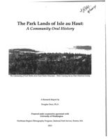
The Park Lands of Isle au Haut:
A Community Oral History
The Community of Duck Harbor from Duck Harbor Mountain - Photo Courtesy Isle au Haut Historical Society
A Research Report by
Douglas Deur, Ph.D.
Prepared under cooperative agreement with
University of Washington
Northeast Region Ethnography Program, National Park Service, Boston, MA
2013
UNITED STATES
7.36.2
DEPARTMENT OF THE INTERIOR
opey
NATIONAL PARK SERVICE
ACADIA NATIONAL PARK
Bar Harbor. Maine
From: B. Howley
PRELIMINARY REPORT ON ISLE AU HAUT
On June 3. 1943. Mr. Breese, Mr. Sullivan and myself visited Iale
au Haut to make a brief proliminary examination of the Island to form
1943.
an opinion as to the desirability of accepting the offer of the
Bowditch heirs of the gift of some 2700 acres of Land as an e xtension
to Acadia National Park.
Time did not prnit a thorough examination of the land offered.
The were able only to view it from an autonchile as we rode around it
on the encireling road. We were Agreed, however, that the land looked
good and that in all probability the Service would be justified in
accepting the offer.
As an administrative officer. my first concern was the reaction of
the Island people to the proposal. In going into this phase of the
problem I had the good fortune to talk at length with the Chairman of
the Board of Selectuon of the Town of Iale au Haut, Mr. Charles H.
Turner, and with one of the other members of the Board, Mr. Hollis B.
Revelle. It was their opinion that of the gift by the gov-
erment would met with the approval of the Island people.
Isle as Haut, Town of
The Island of Isle an Haut was originally included in the Town of
Deer Isle, Hancock County, Maine. In 1874 the Island was set off from
Deer Inle and incorporated as the Town of Iele au Haut, still in
Hancock County.
In 1912 the Town of Isle au Haut was taken from Hanoock County
and incorporated into Base COURTY The reason for this change was
that at that time there me daily steamer service to Backland, the
county seat of Inex County, while there was m public transportation
to Ellsworth, the county seat of Haneeck County. House, the business
of the town would be more easily conducted in Beekland. New, however,
with excellent mainland roads, and beat service to Beekland disease
timed, the town of Iele au Haut would be better off with it again in
Hancock County.
The resident population of the Island is 89. In - this number
increases to 200, due to influx of - visitors to the colony called
Lookout.
The valuation of the Tour for taxation purposes is, in round figures,
21,000 assessed against year-round residents, and $102,000 assessed
against gumpar residents, a total of $123,000. The tax rate for the
current year is $30,309 per $1000 of valuation.
There is one church on the Island serving the spiritual needs of the
community. one COMMON school is maintained, the enrellment in which is
seven. Children must go to Stonington on Deer Iale, or elsewhere, to
attend High School.
There are no donestie animals on the Island, a rather eurious and
unusual circumstance.
If the government accepts the gift, a total of 18 to 20 thousand
dollars of value in taxable land will be removed from the tax rolls,
representing a loss in tax revenue to the town of $600.00 at the
current rate.
The two Selectman with whom I talked summed up the matter somewhat
as follows:
The Bowditeh family has for years dominated the Island and its
doings. They purchased the greater part of the land area, and diotated
to quite an extent who should comprise the summer colony. They sold
off lots only to families of their choosing. such lots bordering the
sea. They would sell none of the rough back land to anyone. Now, how
ever, tie:heirs of the Bowditah's no longer have interest in the greater
part of the holding, and wish to be relieved of the burden of ownership
and taxation.
That boing the ease, the probability is. according to the Select-
mm, that if the government does not accept the offer of the land in
gift the owners will defaultithe taxes town will be obliged to
take it on a tax lien action. Taking by this method. they feel, would
leave the town in far worse ease them it would be if the government
accepted the land in gift. the toma would leas the taxes, and would
have great difficulty in selling the land. Government ownership of the
land and development under 19 would, they believe, attract visitors to
their Island and improve its economic status.
It would appear, therefore, that the park would receive substantial
cooperation from the Island falls if it acquired the property. That is
a very encouraging factor in considering the matter.
2
The Tract
I direct your attention to the map which a ecompanies this report.
The area in green is that proposed as a gift to the park; the
brown area is privately hold, much of it in the Bowditch heirs owner-
ship. The gift area, as you will use, is in three prits, the larger
being in the south part of the Island. A study of the Abstract of
Title discloses that of the remainder of the Island the Bowditches
own lots numbered 2-3-4-5-8-11-12 the remainder of Lot No. 32, con-
taining Sawyer Notch; and the remainder of Lot No. 36, the cast
boundary line of which crosses just eastuard of the summit of Jerusalan
Mountain. It is my suggestion that the Bowditch heirs be asked to in-
elude in the gift area the remainder of Lots 31 and 36. If they would
do so, the gift area would thereby become two parts, the separation
occurring at the northeast corner of Lot No. 7.
Lot No. 7 is owned by Chief Justice Stone of the V. S. Supreme
Court. If he were sufficiently interested to give the back end of
his land within a boundary formed by the northerly projection of the
east line of Lot No. 8, the gift area would become a solid block,
leaving but one private holding within its exterior bounds, namely,
an approximate one-fourth of Lot No. 32. I do not at the moment
know who the owner of this small parcel is.
The land on Isle au Haut, Knox County, Maine, offered in gift as
an addition to Acadia National Park, resembles in character the land
on Mt. Desort Ieland and Schoodic Penimsula now included within the
park. Its outstanding features are its bold, seaward looking oliffs
on the southern end of the Island, which are more expened and remote
than any now in park ownership.
Government ownership of the traet would present no difficult or
extraordinary connistrative problems. Until some developments are
made the area will not be the object of intensive resert by the public.
After developments are made, resort to the area will in all probability
GBD-
be through the medium of guided sea-ernise trips from the park on Mount
Desert Island. This will be in line with a plan proposed by Suparin-
tendent Dorr many years ago. and the fulfillment of which will create
an ocean-connocted island national park unique in the federal park
"cen
system.
B. L. Hadley,
Assistant Suprrintendent.
American lidland Naturalist 72, 2 cocr. 1964
1767).
MANVILLE: ISLE AU HAUT VERTEBRATES
397
The Vertebrate Fauna of Isle au Haut, Maine
Merchant Island was settled by Anthony Merchant in 1772; Kimball
Island by Seth Webb during the Revolution; and "Great Isle au Hau."
RICHARD H. MANVILLE
by Peletiah Barter in 1792. These three were incorporated in 1874
U. S. Fish and Wildlife Service, Washington, D. C.
as the township of Isle au Haut, then a part of Hancock, but si:
transferred to Knox County.
ABSTRACT: Isle au Haut, settled since 1792, is a remote island of
Early residents bore the names of Barter, Calton, Chapin, Douglas,
4,700 acres in the outer reaches of Penobscot Bay, Maine. Its historical
Grant, Kimball, Kimpton, Leland, Nutter, Rich, Sawyer and Turner,
background and environmental nature are briefly described. Listed
are 5 species of freshwater fishes, 3 amphibians, 3 reptiles, 123 birds,
many of them still conspicuous among the present inhabitants. Early
and 15 mammals recorded there. These are based on observations and
occupations were fishing, lumbering, and sheep-raising. Sheep once
specimens collected during two weeks on the island in the summer
grazed on Great Spoon, Kimball, and York islands; on Isle au Haut
of 1963. Distributional implications of insular faunas such as this are
one man once had as many as 400 sheep at once, wandering un-
discussed.
INTRODUCTION
fenced over the island and doing much damage to low vegetation.
The absence of white oak on the island prevented the development
Of the myriad islands along Maine's drowned coastline, Isle au
of a major shipbuilding industry. Subsistence farming, raising of
Haut, in the outer waters of Penobscot Bay, in Knox County, is as
potatoes, and the harvesting of fish lobsters, blueberries, and pulpwood
remote from the mainland as any except the much smaller Monhegan,
continue as important occupations.
Machias Seal, and Matinicus islands, and Mount Desert Rock.
By 1800, Isle au Haut had some 50 settlers. The population in-
Biologically, it has been explored only slightly. Since 1946, with the
creased to 300 by about 1864; since then it has steadily declined.
large gift of land from the heirs of Ernest W. Bowditch of Boston,
The Union Congregational Church at the Thorofare Settlement,
the major portion of Isle au Haut has been a part of Acadia National
dedicated in 1857, still serves as a landmark and center of community
Park, although distant by 25 miles from the headquarters area on
activities Smaller settlements have developed on the island, notably
Mount Desert Island. As yet the island has been little developed and
at Head Harbor and Robinson Point, and scattered summer homes
the pressure of summer tourists has not been felt. An inventory of the
have been built. Summer visitors had discovered the island by 1880,
fauna of Isle au Haut seems desirable, and this has been encouraged
and presently the summer colony at Point Lookout was organized.
by Paul G. Favour, Jr., Park Naturalist based at Bar Harbor. As a
The first automobiles arrived in 1914 and began to replace the horse-
result, it was my privilege to spend 12 days at Isle au Haut from
drawn buckboards and surreys. Today the summer population on
July 24 to August 4, 1963. My son accompanied me during part of
Isle au Haut may number about 300, but in 1962 there were but 12
this time, and assisted with collections and observations over a large
souls who resided the year 'round on the island.
part of the island. Local residents were most helpful and cooperative
The best historical account of the general area is Wasson's bock
in providing information. The experience was delightful and unique,
(1932), with chapters on "Isle au Haut Fishermen" and on "Tic 1
both sociologically and biologically. Incomplete as they necessarily
Bores and Lobster Sloops." A more intimate picture of Isle au H.
were, after such a brief period on Isle au Haut, my findings are here
is the brief treatment by Eustis (1952). For the most part the islande :
presented as a basis from which future studies may be made.
live an independent and isolated life, interrupted briefly by the sur-
Acknowledgments.-Without the assistance of many people this work would
mer transients. They are of course tied to the mainland by their vesse.3,
not have been accomplished. Paul G. Favour, Jr., helped with arrangements
and expedited the study in many ways. Much useful support was had from
and only occasionally is the watery highway closed - as during the
Pearl Prescott, Stanley E. Dodge, Virginia MacDonald, Lee Chapin, and
"cold snaps" of 1917 and 1943, when the mail was carried by slad
Shirley J. Marine. Others who assisted in various ways (some identified by
6 miles across the ice to Stonington. Remarkably few fires have marred
initials only in the text) were the following: Gordon Chapin (GC), Mabelle
the island landscape. In the late 1870's a fire, started by blueberry
Chapin, Barbara D. DeWitt, George Greenlaw, Mrs. Fred Hoskins (FH), Ted
pickers, burned over the summit of Champlain Mountain for about
Hoskins, Leon Liscomb, Bennie and Noyes MacDonald, Hollis Neville, and
six weeks until extinguished by snow and rain. Smaller fires occurred
Milton Weller. To all of these I am deeply grateful.
south of Duck Harbor, in 1894, and near Horseman Point in August
HISTORICAL BACKGROUND
1949. The hurricane of 1954 levelled many trees at different points
on the island.
Isle au Haut, sometimes called the "outermost island" in Penobscot
THE ENVIRONMENT
Bay, was known to the Indians, who camped here in summer. In their
shell heaps and burial sites are found the remains of deer, otter, mink,
Isle au Haut is the largest in a complex of islands along the outer
muskrat, and waterfowl. Samuel de Champlain, exploring the coast
reaches of Penobscot and Jericho bays. It is approximately 3 by
6
in 1604, gave the spot its present name, "the high island" variously
miles in extent, with several deep indentations and promontories (Fig.
spelled as Ille Haulte and l'isle haute in the 1613 and 1632 editions
1). In area it covers over 7 square miles. or about 4,700 acres, 2,800
of "Les Voyages de la Nouvelle France occidentale.
"
The nearby
of which are in Acadia National Park. A road roughly following the
periphery of the island is 14 miles long; several short roads and a
396
398
THE AMERICAN MIDLAND NATURALIST
72(2)
1964
MANVILLE: ISLE AU HAUT VERTEBRATES
399
(Fig. 3A), also variously known as Lake Champlain, Crystal Lake,
68°40'
68°35'
and Turners Lake or Pond; it is slightly more than a mile in length,
Merchant
and a tenth of a mile in greatest width.
Hardwood
TIME Acadia National Park
Pell 1.
Boundary
The island is distinctly boreal in character, with a peculiar ad-
Road
Fires
mixture of a few austral forms. The climate and the flora are es-
Nathan 1. 0
Burnt
sentially as described for Mount Desert Island (Manville, 1942).
Most of the island is forested (Fig. 3B), except for small cultivated
Point
areas near habitations. The dominant trees are conifers - white and
Lookout
red spruce, balsam fir, white cedar, red and white pine, with occasional
Richs Point
hemlock, pitch pine, and black spruce. Deciduous trees include S. gar
44°05'
Thorofare Settlement
coombs
and red maple, red oak, white, gray and yellow birch, aspen, nd
Mtn.
beech. Blueberries, bearberry, and Labrador tea comprise much or the
Kimball
Richs Core
ground cover; alder, willow, and leatherleaf are common in marsies;
1.
sphagnum bogs are frequent, and skunk cabbage (Symplocal pus
foetidus) appears abundant in most lowland areas.
York
-N-
1.
Robinson
champlain
Pt.
Black Dina
Mtn.
Bald
Mtn.
Sawyer
mtn
x
Trial
Great
Pt.t
Herbor
XMeadow
Jerusalem
Mtn.
0
Horseman
Great
Seal Trap
Pt.
spoon
Eli
1.
Bowditch
screek
Mtn.
Little
Sharks
Boom
spoon
Pt.
Beach
1.
Wentworth
Mtn.
Harbor
Sheep
X
Thief
A
Duck Harbor.
Gulch
Mtn.
Head
Harbor
Eastern
MAINE
Western
Deep
Ear
Head
Cove
Eastern Head
Western
ISLE AUHAUT
0
1 MILE
Ear
SCALE
M.W. M.
Fig. 1.-Map of Isle au Haut, Knox County, and vicinity, based on trail
map by Richard L. Bowditch and on the Deer Isle quadrangle of the U. S.
Geological Survey, 1942.
number of rather overgrown trails traverse other parts of the island,
both the interior and the coastal sectors.
The topography of the island is irregular. A central ridge of hills
runs north and south; Champlain Mountain, the highest point, reaches
543 feet in elevation, and is largely forested on the summit. These
hills terminate in rocky headlands, as at Western Head and Sharks
B
Point (Fig. 2). A number of small streams drain the interior, and
at the lower levels there are many swamps and marshes. There is
Fig. 2.-Rocky headlands on Isle au Haut. A. Western Head from near
only one body of fresh water, in the southeastern section - Long Pond
Deep Cove. B. Moore Harbor from Sharks Point.
:
APPENDIX III
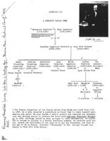
A BOWDITCH FAMILY TREE
* Nathaniel Bowditch 2m. Mary Ingersoll
(1773-1834)
(1781-1834)
Nathaniel Bowditch (1773-1838) of Salem was a self-taught
mathematician, navigator and author of The New American
Practical Natigator, first published in 1802. ou by
Charles Degued, 1835.
(1 of 8)
Anther Oboundetch
Jonathan Ingersoll Bowditch m. Lucy Orne Nichols
(1806-1889)
(1816-1883)
Henry
Charles
Charlotte
Lucy
Eliza
Alfred
two
Pickering
Pickering
Bowditch
Bowditch
Ingersoll
Bowditch infants:
Bowditeh
Bowditch
(1846-1919)
(1850-1918)
Bowditch
(1855-1918) William &
M.
(1840-1911) (1842-1921)
m.
(1852-90)
m.
Mary
m.
m.
Richard Stone
Mary Louisa Rice
Selma Knauth Cornelia Rockwell
of 8
Manfred
Mary Orne Margaret Rosamund
(1890-19 )
(1881-195 ) (1883-
(1889-1950)
m.
m.
N. P.
Augustus
Hallowell
Loring
6 children 7 children
* The famous progenitor of the family hailed from Salem and lived from 1773
to 1838. As a ship chandler's apprentice he found time to teach himself math-
ematics and Latin. He soon became a ship's captain and combined his mathemat-
ical and sailing skills to produce the still-used American Practical Navigat-
or in 1802. Although wanted by many colleges to teach mathematics, he prefer-
red to become an actuary in a Boston Insurance company. He received more hon-
ors, passed the editorship of his book on to his son Jonanthan, and died at
-
the age of 65 in Boston. Jonathan ("Grandpapa" to Mrs. Loring) brought his
family to Moss Hill from Canton.
WILLARD I. MORSE
ATTORNEY AT LAW
10 STATE STREET
BOSTON, MASS.
February 17, 1943
The Director National Park Service
Merchandise Mart
Chicago, Illinois
Attention of G. A. Moskey, Esq., Chief Counsel
Dear Sir:
I have your letter of February sixth enclosing a
copy of the opinion ( M 32034) of Theodore Spector, Esquire,
Assistant Solicitor of the Department.
Taking up the matters discussed in that opinion in
the order in which they are referred to, I beg to advise you
that the date of the close of my examination of the title was
November 4, 1942 and the certification should be dated Novem-
ber 4, 1942. I have added that date to t he certification
sheet in the copy of the abstract still in my possession and
will be glad to add it to the corresponding sheet in the
original abstract which I delivered to you, or execute a
duplicate certification bearing that date which can be added
to the original abstract.
The real estate taxes assessed as of April 1, 1942
have been paid by the Isle au Haut Land Company and no lien
for taxes exists at this date. If, however, the deed from
Isle au Haut Land Company to the United States of America is
not recorded prior to April 1, 1943 the lien for the taxes
2.
assessed as of that date will attach to the land and the Isle
au Haut Land Company will be forced to pay another whole years
taxes if I read the paragraph numbered one of the opinion
correctly.
Paragraph number two of said opinion apparently
needs no comment from me except to advise you that no improve-
ments or repairs have been made on the premises which could
3
result in mechanics liens whether of record or not and I be-
lieve I am correct in stating that under the laws of the
State
of Maine there is no such thing as a mechanics lien not a
matter of record.
I have ascertained that Clara C. Black whose husband,
if any, failed to join in her conveyance of January 12, 1912 to
Ernest W. Bowditch (abstract p. 91) was formerly the wife of
TELEPHONE LAFAYETTE 1611
WILLARD I. MORSE
ATTORNEY AT LAW
10 STATE STREET
BOSTON, MASS.
-2
February 17, 1943
Austin Black from whom she was divorced around the years 1890
or 1891; that said Austin Black died in New York City between
1901 and 1903; and that said Clara C. Black died in Rockland,
Maine on September 7, 1916 leaving no husband. This seems to
dispose of this question irrespective of the fact that a hus-
band has had no estate by the curtesy in Maine since the year
1895. See Laws 1895 Chapter 157 Sec. 2.
The interest of Lemuel Kempton or his issue in parcel
No. 9 referred to in paragraph four of the opinion appears to
me to be 80 ancient that it is wholly barred by adverse posses-
1884
sion. In the year 1884. when Ernest W. Bowditch and Albert B.
Otis were gathering in the various outstanding interests in
this parcel, they found it wholly impossible to locate either
Lemuel Kempton or his children but they did ascertain that he
had then not been heard from for twenty-six years, that at the
time of his disappearance his wife was then dead, and that at
the time of his disappearance he had two daughters then living
who had not been heard from since. From the foregoing, it ap-
5
pears that Lemuel Kempton disappeared about the year 1858 and
that the adverse possession against him and his heirs commenced
in the year 1884 when his co-tenants conveyed the property to
Bowditch and Otis. On these facts, any possible interest
which he or his children had in 1884 appears to have long
since terminated. It should also be noted that if in fact
said Lemuel Kempton died without issue, his heirs at law
were his brothers and sisters or their issue from whom said
Bowditch and Otis purchased the premises and on such a state
of facts they acquired the whole title by the recorded deeds.
As to the one-half interest in parcel No. 9 outstand-
ing of record in the heirs or devisees of Albert B. Otis, the
title must stand on the adverse possession of Ernest W. Bowditch
and his seccessors in title since August 7 1915, the date of a
deed from Isle au Haut Company to Ernest W. Bowditch, sheet 28
of the abstract, which included parcel nine. I personally dis-
cussed this matter with Mrs. Margaret S. Bowditch in 1928 and
she then told me that Albert B. Otis and her husband Ernest W.
Bowditch must have executed a deed to Isle au Haut Company of
this parcel which was, through inadvertence, never recorded and
which had been lost or destroyed because in 1907 when the Isle
au Haut Company conveyed a portion of this lot to Margaret A.
Jones, sheet 180 of the abstract, Albert B. Otis was still
interested with Mr. Bowditch in the Isle au Haut Company,
knew all about the sale to Mrs. Jones and would not have allowed
the sale to be made had he, as well as Mr. Bowditch, not supposed
the title to be in the corporation.
TELEPHONE LAFAYETTE 1611
WILLARD I. MORSE
ATTORNEY AT LAW
10 STATE STREET
BOSTON, MASS.
-3
February 17, 1943
The title to the southeasterly forty-five (45) acres
of the second tract described in Parcel No. 12, referred to in
paragraph four (b) of the opinion must stand on the adverse
possession of Ernest W. Bowditch and his successors in title
under the color of title of the deed from John C. Turner dated
June 12, I899, sheet 224 of the abstract. Sheets 228 to 234
of the abstract show the adverse chain of title to this parcel
in Henry C. Sproul in the year 1887. I made no attempt to fol-
low this adverse chain of title beyond the year 1887 except to
ascertain that Ernest W. Bowditch never acquired it and it is
possible that an examination of the records from 1887 to date
would disclose the present record ownership, The Isle au Haut
Company now believes that it has acquired a good title to this
portion of Lot 32 on the Lewis Plan by reason of its payment
of taxes and other acts of possession and it appears to me that
it may as well be included in the deed to the United States of
America for what the title is worth, and if later the successors
in record title of Henry C. Sproul make claim to it such claim
may be contested or admitted as the Department sees fit.
The Isle au Haut Company
record owner of Parcel 15
referred to in paragraph five of the opinion, ceased to trans-
act any business prior to August 21, 1915 and on that date was
excused from filing annual returns as provided for in chapter
47, Sec. 31, R.S. of Maine. It was originally incorporated on
June 28, 1883 and its original stockholders were Elihu Chauncey
18%
of New York, Ernest W. Bowditch of Boston, Charles C. Beaman, Jr.
of New York, Albert B. Otis of Boston and James R. May of Ports-
mouth, New Hampshire. Neither Mr. Richard Bowditch nor I have
any idea who the stockholders were in 1915 other than Ernest W.
Bowditch (or where the corporate records are at present. Under
these circumstances it seems impossible to elect a new board of
directors and officers and authorize the execution of a deed of
Parcel 15. Adverse possession since 1915 by the Isle au Haut
Land Company and its predecessors in title is complete and un-
questioned and it would seem to me that the government should
take this title for what it is worth.
Relative to the claim of ownership of the heirs of
Nathaniel Merchant to Lot 28, which is a portion of Parcel 7
referred to in paragraph six of the opinion, Mr. Bowditch ad-
vises me that his mother acquiesced in that claim solely for
the reason that she did not care to enter into any dispute with
residents of the island and thus cause hard feelings. Mr. Bow-
ditch does not know the basis of the claim nor do I. The record
title of Isle au Haut Land Company appears to be good and this
lot can either be left in the deed or omitted from it as you
prefer.
WILLARD I. MORSE
ATTORNEY AT LAW
10 STATE STREET
BOSTON, MASS.
-4
February 17, 1943
I will obtain and mail to you a copy of the Articles
of incorporation of Isle au Haut Land Company and evidence of
10
the payment of its franchise taxes within a few days as per
your request in paragraph seven of the opinion.
The error in the description of Parcel No. 14, re-
ferred to in paragraph nine of the opinion, has been corrected
and the proposed deed will be executed with Parcel No. 14
properly described.
The best man for Mr. George B. Dorr to interview on
GBD
Isle au Haut is Mr. Charles Turner, one of the Selectmen as
he knows more about the ownership of Mr. Bowditch, Mrs. Bowditch
and the Isle au Haut Company than anyone else on the island.
I am mailing a copy of this letter to Mr. Dorr for
his information.
Yours very truly,
WIM:K
Isle Au Haut Development creept Plan. ANP August 1990
BACKGROUND
Isle au Haut is situated 15 miles southwest of Mount Desert Island (see Figure 1).
The island is approximately six miles long and three miles wide, with its long axis
trending in an almost due north-south direction. It encompasses nearly 6,700 acres
and is surrounded by numerous small islands, particularly around its northern
shoreline. A median ridge runs most of the length of the island's long axis, with the
highest point being the summit of Mt. Champlain, 543 feet above sea level. The
NPS manages some 3,241 acres of the island comprises the Isle au Haut unit of
Acadia National Park. Most of the park land is located on the southern half of the
island.
About 55 individuals presently reside on Isle au Haut on a year round basis.
During the summer, approximately 300 summer residents spend part or all of the
season on the island. Visitation to the Isle au Haut unit of Acadia NP occurs from
May through October, with the greatest visitation occurring during July and
August.
The only access to Isle au Haut is by boat. Public transportation to the island is
provided by mail boat from Stonington -- a fishing port located six miles northwest
of Isle au Haut on the southern end of Deer Isle, some 36 miles south of Ellsworth.
The island terminus of the mail boat is the Village of Isle au Haut, the most
concentrated residential area on the island. In addition, during the summer months
the boat takes passengers to Duck Harbor which is located on the western shore of
the island within the Park. Service to Duck Harbor is available twice daily from
mid-June to mid-September, except when bad weather forces cancellation of any
trip.
Visitors to the island arrive either at the town dock in the Village of Isle au Haut or
on the south shore of Duck Harbor. The park campground is immediately adjacent
to the Duck Harbor dock facility. When the boat does not run to Duck Harbor, it
leaves visitors at the town landing, and overnight visitors must be prepared to hike
2
four and one-half miles from the town landing to Duck Harbor Campground.
During the summer, park staff attempt to monitor each mailboat arrival at the town
dock and to explain to each park visitor how to reach the park and the
campground. Also, a park ranger boards the mail boat at the town landing for the
run to Duck Harbor in order to answer questions and advise visitors about the
remote island experience on Isle au Haut.
Guided interpretive hikes are offered by the park staff member who accompanies
the noon Duck Harbor arrival. Visitors are provided with an orientation brochure
describing park trails and other places of interest. Information is also available to
the public at the ranger station, located in the village proper.
Day use is limited at the Isle au Haut portion of the Park with a fifty person limit
per day in effect since 1983. Twenty-five day use visitors are allowed during the
spring and fall. The limitation on access is designed to maintain a sense of a
remoteness to protect natural resources, and to reduce interaction of park visitors
with the local community
The remote camping experience on Isle au Haut is highly valued since this type of
experience is scarce in the northeastern region of the country. Compatible
development as determined by the Assessment of Alternatives (1977) includes five
campsites with shelter. Each shelter accommodates a maximum of 6 overnight
visitors, for a total of thirty campers, although this limit is rarely met. Overnight
camping is handled on a reservation basis from Park Headquarters on Mount
Desert Island.
PLANNING HISTORY
Land on Isle au Haut was first donated to Acadia National Park in 1943, but little
was done by the National Park Service in the way of specific planning for Isle au
Haut until a proposed master plan for Acadia was made available in 1972. The plan
recommended an exchange of Park lands for private lands in order to consolidate
Park acreage on Isle au Haut and to release non-contiguous Park land for private
use.
3
Re: Bowditch Isle au Haut Donation Date - Inbox - Verizon Yahoo! Mail
Page 1 of 1
Verizon Yahoo! Mail Verizon Central Yahoo!
Search:
Web Search
Welcome, eppster2@verizon.
Mail Home
All-New Mail
Tutorials
Help
YAHOO!
[Sign Out, Member Center ]
verizon
MAIL Classic
Mail
Contacts
Calendar
Notepad
What's New? Mobile Mail Options
Check Mail
Compose
Search Mail
Search the Web
Previous I Next I Back to Messages
Mark as Unread
Print
Folders
[Add Edit]
Delete
Inbox (6)
Reply
Forward
Spam
Move
Drafts (7)
Re: Bowditch Isle au Haut Donation Date
Thursday, September 4, 2008 2:34 PM
Sent
From: "Michael_Blaney@nps.gov"
Spam
[Empty]
To: eppster2@verizon.net
Trash
[Empty]
My Folders
[Hide]
Ronald,
DorrBio2008 (33)
Isle Au Haut Land Company donated tracts 16-102, 03, 04 in 1943,
Eliz messages (6)
Accepted
Horseshoe Pond
1/26/1944. Tract 17-101 was deeded 6/23/44 and it was accepted
12/30/44.
Member Informa
Ron Archives (31)
Your information was useful. I think I will try and acquire copies of
the
archive maps for our files.
Search Shortcuts
My Photos
Best,
My Attachments
Michael
Delete
Reply
Forward
Spam
Move
Previous Next Back to Messages
Select Message Encoding
I
Full Headers
Check Mail
Compose
Search Mail
Search the Web
Copyright © 2008 Yahoo! Inc. All rights reserved. I Copyright/IP Policy I Terms of Service I Send Feedback I Help
NOTICE: We collect personal information on this site. To learn more about how we use your information, see our Privacy Policy.
verizon
Note: See "Isle -an - Haut, llaine, and its Late."
Acadia Naboral Parh Archwes. Box HB.f5.
http://mc842.mail.yahoo.com/mc/showMessage?fid=Inbox&sort=date&order=down&start.
9/4/2008
Viewer Controls
Toggle Page Navigator
P
Toggle Hotspots
H
Toggle Readerview
V
Toggle Search Bar
S
Toggle Viewer Info
I
Toggle Metadata
M
Zoom-In
+
Zoom-Out
-
Re-Center Document
Previous Page
←
Next Page
→
[Series III] Isle au Haut
| Page | Type | Title | Date | Source | Other notes |
| 1-2 | Report | The Park Lands of Isle au Haut: A Community Oral History / Douglas Deur : Cover Page | 2013 | The Park Lands of Isle au Haut: A Community Oral History / Douglas Deur | - |
| 3-5 | Report | Preliminary Report on Isle au Haut | 1943 | From B. L. Hadley | Annotated by Ronald Epp |
| 6-7 | Journal Article | The Vertebrate Fauna of Isle au Haut, Maine / Richard Manville | 1964 | ANPA (Acadia National Park Archives): American Midland Naturalist 72, #2 | Annotated by Ronald Epp |
| 8 | Appendix | A Bowditch Family Tree | 1991 | Life Here a Century Ago / Rosamond Bowditch, Jamaica Plain Historical Society | Annotated by Ronald Epp |
| 9-12 | Letter | Letter to G.A. Moskey | 02/17/1943 | ANPA Box HJ.F.10 | Annotated by Ronald Epp |
| 13-14 | Book Excerpt | Background | 1990 | Isle au Haut Development Concept Plan | Annotated by Ronald Epp |
| 15 | Email from Michael Blaney to Ronald Epp: Re: Bowditch Isle au Haut Donation Date | 09/04/2008 | Ronald Epp | Annotated by Ronald Epp: Note: See "Isle au Haut, Maine, and its Lake." Acadia National Park Archives, HB F.5 |

