
From collection Creating Acadia National Park: The George B. Dorr Research Archive of Ronald H. Epp


Page 1
Page 2
Page 3
Page 4
Page 5
Page 6
Page 7
Page 8
Page 9
Page 10
Page 11
Page 12
Page 13
Page 14
Page 15
Page 16
Page 17
Page 18
Page 19
Page 20
Page 21
Page 22
Page 23
Page 24
Page 25
Page 26
Page 27
Page 28
Page 29
Page 30
Page 31
Page 32
Page 33
Page 34
Page 35
Page 36
Page 37
Page 38
Page 39

Page 40
Page 41
Page 42
Page 43
Page 44
Page 45
Page 46
Page 47
Page 48
Page 49
Page 50

Page 51
Page 52
Page 53
Search
results in pages
[Series III] Maps
maps
Maps of Acadia National Park
Page 1 of 6
Mapping the National Parks Home Page Acadia Grand Canyon Great Smoky Mountains Yellowstone
Maps of Acadia National Park
Early European Maps I British Maps | Nineteenth Century Nautical Charts | Mount Desert Island USGS Maps
National Park Service Maps of Acadia | Acadia Bibliography
Acadia, established in 1919, was the first national park east of the Mississippi River. It was also
the first national park on a coast, and the first to be donated to the federal government by private
individuals who gave land that they had previously owned as well as land specifically purchased,
in order to preserve it for the use of the public.
The park is located along the coast of Maine and is easily recognized from the sea by a row of
barren hills of pink granite shaped by glaciers. Its highest point, Cadillac Mountain, is more than
1500 feet above sea level. Today the park includes these mountains, wooded areas and the rugged
sea coast of parts of Mount Desert Island and the Schoodic Peninsula across Frenchman Bay to
the east, and a portion of Isle au Haut, an island to the southwest.
Although three different Native American cultures lived on or visited Mount Desert Island before
its exploration by Europeans, none of them created maps that have survived to the present.
Map of the
Recorded history and mapmaking of the area that was eventually incorporated into the park began
Discovery of the
during the Age of Discovery, when Europeans started to explore the Americas. It is believed,
East Coast of the
United States,
however, that the French used information obtained from Native Americans about the interior
1856.
lands and waterways of the North American continent on the earliest maps that they produced.
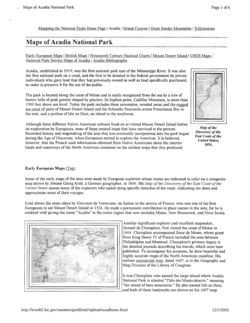
Early European Maps (Top)
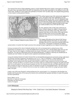
Some of the early maps of the area were made by European explorers whose routes are indicated in color on a composite
map drawn by Johann Georg Kohl, a German geographer, in 1856. His Map of the Discovery of the East Coast of the
United States names many of the explorers who sailed along specific stretches of the coast, indicating the dates and
approximate areas of their voyages.
Kohl shows the route taken by Giovanni da Verrazano, an Italian in the service of France, who was one of the first
Europeans to see Mount Desert Island in 1524. He made a permanent contribution to place names in the area, for he
is
credited with giving the name "Acadia" to the entire region that now includes Maine, New Brunswick, and Nova Scotia.
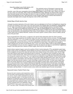
Another significant explorer and excellent mapmaker,
Samuel de Champlain, first visited the coast of Maine in
1604. Champlain accompanied Sieur de Monts, whose grant
from King Henry IV of France included the area between
Philadelphia and Montreal. Champlain's primary legacy is
the detailed journals describing his travels, which were later
published. To accompany his accounts, he drew beautiful and
highly accurate maps of the North American coastline. His
earliest manuscript map, dated 1607, is in the Geography and
Map Division of the Library of Congress.
It was Champlain who named the large island where Acadia
National Park is situated "l'Isle des Monts-deserts," meaning
"the island of bare mountains." He also named Isle au Haut,
and both of these landmarks are shown on his 1607 map.
http://lcweb2.loc.gov/ammem/gmdhtml/nphtml/acadhome.html
12/3/2002
Maps of Acadia National Park
Page 2 of 6
Map of the northeast coast of North America, 1607,
drawn by Samuel de Champlain.
The published version of Champlain's manuscript map
appeared in 1612. By the mid 1620s, and for 150 years
thereafter, most of the great cartographers showed Mount Desert Island by name on their maps, whatever the scale of
the map or their own nationality. Many of them also identified Isle au Haut, although none showed either island to
scale, primarily because most of the maps were drawn to a scale so small that it would ordinarily have precluded
showing and labeling these areas. Their placement on early European maps served to identify these locations as
landmarks that helped sailors navigate the dangerous waters off the coast of Maine.
British Maps of North America (Top)
Although the earliest exploration of the north Atlantic coast was undertaken by the French, the English also claimed the
area from the Carolinas to Nova Scotia. One of the most accurate early English maps was published by Thomas Bowen
in 1747. Maps were produced in part to substantiate the claims of various European powers to the lands of North
America. The matter was not definitively settled until 1763, when the British defeated the French to end the Seven
Years' French and Indian War. The peace treaty provided that the territory of Maine become part of the British Empire
under the administration of the Massachusetts Bay Colony. French influence in the region is still visible today, however,
in place names such as Cadillac Mountain, named for the French explorer Antoine Laumet, Sieur de Cadillac, and the
name of the park itself.
By the second half of the 18th century, in response to the need for better information about her North American
colonies, Britain began producing more detailed, larger-scale maps of the North American continent. The John Mitchell
map, first published in 1755, is an example of the highly accurate and beautifully engraved maps of that era. One of the
most famous maps in American history, it provided the cartographic information used in negotiating the Treaty of Paris
that concluded the American Revolutionary War and established the United States. Although the area included in
Acadia National Park was shown on the Mitchell map, it wasn't until Thomas Jefferys made his map of New England in
1775 and published it the next year that a mapmaker noted that the island was not drawn to scale and that it appeared as
though it were being seen from a distance of fifteen leagues, about forty-five miles offshore.
British military engineers began to survey the coastline of North America during the 1770s, and detailed coastal charts
based on these surveys were published. Samuel Holland, the Surveyor General for the Northern District, was responsible
for the compilation of many of the maps and charts drawn from original surveys of the northern coast. The first large-
scale map of Mount Desert Island was produced under his direction. Two additional charts included the waters in the
vicinity of Acadia National Park. These charts became part of a large collection of maps and charts used by the British
Navy during the American Revolution. They were engraved and compiled by Joseph Frederick Wallet Des Barres under
the collective title of The Atlantic Neptune. Large volumes of these highly detailed nautical charts, some with views of
prominent landforms and harbors, were individually compiled for sea captains sailing to America. No two volumes
appear to be the same and each contains a variety of printings or editions of the charts. The later charts contain more
detail and include information such as soundings showing the depths of coastal waters, specific locations of hazards
such as rocks and shallow areas, hachures indicating the topography of the land with its elevated areas, and cultural
geographic features such as roads, cultivated and wooded areas, and man-made structures. Later editions of the Mount
Desert Island plate clearly show settlements in the areas of Somesville, Southwest and Northeast Harbors, Hulls Cove,
Bar Harbor, and Bass Harbor. It would be another century before more detailed maps of the area were produced.
Nineteenth-Century Nautical Charts (Top)
Because the area's economy and transportation system
were sea based, requiring detailed navigational charts.
The Atlantic Neptune charts continued to be used well
into the nineteenth century. In the interim between the
production of eighteenth-century British nautical charts
and those made by the United States government during
the second half of the nineteenth century, only a few
privately produced charts were published. Captain
Seward Porter's Chart of the Coast of Maine, dated
1837, was such a chart. The sheets of this sailing chart
http://lcweb2.loc.gov/ammem/gmdhtml/nphtml/acadhome.html
12/3/2002
Maps of Acadia National Park
Page 3 of 6
show only information about the waters off of the coast;
sheets 4 and 5 pertain to the area now included in the
park.
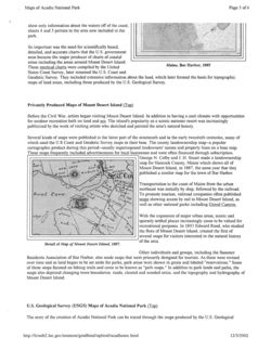
So important was the need for scientifically based,
detailed, and accurate charts that the U.S. government
soon became the major producer of charts of coastal
areas including the areas around Mount Desert Island.
These nautical charts were compiled by the United
Maine, Bar Harbor, 1885
States Coast Survey, later renamed the U.S. Coast and
Geodetic Survey. They included extensive information about the land, which later formed the basis for topographic
maps of land areas, including those produced by the U.S. Geological Survey.
Privately Produced Maps of Mount Desert Island (Top)
Before the Civil War, artists began visiting Mount Desert Island. In addition to having a cool climate with opportunities
for outdoor recreation both on land and sea. The island's popularity as a scenic summer resort was increasingly
publicized by the work of visiting artists who sketched and painted the area's natural beauty.
Several kinds of maps were published in the latter part of the nineteenth and in the early twentieth centuries, many of
which used the U.S Coast and Geodetic Survey maps as their base. The county landownership map--a popular
cartographic product during this period--usually superimposed landowners' names and property lines on a base map.
These maps frequently included advertisements for local businesses and were often financed through subscription.
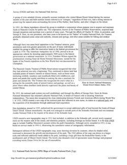
George N. Colby and J. H. Stuart made a landownership
map for Hancock County, Maine which shows all of
Mount Desert Island, in 1887, the same year that they
published a similar map for the town of Bar Harbor.
SEAL Co
Transportation to the coast of Maine from the urban
northeast was initially by ship, followed by the railroad.
Seal Cove
To promote tourism. railroad companies often published
maps showing access by rail to Mount Desert Island, as
well as other national parks including Grand Canyon.
With the expansion of major urban areas, scenic and
sparsely settled places increasingly came to be valued for
recreational purposes. In 1893 Edward Rand, who studied
the flora of Mount Desert Island, created the first of
several maps for visitors interested in the natural history
of the area.
Detail of Map of Mount Desert Island, 1887.
Other individuals and groups, including the Summer
Residents Association of Bar Harbor, also made maps that were primarily designed for tourists. As these were revised
over time and as land began to be set aside for parks, park areas were shown in green and labeled "reservations." Some
of these maps focused on hiking trails and came to be known as "path maps." In addition to park lands and paths, the
maps also depicted changing town boundaries. roads. cleared and wooded areas, and the topography and hydrography of
Mount Desert Island.
U.S. Geological Survey (USGS) Maps of Acadia National Park (Top)
The story of the creation of Acadia National Park can be traced through the maps produced by the U.S. Geological
http://lcweb2.loc.gov/ammem/gmdhtml/nphtml/acadhome.htm
12/3/2002
Maps of Acadia National Park
Page 4 of 6
Survey (USGS) and later, the National Park Service.
A group of civic-minded citizens, primarily summer residents who visited Mount Desert Island during the warmer
months of the year and built summer homes referred to as "cottages," regardless of their size, had a strong interest
in
preserving the natural areas surrounding the towns of Bar Harbor, Seal Harbor, and other villages on the island.
In 1903, the Maine legislature allowed the group to establish a corporation whose purpose was to acquire and maintain
lands in Hancock County for public use. The corporation, known as the Trustees of Public Reservations, acquired land
through donations and purchase over a period of many years. Through the efforts of Charles W. Eliot, its president, and
George B. Dorr, its vice president, who later came to be known as the "father" of Acadia National Park, the Trustees
gradually obtained scenic areas and outlooks, streams and springs, and other areas suitable for hiking and outdoor
sports.
Although there was some local opposition to the Trustees' mission, great
School
persistence and even greater generosity on the part of many individuals
enabled the group to offer the reservation lands to the federal government for
a park in 1914. The American Antiquities Act of 1906, proved to be an
appropriate vehicle for donating approximately 5000 acres to the federal
government as a national monument. In 1916, President Wilson signed the
proclamation creating Sieur de Monts National Monument. named for the
leader of the French expedition to the New World that was documented by
Champlain.
The Hancock County Trustees of Public Reservations recognized that what
they had achieved was only a beginning. They continued to obtain land that
included points of historic interest or natural beauty, such as forest tracts
sheltering wildlife, meadows and woodlands filled with wildflowers, and
pools and ponds that would contribute to making the area a sanctuary for
plant and animal life. The Trustees also recognized the area's value as a
setting for the scientific study of natural history and geology. as well as a
Sieur de Monts National Monument,
place where urban dwellers could directly experience the peace and beauty of
Mount Desert Island, Maine, 1916.
coastal Maine.
By 1919, the national park system was well established, and through the efforts of George Dorr, Sieur de Monts
National Monument was renamed Lafayette National Park, in honor of France's role in securing American
independence. The name also recognized the close relationship between French and American efforts during World War
I. In 1922, USGS created a new map of the national park that reflected its new name, its status as a national park, and
the expansion of its boundaries through additional land acquisition.
New legislation, passed in 1929, authorized the government to accept additional gifts of land beyond the limits of Mount
Desert Island. Almost immediately. the park was enlarged to include parts of the Schoodic Peninsula and was renamed
Acadia National Park at the request of the donor of the Schoodic land.
USGS created a new topographic map in 1931 that included, in addition to the Schoodic gift, several newly acquired
tracts on the western side of the island, and shoreline property, including frontage on Somes Sound. It is the first USGS
map to include Cadillac Mountain's summit within the park's boundaries. Although newly compiled in 1931, it was
based on surveys made in 1901-2, illustrating the cumulative nature of cartographic information.
Subsequent editions of the USGS topographic map, some showing elevation by contours, others by shaded relief,
continued to document the growth and development of the park. The 1942 edition of the map was drawn to a larger
scale and reflected additional lands added to the park, including a large gift from the Rockefeller family in the
southeastern part of Mount Desert Island. The family also donated a tract of spectacular ocean frontage and proposed
extending scenic Ocean Drive for the use of automobiles.
U.S. National Park Service (NPS) Maps of Acadia National Park (Top)
http://lcweb2.loc.gov/ammem/gmdhtml/nphtml/acadhome.html
12/3/2002
Maps of Acadia National Park
Page 5 of 6
The National Park Service began publishing guides to Acadia National Park and its vicinity to aid visitors in exploring
the roads, trails, and coastal areas of the park with information that was either unavailable or was difficult to see on the
USGS maps. Initially the visitor guides were published as brochures with very basic maps, their purpose being primarily
to show routes to various points of interest.
The earliest separate map of the national park appeared in
1949, with much of the earlier information from the
brochure printed on the verso. This and subsequent maps
produced by the National Park Service enabled visitors to
use the trails and carriage paths throughout the park. Most
of the recently published commercial and thematic maps
of Acadia are based on the USGS and NPS maps.
In 1952, portions of Isle au Haut and a small tract on
Little Cranberry Island were added to the park and are
reflected in the 1956 edition of the map. Other newly
acquired land shown on that edition of the map includes
Bald Porcupine Island, the site of the Baker Island
lighthouse, and large tracts of land between Eagle Lake
and Hulls Cove.
The August 1995 edition of the National Park Service
Detail of National Wetlands Inventory, [Maine], 1979.
map of Acadia National Park shows not only the park
boundaries but also the conservation easement held by the
Park Service. The purpose of easements surrounding
national parks is to protect their fragile ecosystems from damage through inappropriate use of adjacent land and water.
Growing awareness of the value of wetlands and their role in the environment led to a national survey of the
classification of wetlands by the U.S. Fish and Wildlife Service during the 1970s. The Bar Harbor sheet shows an area
far larger than the name suggests, including islands that are part of the park as well as some not within the park's
boundaries. The map was made though aerial and infrared photography. In addition to showing the classifications of
wetlands and water habitats, the inap also shows vegetation and manmade structures.
Among the historical features of Acadia National Park are the beautifully designed and constructed carriage roads which
are primarily restricted to pedestrian and equestrian use. In 1913, John D. Rockefeller Jr. began building the first
carriage road on his Seal Harbor estate. He initiated this project in response to the arrival on the island of the
automobile, which had previously been banned. and his desire to preserve roads exclusively for the use of horses and
carriages. Through his efforts, an extensive system of carriage roads was eventually built. Originally the paths were built
solely on his own property, but they became so popular not only with horsemen, but also with hikers and bicyclists, that
upon his death the system of more than 50 miles was donated to the park by the Rockefeller family. The entire project
was documented in 1989 in a National Park Service study that included a map of both the carriage and motor vehicle
roads in the park.
Acadia is one of the most frequently visited and beloved of our national parks. It is a monument to the foresight of its
founders and the generosity of the many private donors who contributed their property and labor to create it for present
and future generations.
Patricia Molen van Ee
Specialist in American Cartography
Geography and Map Division
Library of Congress
Acadia Bibliography
Mapping the National Parks Home Page Acadia Grand Canyon Great Smoky Mountains Yellowstone
http://lcweb2.loc.gov/ammem/gmdhtml/nphtml/acadhome.html
12/3/2002
AFINITY Connect
Page 1 or 1
XFINITY Connect
eppster2@comcast.ne
+ Font Size
CHAPMAN FIRM MAP COLLECTION
From : Bill Horner
Thu, Jul 28, 2011 12:12 PM
Subject : CHAPMAN FIRM MAP COLLECTION
2 attachments
To : Peter Johnson
Cc : Doug Chapman , Ron Epp , Jack
Russell , Emily Beck
Dear Peter:
I have attached a pdf version of a fairly accurate index to the extensive collection of maps at the firm. Please forward to Jack Meyers
if you think it helpful. I am also re-attaching my completed plunge into the Rockefeller file card system.
The map collection is impressive and very much in need of conservation. Not only does it reflect JDR, Jr's influence; some of the
oldest items recapitulate much of the broader history of the island. There are some beautiful and I suspect valuable hidden gems in
those pigeon holes!
Also, I found some 12 large wooden file boxes of deed and title abstracts, and many of the transactions I could recognize from my
file card inventory. While plodding through some 200 years of title transfers may sound more than tedious, the history contained
therein is amazing. I suspect that the lion's share of this work resulted from the brain and hand of Albert Harry Lynam; I tremble in
admiration. I have also discovered an interesting character in Serenus Rodick, who inherited the mantle from AHL, I believe--at least
until he died suddenly while fishing in Grand Lake Stream. That is not a bad place to go, by the way. Serenus and his brother David
were the 2 Rodicks of Deasy, Lynam, Rodick and Rodick.
Our Friends group met again yesterday and we are looking forward to a meeting with you in the latter part of August.
Best regards, Bill
ROCKEFELLER-GENERAL ABSTRACTS AND FILES AT LAW FIRM number.xlsx
38 KB
MAPS INDEX.pdf
8 MB
http://web.mail.comcast.net/zimbra/h/printmessage?id=2037&tz=America/New_York&xi..
8/29/2013
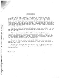
INSTRUCTIONS
Each slot has a number. The maps in each slot may not
pertain to the same area, etc. There may be one for Acadia
National Park, one for Mount Desert Island and one for Hulls
Cove. It was done this way because of the number of maps to be
taken care of and the lack of space. The same map may also be in
three different slots because the map room was in such a disaray.
There were just too many maps and trying to put them all together
was nearly impossible.
There is a box of unidentified maps under the table. If you
use one and can identify it, please let it be known SO it can be
put on the list.
There is another map list which contains all the maps
located in the metal cabinet underneath the table. There is a
drawer labeled Rockefeller maps. Most of Rockefeller's maps are
in that drawer, however, some are scattered throughout the main
map list SO you should look in both places.
There is also a large cloth roll which has numerous maps
pasted to it. This will be indexed at a later date and added
to
the main map list.
Going down through the list is one way of finding what you
are looking for. A faster way is to use the FIND button on the
word processor.
Thank you!
2A
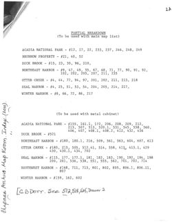
PARTIAL BREAKDOWN
(To be used with main map list)
ACADIA NATIONAL PARK - #12, 17, 22, 233, 237, 246, 248, 249
BRUNNOW PROPERTY - #21, 40, 52
DUCK BROOK - #15, 23, 30, 96, 210,
NORTHEAST HARBOR - #9, -47, 49, 55, 67, 68, 71, 77, 90, 91, 92,
102, 202, 205, 207, 211, 235
OTTER CREEK - #4, 44, 77, 94, 97, 201, 202, 211, 213, 218
SEAL HARBOR - #4, 25, 51, 53, 54, 204, 205, 214, 217,
WINTER HARBOR - #8, 66, 72, 86, 217
(To be used with metal cabinet)
ACADIA NATIONAL PARK - #155, 161.1, 172, 206, 208, 209, 212,
213, 507, 513, 520.1, 531, 545, 558, 560,
406, 407, 408.1, 408.2, 412, 432, 436
DUCK BROOK - #521
NORTHEAST HARBOR - #180, 180.1, 216, 509, 561, 563, 604, 607, 613
OTTER CREEK - #185, 215, 505, 512.41, 514, 558, 413, 413.1, 429
430, 430.1, 434, 702
SEAL HARBOR - #115, 177, 177.1, 181, 182, 183, 190, 192, 194, 198
200, 201, 536, 538, 551, 555, 562, 701, 702, 714
SOUTHWEST HARBOR - #168, 711, 713, 801, 802, 805, 806.1, 806.11,
807
WINTER HARBOR - #159, 162, 602
[G.BDorr. See 512,518,525, Drawer 2
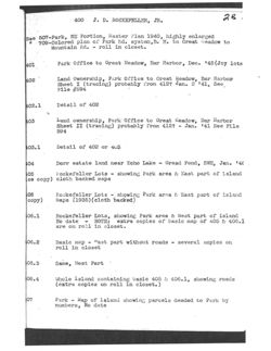
400 J. D. ROCKEFELLER, JR.
2B
See 507-Park, NE Portion, Master Plan 1940, highly enlarged
#
709-Colored plan of Park Rd. system, B. H. to Great Headow to
Mountain Rd. - roll in closet.
401
Park Office to Great Meadow, Bar Harbor, Dec. 145 (Joy lots
402
Land Ownership, Park Office to Great Meadow, Bar Harbor
Sheet I (tracing) probably from 412? Jan. 2 '41, See
File #594
402.1
Detail of 402
403
Land ownership, Park Office to Great Meadow, Bar Harbor
Sheet II (tracing) probably from 412? - Jan. 141 See File
594
403.1
Detail of 402 or 403
404
Dorr estate land near Echo Lake - Gread Pond, SWH, Jan. 14€
405
Rockefeller Lots - showing Park area E East part of island
ce copy) cloth backed maps
06
Rockefeller Lots - showing Park area is East part of island
copy)
Maps (1935) (cloth backed)
06.1
Rockefeller Lots, showing Park area & West part of island
No date - NOTE: extra copies of basic map of 405 & 406.1
are on roll in closet.
06.2
Basic map - Fast part without roads - several copies on
roll in closet
06.3
Same, West Part
06.4
Whole Island containing basic 405 & 406.1, showing roads
(extra copies on roll in closet.)
07
Park - Map of Island showing parcels deeded to Park by
numbers, No date
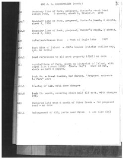
400 J. D. ROCKEFELLER (cont.) )
3.
IL
08
Boundary line of Park, proposed, Hunter's beach Head
Jordan Pond, 3 sheets, sheet 1, Blueprint 1935
08.1
Boundary line of Park, proposed, Hunter's Beach, 3 sheets,
sheet 2, 1935
08.2
Boundary line of Park, proposed, Hunter's Beach, 3 sheets,
sheet 3, 1935
409
NcFarland-Newman line
- West of Eagle Lake
1937
410
East Side of Island - JDR's bounds (outsize outline map,
old, no date.)
410.1
Deed references to all park property (JDR?) no date
411
Acquisitions of Park, shown on blueprint of Island, with
typed list (about 1928) (Govt. Map") Same as 214,
where we have 8 copies.
412
Park St. - Great Meadow, Bar Harbor, "Proposed entrance
to Park" 1934
412.1
Tracing of 412, with some changes
412.2
Park St. south, covering about half 412 area, with changes
1941
413
Numbered lots west & north of Otter Creck - for proposed
road - no date
413.1
Enlargement OI 413, parts near Creek
( seo also 514)
400 J. D.
e e 218 - Lots near Western, Robinson & DOE Mts. - west side of
also 803 - Lots at Ship Harbor, Southwest Harbor
4st
island, Pre-Park map, no date.
JDR - Dane land exchange, Wildwood Farm 1948 (3 copies)
4
15
Detail "proposed motor road" - Ocean Dr. - showing roads Pond
& property lines & lot nos., Hunter's Cove - Jordan
15.1
Same, but without proposed road, less detail
Seal Hbr. Realty Co. to JDR - Tract 1
1936- County Rd.
16
Sea Cliff Drive-Hunter's }{ead-Shows Champlain Monument
16.1
Detail of 416 - portion sold to USA by JDR
17
S. Hbr, Realty Co. to JDR - Tract 2-1936=Rowland & Upland Ra
18
S. H. Realty Co. to JDR -Tract 3-1936-Upland Rd.-west side
19
S. H. Realty Co. to JDR-Tract 4-1936-Upland Rd.-east side
(JDR 236)
420
S. H. Realty Co. to JDR-Tract 5-1936-Sea Cliff Dr.& Acadia
Pier Rds. 2 copies
421
S. H. Realty Co. to JDR-Tract 6 & 6A-1936-near S.H. Library
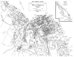
2 copies
422
S. H. Realty Co. to JDR-Tract 7- Aubrey Allen & County Rd.
423
S. H. Realty Co. to JDR-Tract 8-County Rd & Dunbar Rd.
(JDR 239)
424
S. H. Realty Co. to JDR-Tract 9-Upper Dunbar Rd.
(JDR 240)
425
S. H. Realty Co. to JDR-showing Restrictions on use of lands
426
National Park, original map 1916
400
J. D. ROCKEFFELLER JR. (cont. )
5.
427
Map of whole island, cloth back, showing Serial Deed # is
of Covt. lands - has 1939 entries
28
Great Meadow Hill Area - properties 1948-Jackson Lab.
to Ledgelawn Ave. Ext.
29
Otter Creek - Lots - North of Creek
30
11
"
ii
West of Creek (Wellington-Lothrop)
If
"
If
430.1
tracing of 430 w/data re descriptions
431
Lots between Sound & Seal Cove Pond - J.DR, Park & heservatio
No date.
432
Lot, ownership, Youngs Mtn. Area, North of Eagle Lake 1940,
on Park trail map of east part of Island.
433
Property map of Island - land of USA, JDR, etc.-JDR lot
numbers (about 1935)
434
Sketch of lot lines in area from Jordan Pond & J. P. Rd.
to Otter Creek, between Bubble Pond is County Rd. (9 lots
east of Wildwood Farm)
435
1920 map of Island on parchment paper, JDR & Park lots
colored in - no date.
436
JDR- Park official Map. used for negotiations 1935-1936 re
donations to park and location of roads.
437
Park purchase area, west side part of Island, showing original
lots. Same as Map 216.2.
6
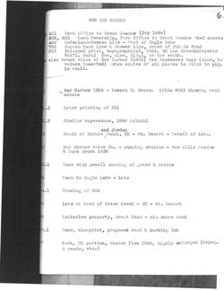
500 BAR HARBOR
401
Park Office to Great Meadow (Joy lots)
402,
403 Land Ownership, Park Office to Great Headow BH-2 sheets
409
McFarland-Newman Line - West of Eagle Lake
705
Jordan East Line is Brewer Line, south of Bubble Pond
215
Enlarged print, topographical, incl. BH (no date-LaFayette
Nat'l. Park) See, also, 215.1, to the south.
also bound Atlas of Bar Harbor (1903) Tax Assessors Maps (same, bu
values inserted) extra copies of all plates in Atlas in pkg.
in vault.
Bar Harbor 1895 - Edward B. Mears. (file 664) Showing real
estate
01.1
Later printing of 501
01.2
Similar Hap-redone, 1896 (cloth)
and Jordan
02
South of Bubble Ponds, BH - Mt. Desert - Detail of lots.
03
Bar Harbor Water Co. - pumping station - Now Mills Meadow
& Luck Brook 1939
03.1
Same with pencil showing of gates & drains
04
Tarn to Eagle Lake - Lots
04.1
Tracing of 504
05
Lots at head of Otter Creek - BH - Mt. Desert
06
Satterlee property, Great Head - old shore road
06.1
Same, blueprint, proposed road & parking lot
07
Park, NE portion, Master Plan 1940, highly enlarged (topog.
& roads, etc.)
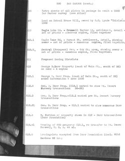
500
BAR HARBOR (cont. )
7
508
Extra sheets of all plates in package in vault - 1903
Bar Harbor survey (see Atlas)
509
Land on School House Hill, owned by S.S. Lynde "Thirlstar
1882
510
Eagle Lake Rd. - Cromwell Harbor Rd. settlement, detail
set of prints - numerous copies, filed together
510.1
Eagle Lake Rd. - Forest St. settlement, detail, showing
sewer - set of prints - numerous copies, filed together.
510.2
Central (Prospect) Ave. - Oak St. area, showing sewer -
set of prints - numerous copies, filed together.
511
Proposed Zoning Districts
512
George B.Dorr Property (east of Main St. , south of BH)
no date - 4 copies
512.1
George B. Dorr Prop. (east of Main St., south of BH)
added information - date 1938
512.2
Geo. B. Dorr Prop. (512.1 marked to show lit. Desert
Nursery transactions 38-39)
512.3
Ceo. B. Dorr Prop.-512.1 marked pre Mt. Desert Nursery
transactions
512.31
Goo. B. Dorr Prop. - 512.1 marked to show numerous Dorr
transactions
512.4
N. Portion of property shown in 512 - Dorr transactions
(Dorr Foundation)
512.41
Tracing of GBD property 512.1, re transfer to lt. Deser
Nursery, U. S. A. et al.
512.5
fracing-lots excepted from Dorr Foundation (incl. wild
Gardens BH loi)
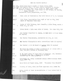
500 BAR HARBOR (cont.)
8
See 413, 413.1 lots wost & north of Otter Creek (JDR)
see 1939 Park Master Plan - 19 maps rolled together in closet.
See 452 Lots in Young's Mtn. area, north of Eagle Lake- 1940
Survey of County Rd., Sand Beach to the Bridge, in shreds,
(pkg, closet)
Thirlstane Ranch properties, see 164.
512.6
Plot plan of Reservation for Life Estate of G. B. Dorr-194
512.7
Plot Plan, Reservation from Gift of GBD to USA, 1941
(west of Schooner Head Rd.)
513
Lands of wild Gardens, Dorr Found'n. & Dorr Pers,, south O:
by
Park st., no date
514
otter Creek - Lots west side of Creek. See also 413, 413
515
Bar Harbor Plan-Fred C. Lynam, no date with cottage index
13 copies)
515.1
Bar Harbor Plan-showing correction in red, no Cate
515.2
Bar Harbor Plan-printed with corrections made (4 copies)
516
Bar Harbor - C & GS Chart of harbor 1911 (3 copies)
517
BH Water Co.-strip of land condemned in or before 1894 -
near New Mill Meadow to Woodbury Park
518
G. B. Dorr strip of land west of Ledgelaw Ave. Extensio
to Harden Farm Rd. - "Near Rock Crusher"
518.1
Another Map OI same property
519
B. H. Water Co. strip condenned around 1895-Woodbury Park-
Eagle Lake RG.
520
Lots North of Eagle Lake, 1939 "Paradise Hill Project'
520.1
Tracing of same, with new Park approach road drawn in.
521.
Lots, mouth of Duck Brook-division of land below high W
No date.
9.
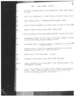
500
BAR HARBOR (cont. )
522
Detail, driveway Lyon & Lea properties, west side Eden S
No date
523
Eden St., alignment at Duck Brook, proposed change 1942
524
Kebo Valley Club - "Proposed Golf Links" 1916
525
Line, Mary E. Ugden-G. 3. Dorr, east of Main St. BH 1920
526
Land on Ocean Drive, near Bliss Farm, 1915
Pot and Kettle Club Property-blueprint framed, in vault
527
Properties North of Bagle Lake to Ocean, between Breakne
Rd. & Duck Brook, Large Scale, no date
528
Ledgelawn Ave. - Shannon Estate - Sections B E: C. & A. + F
Colored plan of Park Road system, Bar Harbor to Great
Meadow to Mountain Rd. - roll in closet
529
Hulls Cove - Roy damor Lot - plan
530
Schooner Head properties, 1879 (1900 edition)
530.1
Same, covering more area, 1906 - Map falling apart - in
envelope in closet.
531
Park Master Plan, Bar Harbor area, showing new entrance
road. 1940 (one complete set of Master Plan 1939
is bound on roll, closet) (3 copies)
10
500
BAR HARBOR (cont.)
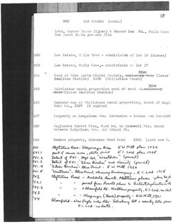
Lots, corner State Highway & Beaver Dam Rd., , Hulls Cove
See Ansel Smith provate file
532
Lee Estate, H: lls Cove - subdivision of lot 16 (Gurnee)
533
Lee Estate, Hulls Cove,- subdivision of lot 17
Eden
534
Land of Eden Agrie Itural vociety, Salisbury Cove (later
Hamilton Station) 1938 (Thirlstane Ranch)
Eden
535
Thirlstane Ranch properties west of road Saliebury
Cove (later Hamilton Station)
536
Contour map of Thirlstane Ranch properties, South of Eagl
Lako Rd., 1937 (2 copies)
537
Property on Ledgelawn Ave. Extension - Nathan Ash lot-1907
539
Engineers Street Plan, Park Rd. to Cromwell Hbr. Brook
between Ledgelawn, Ave. and School St.
540
Hawkes property, Schooner Head Road
1925 (part now U.
541
Cliftstone Road- Steepway Area
EW Hill plan 1920
541.1
part of same area, photo print El Lord plan 1905
541.2
Detail of 541 - Hoyt lot, "Westover" (pencil)
541.3
Detail 4541 - Silver Birches" and vicinity (pencil)
541.4
Silver Bisches"- Blue Print E W Hill 1920
541.5
"Westover"- Blue Print, showing landscaping - E. 1. Lord 1915
542
cleftstone Road - Archbold, Rowell, Matthews places -plan, no d
542.1
"
is
parcel from Rowell place to Batestduplication do
542.2
"
"
+ Bloomfield Rd- Matthews property E.I. Lord, no dat
543
"
"
544
- Kragman (Beale) property - EWHill, 1921
Bloomfield - New Eagle Lake Rds-Salisbany lot + nearly lots peu
E.I. Lord - no date.
11.
500
BAR HARBOR
(cont.)
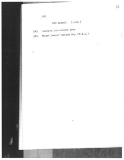
545 Jackson Laboratory Area
.546
Mount Desert Island Map (V.I.A.)
12
Drawer 2
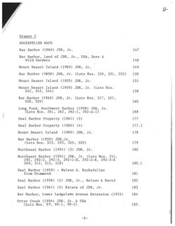
ROCKEFELLER MAPS
Bar Harbor (1960) JDR, Jr.
147
Bar Harbor, Land of JDR, Jr., , USA, Dorr &
Wild Gardens
148
Mount Desert Island (1960) JDR, Jr.
149
Bar Harbor (1958) JDR, Jr. (Lots Nos. 330, 331, 332)
150
Mount Desert Island (1955) JDR, Jr.
151
Mount Desert Island (1959) JDR, Jr. (Lots Nos.
342, 343, 344)
158
Bar Harbor (1960) JDR, Jr. (Lots Nos. 317, 327,
328, 329)
160
Long Pond, Southwest Harbor (1958) JDR, Jr.
(Lots Nos. 261, 262, 262-1, 262-A-1)
168
Seal Harbor Property (1961) (2)
177
Seal Harbor Property (1960) (4)
177.1
Mount Desert Island (1960) JDR, Jr.
178
Bar Harbor (1959) JDR, Jr.
(Lots Nos. 323, 333, 325, 326)
179
Northeast Harbor (1954) (3) JDR, Jr.
180
Northeast Harbor (1954) JDR, Jr. (Lots Nos. 214,
292, 292-2, 292-3, 292-1-X, 292-2-X, 292-3-X
308, 312, 313, 318)
180.1
Seal Harbor (1959) - Nelson A. Rockefeller
from Drummond
181
Seal Harbor (1958) (2) JDR, Jr., , Nelson & David
182
Seal Harbor (1961) (3) Estate of JDR, Jr.
183
Bar Harbor, Lower Ledgelawn Avenue Extension (1953)
184
Otter Creek (1956) JDR, Jr. & USA
(Lots Nos. 97, 98-1, 98-2)
185
-6-
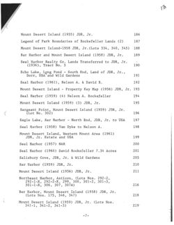
13.
Mount Desert Island (1955) JDR, Jr.
186
Legend of Park Boundaries of Rockefeller Lands (2)
187
Mount Desert Island-1958 JDR, Jr. (Lots 334, 340, 345) 188
Bar Harbor and Mount Desert Island (1958) JDR, Jr.
189
Seal Harbor Realty Co. Lands Transferred to JDR, Jr.
(1936), Tract No. 5
190
Echo Lake, Long Pond - South End, Land of JDR, Jr. ,
Dorr, USA and Wild Gardens
191
Seal Harbor (1961), Nelson A. & David R.
192
Mount Desert Island - Property Key Map (1956) JDR, Jr. 193
Seal Harbor (1959) (4) Nelson A. Rockefeller
194
Mount Desert Island (1959) (3) JDR, Jr.
195
Sargeant Point, Mount Desert Island (1959) JDR, Jr.
(Lot No. 302)
196
Eagle Lake, Bar Harbor - North End, JDR, Jr. to USA
197
Seal Harbor (1958) Van Dyke to Nelson A.
198
Mount Desert Island, Western Mount Area (1961)
JDR, Jr. Estate and USA
199
Seal Harbor (1957) NAR
200
Seal Harbor (1960) David Rockefeller 7.34 Acres
201
Salisbury Cove, JDR, Jr. & Wild Gardens
205
Bar Harbor (1959) JDR, Jr.
210
Mount Desert Island (1956) JDR, Jr.
211
Northeast Harbor, Asticou, (Lots Nos. 292-2,
292-1-X, 292-2-X, 299, 300, 301-2, 301-3,
301-1-X, 306, 307, 307A)
216
Bar Harbor, Mount Desert Island (1958) JDR, Jr.
(Lots Nos. 175, 346, 347)
218
Mount Desert Island (1959) JDR, Jr. (Lots Nos.
341-1, 341-2, 341-3)
2191
-7-
14.
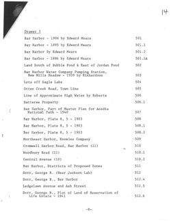
Drawer 3
Bar Harbor - 1906 by Edward Mears
501
Bar Harbor - 1895 by Edward Mears
501.1
Bar Harbor By Edward Mears
501.2
Bar Harbor - 1896 by Edward Mears
501.2A
Land South of Bubble Pond & East of Jordan Pond
502
Bar Harbor Water Company Pumping Station,
New Mills Meadow - 1939 by Richardson
503
Lots off Eagle Lake
504
Otter Creek Road, Town Line
505
Line of Approximate High Water by Roberts
506
Satteree Property
506.1
Bar Harbor, Part of Master Plan for Acadia
National Park - 1940
507
Bar Harbor, Plate 8, 5 - 1903
508
Bar Harbor, Plate 8, 5 - 1903
508.1
Bar Harbor, Plate 8, 5 - 1903
508.2
Northeast Harbor, Knowles Company
509
Cromwell Harbor Road, Bar Harbor (11)
510
tz
Woodbury Road (11)
510.1
Centrál Avenue (10)
510.2
Bar Harbor, Districts of Proposed Zones
511
Dorr, George B. (Near Jackson Lab)
512
Dorr, George B. , Bar Harbor
512.4
Ledgelawn Avenue and Ash Street
512.5
Dorr, George B. , Plot of Land of Reservation of
Life Estate - 1941
512.6
-8-
15.
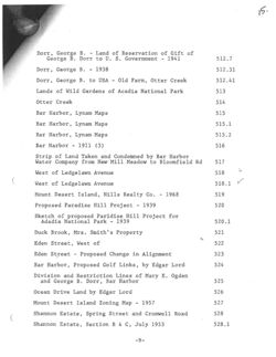
Dorr, George B. - Land of Reservation of Gift of
George B. Dorr to U. S. Government - 1941
512.7
Dorr, George B. - 1938
512.31
Dorr, George B. to USA - Old Farm, Otter Creek
512.41
Lands of Wild Gardens of Acadia National Park
513
Otter Creek
514
Bar Harbor, Lynam Maps
515
Bar Harbor, Lynam Maps
515.1
Bar Harbor, Lynam Maps
515.2
Bar Harbor - 1911 (3)
516
Strip of Land Taken and Condemned by Bar Harbor
Water Company from New Mill Meadow to Bloomfield Rd
517
West of Ledgelawn Avenue
518
West of Ledgelawn Avenue
518.1
Mount Desert Island, Hills Realty Co. - 1968
519
Proposed Paradise Hill Project - 1939
520
Sketch of proposed Paridise Hill Project for
Adadia National Park - 1939
520.1
Duck Brook, Mrs. Smith's Property
521
tiz
Eden Street, West of
522
Eden Street - Proposed Change in Alignment
523
Bar Harbor, Proposed Golf Links, by Edgar Lord
524
Division and Restriction Lines of Mary E. Ogden
and George B. Dorr, Bar Harbor
525
Ocean Drive Land by Edgar Lord
526
Mount Desert Island Zoning Map - 1957
527
Shannon Estate, Spring Street and Cromwell Road
528
Shannon Estate, Section B & C, July 1953
528.1
-9-
16.
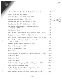
Shannon Estate, Section A (Ledgelawn Avenue)
528
Hulls Cove Lot, Roy Hamor
529
Schooner Head, July 1819, Rev. 1900
530
Acadia National Park - 1936 (3)
531
531.1 WHAT Lzz
Lee Estate, Lot 16, Hulls Cove - 1936
532
188
Lee Estate, Lot 17, Hulls Cove - 1936
533
Salisbury Cove Property, Eden Agricultural
Society - 1938 (2)
534
Thirlstance Road
535
Seal Harbor, Merle-Smith Pyle, Dorothy Prop. - 1957
536
Ledgelawn Avenue - 1907 by Edgar Lord
537
Seal Harbor, Subdivision for Hills Realty Co. - 1965
538
Ash, Spring, School, Ledgelawn, Cromwell,
Harbor Road
539
Hawkes, Morris (Mrs) Property - 1925
540
Plan of Steepways - 1920
541
Plan of Steepways - 1906
541.1
Eden Street
541.4
Hoyt, Carmelia B. Property, Plan of Westoner, - 1915
541.5
Cleftstone Road
542
Cleftstone Road
542.1
Cleftstone Road
542.2
Beale, William Property, Plan of Kragmyr, - 1921
543
Eden Street, Highbrook Road
544
Acadia National Park (Near Ledgelawn), Great
Meadow Hill Area
545
Mount Desert Island, Building Zoning Map (1939)
546
-10-
17.
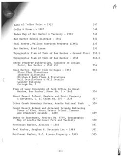
Land of Indian Point - 1952
547
Colby & Stuart - 1887
548
Index Map of Bar Harbor & Vacinity - 1903
549
Bar Harbor School District - 1951
550
Seal Harbor, Wallace Harrison Property (1961)
551
Bar Harbor, Fred Lynam
552
Topographic Plan of Town of Bar Harbor - Ground Floor
553.1
Topographic Plan of Town of Bar Harbor - 1966
553.2
Shore Property Subdivision, Vacinity of Indian
Point, Bar Harbor - 1962 (5)
554
Seal Harbor, Harbor Club Cottages - 1955
555
Floor Plan Elevations
Interior Elevations
Kitchen & Bath Plans & Elevations
Wall Details-Door & Sill Details
Laundry Building
Cottage No. 1
Plan of Land Ownership of Park Office to Great
Meadow, Bar Harbor, Sheet No. 1 - 1941
556
Mount Desert Island, Sanders and Scott Property
& Environs, U. S. Chart No. 307 - 1938
557
Otter Creek Boundary Survey, Acadia National Park
558
in
Mount Desert Island and Adjacent Islands Embracing
Towns of Eden, Mount Desert Island, Tremont
and Cranberry Islands - 1880
559
Index to Exposures, Project No. 8740, Topographic
Map of Acadia National Park and Vacinity
560
Northeast Harbor, Asticou - 1955
561
Seal Harbor, Stephen R. Petschek Lot - 1963
562
Northeast Harbor, H.C. Rivers Property - 1965
563
-11-
18.
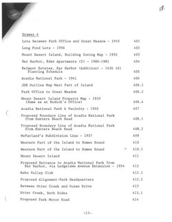
Drawer 4
Lots Between Park Office and Great Meadow - 1945
401
Long Pond Lots - 1956
402
Mount Desert Island, Building Zoning Map - 1955
403
Bar Harbor, Eden Apartments (5) - 1980-1981
404
Belmont Estates, Bar Harbor (Addition) - 1436 (6)
Planting Schedule
405
Acadia National Park - 1941
406
JDR Outline Map West Part of Island
406.1
Park Office to Great Meadow
406.2
Mount Desert Island Property Map - 1935
(Same as at Rodick's Office)
406.4
Acadia National Park & Vacinity - 1935
407
Proposed Boundary Line of Acadia National Park
from Hunters Beach Head
408.1
Proposed Boundary Line of Acadia National Park
from Hunters Beach Head
408.2
McFarland's Subdivision Line - 1937
409
Western Part of the Island to Somes Sound
410
Western Part of the Island to Somes Sound
A
410.1
Mount Desert Island
411
Proposed Entrance to Acadia National Park from
Bar Harbor, via Ledgelawn Avenue Extension - 1954
412
Kebo Valley Club
412.1
Proposed Alignment-Park Headquarters
412.2
Between Otter Creek and Ocean Drive
413
Otter Creek, Both Sides
413.1
Proposed Park Motor Road
414
-12-
19.
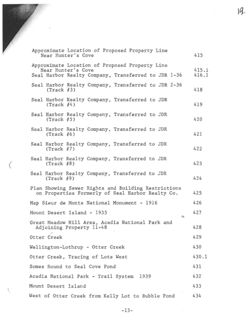
Approximate Location of Proposed Property Line
Near Hunter's Cove
415
Approximate Location of Proposed Property Line
Near Hunter's Cove
415.1
Seal Harbor Realty Company, Transferred to JDR 1-36
416.1
Seal Harbor Realty Company, Transferred to JDR 2-36
(Track #3)
418
Seal Harbor Realty Company, Transferred to JDR
(Track #4)
419
Seal Harbor Realty Company, Transferred to JDR
(Track #5)
420
Seal Harbor Realty Company, Transferred to JDR
(Track #6)
421
Seal Harbor Realty Company, Transferred to JDR
(Track #7)
422
Seal Harbor Realty Company, Transferred to JDR
(Track #8)
423
Seal Harbor Realty Company, Transferred to JDR
(Track #9)
424
Plan Showing Sewer Rights and Building Restrictions
on Properties Formerly of Seal Harbor Realty Co.
425
Map Sieur de Monts National Monument - 1916
426
Mount Desert Island - 1935
427
the
Great Meadow Hill Area, Acadia National Park and
Adjoining Property 11-48
428
Otter Creek
429
Wellington-Lothrup - Otter Creek
430
Otter Creek, Tracing of Lots West
430.1
Somes Sound to Seal Cove Pond
431
Acadia National Park - Trail System 1939
432
Mount Desert Island
433
West of Otter Creek from Kelly Lot to Bubble Pond
434
-13-
9/2015
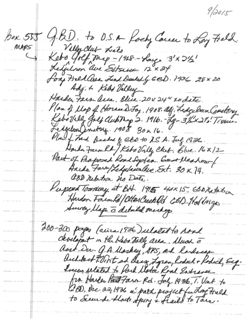
Box 555 QBD. to D.S.A Rochy Course to Love Field.
MAPS
Killy
club Links
golf, map - 1928 hay 3' x 2 1/2'
Ledfillion ave Eitsen 12x24
for Field Area Land Dealedly 6BD. 1936 28x20
Adj. to Kebs Valley
Harden Farm area Blue 20x24 to date
Plan of Map of Horased Joy. 1908. as. Ledgelown Cemetery
Kebovele golf Club thip 2. 1916. Lg 3/2x27 Tissue
1908 30x 16.
Plan f had Deaded 2 GBD to U.S.A. July 1936
Harden Villy Club. Blue 16x12
Part of Proposed Road Septem. Goat bleadow
Harder Ext. 30 x 14.
GBD netation no Date.
Pupped Townway at BH 1915 40x 15
Survey Map c detail marking
Harden CBD Holdange
200-300 pages (aliza 1936) ulatal to road
developmet in the Rebo Tally area Much c
asst Du G.A Maskey, GPS, and landscape
archetect Hint ad Deaz Lynen, Roduch & Rodich, Eg.
loseen related to Park Motor Road Entrance
from Hailer Past Farm Rd. July 1936 T. Vint to
GBD, Dcc 22,1936 in path project fee Long Field
to Secorde Most spiny & frails to Tare.
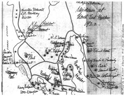
UPPER
HADLOCK
POND
Map
23
charlton Yaruall
residence at
Sance
J.A. Murray
Diston
Word East Harber
N.E.
Harbor
clamps .
w.id
goll Grounds
Leyh
b
W.
S/miller
Sisteen
W.J. Turney
*
In
Harborsic
OFFICE
Club
J. linis
,
Jeson
b
Linon
G W. Pipper
Rechard Hart
Tennis
C
Crowwell
A
c.e
Club
Gano Wann
Prest N.E.
9
Harbor v.da
P.O
Prof brancer He Perbady
be
The
TH. Carte
Swiming
Mishine
a
Samush Elist
Pool
Rockyn House
Cliftony
Hitel Kimped
House
Dr
Dropy
House
day
Henry Parkmen
Deam os milliken
w. Elest x
Um Vaughan
W. Fraser
@
Coming
PATHMAKERS
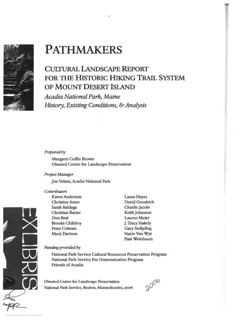
CULTURAL LANDSCAPE REPORT
FOR THE HISTORIC HIKING TRAIL SYSTEM
OF MOUNT DESERT ISLAND
Acadia National Park, Maine
History, Existing Conditions, & Analysis
Prepared by
Margaret Coffin Brown
Olmsted Center for Landscape Preservation
Project Manager
Jim Vekasi, Acadia National Park
Contributors
Karen Anderson
Laura Hayes
Christine Arato
David Goodrich
Sarah Baldyga
Charlie Jacobi
Christian Barter
Keith Johnston
Don Beal
Lauren Meier
Brooke Childrey
J. Tracy Stakely
Peter Colman
Gary Stellpflug
Mark Davison
Stacie Van Wyk
Paul Weinbaum
Funding provided by
National Park Service Cultural Resources Preservation Program
National Park Service Fee Demonstration Program
Friends of Acadia
Olmsted Center for Landscape Preservation
National Park Service, Boston, Massachusetts, 2006
2006
PRR
The
Bar Island
Sheep
Porcupine
Sunset HIII
Youngs
Baid
Great Hill
BAR
Poroupine
HARBOR
Dan Brewers
McFarlanMt.
Mt.
Youn iDistrict
Ogden Pt.
1
Strawberry
Great Pond
Kebo
II
Hill
Mt.
Aunt Here
Pond
Hardwood
Hill
The White Cap
The Thrumpcap
-
Valley
Sou
2
Sargent District
Mt.
Ricket Mt.
Green
Mt.
Schooner Head
Little
Gilmore
Berg Pk.
Browns
Pk.
The
Mt.
Mt.
otter
Bald
Half week
Mt.
Jordan
Sand
Iscac
Great Head
Valley
sorhand.Nt.
Schoothouse
The Bluffs
Hill
The Triad
Otter Creek
Browns
Ceder Swamp
Hadlock
Mt.
Upper-Pond
Southand
Bear Hill
off
OtterCliffs
Otter
Hallow
Faint Hill
Day; Mt.
LoverPond
The Black Woods
Redfield Him
Otter CreekPt.
Pond Hill
Asticou
Harbor
Hill
BAR HARBOR
Bill
Asucon
VILLAGE IMPROVEMENT ASSOCIATION
Barr Hill
PATH MAP
Schoolhouse
Ox Hill
Ledge
Seal Harbor
OF THE EASTERN PART OF
theas Harbon
Hunters
Beach Head
MOUNT DESERT ISLAND,
MAINE.
Savages Pt.
East Pt.
Capariable 1896 8 Waldrens Bater Marbert Javanc
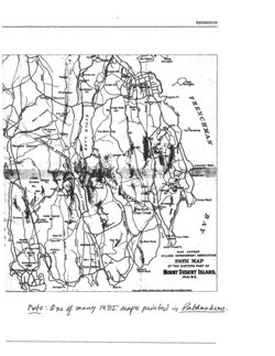
note One of many MDI maps printed in Pathmakers.
Y-FIVE
years
Digital Sanborn Maps
CHADWYCK-HEALEY
1867-1970
1973-1998
AN ESSENTIAL RECORD OF U.S. GROWTH AND DEVELOPMENT
/
D
3
7
9
4
FERRY
5
MOUND (GRAVOIS
>2
WAVE
(WARE)
FRANCISCO
1883
0
1890
1913
1930
HOME OF THE HUMANITIES ON THE WEB
http://www.chadwyck.com
Table of Contents
Fire Insurance Maps
13/03
Their History and Applications
Preface
By Diane L. Oswald
Part One
The History
Chapter 1.
Old World Heritage
7
Copyright © 1997 by Diane L. Oswald
All rights reserved. No part of this book may be reproduced or transmitted in
Chapter 2.
An American Industry is Born
13
any form or by any means, electronic or mechanical, including photocopying,
Chapter 3.
The Cartographers
19
recording or by any information storage and retrieval system without prior
written permission from the author.
Chapter 4.
The Making of a Map
35
Fire Insurance Maps, Their History and Applications is not sponsored or
Part Two
endorsed in any manner by the companies or organizations mentioned in this
The Experience
book. The development, preparation and publication of this work has been
Chapter 5.
Trotter's Tales
47
undertaken with great care. However, the author, publisher and editors of
Lacewing Press are not responsible for any errors contained herein or for
Chapter 6.
Back Stage Pass
61
consequences that may ensue from use of materials or information contained in
this work.
Part Three
The Applications
Editors: Alma Maxwell and Linda Barclay
Chapter 7.
Ebb and Flow
75
Printed and bound by Newman Printing, Bryan, Texas
Chapter 8.
Maps for the Environment
83
To order additional copies of this book contact:
Lacewing Press
Chapter 9.
Maps for Architects and Others
89
15889 Woodlake Drive
College Station, Texas 77845
Part Four
In Conclusion
Library of Congress Cataloging in Publication Data
Sources
96
Oswald, Diane L.
Appendix A
Milestones in Mapping
97
Fire Insurance Maps, Their History and Applications
Diane Oswald. - First Edition
Appendix B
Selected Vendors
99
Bibliography: p.
Includes Index
Appendix C
Illustration Index
100
1. Cartography
2. Business History
3. United States History
Index
101
ISBN 0-9659698-0-0
Library of Congress Catalog Card Number: 97-94262
GEOSTAT: History of Sanborn Fire Insurance Maps
Page 1 of 3
g
CATALOGS.
INTERACTIVE
REFERENCE
CLASS
USER
STAFF &
COLLECTIONS
DATA
RESOURCES
ESOURCES
PROJECTS
SERVICES
(OSTAT: GEOSPATIAL & STATISTICAL DATA CENTER
UNIVERSITY OF VIRGIN ALIBRARY
Home I 1920 Maps I Microfilm I Symbols I History I Bibliography
Sanborn Fire Insurance Maps
By Chris Nehls, Geostat Center and Department of History, University of Virginia
A Brief History:
Although the craft of creating maps for fire insurance purposes has existed for two
centuries, the American insurance industry spurred the growth of insurance map
companies on an unprecedented scale in the last half of the nineteenth century. D. A.
Sanborn created the most successful of these companies in 1867, founding the Sanborn
National Insurance Diagram Bureau in New York City, after successfully surveying Boston
for fire insurance purposes. Despite Sanborn's death in 1883, the company expanded and
purchased other mapping companies as it grew throughout the rest of the nineteenth
century, emerging as simply the Sanborn Map Company in 1902.
Sanborn systematized and added aesthetic appeal to an industry already a century old in
the late 1800s. The creation of maps for insurance purposes originated in fire-prone
London in the late eighteenth century, as insurers attempted to gain accurate information
about insured buildings. This practice came to the United States shortly after
independence, and a fledgling industry of producing maps for insurance purposes
developed in cities across the country. By the middle of the 1800s, most cities in the East
and Midwest supported mapping companies.
The company employed surveyors in each state and systematized the map-producing
process, introducing a system of standards for accuracy and design that the company
published in 1905. While the New York suburb of Pelham served as the company's
headquarters, it maintained regional offices in San Francisco and Chicago. Sanborn
employed such a large number of surveyors so that its clients could "incur [sic] large
financial risks without making personal examinations of the properties," as its employees'
manual stated in 1905. Its most famous surveyor was Daniel Carter Beard, who joined the
Sanborn Company in 1872 and later founded the Boy Scouts of America.
Most Sanborn maps were drawn at a scale of 50 feet to an inch on 21-by-25 sheets of
paper until after World War II. They detailed the location and material composition of all
buildings within a city or town, noted the strength of fire departments, location of water
and gas mains, and labeled most public buildings by name, including churches and
companies. Buildings were color-coded according to their composition. The work of
coloring maps often fell to individual artists, who painted on lithographs (often themselves
hand-drawn) as printing often proved uneconomical for small orders. Maps were sold
primarily to national or regional underwriting associations. Standardization helped make
Sanborn a virtual monopoly by 1920, and by the late 1930s the company had surveyed
13,000 towns. Fire insurance maps, therefore, are commonly referred to simply as
Sanborn maps. They commonly cost $12 to $200 in the 1930s.
The Sanborn Company served its clients vigorously, often resurveying immediately after
disasters to note buildings that had survived and those that had been lost. When the
Chicago stockyards burned in a fire that broke out on a Saturday in 1934, the Sanborn
prepared an updated map of the damaged area the following Monday. More gradual
changes, noted by yearly company surveys, were made by pasting small stickers or
http://fisher.lib.virginia.edu/sanborn/about.html
3/21/2003
GEOSTAT: History of Sanborn Fire Insurance Maps
Page 2 of 3
patches on existing maps.
The post-World War II era held diminishing needs for new fire insurance maps, as
insurance companies either found other means of recording data or created their own
engineering divisions. The Sanborn Company nevertheless continues to revise existing
maps for 150 cities.
The Sanborn Company is currently a division of Environmental Data Resources, Inc. (EDR)
of Southport, CT.
Map Uses for Scholars:
Today, Sanborn Maps provide invaluable detail to historians, genealogists, urban planners,
architectural historians, environmentalists, economists, and many other specialists and
scholars. Because of the maps' labeling of the type, use, building material used in
construction, flammable material on site, and even name of specific buildings in towns and
cities they have become increasingly popular primary sources.
The town of Staunton, Virginia employed Sanborn maps from the late 1800s to assist its
historic preservation efforts. "Sanborn maps gave us very detailed information about when
buildings were constructed for many sections of town and alterations beginning in the
1880s," William Frazier, director of Historic Staunton told Historic Preservation in 1993.
"When we began our façade-improvement plan, we again consulted the information from
the Sanborn maps to determine an accurate appearance for a building at a specific date."
Collections:
The Library of Congress holds the most extensive collection of Sanborn Maps, with over
700,000 maps in its collection, which were deposited in accordance with copyright law.
This collection is not complete, however. EDR and the Library of Congress are currently
pursuing a project that will digitize these maps for distribution over the Internet.
Alderman Library contains a sizeable collection of facsimile Sanborn Maps from cities and
towns within Virginia on microfilm. Most cities and towns were first surveyed in the 1880s.
The Government Information Department of Alderman Library houses 29 reels of Sanborn
Maps on microfilm. This collection contains microfilm produced by Chadwick-Healey, which
reproduced Sanborn maps from the Library of Congress collection, and from University
Publications, which reproduced more recent sheets from other archives, primarily those of
the Sanborn Company.
Special Collections at Alderman Library holds the actual map sheets for Charlottesville
from 1907 and 1920.
Sources:
Fortune. "Map Monopoly." Feb. 1937. 41-42.
Keister, Kim. "Charts of Change." Historic Preservation, vol. 45 no. 3. May/June, 1993.
Ristow, Walter W. Fire Insurance Maps in the Library of Congress. Washington, D. C:
Library of Congress, 1981.
Sanborn Map Company. Description and Utilization of the Sanborn Map. New York. 1953.
http://fisher.lib.virginia.edu/sanborn/about.html
3/21/2003
12/17/2016
Mapmaker Jane Crosen - About the artist
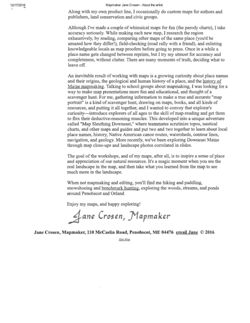
Jane Crosen, Mapmaker
Meet the Mapmaker
I discovered the world of maps while working at
HOME
DeLorme Publishing in Yarmouth, Maine, in
1979-81. During my time there we published
several Maine map & guides (Baxter,
Moosehead, Allagash), fishing and field guides,
and an all-new edition of the Maine Atlas &
Gazetteer. To do my job as in-house editor and
girl Friday, I had to gather information about
interesting places and pinpoint their locations on
maps and atlas pages. For someone with a flair
for editing and an explorer's curiosity about my
home state, it was a perfect job. I learned a lot
about researching and compiling, exploring, publishing, editing, and-by osmosis
THE ARTIST
-mapmaking.
ORDERING
DeLorme was moving into digital mapping, and with my projects finished I saw my
CONTACT
way pointing Downeast, beckoned by old friends and family roots-plus all those
alluring places I had read about compiling the Gazetteer! I moved to the Blue Hill
Peninsula and a part-time job at WoodenBoat magazine. To round out my income I
did some freelance editing for Canoe magazine, which also needed an artist who
could draw maps of canoe routes. I'd always been good at art and hand lettering,
had learned a bit about maps and graphic design, and in doing map illustrations for
both magazines I figured out how to produce simple camera-ready map layouts.
Then I got an idea: Why not make a map of the Blue Hill Peninsula, which had lots
of special places-and countless ways to get turned around? My original intent was
a poster-size map, but a friend at WoodenBoat suggested, "While you're at it, print
the map as a postcard too, large enough for giving directions." The artwork took me
months of after-hours mapmaking. Though I based the map's lines on topos and
Hockamenk
Hand
nautical charts, I wanted it to be as accurate and detailed as only a "local" could
make it, SO I drove around field-checking scenic views and boat launches, asking
local input. Then, finally, the thrill of getting the map printed and into stores! Now I
faced a new challenge, marketing but with courage and perseverance, came
success. People loved the map-and would I make maps of other Maine regions?
Suddenly I was a mapmaker and publisher, as well as an editor.
Since 1983 and that first map, I've worked my way around Maine's coastal and lake
regions, making "map portraits" of special places-which, for me, by definition
involve lots of water. My stippling and "watercolor" shading styles have evolved to
highlight the beautiful intricacy of Maine's coast and lakeshores, islands and
peninsulas.
I
design everything-borders, symbols, graphic decorations-myself, by hand. The
artwork for my two-color posters is large, labor-intensive, and fragile. Glide-Rule,
X-Acto knife, light box, and proportional scale are my tools of the trade. Fine brush
and black ink for coastlines, crowquill for ledges, forked brush for double-line
roads, calligraphy pen for place names that are reduced, waxed, and painstakingly
12/17/2016
Mapmaker Jane Crosen - About the artist
Along with my own product line, I occasionally do custom maps for authors and
publishers, land conservation and civic groups.
Although I've made a couple of whimsical maps for fun (the parody charts), I take
accuracy seriously. While making each new map, I research the region
exhaustively, by reading, comparing other maps of the same place (you'd be
amazed how they differ!), field-checking (road rally with a friend), and enlisting
knowledgeable locals as map proofers before going to press. Once in a while a
place name gets changed between reprints, but I try my utmost for accuracy and
completeness, without clutter. There are many moments of truth, deciding what to
leave off.
An inevitable result of working with maps is a growing curiosity about place names
and their origins, the geological and human history of a place, and the history of
Maine mapmaking. Talking to school groups about mapmaking, I was looking for a
way to make map presentations more fun and educational, and thought of a
scavenger hunt. For me, gathering information to make a true and accurate "map
portrait" is a kind of scavenger hunt, drawing on maps, books, and all kinds of
resources, and putting it all together, and I wanted to convey that explorer's
curiosity-introduce explorers of all ages to the skill of map-reading and get them
to flex their deductive-reasoning muscles. This developed into a unique adventure
called "Map Sleuthing Downeast," where teammates scrutinize topos, nautical
charts, and other maps and guides and put two and two together to learn about local
place names, history, Native American canoe routes, watersheds, contour lines,
navigation, and geology. More recently, we've been exploring Downeast Maine
through map close-ups and landscape photos correlated in slides.
The goal of the workshops, and of my maps, after all, is to inspire a sense of place
and appreciation of our natural resources. It's a magic moment when you see the
real landscape in the map, and then take what you learned from the map to see
much more in the landscape.
When not mapmaking and editing, you'll find me hiking and paddling,
snowshoeing and benchmark hunting, exploring the woods, streams, and ponds
around Penobscot and Orland
Enjoy my maps, and happy exploring!
Jane Crosen, Mapmaker
Jane Crosen, Mapmaker, 110 McCaslin Road, Penobscot, ME 04476 email Jane © 2016
Site Map
HOLLIS FULL CATALOG - List of Records
Page 1 of 2
7
Help
RI
Full Catalog
Journals
Reserves
Digital Resources
Your Account
TAS
Comments
HOLLIS CATALOG
Search
Expanded Search
Command Search
Start Over
HARVARD UNIVERSITY
Previous searches
Results list
Display options
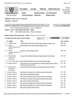
RESULTS LIST: FULL CATALOG
Records 1 - 20 of 25
Select All I Deselect All
Print/Save/Send
Create Subset
Add to List
View List
Last Browse
Modify Search
Previous Mount Desert Island (Me.) -- In art -- Exhibitions.
Subject
Current Mount Desert Island (Me.) - Maps.
Next
Mount Desert Island (Me.) -- Maps, Topographic.
Results for Mount Desert Island (Me.) - Maps.; Sorted by: Year, then Author
To change sort order, click on column heading.
Jump to #
Previous Page
Next Page
# Author
Title
Year Format
1 Garland, Larry.
Acadia National Park & Mt. Desert Island hiking and biking map.
2000 MP
2 United
Mount Desert Island region, Acadia National Park.
1995 MP
States. National Park
Service.
3 United
Boundary : Acadia National Park.
1995 MP
States. National Park
Service.
4 Mount Desert
A map of Mount Desert Island and Acadia National Park, Maine
1960 MP
Chamber of
Commerce.
5 Town of Bar Harbor. Map of M[oun]t Desert Island and Acadia National Park.
1942 MP
6 Bates, Waldron.
Path and road map of the eastern part of Mount Desert Island, Maine ;
1941 MP
Path and road map of the W
7 Mount Desert
A map of Mount Desert Island and Acadia National Park, Maine /
1938 MP
Chamber of
Commerce.
8 Bates, Waldron.
Path Map of the Eastern Part of Mount Desert Island Maine.
1917 MP
9 Bates, Waldron.
Map of Mount Desert Island, Maine.
1917 MP
10 Bates, Waldron
Path map of the Eastern Part of Mount Desert Island Maine.
1915 MP
11 Bates, Waldron.
Path Map of the eastern Part of Mount Desert Island Maine.
1911 MP
12 Bates, Waldron.
Map of Mount Desert Island Maine.
1911 MP
13 Bates, Waldron.
Path map of the Eastern Part of Mount Desert Island Maine.
1906 MP
14 Bates, Waldron.
Path Map of the Eastern Part of Mount Desert Island Maine.
1903 MP
15 Bates, Waldron.
Map of Mount Desert Island, Maine.
1901 MP
http://lms01.harvard.edu/F/PEI7PF3X7PL46L7I4LD7DFHEXAY7X3TE4NHH2PXBE25IGXC3S...
3/3/2005
HOLLIS FULL CATALOG - List of Records
Page 2 of 2
16 Bates, Waldron.
Map of Mount Desert Island, Maine /
1896 MP
17 Bates, Waldron.
Map of Mount Desert Island, Maine /
1896 MP
18 Munroe, William H.
Map of Mount Desert Island, Maine : compiled for The flora of Mt. Desert
1893 MP
Island by Edward L. Ran
19 Rand Avery Supply
Map of Eastern Steamship Co. showing approaches to Mount Desert.
1890 MP
Co.
20 Colby & Stuart (Firm) Mount Desert Island and adjacent islands : embracing the towns of Eden, 1887 MP
Mount Desert, Tremont an
Previous Page
Next Page
Select All I Deselect All
Print/Save/Send
Create Subset
Add to List
View List
Last Browse
Modify Search
SEARCH: FULL CATALOG
Browse an Alphabetical List:
Browse for:
Author (last name first)
Browse
Clear
Keywords from:
Search for:
Keywords anywhere
Search
Clear
About the HOLLIS Catalog
HARVARD LIBRARIES HOME OTHER CATALOGS E-RESOURCES CONDUCTING RESEARCH LIBRARY INFORMATION HARVARD HOME
Copyright C 2004 President and Fellows of Harvard College
http://lms01.harvard.edu/F/PEI7PF3X7PL46L7I4LD7DFHEXAY7X3TE4NHH2PXBE25IGXC3S..
3/3/2005
HOLLIS FULL CATALOG - List of Records
Page 1 of 2
7
Help
Full Catalog
Journals
Reserves
Digital Resources
Your Account
TAS
Comments
HOLLIS CATALOG
Search
Expanded Search
Command Search
Start Over
HARVARD UNIVERSITY
Previous searches
Results list
Display options
RESULTS LIST: FULL CATALOG
Records 21 - 25 of 25
Select All I Deselect All
Print/Save/Send
Create Subset
Add to List
View List
Last Browse
Modify Search
Previous Mount Desert Island (Me.) -- In art -- Exhibitions.
Subject
Current Mount Desert Island (Me.) -- Maps.
Next
Mount Desert Island (Me.) -- Maps, Topographic.
Results for Mount Desert Island (Me.) - Maps.; Sorted by: Year, then Author
To change sort order, click on column heading.
Jump to #
Previous Page
Next Page w
# Author
Title
Year Format
21 Boston and Bangor
Map of Boston & Bangor Steamship Co. showing approaches to Mount
1886 MP
Steamship Company. Desert.
22 Eastern Railroad
Map of Mount Desert Island and the coast of Maine : from Rockland to
1885 MP
Company. Passenger Gouldsborough /
Dept.
23 Eastern Railroad
Mt. Desert Island, Maine : from U.S. Coast Survey /
1880 MP
Company. Passenger
Dept.
24 Eastern Railroad
Mt. Desert Island, Maine : from U.S. Coast Survey /
1880 MP
Company. Passenger
Dept.
25 United States Coast
Mt. Desert Island, Maine /
1875 MP
Survey.
Previous Page
Next Page 1
Select All I Deselect All
Print/Save/Send
Create Subset
Add to List
View List
Last Browse
Modify Search
SEARCH: FULL CATALOG
Browse an Alphabetical List:
Browse for:
Author (last name first)
Browse
Clear
Keywords from:
Search for:
Keywords anywhere
Search
Clear
http://lms01.harvard.edu/F/PEI7PF3X7PL46L7I4LD7DFHEXAY7X3TE4NHH2PXBE25IGXC3S
3/3/2005
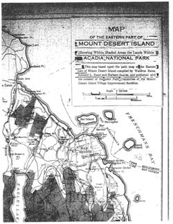
MAP
Parker Pl.
OF THE EASTERN PART OF
gape Levi
MOUNT DESERT ISLAND
Showing Within Shaded Areas the Lands Within
ACADIA NATIONAL PARK
bokout Pt.
This map based upon the path map of the Eastern
part of Mount Desert Island- compiled by Waldron Bates,
Edward L. Rand and Herbert Jaques, and published with
Hulls Cove
the consent of the joint Path Committee of the Mount
Desert Island Village Improvement Societies.
S Cove
Cove
Scale 1: 29.000
Sanoe Pt.
1/4
Mdes
Kilometers
Pond
Paradise
MIN
Bar Island
Porcupine
Bar
Harbor
Sunset
HII
McDesert
Half Moun Ponu
Abbies
ROCK
Duck M.
Retroat
Newshir
Wood) Kiry
Breakner
Madow
Ponds
dound
Great Hill
BAR
Island
alhouse
HARBOR
Brewers
Road
Mt.
462
Valley
Harbor
ogden Pt.
200
Eagle
Compass
Harbor
Luke
Str wberry (ill
Norr P1.
Great Pont
Great
Bear
Brook
Meadow
Hill
Hill
irook
275
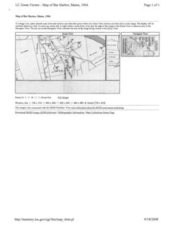
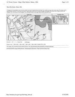
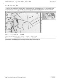
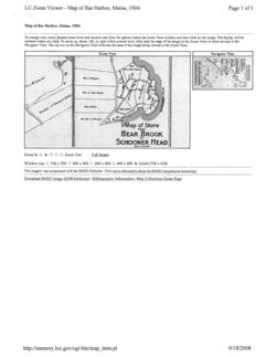
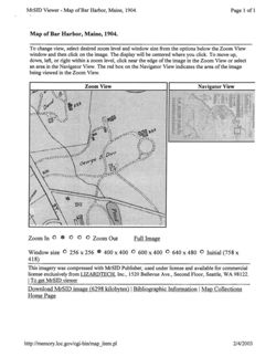
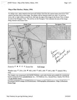
LC Zoom Viewer - Map of Bar Harbor, Maine, 1904.
Page 1 of 1
Map of Bar Harbor, Maine, 1904.
To change view, select desired zoom level and window size from the options below the Zoom View window and then click on the image. The display will be
centered where you click. To move up, down, left, or right within a zoom level, click near the edge of the image in the Zoom View or select an area in the
Navigator View. The red box on the Navigator View indicates the area of the image being viewed in the Zoom View.
Zoom View
Navigator View
Zoom In
.
Zoom Out
Full Image
Window size 256 X 256 0 400 X 400 600 X 400 640 X 480 O Initial (758 x 418)
This imagery was compressed with the MrSID Publisher. View more information about the MrSID compression technology
Download MrSID image (6298 kilobytes) | Bibliographic Information | Map Collections Home Page
http://memory.loc.gov/cgi-bin/map_item.p
9/18/2008
LC Zoom Viewer - Map of Bar Harbor, Maine, 1904.
Page 1 of 1
Map of Bar Harbor, Maine, 1904.
To change view, select desired zoom level and window size from the options below the Zoom View window and then click on the image. The display will be
centered where you click. To move up, down, left, or right within a zoom level, click near the edge of the image in the Zoom View or select an area in the
Navigator View. The red box on the Navigator View indicates the area of the image being viewed in the Zoom View.
Zoom View
Navigator View
Dean Higgins Cove
Dorr P
Gardiner
Zoom In
Zoom Out
Full Image
Window size
256 X 256
400 X 400 600 x 400 640 X 480 Initial (758 x 418)
This imagery was compressed with the MrSID Publisher. View more information about the MrSID compression technology.
Download MrSID image (6298 kilobytes) I Bibliographic Information | Map Collections Home Page
http://memory.loc.gov/cgi-bin/map_item.p)
9/18/2008
LC Zoom Viewer - Map of Bar Harbor, Maine, 1904.
Page 1 of 1
Map of Bar Harbor, Maine, 1904.
To change view, select desired zoom level and window size from the options below the Zoom View window and then click on the image. The display will be
centered where you click. To move up, down, left, or right within a zoom level, click near the edge of the image in the Zoom View or select an area in the
Navigator View. The red box on the Navigator View indicates the area of the image being viewed in the Zoom View.
Zoom View
Navigator View
x
Zoom In
Zoom Out
Full Image
Window size
256 X 256
400 X 400 600 x 400 640 x 480 C Initial (758 x 418)
This imagery was compressed with the MrSID Publisher. View more information about the MrSID compression technology.
Download MrSID image (6298 kilobytes) | Bibliographic Information I Map Collections Home Page
http://memory.loc.gov/cgi-bin/map_item.p)
9/18/2008
LC Zoom Viewer - Map of Bar Harbor, Maine, 1904.
Page 1 of 1
Map of Bar Harbor, Maine, 1904.
To change view, select desired zoom level and window size from the options below the Zoom View window and then click on the image. The display will be
centered where you click. To move up, down, left, or right within a zoom level, click near the edge of the image in the Zoom View or select an area in the
Navigator View. The red box on the Navigator View indicates the area of the image being viewed in the Zoom View.
Zoom View
Navigator View
240
Francis
be
251
a
Francis
Mrs.
Bea
Map of Shore
FROM
BEAR BROOK
TO
SCHOONER HEAD
Zoom In
Zoom Out
Full Image
Window size 256 X 256 400 x 400 600 x 400 640 x 480 O Initial (758 x 418)
This imagery was compressed with the MrSID Publisher. View more information about the MrSID compression technology.
Download MrSID image (6298 kilobytes) | Bibliographic Information | Map Collections Home Page
http://memory.loc.gov/cgi-bin/map_item.p)
9/18/2008
MrSID Viewer - Map of Bar Harbor, Maine, 1904.
Page 1 of 1
Map of Bar Harbor, Maine, 1904.
To change view, select desired zoom level and window size from the options below the Zoom View
window and then click on the image. The display will be centered where you click. To move up,
down, left, or right within a zoom level, click near the edge of the image in the Zoom View or select
an area in the Navigator View. The red box on the Navigator View indicates the area of the image
being viewed in the Zoom View.
Zoom View
Navigator View
Zoom In
Zoom Out
Full Image
Window size O 256 X 256 O 400 X 400 O 600 X 400 O 640 X 480 Initial (758 X
418)
This imagery was compressed with MrSID Publisher, used under license and available for commercial
license exclusively from LIZARDTECH, Inc., 1520 Bellevue Ave., Second Floor, Seattle, WA 98122.
I
To get MrSID viewer
Download MrSID image (6298 kilobytes) I Bibliographic Information | Map Collections
Home Page
http://memory.loc.gov/cgi-bin/map_item.pl
2/4/2003
MrSID Viewer - Map of Bar Harbor, Maine, 1904.
Page 1 of 1
Map of Bar Harbor, Maine, 1904.
To change view, select desired zoom level and window size from the options below the Zoom View
window and then click on the image. The display will be centered where you click. To move up,
down, left, or right within a zoom level, click near the edge of the image in the Zoom View or select
an area in the Navigator View. The red box on the Navigator View indicates the area of the image
being viewed in the Zoom View.
Zoom View
Navigator View
241
Dair
Zoom In
Zoom Out
Full Image
Window size 256 X 256 O 400 X 400 O 600 X 400 O 640 X 480 Initial (758 X
418)
This imagery was compressed with MrSID Publisher, used under license and available for commercial
license exclusively from LIZARDTECH, Inc., 1520 Bellevue Ave., Second Floor, Seattle, WA 98122.
|
To get MrSID viewer
Download MrSID image (6298 kilobytes) I Bibliographic Information | Map Collections
Home Page
http://memory.loc.gov/cgi-bin/map_item.pl
2/4/2003
FIASHBACK
Peculiar Work
Why this man took a thousand walks with AMC By LARRY ANDERSON
ll this lifetime of peculiar
nock, a book MacKaye owned and often
der, then, his frustration if he wasn't able
A
work will be lost when I am
consulted, used one of Chamberlain's
to carry out his work: On one AMC trip
gone," Edward C. Cham-
maps to support the conclusion that
to Moosilauke in 1890, "it rained every
berlain lamented in Ap-
Monadnock offered that sweeping re-
day, and I saw nothing.
Others went
palachia in 1922, "for no
gional glance. The book, written by Mas-
for a good time and had a good time,
one else understands just how to use it
sachusetts conservationist and long-time
rain or shine. To me it was a dead loss."
or would have patience to do it."
AMC leader Allen Chamberlain (a friend,
On a successful outing, Chamberlain
An AMC member and self-trained
submitted his observations to three tests:
surveyor who died in 1935 at the age of
"Is the angle correct? Is the description
90, Chamberlain's "peculiar work" was
correct? Is there any similar object near-
compiling and drawing meticulous
ly in line that might be mistaken for it?"
panoramas from some of New England's
He usually repeated this creed in the terse
best-known elevations-from Boston's
articles in Appalachia that accompanied
State House to the summit of Mount
his maps, which were drawn in an ex-
Washington. His aim over the course of
acting and distinctive pen-and-ink style.
more than 50 years of careful, solitary,
Four horizontal panels, stacked one atop
and unpaid work was to chart accurate-
the other, depict the full 360 degrees of
ly the hills, mountains, large buildings,
the horizon, with outlines of dozens of
and other prominent features visible
features sketched in. His panoramas, he
from dozens of observation points
observed, "are not based on photographs,
throughout the region.
and, intentionally, are not even accurate
In Chamberlain's orderly mind's eye,
sketches of the views. They are intended
the landscape of New England was COV-
as guides to views, and are purposely dis-
ered with a spider web of sightlines. Over
torted in order to better enable visitors to
the years he filled 200 field notebooks
identify the points shown."
with 10,000 angles from 200 lookout
These panoramas represented only one
points in the six New England states. By
aspect of his cartographic interests. Dur-
the time of his death, he had completed
"No one else
ing his more than half-century with
52 panoramic maps and gathered the
AMC, he compiled more than 850 de-
measurements for 18 more. Some of the
understands
tailed maps of the estimated 1,000 club
panoramas were published in Appalachia;
walks in which he participated, mostly
the rest are filed in the AMC library.
just how to use this
in the greater Boston area. To most, he
Chamberlain's work recently came to
was known as "the active and silent el-
mind when I gave a talk about Benton
work, or would have
derly man who accompanied many of
MacKaye, who first proposed the Ap-
the walking parties, mapping in detail
palachian Trail. A member of the audi-
patience to do it."
the routes of the excursions as he went
ence asked whether Maine's Katahdin
along," Allen Chamberlain wrote in Ap-
could be seen from the summit of New
but no relation), confirmed that the vis-
palachia when his friend died. "Those
Hampshire's Mount Monadnock, well
ible point in Maine was not Katahdin,
who enjoyed his intimacy knew him to be
over 200 miles distant. My interrogator
but the modest, and much more south-
a genial companion and a wittily enter-
cited a 1949 article by MacKaye as the
ern, 692-foot Mount Agamenticus.
taining talker." And knew that his maps,
source of this assertion.
"Many a case of mistaken identity has
representing the amateur spirit in its es-
In fact, MacKaye had made no such
been rectified through his careful obser-
sential form, were truly a labor of love.
claim, but had written that points in each
vations," wrote one admirer of Edward
-Larry Anderson is a writer and AMC
of the six New England states were visible
Chamberlain's labors. Before venturing
member whose biography of Benton
from Monadnock. And I suspect he may
out, the mapmaker would spend days
MacKaye will be published this year by
have relied, at least indirectly, on Cham-
computing angles, making sketches, and
Johns Hopkins University Press.
berlain's scrupulous work to support his
studying photographs and even ads pub-
(To view Chamberlain's maps, call the
statement: Annals of the Grand Monad-
lished by hotels and railroads. No won-
AMC library: 617-523-0655 ext. 329.)
18 AMC OUTDOORS MAGAZINE
MAY 2002
Harpers Ferry Center: Eminent NPS Photographers
Page 1 of 1
National Park Service
U.S. Department of the Interior
Harpers Ferry Center
NPS Photos > Search the Collection > Photo Record Detail > Eminent Photographer
Eminent National Park Service Photographers
George A. Grant (1929-1954)
George A. Grant was the first Chief Photographer for
the NPS. He was hired by Horace M. Albright in 1929
to create a documentary file of images for use by
the Service in reports, interpretive projects,
education, and public information. Grant, until his
retirement in 1954, created approximately 30,000-
40,000 images of NPS areas. These images include -
- but are not limited to -- the following: events,
George Alexander Grant.
personnel, architecture, archaeology, stamps, and
Native Americans. Because of their significance to
NPS history, these images have been included in the
National Park Service Historic Photograph Collection.
About Eminent NPS Photographers
The term "Eminent Photographer" is used to credit
the individuals who have created a large body of
work that documents our National Parks, the
National Park Service, and the Cultural and Natural
Resources found throughout the National Park
System. Although their photographs have been used
in books, papers, and movies for over 70 years, the
photographers of the National Park Service are often
overlooked when credit is due. Most often credit
lines appear as "National Park Service Photograph",
"Courtesy of the National Park Service", or simply
"NPS Photo."
These eminent photographers span the history of
the National Park Service since the first Chief
Photographer, George A. Grant, was hired in 1929 to
the present day.
Author: Harpers Ferry Center
Date: 02/18/2010
http://home.nps.gov/applications/hafe/hfc/eminent.cfm?Photo_code=gran
2/18/2010
Page 1 of 2
Re: Dorr, of course
From
To
Date Tue, 16 Jun 2009 14:01:44 -0400
Attachments 324.jpg [ 1.36 MB]
Hi Ron,
Thanks for the heads up about the COA report. I emailed the professor to
see if I can get a copy.
We have the following maps in which you may be interested:
-Colby/Stuart Atlas (1881 &1884)- Sawtelle Box 107
-Map: Part of Bar Harbor, 1903 by the Bar Harbor Summer Residents
Association (MC-1, Dr 7, F4)
-MAP OF BAR HARBOR, MAINE - A. STROUD RODICK, BAR HARBOR COTTAGES FOR RENT,
1907 by the Bar Harbor Summer Residents Association (MC 1, D7, F5)
-MAP OF BAR HARBOR, MAINE, FRED C. LYNAM & CO. REAL ESTATE AND INSURANCE no
date (MC 1, D7, F5)
-MAP OF PROPERTY BELONGING TO MRS. JOHN MABKOE, GEO. B. DORR AND OTHERS,
BAR
HARBOR, HANCOCK CO, 1907, (MC 1, D7, F5) Checked. Use as illustration
1907+1906
We also have some historic park maps that are not listed in my spreadsheet,
We can look at these quickly to see if they are helpful.
In the meantime, I've attached a map of Bar Harbor to whet your appetitive.
(See attached file: 324.jpg)
John McDade
Museum Technician
Acadia National Park
P.O. Box 177
Bar Harbor, ME 04609
(207)288-8729
eppster2@myfairpo
int.net
To
06/15/2009 03:54
PM CC
Subject
Re: Dorr, of course
Hi John,
I'm currently in the waiting mode regarding a meeting that is to be
scheduled in downtown B.H. or else I'd suggest a particular date and
time to meet with you.
But I thought I'd indicate a couple of points of interest that you
https://webmail.myfairpoint.net/hwebmail/mail/message.php?index=1070
6/16/2009
Page 2 of 2
could pursue prior to my arrival:
1. Hancock County Atlas, circa 1881 or earlier. This may be the atlas
by George N. Colby & Co., published by Halfpenny & Stuart oif
Ellsworth. I'm trying to identify the extent of the Dorr property
originally purchased in 1868 and later enlarged prior to the completion
of Oldfarm in 1880. Any other maps from the 1874-1889 of the eastern
half of the Island, perhaps undertaken by the U.S. Geological Survey?
2. I have a reference to a 1904 and 1927 map of Bar Harbor developed by
the Bar Harbor Summer Residents Association. Is this in your database?
I've just read a paper completed by several COA students wherein you
are quoted as a resource. The study of local attitudes toward the
purchase and segregation of conservation lands on MDI is very well done
and should be considered as an addition to your archive.
See you soon.
Ron Epp
Quoting John_McDade@nps.gov:
>
> Ron,
>
> I'm back up at Acadia. I hope you are doing well.
>
> We shipped several boxes from the archives down to Boston last week.
While
> processing things before they left an archivist came across a business
card
> for a mentalist (or some type of fortune-teller, I don't remember the
exact
> title). It looked to be from the Dorr era, and I would bet it was his.
> Had you seen this?
>
> I told Liz to flag it in case you are interested.
>
> -John
>
> John McDade
> Museum Technician
> Acadia National Park
> P.O. Box 177
> Bar Harbor, ME 04609
> (207)288-8729
>
Ronald H. Epp, Ph.D.
47 Pondview Drive
Merrimack, NH 03054
(603) 424-6149
eppster2@myfairpoint.net
https://webmail.myfairpoint.net/hwebmail/mail/message.php?index=1070
6/16/2009
s
GROUNDS
map shoung
charlton Yariall
residence at
JA. Murray
Disston
Word East Harber
N.E.
Harbot
927
came
Gall Grounds
W-W
Lewh
W.
Smiler
W. J. Turner
Distican
@
D
Inn
Greens
Harborsic
J.
Club C
lunis
g
Camell
Linoln
G W. Pepper
Termon
ON Rethand Harth
Cromwell
Tennis
0
B
w
Club
@
c
Gano wann
Prest N.E.
9
P.O
0
H. Perbany
Harbor
Swiming
Neighbor
J.H. Carte:
@ Saurach Use
Pool
three Kinder
Clifton
R
House
Kasha
Win
m
Dr.
Dropy
House
THE
S leader
Heney Parkmen
@ (9
©
Dom os Milliken
w Ust x
com Vaughan
depends
W. Fraser
Viewer Controls
Toggle Page Navigator
P
Toggle Hotspots
H
Toggle Readerview
V
Toggle Search Bar
S
Toggle Viewer Info
I
Toggle Metadata
M
Zoom-In
+
Zoom-Out
-
Re-Center Document
Previous Page
←
Next Page
→
[Series III] Maps
| Page | Type | Title | Date | Source | Other notes |
| 1-6 | Website | Maps of Acadia National Park | 12/03/2002 | https://www.loc.gov/collections/national-parks-maps/articles-and-essays/maps-of-acadia-national-park/?fa=partof%3Acatalog: original web address no longer accessible | - |
| 7 | Email from Bill Horner to Peter Johnson, cc Ronald Epp: CHAPMAN FIRM MAP COLLECTION | 07/28/2011 | Ronald Epp | - | |
| 8-27 | List | Instructions and Partial Breakdown: To be used with main map list | 2011 | Chapman Archive Map Room Index | - |
| 28 | Notes | Box 555 Maps | 2015 | Ronald Epp | - |
| 29 | Map | Map Drawn by G.B.Dorr: Date and Source unknown | - | - | - |
| 30-31 | Journal Article | Cultural Landscape Report for the Historic Hiking Trail System of Mount Desert Island: Title Page and Map | - | Pathmakers | Note: One of many MDI maps printed in Pathmakers |
| 32 | Website | Digital Sanborn Maps 1867-1970: An Essential Record of U.S. Growth and Development | - | from http://www.chadwyck.com | - |
| 33 | Book Excerpt | Table of Contents | - | Fire Insurance Maps: Their History and Applications / Diane L. Oswald | - |
| 34-35 | Website | GEOSTAT: History of Sanborn Fire Insurance Maps | 03/21/2003 | https://fisher.lib.virginia.edu/collections/maps/sanborn/web/details.html | - |
| 36-37 | Website | Mapmaker Jane Crosen - About the artist | 12/17/2016 | https://www.mainemapmaker.com/about_the_artist.html#:~:text=Mapmaker%20Jane%20Crosen%20%2D%20About%20the,of%20the%20Maine%20Atlas%20%26%20Gazetteer. | - |
| 38-40 | Website | Mount Desert Island Maps | 03/03/2005 | Hollis Full Catalog List of Records: original web address no longer accessible | - |
| 41-47 | Maps | Map of Bar Harbor, Maine, 1904. | 09/18/2008 | From lhttps://www.loc.gov/item/98687164/: original web address no longer accessible | - |
| 48 | Journal Article | Peculiar Work: Why this man took a thousand walks with AMC / Larry Anderson | 2002 | Flashback: AMC Outdoors Magazine | - |
| 49 | Website | Harpers Ferry Center: Eminent NPS Photographers: George A. Grant | 02/18/2010 | https://www.nps.gov/people/george-a-grant.htm | - |
| 50-51 | Email from John McDade to Ronald Epp: Re: Dorr, of course | 06/16/2009 | Ronald Epp | - | |
| 52 | Map | Bar Harbor Maine | - | - | - |
| 53 | Map | Maps by George B. Dorr showing N.E Harbor | - | - | - |

