
From collection Creating Acadia National Park: The George B. Dorr Research Archive of Ronald H. Epp

Page 1
Page 2
Page 3
Page 4
Page 5
Page 6
Page 7
Page 8
Page 9
Page 10
Page 11
Page 12
Page 13
Page 14
Page 15
Page 16
Page 17
Page 18
Page 19
Page 20
Page 21
Page 22
Page 23
Page 24
Page 25
Page 26
Page 27
Page 28
Page 29
Page 30
Page 31
Page 32
Page 33
Page 34
Page 35
Page 36
Page 37
Page 38
Page 39
Page 40
Page 41
Page 42
Page 43
Page 44
Page 45
Page 46
Page 47
Page 48
Page 49
Page 50
Page 51
Page 52
Page 53
Page 54
Page 55
Page 56
Page 57
Page 58
Page 59
Page 60
Page 61
Page 62
Page 63
Page 64
Page 65
Page 66
Page 67
Page 68
Page 69
Page 70
Page 71
Page 72
Page 73
Page 74
Page 75
Page 76
Page 77
Page 78
Page 79
Page 80
Page 81
Page 82
Page 83
Page 84
Page 85
Page 86
Page 87
Page 88
Page 89
Page 90
Page 91
Page 92
Page 93
Page 94
Page 95
Page 96
Page 97
Page 98
Page 99
Page 100
Page 101
Page 102
Page 103
Page 104
Page 105
Page 106
Page 107
Page 108
Page 109
Page 110
Page 111
Page 112
Page 113
Page 114
Page 115
Page 116
Page 117
Page 118
Page 119
Page 120
Page 121
Page 122
Page 123
Page 124
Page 125
Page 126
Page 127
Page 128
Page 129
Page 130
Page 131
Page 132
Page 133
Page 134
Page 135
Page 136
Page 137
Page 138
Page 139
Page 140
Page 141
Page 142
Page 143
Page 144
Page 145
Page 146
Page 147
Page 148
Page 149
Page 150
Page 151
Page 152
Page 153
Page 154
Page 155
Page 156
Page 157
Page 158
Page 159
Page 160
Page 161
Page 162
Page 163
Page 164
Page 165
Page 166
Page 167
Page 168
Page 169
Page 170
Page 171
Page 172
Page 173
Page 174
Page 175
Page 176
Page 177
Page 178
Page 179
Page 180
Page 181
Page 182
Page 183
Page 184
Search
results in pages
[Series III] Travels-Boston to San Francisco 1904-Sierra Nevada History
TRAVELS Boston to San Fromisco!9a
Sierra Nevada History.
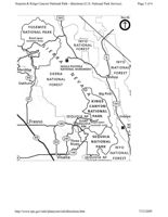
Sequoia & Kings Canyon National Park - directions (U.S. National Park Service)
Page 3 of 4
395
North
YOSEMITE
NATIONAL PARK
Road open
summer only.
INYO
s
NATIONAL
FOREST
6
INYO
DEVILS POSTPILE
NATIONAL
Mariposa
NATIONAL MONUMENT
SIERRA
FOREST
49
Bishop
NATIONAL
Oakhurst
FOREST
A
A
Big Pine
41
KINGS
395
CANYON
NATIONAL
SEQUOIA NF
PARK
Indeper
Fresno
GIANT
180
TSEQUOIA
Road open
NM
summer only.
MA
HIS
L
99
SEQUOIA
245
63
Three
NATIONAL
Rivers
PARK
INYO
198
NATIONAL
8
Visalia
SEQUOIA NF
FOREST
http://www.nps.gov/seki/planyourvisit/directions.htm
7/13/2009
Templer and Playgrounds: The Sierra (lub in the W; derners.
Anne 7. Hyde
I
1904 an enthusiastic Sierra Club member penned
The photographs and their captions, demonstrating
the following words to describe a photograph he
a clear change in attitudes toward nature in the years
had taken of Yosemite Valley while enjoying the
between 1901 and 1922, are contained in albums kept
annual Sierra Club Outing:
by California Sierra Club members to commemorate
Sunday morning, too!-and we stood at the portals of one
their Annual Outing to the mountain wilderness.
of the grandest natural cathedrals on the Pacific Slope. From
Founded in 1892 by John Muir and a group of Bay Area
the richly carved granite choir galleries came the joyous music
professionals with the purpose of "exploring, enjoying,
of many waters, and the deep organ tones of full throated
and rendering accessible the mountain regions of the
waterfalls pealed forth ever and anon as we threaded its aisles.
Pacific Coast,"3 the Sierra Club introduced the Annual
Outing in 1901. Each summer the club organized a
His photograph demonstrates the same reverence.
month-long visit to the wilderness, generally in the
Graceful pine trees frame a vision of towering granite
California Sierra. The most popular spots included
walls split by a tumbling cataract. No human presence
Yosemite and its surrounding area and the region that
dares to break the sublime spell.
now encompasses Sequoia and Kings Canyon national
Seventeen years later, two exuberant participants in
parks According to the officers of the club, "This Out-
a 1921 Outing recorded their adventures in a different
ing is intended to awaken an interest in and afford an
tone. Under a photograph of a white mule standing in
exceptional opportunity for visiting the most wonderful
a mountain snow field with legs splayed and nostrils
and picturesque High Sierra Region of California."
flared, they wrote:
In 1901, the Sierrans recognized that their first Outing
Has anybody here seen Blackie
was a unique event. The announcement to the general
He wandered off the trail
membership of the expedition to Yosemite stated,
He took our dunnage with him
We've searched without avail.
"Never before has there been presented such an oppor-
tunity for visiting so comfortably and enjoyably this
We're in the High sierra
wild, rugged, and romantic region of our High Sierra."5
We've no beds, no food.
We trusted that white Blackie
Each year, eighty to two hundred Sierrans of varying
We thought he was good.
ages, occupations, and outdoor experience set off for
Has anybody here seen Blackie
He bears a great white pack.
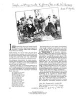
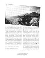
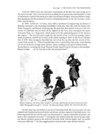
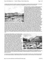
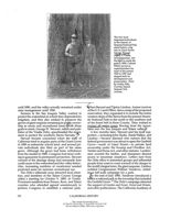
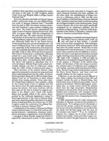
(Above) "After." Photograph by H.C. Stinchfield (1919).
If should come across him,
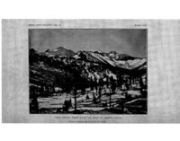
(Right) "Summit of Mount Gould 13,300 feet." Photograph
Please will you send him back.2
by J. LeConte (1901).
208
CALIFORNIA HISTORY, 101.66,*3 (1987)
This content downloaded from
137.49.125.110 on Mon, 14 Sep 2020 13:48:18 UTC
All use subject to https://about.jstor.org/terms
the wilderness, accompanied by a platoon of Chinese
or black cooks, an army of mules, and several tons of
gear. The pattern of these trips varied little. The club
set up a main base camp, and a wide range of side
expeditions took off from there. The participants in the
outings kept voluminous journals describing every as-
pect of the event, and each year they took hundreds
of photographs which they placed in carefully cap-
tioned albums
Over the years, these albums show distinct changes
in the way the Sierrans photographed themselves and
the surrounding wilderness. The photographs fall into
three general categories: nature as awesome, a sublime
temple to approach with humility; nature being con-
C. quered; and nature conquered, a gigantic playground.
In general, these categories develop chronologically,
the first present in 1901 and fading by 1910, the second
appearing by 1907 and continuing through 1922, and
the third present only after 1915
By the late nineteenth century, the art world's search
for the sublime and the ideals of Romanticism and Tran-
scendentalism had begun to move Americans from the
contemplation of paintings of dramatic landscapes in
art galleries and drawing rooms to the observation of
real landscapes. Tourists gaped at towering mountains
and peered into awful chasms from well-appointed
Pullman cars or observation decks, but still, few Ameri-
cans had ventured into the wilderness-and certainly
not in the numbers or for the long time that the Sierra
Club proposed. Some Sierra Club members preparing
for the early Outings worried that their love of nature
would place them in the category of eccentric. Others
took pride in their eccentricity, exclaiming, "There are
those who believe that in this modern day the love of
nature-wild nature-is vanishing from the world.
Probably they read their Thoreau of a vacation on the
verandas of summer resorts; at all events, they are not
members of the Sierra Club."6 The Sierrans could look
for praise for their undertaking from President Theo-
dore Roosevelt, whose advocacy of the "strenuous life"
as an antidote to "flabbiness" and "slothful ease" en-
couraged a wide variety of vigorous outdoor recreational
activity>
Even for the Sierrans, though, life in the outdoors
was unfamiliar. Many described themselves as com-
plete "tenderfeet" and admitted their need for an initi-
ation into the ways of the wild life. One remembered,
"To get into our bags was the work of a few moments
Ann F. Hyde is a doctoral candidate in History at the
University of California, Berkeley. Her thesis is on the resort
hotels of the late nineteenth and early twentieth centuries.
210
CALIFORNIA HISTORY
This content downloaded from
137.49.125.110 on Mon, 14 Sep 2020 13:48:18 UTC
All use subject to https://about.jstor.org/terms
and a tired mountaineer needs no sedatives. But the
extreme novelty of the situation assisted by the villain-
ous unevenness of the ground and by prowling mules,
One must have the fullest use of the lungs and the
had the effect of keeping at least one 'tenderfoot' awake
loosest corset is some impediment to the breathing As
for some time." Later that night this particular brave
ordinarily worn they are impossible."
Sierran roused the entire camp in a loud brawl with a
Outing photographs from the early years demon-
mule, unfortunately mistaken for a wild grizzly bear.
strate the tentativeness of the ties the Sierrans felt to
Another clue to the novelty of the situation appears
the natural world. Awe before what John Muir called
in the concern about proper attire for women. The an-
"a window opening into heaven, a mirror reflecting the
nouncement of the 1902 Outing advised, "Skirts can
Creator" was the dominant mood. Joseph LeConte, a
be short, no more than half way from knee to ankle,
famous geologist and experienced outdoorsman) rarely
and under them can be worn shorter, dark, colored
took pictures of people in the wilderness When he
bloomers." The writer added, "It would be unsafe to
did, the people appear out of place, not sure how to
ride other than astride on portions of the trip. and no
behave. "Dinner in Camp," for example, depicts an
side saddles can be obtained." As a helpful hint about
elegant dinner party which seems, incidentally, to have
hiking and climbing garb, and to assure critics that
taken place in the Yosemite wilderness. Several ele-
proprieties would be observed. one writer suggested,
gantly dressed men and women sit stiffly at a table
"For high climbing many ladies wear a skirt of moderate
covered with a table cloth and set with china and silver.
length until out of sight of the main camp and then
No chandelier hangs above, and a pine bough decorates
leave the skirt under a rock Women SO rarely
the table, but these are the only concessions to the
engaged in such rigorous activities that a writer for
wilderness.
Outing, an early sporting magazine, broached the del-
This discomfort evolved out of the context in which
icate subject of underwear in print. She stated ada-
the appreciation of wild nature developed Che nine-
mantly, "No one should climb mountains in corsets.
teenth-century transformation in the American view of
wilderness from an enemy to be subdued to the embod-
iment of the sublime brought with it a sense of hesita-
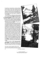
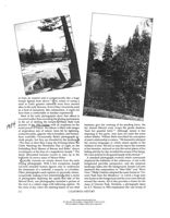
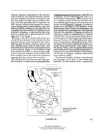
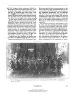
(Left top) "The Nine at Their Base Camp." Photograph
tion. The wilderness became a shrine where nature
by William F. Bade (1904).
lovers expected to be impressed intimidated, and
awed. "Here the appropriate mood is worship," wrote
(Left) "Mist Falls." Photograph by J. Leconte (1901).
one visitor to Yosemite. It is John Muir's exquisite in-
(Above) "King's Canyon." Photograph by L.T. Parsons
sight to the effect that the vale of the Yosemite looked
SEPTEMBER 1987
211
This content downloaded from
137.49.125.110 on Mon, 14 Sep 2020 13:48:18 UTC
All use subject to https://about.jstor.org/terms
at from its western end is architecturally like a huge
temple lighted from above." " The notion of eating
a
meal in God's greatest cathedral must have seemed
alien to the early Sierrans. Even if they viewed the meal
as a kind of sacrament, like communion, it could not
have been a comfortable or familiar experience.)
Most of the early photographs show that nature is
in control rather than recording the Outing participants
1904
in the act of defiling the temple.William Bade took
pictures of the 1904 Outing with an emphasis on the
luminary give fair warning of his pending leave, the
awful power of nature. His album is filled with images
fair damsel Merced coyly wraps the gentle shadows
of stupendous acts of nature: trees hit by lightning,
'bout her graceful form." Although nature is less
avalanche paths, gigantic rifts in boulders, and tremen-
imposing in this guise, man does not enter the scene
dous waterfalls. Occasionally, Bade's photographs in-
unless bidden. William Bade described his conception
clude people, but they are dwarfed by the landscape
of man's relationship to nature, "We learned to interpret
"The Nine at their Base Camp the Evening before the
the various languages in which nature speaks to the
Climb Watching the Wonderful Play of Light on the
children of men. She led us step by step to the summits
Forbidding Rock Masses of Banner and Ritter" shows
of her beauties, seduced us into the secret places of her
worshippers at the base of a magnificent temple. 12 The
hiding and day by day revealed the arcana of her being.
dimly silhouetted humans crouch to stare up at the
We were acolytes in the grand temple of the eternal." 4
brilliantly lit snowy mass of Mount Ritter.
A standard photograph evolved which consciously
Typically, humans are simply absent from the early
displayed the sublimity of the wilderness. A tree is the
Outing photographs. With a few exceptions, Joseph
foreground provides perspective, and the immense
LeConte included human figures only to underscore
landscape fades into the background. Joseph LeConte
the immensity of a waterfall, a sequoia, or a boulder.
mastered this composition in "Mist Falls" and "River
Other photographs used captions to personify nature,
View." Philip Carleton adopted the same format in "Un-
occasionally making it less intimidating, After a series
icorn Peak from the Meadows," in which a huge pine
of photographs depicting the rapids and falls of the
tree looms in the foreground and the river roars directly
Merced River, one photographer included a picture of
toward the viewer. All of this provides a frame for the
the river in a calmer stage with following caption: "At
mass of Unicorn Peak. Similarly, a photograph taken
the close of day when the slanting beams of our chief
by E.T. Parsons in 1902 emphasizes the vast sweep of
212
CALIFORNIA HISTORY
This content downloaded from
137.49.125.110 on Mon, 14 Sep 2020 13:48:18 UTC
All use subject to https://about.jstor.org/terms
little briar and brush, my face was red with sunburn,
and I once annexed eight freckles to my nose."
Kings Canyon as it stretches away from the tree in the
The physical pleasures of wilderness life gradually
foreground Such photographs echo the conventions
came to occupy more attention than spiritual lessons
of nineteenth-century paintings, in which the blasted
in the journals of Outing participants One Sierran
tree in the foreground of a landscape demonstrates
exulted in 1909, "To walk over hard snowdrifts under
the power of God's whimsy. Just as in a Bierstadt or
a hot sun, to burn at midday and shiver at night
Cole painting, in which humans rarely appear except
all without taking cold: to be a barbarian and a commu-
as foils to demonstrate the magnificent scale of nature,
nist, a homeless and roofless vagabond, limited to one
the photographs are composed to emphasize vastness
gown or suit of clothes all of these breaches of
and power, with sheer cliffs looming up from valley
convention became commonplaces in such a life as this,
floors and. canyons fading into endless ranges of
part of the adventure.** Another described the joys
mountains.
of the 1907 Outing: "The weak grew strong and the
strong invincible. Men and women made knapsack
trips, young girls tramped over a hundred miles in a
B
week, and in all the company, never a creature, even
eginning about 1907, however, the Sierrans
to the horses, was ill." These humans felt at ease in
seemed to take nature for granted, feeling
the wilderness and little concerned with the awesome
more at ease in their wild surroundings with
forces nature could unleash upon them.
each passing summer. "I laugh now when I think of
The new focus had a competitive aspect, as Sierrans
those first trips wrote one woman in 1909 > Of
grew increasingly intent on conquering the challenges
course I wore a long skirt, a shirt waist, straw hat and
of the wilderness Using their newly discovered phys-
veil, kid gloves and low shoes and was as uncomfort-
ical prowess, they tackled nature and exulted in their
able as a woman could be. My skirt caught on every
victories. A 1907 photograph depicts a group of people
standing squarely on the summit of a mountain) Both
men and women smile proudly and plant their feet
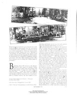
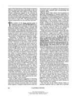
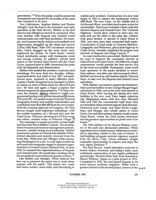
(Far left) "Unicorn Peak from the Meadows." Photograph
by Philip Carleton (1907).
firmly on the peak. The caption reads, "Conquered
Dana!-Yes, to be sure, for this constitutes the roll call
(Left) "River View." Photograph by J. Leconte (1901).
that was taken on the summit." A similar photograph
in the same album is captioned "Just holding down
(Above) "Chow Line." Photograph by E.T. or M.R. Parsons (1909).
Mount Hoffman for a while" and shows a large group
SEPTEMBER 1987
213
This content downloaded from
137.49.125.110 on Mon, 14 Sep 2020 13:48:18 UTC
All use subject to https://about.jstor.org/terms
snow on a rocky slope. A series of photographs by
Elizabeth Crispin emphasized the rough terrain cov-
ered by the hikers, and "Coming Down Off Mount
of hikers resting contentedly on the summit, relaxed
Conness," a 1919 photograph. depicts a group inching
and smiling in their lofty and barren surroundings. A
its way down a sheer rock face. Marion Parsons de-
woman who mastered Mount Rainier commented on
scribed her experiences on a similar endeavor on South
her satisfaction, "Only a mountaineer can appreciate
Kaweah Peak, "It seemed the wildest of follies to stir
the sense of exhilaration with which we contemplated
a hair breadth from the hand or foot hold which had
the vast expanse of the crater and told ourselves that
proved firm toward the untried possibilities that the
we had conquered the kingliest among all the moun-
next step held. Slowly and with greatest care. we crept,
tains of the United States."
crawled, and clambered along the knife edge." For
Mount Rainier may have been the "kingliest," but
these climbers, the wilderness provided challenges that
Mount Whitney reigned as the highest mountain in the
simply had to be met.
continental United States, and it was a Sierra Club favo-
The new obsession with conquering nature appears
rite. A few Sierrans climbed it in the early years, but
even in photographs of the landscape. Gone are the
they never attempted it en masse or took pictures of
carefully framed images of nature's grandeur; in their
themselves on the summit In 1916. Jessie Treat wrote
place appear photographs of single peaks, precisely
proudly, "On Wednesday morning two hundred left
identified and measured. The captions provide intor-
for Crabtree Meadows base camp to ascend Mount
mation, not poetry: "On top of Mount Brewer, 13,577
Whitney the following day. One hundred seventy-five
feet," "Looking Up Bubbs Creek of Evolution Peak,"
reached the summit, the largest party of mountaineers
with peaks named and measured These photographs
ever registered there." A few years later Perry Evans
show little interest in pictorial qualities
photographed the trip up Whitney. He took ten shots
Generally the photographers of the years after 1910
of the group lolling about on the summit and ten shots
did not concern themselves with scenery but docu-
of the surrounding scenery and compiled a complete
mented instead the presence of man in nature. The
list of those who made it up in the order of their arrival
on the summit
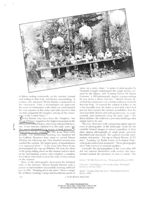
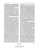
(Above) "We Take Turns Serving." Photograph by Parsons (1912).
Many of the photographs showcased the technical
skills of the Sierrans. Marion Randal Parsons took a
(Top right) "Snowballing on the Fourth of July." Photograph
picture of club members successfully crossing a difficult
by Marion Persons (1912).
pass in 1912. "Treading down the snow" shows a single
(Right) "Treading Down the Snow." Photograph by Marion
file of hikers crossing a steep and treacherous patch of
Parsons (1912).
214
CALIFORNIA HISTORY
This content downloaded from
137.49.125.110 on Mon, 14 Sep 2020 13:48:18 UTC
All use subject to https://about.jstor.org/terms
Sierrans now took pictures of their base camps and of
their daily activities, no longer disturbed by the idea
that they were defiling the sanctity of nature. Either
bered by the austere grandeur of the scene, we quietly
Marion or E.T. Parsons captured club members waiting
withdrew in detached groups and slowly pondered the
hungrily in their vast "chow line" and snapped a shot
awe-inspiring spot."
of the serving table, gaily decorated with Japanese lan-
terns and the grimy but smiling faces of garland-be-
decked Sierrans. People eating, washing, swimming,
sleeping, and groaning uphill fill the images of this era.
B
V 1909 the rhetoric of the sublime was rare
Recognizing the novelty of their adventure, the Sier-
both in print and on film. The Sierrans now
rans found their stay in the wilderness exhilarating
conquered nature's wonders instead of wor-
rather than spiritually moving. Marion Parsons's 1912
shipping them. Certainly some of the earlier ideals exist
photograph entitled "Snowballing on the Fourth of
in the photographs of waterfalls and mountain lakes,
July" illustrates some of the new qualities. No longer
but in all the albums from the second decade of the
did people feel obligated to stare off into the scenery
twentieth century these pictures are scattered among
and wonder about lessons to be learned from the inspir-
examples of the newer style of Sierra Club photography.
ing sight. Now Sierrans could ignore the awesome
In photographs taken after 1915 evidence of the sublime
views and hurl snowballs at one another, and even
aesthetic disappears almost entirely, and the later pic-
capture the disrespectful scene on film. One club mem-
tures focus nearly exclusively on the presence of hu-
ber who climbed Mount Lyell in 1914 echoed the chang-
mans in the wilderness. Though it still appeared in
ing attitude: "There was no sea in sight but everything
both written and pictorial memoirs, the need to conquer
else in geography seemed to be there: vast snowfields,
nature was losing its urgency as well. Marion Parsons
desert, lakes, wicked looking Ritter. At first, however,
remembered a 1920 crossing of Muir Pass, "We passed
we seemed less absorbed in these wonders than in the
safely with scarcely a flounder. We felt we had made
joyous chopping together in our tin cups of snow and
history that day when two hundred sixty human be-
several gallons of strawberry jam, and the subsequent
ings, one hundred animals, and eighteen thousand
consumption of this 'Sierra Sundae'!" Such a reaction
pounds of supplies crossed Muir Pass without one mis-
differed from that of a 1902 climber who wrote, "So-
hap."2" The photographs of this era frequently depict
SEPTEMBER 1987
215
This content downloaded from
137.49.125.110 on Mon, 14 Sep 2020 13:48:18 UTC
All use subject to https://about.jstor.org/terms
The Sierra Club Outing photographs offer concrete
evidence of how this change took place and what it
meant to the people at its forefront. In 1901, the Sier-
rans, awed and intimidated by the wilderness, ven-
tured into it with trepidation. They hoped to learn of
the mysteries of nature and responded to its challenges
with wonder and respect. The photographic record of
and had helped popularize the concept-as Americans
these early trips captured an omniscient nature where
in general were discovering the mobility offered by the
man was but a plaything. Later, the wilderness evoked
automobile and experiencing serious reservations
a new reaction from the Sierrans. They met its chal-
about the quality of urban life and its implications for
lenges with vigorous activity rather than dumb awe.
American society. "We are not going to be happy clut-
The Outing participants conquered mountains and re-
tered together in houses backed up against each other
corded their presence in the landscape. Finally, the wil-
in cities," wrote Franklin Lane in the National Geographic
derness, now conquered, evolved into a place for
in 1920. "This is not the normal natural life for us We
people to play, and Sierra Club members noted ambiv-
are not going to have cities made up of apartments and
alence toward mass appreciation of "their" wilderness,
boarding houses and hotels and produce the good,
"The accessibility of the [Tuolumne] meadows by auto-
husky Americanism that has fought our wars and made
mobiles is an advantage or a disadvantage according
this country." His concern echoed Theodore
to one's point of view. One's first impulse is to resent
Roosevelt's suggestion that "as our civilization grows
this intrusion into Nature's heart
Upon reflection,
older and more complex we need a greater and not a
however, one can but rejoice when increasing numbers
lesser development of the fundamental frontier values"
of one's fellow men find healthful pleasure in Nature's
of physical strength, courage, and general toughness.
gifts."43 The wilderness was now perceived as a refresh-
Between the end of the nineteenth century and the end
ing escape from the activities of the business world, a
of the second decade of the twentieth, a significant
place where the Sierrans could do things they could not
portion of the American population had come to see
do on Market or Montgomery streets or on the cam-
wilderness not as a threat to be eliminated but as a
puses of Stanford or Berkeley. For its users, the wilder-
resource providing respite from and perhaps even a
ness had changed from a temple to a playground
See notes on page 236.
cure for the ills of modern society.
219
SEPTEMBER 1987
This content downloaded from
137.49.125.110 on Mon, 14 Sep 2020 13:48:18 UTC
All use subject to https://about.jstor.org/terms
11/26/2019
The history of Three Rivers: A place of inspiration - 3R News
News and views of Three Rivers, Calif.,
Sequoia and Kings Canyon National Parks
Log in here
HOME
NEWS
FEATURES
EVENTS
HEALTH AND FITNESS
NATIONAL PARKS
MORE
SUBSCRIBE
SERVICES
CONTACT US
The history of Three Rivers: A place of
inspiration
7 MONTHS AGO BY SARAH ELLIOTT - 1 COMMENT
This website uses cookies to improve your experience. We'll assume you're ok with this, but you can opt-
out if you wish
Read More
11/26/2019
The history of Three Rivers: A place of inspiration - 3R News
When Tulare County was created in 1852, its boundaries encompassed 24,231
square miles from Mariposa County on the north to Los Angeles County on the
south and westward to the Coast Range and east to the Utah Territory. Near the
geographical center of these far-flung political boundaries was a remote river
canyon inhabited by about 2,000 Indians and containing a wealth of natural beauty.
The first white settler arrived in 1856. That man, a cattleman named Hale Dixon
Tharp (1829-1912), settled on Horse Creek near its confluence with the Kaweah
River (today Lake Kaweah). During the 1860s, other stockmen and ranchers began
to locate along the various forks of the Kaweah River. Much of the land being
claimed in the area was under the provisions of the Homestead Act of 1862, which
allowed a settler to occupy 160 acres, or 320 acres for a man and wife.
Early homesteads were located along the
South, Middle, and North forks of the Kaweah
River. Following the discovery of silver in
1872 and the subsequent creation of the
Mineral King Mining District in 1873, a trail
built by John Meadows (who later founded
Silver City near Mineral King) was extended
from the growing foothills community to link
The Kaweah River, and the availability of
with a stock trail that led from Milk Ranch into
year-round water, also made Three Rivers an
the Mineral King valley. In 1879, the Meadows
attractive place to settle.
Trail was improved to accommodate
prospectors and travelers who made their way up the East Fork. This wagon road
became known as the Mineral King Road.
On Sept. 9, 1873, Cove School opened, the first school in what was to become
known as Three Rivers. It was located in an area known as Cherokee Flat (present-
day Cherokee Oaks subdivision). As small settlements grew along each fork of the
Kaweah River, other schools were established. In 1927, local voters approved
unification and the Three Rivers Union School District was formed. In 1928, a new
building was constructed along State Highway 198 and all the local school districts
merged into one.
This website uses cookies to improve your experience. We'll assume you're ok with this, but you can opt-
out if vou wish. Accept Read More
11/26/2019
The history of Three Rivers: A place of inspiration - 3R News
named for the North, South, and Middle forks of the Kaweah River, which converge
nearby.
In 1886, the Kaweah Colony was established as a tent camp at Advance on the
North Fork. The utopian socialists began to attract attention, both locally and
nationwide, with the building of a road to access timber claims in the Giant Forest.
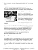
On May 17, 1890, an application for the
Kaweah Post Office at Advance was
granted. In 1910, the current 10-by-12-foot
structure was constructed with a materials
cost of about $15 and was moved several
times to accommodate its patrons. In 1926,
the post office was moved to its present
location on North Fork Drive. On Oct. 24,
The historic Kaweah Post Office.
1948, it was designated a State Historic
Landmark.
Having their sights set on Giant Forest timber that included giant sequoia trees, the
Kaweah colonists inadvertently fueled a conservation movement that led to the
establishment of Sequoia National Park (California's first national park and the
nation's second) in September 1890. In 1892, internal strife and the failure to
procure timber claims contributed to the demise of the Kaweah Colony. Many
members packed up and left, but a few of the original colonists and their
descendants stayed and settled in Three Rivers.
Travel and Tourism
After Congress established Sequoia National Park, Three Rivers began to cater to
an increasing number of visitors to Giant Forest and Mineral King (which was not
added to Sequoia National Park until 1978). In 1892, James Barton deeded the
North Fork road right-of-way to Tulare County for one dollar, and it was extended to
link with the Colony Mill Road, providing public access to the newly created national
park.
In 1894 the Britten brothers built the two-story Three Rivers odge in the vicinity of
This website uses cookies to improve your experience. We'll assume you're ok with this, but you can opt-
out if you wish.
Accept
Read More
11/26/2019
The history of Three Rivers: A place of inspiration - 3R News
In 1899, John Broder and Ralph Hopping>opened Camp Sierra on the North Fork
and guided visitors into the park on horseback. In 1900, they started the first stage
line into Sequoia Park, which traveled to road's end at the old Colony Mill. From
there, travelers would walk or ride horseback remaining six miles to Round Meadow
in Giant Forest to stay at Broder and Hopping's camp.
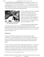
In 1903, the federal government completed a
road extension linking the eight-mile
segment of Colony Mill Road with Giant
Forest. This route remained the main
entrance to Sequoia until the completion of
State Highway 198 in 1923 and, after five
years of construction, the opening of the 18-
mile Generals Highway in 1926.
The Generals Highway in Sequoia National
Park is little changed since 1926.
In 1935, the park-to-park highway opened,
linking Sequoia National Park with General Grant National Park (which was
enlarged and became Kings Canyon National Park in 1940). Also in 1935, the Three
Rivers Airport opened, dedicated as Jefferson Davis Field. The one-runway airport
closed to air traffic in 1970.
Vital Services
In September 1898, Mount Whitney Power and Electric Company began
construction on a flume along the East Fork of the Kaweah River using redwood
lumber from Atwell's Mill near Mineral King and built a hydroelectric power plant
(located near the present-day junction of State Highway 198 and Mineral King
Road).
On June 29, 1899, when the water first surged through Kaweah No. 1, transformed
to energy, and was delivered to Visalia, it was called "an enterprise of mammoth
proportions." On that day, electricity was transmitted a greater distance than had
ever been accomplished before anywhere. Ironically, Three Rivers did not benefit
immediately from this electrical engineering feat, although it was the settlement
closest to the source of the hydroelectric power.
This website uses cookies to improve your experience. We'll assume you're ok with this, but you can opt-
out if you wish
Read More
11/26/2019
The history of Three Rivers: A place of inspiration - 3R News
refrigeration, and irrigate their ranches. In 1905, Kaweah Powerhouse No. 2
(located on present-day Kaweah River Drive) was completed, and in 1913, Kaweah
Powerhouse No. 3 (Ash Mountain) was built. Mount Whitney Power and Electric
Company was acquired by Southern California Edison in 1917. In 1947, the original
redwood flume was replaced with metal siding.
In 1904, the first telephone line was installed in Three Rivers. The "farmer's phone
line" connected Three Rivers residents to each other and to the Valley a decade
later. In 1909, Sequoia Hall was built, which became the community civic center. In
1910, Adam Bahwell donated land to the County of Tulare for the creation of the
Three Rivers Cemetery.
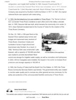
On Dec. 23, 1955, a 100-year flood on the
Kaweah River washed away homes and
bridges and marooned many sections of
Three Rivers. Downtown Visalia and
hundreds of acres of agricultural land
downstream also flooded. As a result, in
1962, Terminus Dam was constructed. Lake
Kaweah, with a capacity of 150,000 acre-feet,
The devastation of the 1955 flood.
was created to provide downstream flood
control and storage for irrigation water supply, as well as recreation and hydropower.
In 2004, 450-ton fusegates were installed, the largest in the world, to increase flood
protection and storage capacity to 185,000 af.
In 1955, the County of Tulare built the South Fork Fire Station. In 1970, the Three
Rivers Community Services District was formed. The government entity was created
to monitor water quality and to oversee any other general services necessary for the
safety and protection of the unincorporated foothills community of Three Rivers.
FILED UNDER: THREE RIVERS HISTORY
About Sarah Elliott
Contact SaraharRiversNews.com
This website uses cookies to improve your experience. We'll assume you're ok with this, but you can opt-
out if vou wish. Accept
Read More
-- History of Three Rivers, CA, Kaweah Colony, Lemon Cove, Woodlake
Page 1 of 4
Home
Advertise
Subscribe
Submit News
Contact Us
About TKC
Search
News and Information of KAWEAH COUNTRY - Three Rivers,
Sequoia and Kings Canyon National Parks, Lemon Cove and Woodlake
Visitor Information:
Kaweah Colony Sequoia and Kings National Parks I Lemon Cove Woodlake
Three Rivers
Sequoia National Park
Kings Canyon National Park
The History of Three Rivers, California
Real Estate
Hotels
A place of inspiration, now and then
Restaurants
Shopping
Attractions
After reading "The History of Three Rivers" below,
Hiking
see "Stories from the Past,"
Local History
and get to know some of those
Travel Information
who have called Three Rivers home
Newspaper:
Weekly News and Features
Weekly Weather
Early Settlement
Calendar of Events
Property Rentals
When Tulare County was created in 1852, its
Columns/ Opinions
boundaries encompassed 24,231 square miles from
Readers Poll
Mariposa County on the north to Los Angeles County
Newspaper Archives
on the south and westward to the Coast Range and
KAWEAH KAM:
east to the Utah Territory. Near the geographical
Live Web Cam of Sequoia
center of these far-flung political boundaries was a
National Park, the High Sierra
remote river canyon inhabited by about 2,000 Indians
and Three Rivers, CA
and containing a wealth of natural beauty.
One of the oldest homes in
Three Rivers
can still be seen on
Yet, for all its scenic wonders, the isolated canyon at
Old Three Rivers Drive,
the site of the
the western base of the southern Sierra Nevada
first permanent settlement
remained virtually unexplored for several more years.
in the community
that included a store, lodge,
The first white settler arrived in 1856. That man, a
and stage stop.
cattleman named Hale Dixon Tharp (1829-1912),
settled on Horse Creek nears its confluence with the Kaweah River.
During the 1860s, other stockmen and ranchers began to locate along the various
Site Map
forks of the Kaweah River. Much of the land being claimed in the area was under the
provisions of the Homestead Act of 1862, which allowed a settler to occupy 160
BOOKMARK
acres, or 320 acres for a man and wife. Early homesteads were located along the
RSS FEED
South, Middle, and North forks of the Kaweah River.
Following the discovery of silver in 1872 and the subsequent creation of the Mineral
King Mining District in 1873, a trail, built by John Meadows (who later founded
Silver City near Mineral King), was extended from the growing foothills community
to link with a stock trail that led from Milk Ranch into the Mineral King valley. In
1879, the Meadows Trail was improved to accommodate prospectors and travelers
who made their way up the East Fork. This wagon road became known as the
Mineral King Road.
In 1879, the name of Three Rivers was suggested by Louisa (Mrs. Lorenzo)
Rockwell, and an application was filed for a post office. The community was SO
http://kaweahcommonwealth.com/threerivershistory.htn
3/22/2010
History of Three Rivers, CA, Kaweah Colony, Lemon Cove, Woodlake
Page 2 of 4
named for the North, South, and Middle forks of the Kaweah River which converged
nearby.
In 1886, the Kaweah Colony was established as a tent camp at Advance on the North
Fork. The utopian socialists began to attract attention, both locally and nationwide,
with the building of a road to access timber claims in the Giant Forest. On May 17,
1890, an application for the Kaweah Post Office at Advance was granted. In 1910,
the current 10-by-12-foot structure was constructed with a materials cost of about
$15 and was moved several times to accommodate its patrons. In 1926, the post
office was moved to its present location on North Fork Drive. On Oct. 24, 1948, it
was designated a State Historic Landmark.
Having their sights set on Giant Forest timber that included giant sequoia trees, the
Kaweah colonists inadvertently fueled a conservation movement that led directly to
the establishment of Sequoia National Park (California's first national park and the
nation's second) in September 1890. In 1892, internal strife and the failure to procure
timber claims led to the demise of the Kaweah Colony. Many members packed up
and left, but a few of the original colonists and their descendants stayed and settled in
Three Rivers. For a comprehensive history of the Kaweah Colony, visit the
publisher's website: www.ravenriverpress.com.
Travel and Tourism
After Congress established Sequoia National Park, Three Rivers began to cater to a
increasing number of visitors to Giant Forest and Mineral King (which was not added
to Sequoia National Park until 1978). In 1892, James Barton deeded the North Fork
road right-of-way to Tulare County for one dollar, and it was extended to link with
the Colony Mill Road, providing public access to the newly created national park. In
1894, the Britten brothers built the two-story Three Rivers Lodge in the vicinity of
the South Fork (later known as Old Three Rivers). In 1897, Noel and Nellie Britten
opened the area's first general merchandise store in that same location. In 1899, John
Broder and Ralph Hopping of Three Rivers opened Camp Sierra on the North Fork
and guided visitors into the park on horseback. In 1900, they started the first stage
line into Sequoia Park, which traveled to road's end at the old Colony Mill. From
there, travelers would walk or ride horseback four miles to Round Meadow in Giant
Forest to stay at Broder and Hopping's camp.
In September 1898, Mount Whitney Power and Electric Company began construction
on a flume along the East Fork of the Kaweah River using redwood lumber from
Atwell's Mill near Mineral King and built a hydroelectric power plant (located near
the present-day junction of State Highway 198 and Mineral King Road). On June 29,
1899, when the water first surged through Kaweah No. 1, transformed to energy, and
was delivered to Visalia, it was called "an enterprise of mammoth proportions." On
that day, electricity was transmitted a greater distance than had ever been
accomplished before anywhere.
Ironically, Three Rivers did not benefit immediately from this electrical engineering
marvel, although it was the settlement closest to the source of the hydroelectric
power. It wasn't until 1926, after a campaign by the Three Rivers Woman's Club, that
community members had the luxury of electricity to light their homes, provide
refrigeration, and irrigate their ranches. In 1905, Kaweah Powerhouse No. 2 (located
on present-day Kaweah River Drive) was completed, and in 1913, Kaweah
Powerhouse No. 3 (Ash Mountain) was built. Mount Whitney Power and Electric
Company was acquired by Southern California Edison in 1917. In 1947, the original
redwood flume was replaced with metal siding.
In 1904, the first telephone line was installed in Three Rivers, The "farmer's phone
line" connected Three Rivers residents to each other and to the Valley a decade later.
In 1909, Sequoia Hall was built, which became the community civic center. In 1910,
http://kaweahcommonwealth.com/threerivershistory.htm
3/22/2010
Mineral King Visitor Center
Page 1 of 4
Welcome to Mineral King
Silver City
Timber Gap
Atwell Mill
9450Ft
(Private community)
6540ft
2387m
6935F+
1993m
21 14m
Sawtpath
Pass
Monarch
Lakes
Cold Springs
A
Pack Station
7830F+
2387m
a
Mosquito
Lakes
Eagle
Lake
Franklin
Lakes
White Chief
Lake
Farewell Gap
Mineral King Valley, an open glacial canyon hemmed in by the peaks of the Great Western Divide, has a
special place in the hearts of many park visitors. Accessible only by a long, slow-going road, the valley is
a place where nature, not man, dominates. This road to this area closes from November 1 to late May.
Road is steep. RVs and trailers strongly discouraged.
Mineral King first gained recognition in the early 1870's when silver was discovered in the valley. Miners
rushed to the area in 1873. The mines never produced, but the Mineral King Road, built by a mining
company in 1879, did open the area to logging, hydro-electric development, tourism and the building of
summer cabins. For many years, the area was a designated game refuge within the national forest.
The valley and surrounding peaks of Mineral King, some 12,600 acres, were transferred from the national
forest to Sequoia National Park by act of Congress in September, 1978. This ended close to 20 years of
controversy over a proposed ski resort development.
What would you like to know about Mineral King?
How do I get there?
What is the weather like?
What facilities are available?
What ranger-guided activities are available?
What can I see on my own?
What hiking trails are in the area?
I am interested in backpacking in the Mineral King area.
Warning, Marmots!
Each spring and early summer, the marmots of Mineral King dine on rare delicacies in
this alpine valley. Their fare includes radiator hoses and car wiring! Like bears, jays and
ground squirrels, marmots have not only become accustomed to visitors, they have
http://www.nps.gov/archive/seki/mkvc.htm
4/10/2010
Mineral King Visitor Center
Page 2 of 4
learned that people are a source of food.
In the parking areas some marmots feast on car hoses and wires. They can actually disable a vehicle. On
several occasions, marmots have not escaped the engine compartment quickly enough and unsuspecting
drivers have given them rides to other parts of the parks; several have ridden as far as southern
California!
The whole thing sounds ridiculous, but it's true. If you visit Mineral King, especially during the spring,
check under you hood before driving away. Let the rangers know whether or not your vehicle has been
damaged. And don't forget, marmots also love to feast on boots, backpacks, and other equipment.
Points of Interest in the Mineral King area
Atwell (Skinner) Grove: This sequoia grove was partially logged in the 1890's. It continues onto
Paradise Ridge, giving it the highest elevation of any sequoia grove. The Paradise Peak trail explores the
upper part of the grove.
-
Atwell Mill: In a clearing across from the Atwell Mill Ranger Residence stands a large
steam engine, one of the last signs of the mill that was used for cutting timber from the
surrounding forests. Kaweah colonists leased the site after their Giant Forest claims were
disallowed. Many young sequoias have grown up around the mill site in the 75-100 years since logging
ceased.
Mineral King Valley: This unique, glacially sculpted valley exhibits a variety of rock
types, including marble, shale, schist and granite. Vegetation includes sagebrush,
pinemat manzanita, and a great variety of wildflowers that prosper in the open sun.
Cold Springs Nature Trail: The exhibits along this easy one-mile trail illustrate the natural history of
the Mineral King Valley. The trail begins in Cold Springs Campground across from the ranger station.
Sawtooth Peak (12,343') is the most prominent peak in the Mineral King area. Upper portions of the
peak are granite and shaped by glaciers. As with other peaks surrounding the valley, Sawtooth resembles
the Rocky Mountains more than the Sierras due to the predominance of metamorphic rocks in the
Mineral King area.
Mineral
Main
King
Visitor Center
http://www.nps.gov/archive/seki/mkvc.htm
4/10/2010
Mineral King Visitor Center
Page 3 of 4
Hikes in Mineral King
The elevation at the floor of the Mineral King Valley is 7500' (2286 meters). Hiking at this altitude is
strenuous. Gauge your hiking to the least fit member of your party. During the early summer, mosquitoes
can be a particular nuisance. As in all areas of the park, it is best to carry water, as the purity of the lakes
and streams along the trails cannot be guaranteed. The hikes described below are suitable for day trips,
but backcountry permits are also available for many of the areas.
Please be aware that pets are not allowed on any trails in Sequoia and Kings Canyon National Parks. In
developed areas, pets must be kept on a leash at all times.
Monarch Lakes: Upper and Lower Monarch Lakes lie at the foot of Sawtooth Peak, at the
end of a 4.2 mile (one-way) hike. This is one of the easier hikes in the Mineral King area, but
since the trail follows a west-facing slope, it is best to get an early start. The trail passes
through meadows, red fir forest, and the avalanche-scoured Chihuahua Bowl, a basin named
by hopeful miners for an area of rich mines in Mexico. It then rounds a shoulder and gives views north
and east across the Monarch Creek canyon to Timber Gap, the Great Western Divide and Sawtooth Pass.
Beyond the lakes, the trail climbs 1200' in 1.3 miles (366 meters in 2 km) to Sawtooth Pass, a strenuous
hike, but one that provides one of the grandest views in the southern Sierras. The footing on this portion
of the trail is very loose. Please use caution.
Crystal Lake: The trail to Crystal Lake (4.9 miles one-way) branches off of the Monarch Lakes Trail at
Chihuahua Bowl, passing the remnants of the old Chihuahua Mine near the south rim. It then climbs
steeply, providing panoramic views of the southern part of the Mineral King Valley, including White
Chief Peak and Farewell Gap. The trail, and the small dam on Crystal Lake were built by the Mt.
Whitney Power Company between 1903 and 1905. The Southern California Edison Co. still operates the
facility. There is no maintained trail beyond Crystal Lake.
Timber Gap: This trail follows an old mining route along Monarch Creek before branching off from the
trail to Monarch and Crystal Lakes. The open slopes surrounding the Mineral King Valley are kept free
of trees by avalanches; Timber Gap itself is protected from avalanches, and is covered with red fir which
the miners in the 1800's used for fuel and to shore up their mine shafts. From Timber Gap, you can see
north to the Middle Fork of the Kaweah River and across to Alta Peak. The hike to Timber Gap is 2 miles
one-way.
Franklin Lakes: This trail provides many views of the rainbow-colored metamorphic rocks
that attracted miners to this area in the 1870's, in the hopes of finding silver. Although the 5.4
mile one-way hike can be done as a day trip, many backpackers make these lakes their first
stop on their way over Franklin Pass to Rattlesnake Canyon, the Kern Canyon and Mt.
Whitney.
White Chief Trail: The White Chief mine, claimed by James Crabtree in 1873, made
Mineral King a household name among miners of that time. Crabtree's ruined cabin,
located near the meadow beyond the junction with the Eagle/Mosquito Lakes Trail, is
http://www.nps.gov/archive/seki/mkvc.htm
4/10/2010
Mineral King Visitor Center
Page 4 of 4
perhaps the oldest remaining structure in the Mineral King area. The 2.9 mile one-way trail to the White
Chief Bowl is a steep but scenic hike up the west side of the Mineral King Valley.
Eagle and Mosquito Lakes: The route to both of these lakes follows the same trail for
the first 2 miles, ascending steadily up the west side of the Mineral King Valley. After
it
reaches the lower rim of Eagle Basin, the trails split. The left-hand trail goes to Eagle Lake, a glacially
carved tarn 3.4 miles (one way) from the trailhead. The right-hand trail ends at Mosquito Lake #1, 3.6
miles (one way) from the trailhead, but hikers and fishermen often continue up the drainage to the upper
lakes.
Mineral
Main
National
King
VisitorCenter
Park Service
http://www.nps.gov/seki/mkvc.htm
Last update: December 11, 2002
http://www.nps.gov/archive/seki/mkvc.htm
4/10/2010
Lodgepole/Giant Forest Visitor Center
Page 1 of 4
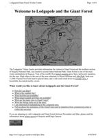
Welcome to Lodgepole and the Giant Forest
Lodgepole
Visitor Center
6720ff
Lodgepole
Wuksachi
2048m
Hálstead
Meadow
Village
Wulverton
General
Panther
Sherman Tree
Gap
BigTrees
Trail
Giant Forest Museuri
Tharps
Log
++
Auto
Crescent Meadow
Log
0.5 Km
Tunnel Log
Morn Rock
0.51
The Lodgepole Visitor Center provides information for visitors to Giant Forest and the northern section
of Sequoia National Park, our country's second oldest National Park. Giant Forest is one of the main
visitor destinations in Sequoia. Four of the world's five largest sequoias grow here, and scenic meadows
dot the area. High ridges to the east of the area culminate in Mount Silliman and Alta Peak, both over
11,000'. Popular foot trails lead to glacial lakes, and a side road winds down to Crystal Cave, a
beautifully decorated marble cavern.
What would you like to know about Lodgepole and the Giant Forest?
How do I get there?
What is the weather like?
What facilities are available?
What ranger-guided activities are available?
What are the major sites in Giant Forest?
What day-hiking trails are in the area?
I am interested in backpacking in the Lodgepole area.
Tell me about the restoration of the Giant Forest and its transition from commercial center to
visitor day-use area.
If you are planning to visit Lodgepole and Giant Forest between November and May, please read the
information about winter access to Sequoia and Kings Canyon.
Main
Visitor Center
http://www.nps.gov/archive/seki/lpvc.htm
4/10/2010
Lodgepole/Giant Forest Visitor Center
Page 2 of 4
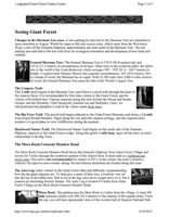
Seeing Giant Forest
Changes in the Sherman Tree area: A new parking lot and trail to the Sherman Tree are scheduled to
open sometime in August. Watch for signs to this new access route, which starts from the Wolverton
Road, a turn off the Generals Highway approximately one mile north of the Sherman Tree. The old
parking area and trail to the tree will close for ecological restoration and development of new trails and
exhibits.
General Sherman Tree: The General Sherman Tree is 274.9' (83.8 meters) tall, and
102.6 (31.3 meters) in circumference at its base. Other trees in the world are taller: the tallest
tree in the world is the Coast Redwood, which averages 300' 350' (91.4 106.7 meters) in
height. A cypress near Oaxaca, Mexico has a greater circumference, 162' (49.4 meters). But
in volume of wood, the Sherman has no equal. With 52,500 cubic feet (1486.6 cubic meters)
of wood, the General Sherman Tree earns the title of the World's Largest Tree.
The Congress Trail:
This 2 mile stroll begins at the Sherman Tree, and follows a paved trail through the heart of
the sequoia forest. It is recommended for first-time visitors to the Giant Forest, and for
visitors with limited time. Famous sequoias along this trail include the House and Senate
Groups, and the President, Chief Sequoyah, General Lee and McKinley Trees. An
informational trail pamphlet is sold at the visitor center book store.
The Big Trees Trail: This paved trail begins adjacent to the Giant Forest Museum, and forms a 1.2-mile
loop around Round Meadow. Signs along the way describe sequoia ecology, and this sequoia-lined
meadow is a good place to view wildflowers during the summer.
Hazelwood Nature Trail: The Hazelwood Nature Trail begins on the south side of the Generals
Highway, adjacent to the Giant Forest Lodge. Along this gentle 1 mile loop, signs tell the story of man's
relationship to the Big Trees.
The Moro Rock-Crescent Meadow Road
The Moro Rock-Crescent Meadow Road leaves the General's Highway from Giant Forest Village and
travels for 3 miles through the southwest portion of the Giant Forest. It dead-ends at a trailhead and
picnic area. This road is not recommended for trailers or RV's. In the winter, the road is closed to
vehicles, but open to cross-country skiing. Several famous attractions are located along this road.
The Auto Log: Early visitors to the Giant Forest often had difficulty comprehending
how big the giant sequoias are. To help give a sense of their size, a roadway was cut
into the top of this fallen tree. Due to rot in the log, cars can no longer drive on it, but it
remains an interesting historic feature. The Auto Log is located 0.9 miles from Giant
Forest Village on the Moro Rock-Crescent Meadow Road.
Moro Rock: The parking area for Moro Rock is 2 miles from the village. A steep 1/4
mile staircase climbs over 300' (91.4 meters) to the summit of this granite dome. From
the top, you will have spectacular views of the western half of Sequoia National Park
http://www.nps.gov/archive/seki/lpvc.htm
4/10/2010
Lodgepole/Giant Forest Visitor Center
Page 3 of 4
and the Great Western Divide. This chain of mountains runs north/south through the
center of Sequoia National Park, "dividing" the watersheds of the Kaweah River to the west and the Kern
River to the east. Also on the eastern side of the divide is Mt. Whitney, the tallest mountain in the lower
48 states. Unfortunately, because many of the snowcapped peaks in the Great Western Divide reach
altitudes of 12,000' (3657 meters) or higher, it is impossible to see over them to view Mt. Whitney from
Moro Rock. The summit of Alta Peak, a strenuous 7-mile hike from the Wolverton picnic area, is the
closest place from which to see Mt. Whitney.
The Parker Group: The Parker Group is considered one of the finest clusters of sequoias
which can be reached by automobile. It is 2.6 miles from the Giant Forest Village.
The Tunnel Log: Sequoia and Kings Canyon have never had a drive-through tree. The
Wawona Tunnel Tree, the famous "tree you can drive through", grew in the Mariposa
Grove of Yosemite National Park, 100 air-miles north of Sequoia and Kings Canyon. It
fell over during the severe winter of 1968-69. Visitors to Sequoia National Park can
drive through a fallen sequoia, however. In December 1937, an unnamed sequoia
275' (83.8 meters) high and 21' (6.4 meters) in diameter fell across the Crescent Meadow Road as a result
of "natural causes". The following summer, a Civilian Conservation Corps crew cut a tunnel through the
tree. The tunnel is 8' (2.4 meters) high and 17' (5.2 2 meters) wide, and there is a bypass for taller vehicles.
Crescent Meadow: The Crescent Meadow Road ends at a parking and trailhead area less
than 100 yards (91.4 meters) from the edge of Crescent Meadow. A popular hike from
Crescent Meadow is the 1-mile stroll to Tharp's Log, a fallen sequoia that provided a rustic
summer home for the Giant Forest's first Caucasian resident, Hale Tharp. Another easy 1 1/2
mile trail circles the meadow, which is an excellent place to view wildflowers in the summer.
Some lucky visitors to this and other meadows in the park may also have an opportunity to
see a bear. Because Crescent Meadow is a fragile environment, please stay on designated trails and walk
only on fallen logs for access into the meadows.
Ladgepole/
Main
Giant Forest
Visitor Center
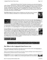
Day Hikes in the Lodgepole/Giant Forest Area
More complete maps and descriptions of the trails in this area are sold at Visitor Center Book Stores at
Lodgepole, Ash Mountain, Grant Grove and Cedar Grove.
Please be aware that pets are not allowed on any trails in Sequoia and Kings Canyon National Parks. In
developed areas, pets must be kept on a leash at all times.
Tokopah Falls: The trail to Tokopah Falls starts just beyond the Log Bridge in Lodgepole
Campground. It is an easy 1.7 mile (one way) walk along the Marble Fork of the Kaweah
http://www.nps.gov/archive/seki/lpvc.htm
4/10/2010
Lodgepole/Giant Forest Visitor Center
Page 4 of 4
River to the impressive granite cliffs and waterfall of Tokopah Canyon. Tokopah Falls is
1200' (365.8 meters) high, and is most impressive in early summer, when the run-off from the melting
snowpack in the Pear Lake region upstream is at its peak.
Little Baldy Trail: The trail to the summit of Little Baldy begins 11 miles north of the Giant Forest
Village on the Generals Highway. This trail is 1.7 miles one way, and climbs 700' (213.3 meters). At an
elevation of 8044' (2451.8 meters) the granite dome of Little Baldy is an excellent location from which to
study the terrain of the Giant Forest Region.
The Lakes Trail: The popular Lakes Trail begins at Wolverton picnic area and ascends
steeply to a chain of glacial lakes. Heather Lake, the first lake on the trail, is 4 miles from
Wolverton. Camping is not permitted at Heather Lake, but backpacking permits are available
for Emerald and Pear Lakes, 5.7 miles and 6.7 miles respectively from the trailhead.
Alta Peak Trail: "Alta" means "high" in Spanish, and Alta Peak provides some of the
best views and high-country scenery within day-hiking distance of the
Lodgepole/Wolverton area. On a clear day, you can even see across the Great Western
Divide to Mt. Whitney from the summit of Alta Peak (11,204'/3415 meters). However,
the steep grades and high altitudes along this trail make it one of the most strenuous in
the western half of Sequoia National Park. Don't try this hike unless you are in good physical condition.
The 13.8 mile round-trip hike to Alta Peak begins at the Wolverton picnic area. Backcountry permits are
also available for this trail.
Ludgepile/
Main
National
Giant Forest
Visitor Center
Park Service
http://www.nps.gov/seki/lpvc.htm
Last update: August 1, 2005
http://www.nps.gov/archive/seki/lpvc.htm
4/10/2010
UNH LIBRARY
3 4600 00013965 6
John Muir Summering in the Sierra
Edited by
Robert Engberg
University of Wisconsin Press
[1984]
due
11/12
2.
CONTENTS
Illustrations
ix
Acknowledgments
xi
Preface
xiii
Introduction: Wilderness Journalism
3
Part One: Mount Shasta and the Lava Beds
17
Salmon-Breeding
20
Shasta in Winter
30
Shasta Game
39
Modoc Memories
52
Shasta Bees
59 .
Part Two: Home in Yosemite
65
The Summer Flood of Tourists
68
A Winter Storm in June
74
In Sierra Forests
79
Part Three: To Kings Canyon and
Mount Whitney's Summit
91
A New Yosemite - The King's River Valley
92
Ascent of Mount Whitney
104
From Fort Independence
113
Part Four: Return to the Sequoia Groves
121
The Royal Sequoia
123
The Giant Forests of the Kaweah
131
Tulare Levels
139
South Dome
143
Selected Sources and List of Readings
153
Index
157
vii
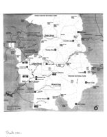
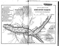
Mt Pinchot
KINGS CANYON NATIONAL PARK
4113m
Pinchot Pass
13495ft
3673m
1205Oft
Obelisk
2957m
9700ft
Kennedy Pass
3322m
10900ft
Granite Pass
3253m
10673ff
Converse
180
Road open summer only
Rae Lakes
Basin Grove
Mist Falls
ONION VALLEY
Boyden
South Fork
Cedar Grove
Independence
Cave
Kings River
Glen Pass
See other side for detail
3651m
Hume Lake
11978ft
Kearsarge Pass
3604m
SEQUOIA NATIONAL FOREST
11823ft
To Lone
Lookout Peak
Grant Grove
Charlotte Lake
Pine
2600m
See other side for detail
8531ft
resno
Avalanche Pass
John
80
3060m
Muir
1004Oft
Trail
Generals
INYO
Highway
NATIONAL
Stony Creek facilities
Roaring River
a
Redwood
include food, lodging, gas,
FOREST
Mountain
grocery store, and stable.
Foresters Pass
Grove
4011m
13180ft
Big Baldy
Stony Creek
JO Pass
2502m
2868m
8209ft
9410ft
Twin
Lost Grove
Lakes
Silliman Pass
3048m
10000ft
245
Dorst
R
Tokopah Falls
a
Giant Forest
Colby Pass
Pear Lake
Elizabeth Pass
3658m
To Lone
See other side for detail
3475m
12000ft
Pine
11400ft
Crystal Cave
John
High
Mt Whitney
Area open summer only
Muir
4418m
Sierra
Trail
14495ft
Whitney Portal
Trail
2550m
8367ft
Mt Muir
Bearpaw Meadow
Crabtree
TO
4272m
Trail Crest
14015ft
4170m
A
Potwisha
to
13680ft
Middle
SEQUOIA NATIONAL PARK
A
Buckeye Flat
Hospital Rock
Generals
Ash Mountain
High
Highway
Sierra
Park Headquarters
Trail
Rock Creek
Hammond
Mineral King
See below for detail
Siberian Pass
3338m
10950ft
Three Rivers
Road open
summeronly
East
Fork
Lake
Kaweah
Lookout Point
Franklin Pass
198
3597m
11800ft
Farewell Gap
3227m
10587ff
Hockett Meadow
e
Visalia and
tel Route 99
Fork Kaweah
Kern Canyon
South Fork
Coyote Pass
0
1
2
3
4
5 kilometers
3097m
North
A to
10160ft
0
1
2
3
4
5miles
T
The History of
Sequoia National Park, 1876-1926
Part II: The Problems of the Early Years
BY DOUGLAS H. STRONG
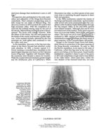
The Congressional legislation of September 25 and October 1,
1890, which created and first enlarged Sequoia National Park,
did not succeed in protecting the Sierra watershed as those who
initiated the movement for a vast forest reserve had hoped it
would. Only seven townships had been set aside for the Park, and
even this small area remained inadequately protected and was
interspersed with privately owned land. The movement begun
by George W. Stewart and others was to gain new support, how-
ever, and to culminate in the creation of the Sierra Forest Reserve
in 1893. It was from land in this reserve that Sequoia National
Park was enlarged in 1926 to its present size.
Although the first comprehensive Congressional bill provid-
ing for the reservation and protection of public forest lands was
introduced in 1871, no law was passed for the creation of forest
reserves until March 3, 1891, when Secretary of the Interior,
John Noble, managed to slip a clause into an act repealing the
timber-culture laws. This clause, which came to be known as the
"Forest Reserve Act," gave the President authority to set apart and
reserve public timberlands by presidential proclamation.1)
Agitation for a large forest reservation in the Sierra Nevada
east of Sequoia National Park, which had begun in 1889, con-
tinued after the passage of the Forest Reserve Act. The distinction
between a forest reserve and a national park was not yet clearly
defined, but this made no difference. The primary intention was
to protect the Sierra watershed by whatever means possible, In
April, 1891, Stewart stated in the Visalia Delta that the act of
October 1 should have included the crest of the Sierra and the
headwaters of all the rivers therein. Such a reservation would
have prevented the continuing deforestation of the area by fires,
cattle, and sheep. Stewart realized also that immediate action
[265]
Southern Calet.Quar. 48, 3 3 (1966):265-287.
This content downloaded from
137.49.125.110 on Thu, 13 Aug 2020 14:46:10 UTC
All use subject to https://about.jstor.org/terms
The Historical Society of Southern California
was needed if the acquisition of land rights in the high moun-
tains was to be forestalled.
John Muir and Robert Underwood Johnson, editor of the
Century Magazine, joined in the agitation for a large forest reser-
vation in the southern Sierra. In May, 1891, Muir recommended
to Johnson that a large park be established which would include
the headwaters of the Kings, Kern, and Kaweah rivers.2 Johnson
in turn acquainted Noble with Muir's ideas.3 Noble requested
additional information from Muir in September and notified
Johnson that the matter was being carefully considered. In
November Johnson published an article on Kings Canyon by
Muir which called for a great national park.5 Noble prepared to
consult with President Benjamin Harrison on the matter. Mean-
while all of the timberland in the area under consideration for a
forest reserve was withdrawn from sale or other disposal by the
Commissioner of the General Land Office.6 Yet despite all this
activity, a final decision as to boundaries had to await the out-
come of an investigation of the withdrawn townships by Special
Agent B. F. Allen.
Allen received his instructions in October, pursued his investi-
gations in the Sierra until he was driven out by snow in Decem-
ber, and returned in May, 1892, to complete the assignment.
With the aid of suggestions by John Muir and the directors of
the newly created Sierra Club, he wrote a report advocating the
formation of a large park. 8 Upon returning to Washington, Allen
received orders from Noble to work nights if necessary to deter-
mine the boundaries so that President Harrison could establish
the reserve before he left office. In February, 1893, Noble an-
nounced to Johnson that Allen's reservation included nearly
6,000 square miles, or roughly four million acres. 9 Allen found
general support for the proposed reserve among all Californians
except the sheepherders and lumbermen who had something to
lose. There appeared to be no mining activity and only a few
prospectors. On this basis Allen stated,
The conclusion of the whole matter is: That if the reservation is estab-
lished, the benefit to California will be beyond estimate; because there-
by, the sources of water supply will be guarded and preserved; the
scenic features will attract tourists from all over the world and a great
National Park established easily accessible to all her people. 10
266]
This content downloaded from
137.49.125.110 on Thu, 13 Aug 2020 14:46:10 UTC
All use subject to https://about.jstor.org/terms
The History of Sequoia National Park, 1876-1926
(The proclamation for the reserve was ready by February 10
and received the President's signature on February 14, 1893.
Thus the Sierra Forest Reserve was created and the upper water-
shed of the San Joaquin Valley set aside. Although it was not the
first forest reserve established under the act of March 3, 1891, it
was one of the first that had been petitioned for successfully.11/
(Regrettably, the creation of the Sierra Forest Reserve did not
provide automatically for the protection of the watersheds within
its boundaries. In the Forest Reserve Act of 1891 there was no
provision for the administration necessary to protect the land set
aside. Lumbermen and sheepmen continued to treat it as un-
reserved public domain Logging was minimal due to the inac-
cessibility of the timber, but sheepherders, with nowhere else to
go, still used their traditional grazing grounds.
In 1894, a special agent of the General Land Office, T.P. Lupkin,
reported that an agent had been sent to the new San Gabriel
Forest Reserve in southern California to stop the depredations of
the sheep. After a few days the agent returned to Washington. 12
After all, what could one man do in millions of acres against
seasoned sheepherders who knew the terrain and remained pri-
marily in remote areas? Even in the rare case when an indict-
ment was obtained for some destructive deed, juries normally
freed the culprits.
As late as 1896, Professor William Dudley, who had explored
in Tulare County on both sides of the Great Western Divide in the
southern half of the Sierra Forest Reserve, reported that there
was no protection against fire, timber thieves, and sheepherd-
ers. 14 Finally, in the Sundry Civil Appropriations Act of June 4,
1897, Congress provided for a first step in an administrative pro-
gram for the protection of the forest reserves But although there
was a Division of Forestry within the Department of Agriculture,
it was the General Land Office of the Interior Department that
retained jurisdiction,
At roughly the same time, both John Muir and Professor Dud-
ley called attention to the effective protection provided by troops
in Sequoia National Park. Muir stated, "In the fog of tariff, silver,
and annexation policies, it [the Sierra Forest Reserve] is left
wholly unguarded, though the management of the adjacent na-
tional parks by a few soldiers shows how well and how easily it
[ 267 ]
This content downloaded from
137.49.125.110 on Thu, 13 Aug 2020 14:46:10 UTC
All use subject to https://about.jstor.org/terms
The Historical Society of Southern California
Northern Boundary of Processed
T.12 S. MITD.MER.
DOME
TEHIPITEE
Middl,
Fork Kings A
VALLEY
R.25 E
R.26E
*R.27E.
R 28 a
R.29E
R 30 E
R.3LF.
C.B
KINGS,
MIKEARSARGE
V.CAMEN
T.13 S
B.C.
F.B
FRESNO
00
MYBRIWER
8.32E
TULARE
TYNDALL
c d
T.14.5
RCASH
MTWILLYAMSOW
MILESTONE
Camp Badger
S4N.K
T.15 S.
15000
T.10 S
CLAFF
CHOW
NERS
@800
5
Tautruss
ThreePavers
ALWANDEVER
Kaweah
1000
T.18 S
VISALIA
ASH
Exeter
D
T.195.
T.R.
FORESTS a GROVES
B.C. Boulder Creek Forest
While
Lindsay
C.B. Converse Basin
9Cramer
###
Dillon's
T.20 S
P.G
F Fleitz
F.V.
F.V. Freeman Valley
F.B. Fresho Big Trees
and
Giant
River
T.21 S.
P.M
I.R. Indian Reservation
Portervilled
K Kessing Groves
Tipton
K.
M.G. Mammoth Grow
IDIAN
M.K. Mineral King
RESERVATION
N.X. North Kawesh
MAP OF THE
PG Pixleys Grove
SEQUOIA NATIONAL PARK
P.M Putnem Mill
R.C. Redwood Canon
AND
S.C. Salt Creek
PROPOSED ADDITION.
2.3.1
S.K. South Kewesh
FRESHO a TOLARE CO*
6
T.R. Tule River
CENTRAL CALIFORNIA
Sequoia Forests claimed,or
SCALE OF MILES
o
10
18
20
T.245.
owned,by Private Parties
Sequoia Forests owned by
TULARE CO.
the Government
Onizon NY
KERN CO
John Muir's map of the Sequoia National Park and proposed additions as
published in Century Magazine, XLIII (November 1891), on page 78.
[ 268 ]
This content downloaded from
137.49.125.110 on Thu, 13 Aug 2020 14:46:10 UTC
All use subject to https://about.jstor.org/terms
The History of Sequoia National Park, 1876-1926
can be preserved.'1s Professor Dudley noted the degree to which
the undergrowth in the mountain forests had disappeared since
sheepherders had brought in their sheep. Valley ranchers re-
garded this as more destructive to their summer water supply
than the cutting of timber. Dudley remarked in particular about
the contrast between the trampled meadows of the Forest Reserve
and the protected meadows of the National Park.
As a matter of fact, protection for the Park itself was still far
from satisfactory, in spite of the fact that the act of September 25,
1890, had in this case given the Secretary of the Interior authority
to provide for it. Secretary Noble had decided that a cavalry
guard should be placed in both Yosemite and Sequoia National
parks, and that the General Grant Grove should be combined
with Sequoia for administrative purposes. 16 He waited for Special
Agent Andrew Cauldwell's inspection report and then imple-
mented his decision by persuading the War Department to furnish
troops. For the next twenty-two years, protection in the Park was
provided by the military,
On June 8, 1891, the first troops arrived at Mineral King, just
south of the Park, and established their camp. It was the only
place accessible where so many men and horses could be accom-
modated. 17 The officer in charge, Captain J. H. Dorst, eventually
received the first set of rules and regulations for the Park, which
had been signed by Noble in October, 1890. 18 The regulations sup-
plemented the general statements contained in the legislation of
September 25 and October 1. They authorized the Superintendent
to remove any trespassers from the Park, but not to make arrests. 19
Except for a confrontation with Kaweah colonists, Dorst had
little difficulty. Very few sheep and cattle were in the Park, al-
though thousands were nearby. A few settlers lived within the
boundaries of the Park, but most of them were legal occupants of
privately owned land. Outside of the Park at Mineral King,
which was a favorite vacation area, over 300 people were camped.
Many parts of the Park were inaccessible, however, and thus
could not be patrolled by men on horseback. In fact, the normal
route between the southern and northern parts of the Park was
by way of the North Fork of the Kaweah River and the Kaweah
Colony sawmill outside of the Park. Although the troops traveled
about 7,000 miles in patrolling the Park during the first year,
[269]
This content downloaded from
137.49.125.110 on Thu, 13 Aug 2020 14:46:10 UTC
All use subject to https://about.jstor.org/terms
The Historical Society of Southern California
Courtesy, Francis P. Farquhar
Walter Fry, the first civilian superintendent of
Sequoia National Park.
many areas remained almost unknown. 20 Hunters killed the
game animals, particularly deer, as they were forced out of the
Park by winter snows. When the troops withdrew from the Park
for the winter, after October 1, no protection at all could be given
the animals. Nevertheless, the very presence of troops in the area
prevented serious depredation.
During the second summer, Dorst reported sheep in both the
northeast and southeast corners of the Park. Probably they had
been there undetected the summer before. The sheepherders
would drive their sheep just across the boundary line, and would
[ 270 ]
This content downloaded from
137.49.125.110 on Thu, 13 Aug 2020 14:46:10 UTC
All use subject to https://about.jstor.org/terms
The History of Sequoia National Park, 1876-1926
then claim ignorance of their error. Frequently the herders would
change places so that the soldiers on patrol would believe that
a
different flock had entered the Park unintentionally. Since the
boundaries were not marked or even accurately surveyed, there
was legitimate excuse for errors.
Increasingly, cattle also became a problem as stockmen real-
ized that the Park Superintendent had no power to make arrests.
Herders placed salt in accessible places in the Park so that cattle
would return after being driven out by troops. Cattle that were
allowed to be driven across the Park for summer grazing beyond
the eastern boundary were also a problem. Herders frequently
turned the cattle loose or allowed them to graze slowly on the
drive to and from the valley. On one occasion soldiers found 150
cattle in the Giant Forest. Although they belonged to Hale and
Nort Tharp who owned land in the Giant Forest, the stock had
not been restricted to the Tharp land.
As a result of all these problems, Dorst requested that the boun-
daries be properly surveyed and marked, and that penalties be
levied for all infractions. Mere expulsion from the Park across
the nearest boundary did not deter trespassers from repeated
illegal entries. There were in fact more stock in the Park in 1892
than there had been the year before.
In the absence of adequate sanctions for infractions of the
rules, the troops devised their own penalties. Although not strictly
legal, these were believed to be in the spirit of the law. Dorst
claimed that neither sheepmen nor cattlemen acted in good
faith. In retaliation the troops now drove trespassing cattle far
to the north into the rugged Kings River country where many
were lost or could be found only with great effort and expense to
their owners. This effectively ended cattle trespass, but sheep-
herders continued to risk entry into Park lands despite the danger
of having their herds scattered in all directions/Frequently the
sheep were driven across one boundary while the sheepherder
was being expelled at a point far distant from his flock. There
simply were not enough men to protect the Park from all the
sheep and large numbers continued to come to the most northern
and southeastern regions.
Before the creation of the Sierra Forest Reserve in 1893, Dorst
estimated that there were half a million sheep grazing in the
[ 271 ]
This content downloaded from
137.49.125.110 on Thu, 13 Aug 2020 14:46:10 UTC
All use subject to https://about.jstor.org/terms
The Historical Society of Southern California
MAP OF
GIANT FOREST - SEQUOIA NATIONAL PARK
SHOWING
RELATION OF MARTIN TRACT To LANDS ALREADY PRESENTED to THE UNITED STATES
26
29
28
MARTIN
GENERAL SHERMAN TREE
MARBLE
35
36
32
33
TRACT
(HOLD
WORK
options
Cirole
$
$
Round
Measow
1
T
Log
2
,
4
F
R
E
S
T
More
Lands
MIS
t.
united
Courtesy, Tulare County Free Library, Visalia
Purchase of private lands in the Giant Forest acquired in January, 1921.
Kings and Kern canyons. It is not surprising, therefore, that he
was unable to visit either area because of lack of feed for his ani-
mals, nor is it any wonder that sheepherders continued to try to
use the mountain pastures upon which they had depended for
so many years.
In 1894, the new Acting Superintendent, Captain James
Parker, managed to make a personal trip to the Kern River coun-
try where he observed the desolation and erosion caused by the
sheep. He posted a hundred notices sent him by the Secretary of
the Interior to warn trespassers to stay off the newly created
Forest Reserve, but they were torn down immediately. Local
[ 272 ]
This content downloaded from
137.49.125.110 on Thu, 13 Aug 2020 14:46:10 UTC
All use subject to https://about.jstor.org/terms
The History of Sequoia National Park, 1876-1926
cattlemen, who used the same region, opposed the sheepherders
and had the general sympathy of the local community The cattle
were thought to do little damage. Parker recommended that they
be permitted to graze on the Reserve but that the sheep be totally
excluded.
Responding to pressure, the General Land Office Commissioner
ruled on June 30, 1897, that the pasturing of livestock, except for
sheep, would not be interfered with as long as it was neither in-
jurious to the forest nor to the rights of others. 23 But one inspector
with only four assistants had to keep track of ten million acres, an
impossible task. The following year, the Commissioner permitted
sheep to graze on private lands within the California reserves if
they were guided to and from the prescribed areas. Since the
guide often cared little where the sheep grazed, this ruling failed
to improve the situation materially. Even when these earliest
forest officials caught trespassers, they had neither support from
Washington nor local sympathy if a local man was involved.
Although the Park remained relatively free of stock, many
sheepherders regarded it as a source of excellent pasturage in the
Indian summer after the troops had left. In 1894, Captain Parker
requested that a guardian remain in the Park for the winter, but
it was several years before anything came of his proposal. ²*
The value of the military guard, even though it lacked ade-
quate legal support, was illustrated graphically in 1898 when
the regular cavalry was withdrawn during the Spanish-Ameri-
can War. A civilian, George Langenberg, received temporary
appointment to take charge, but despite the assistance of six
rangers, he could do little. 25 An estimated 200,000 sheep roamed
unchecked through the Park, fire broke out in the Giant Forest,
and hunters passed wherever they pleased. Benner X. Smith
with a platoon of Utah Volunteers finally arrived late in the year,
and by 1901 the Superintendent reported that to all intents and
purposes grazing had ended. Sheepherders no longer drove their
sheep into the Park, and cattlemen entered only with permission
and under strict supervision.
Although the Park was now relatively well guarded in the
summer, there continued to be no laws under which offenders
could be punished. Although laws had been passed to protect
government property, in the opinion of the various acting super-
[ 273 ]
This content downloaded from
137.49.125.110 on Thu, 13 Aug 2020 14:46:10 UTC
All use subject to https://about.jstor.org/terms
The Historical Society of Southern California
intendents, they were ineffective so far as Sequoia National
Park was concerned. 27 The act of July 7, 1898,28 28 provided that
anyone convicted of a crime committed on United States prop-
erty, for which punishment was not provided under any law of
the United States, should receive the same punishment as pro-
vided by the state law after conviction in a Circuit or District
Court of the United States in the district in which the offense was
committed. 29 This act made no appreciable difference in the
situation, however, since the State Legislature of California
looked to the federal government to provide the necessary legisla-
tion to protect natural resources under federal control. Although
both the state and federal governments had legal jurisdiction
over lands within the Park boundaries, neither had provided
effective enforceable laws.
By an act of February 6, 1905, all persons employed in the
national parks and forest reserves were authorized to make ar-
rests. The person arrested could then be taken for trial before the
nearest United States Commissioner within whose jurisdiction
the crime was committed. Sequoia National Park had no com-
missioner, however! The legal machinery had been authorized,
but no means had been provided for its application to the Park.
In fact, the only recourse open to Park officials was still simple
ejection of wrongdoers from the Park and confiscation of their
property. Under the rules and regulations issued in 1902, and
again in 1907 and 1913, eviction remained the sole punishment.
Inevitably it proved to be an inadequate deterrent to hunters and
others who harmed Park property.
It was not until 1920 that the situation was finally rectified.
By the act of June 2, 1920, Congress accepted the cession by the
State of California of exclusive jurisdiction of the lands embraced
within Sequoia, General Grant, and Yosemite National Parks.
To remove the confusion resulting from the failure of both the
state and federal governments to provide effective, enforceable
laws pertaining to the Park, its superintendents had requested
such a cession for years. A commissioner was now authorized for
Sequoia and General Grant parks who could issue warrants for
arrest, try those arrested, and impose fines or imprisonment.
Effective means had at last been provided to deter those who re-
peatedly ignored Park rules.
[274]
This content downloaded from
137.49.125.110 on Thu, 13 Aug 2020 14:46:10 UTC
All use subject to https://about.jstor.org/terms
The History of Sequoia National Park, 1876-1926
There were other serious problems to be dealt with, however.
Transportation and communication were not much better by the
turn of the century than they had been when the Park and Re-
serve were established. Although the inaccessibility of the Park
meant that few tourists could reach it, and that the danger of
fire and defacement of the Big Trees was thus at least signifi-
cantly reduced, roads were badly needed. The Kaweah Colony
road, which had approached to within nine miles of the Giant
Forest, had not been repaired, and it was now impossible for a
wagon to get closer to the Giant Forest than nineteen miles. No
money had been authorized by Congress to provide for the upkeep
of existing roads or trails.
Brigadier General James Forsyth, United States Army, com-
manding in California, called attention to the need for appropria-
tions for the national parks of California. All expenses thus far
had been borne by the War Department which supplied the troops
to guard the Park. Forsyth recommended a road to the Giant
Forest and several trails. He stated that continuous appropria-
tions of several thousand dollars per year would be needed for
this purpose. Moreover, the troops needed permanent accom-
modations. Forsyth noted that Yellowstone National Park had
received appropriations from Congress, and he felt that Sequoia
should have them too. Although Congress did not authorize
troops to protect the Park until 1900, the War Department had
hesitantly provided the needed protection at the repeated request
of the Interior Department. 33
Local people in Tulare County were painfully aware of the
lack of development of the Park and of the absence of a tourist
trade. Ben M. Maddox, the editor of the Tulare County Times,
helped promote a trip to the Park by he local Congressman,
James C. Needham, whose guide made sure that he saw condi-
tions at their worst. Needham returned convinced of the need of
appropriations for the completion of a road to the Giant Forest
and for the construction of better trails in the mountains. He
succeeded in gaining Congressional authorization for $10,000
under the Sundry Civil Appropriations Act of June 6, 1900, for
the protection and improvement of the Park. Work began im-
mediately on the repair of the Kaweah Colony road and its exten-
sion to the Giant Forest. Trail building also flourished, aided by
[ 275]
This content downloaded from
137.49.125.110 on Thu, 13 Aug 2020 14:46:10 UTC
All use subject to https://about.jstor.org/terms
The Historical Society of Southern California
the support of the Visalia Board of Trade and the Mount Whitney
Club. 84
Construction work on the road to the Giant Forest brought
unexpected danger to the Big Trees. Captain Frank West, Acting
Superintendent of the Park, stated in his Annual Report of 1900
that persons owning land in the Giant Forest planned to build
a sawmill and to cut timber from their own land as soon as the
road was completed. Logging in the Giant Forest itself had pre-
viously been impractical because of the absence of a route by
which to ship cut timber to the valley market. West warned that
the government had to take immediate action or the heart of the
Giant Forest and of the Park would be destroyed. The fruit
ranchers of the valley would be endangered, moreover, as they
had already reported that a decreasing supply of water was
reaching the valley each year.
Road construction continued with the aid of $20,000 during
the first two years. As the road neared completion, the govern-
ment found an answer to the logging threat. Department of the
Interior notices arrived and were posted in the Giant Forest.
They read,
This road is constructed by the Government for the comfort, con-
venience, and recreation of the public traveling in the park, and is not
a part of any system of county highways. Heavy hauling, for commer-
cial or other purposes, which will injure the road is prohibited.
The road was completed on August 15, 1903. Over 300 guests
made the four-day round trip from Visalia to attend the dedica-
tion ceremonies. This was a remarkable number considering the
rough trip necessary over a dusty dirt road.
Early visitors found few fellow tourists. Most people brought
their own supplies, although a commissary at the main camp
sold some items to soldiers and campers. Those who came were
primarily local people from Visalia, Exeter, Lindsay, and other
nearby valley towns. Although the first automobile arrived in the
Giant Forest in May, 1904, regular motor vehicle travel was not
authorized until 1913.>
Near the end of the military occupation of the Park (1913),
Acting Superintendent First Lieutenant H. S. Johnson sum-
marized,
[ 276]
This content downloaded from
137.49.125.110 on Thu, 13 Aug 2020 14:46:10 UTC
All use subject to https://about.jstor.org/terms
The History of Sequoia National Park, 1876-1926
The result has been a minimum of improvements since the park's
inauguration. We have a fairly good road climbing to a miserable,
unsightly, ill-provided, poorly regulated and uninviting tourist
camp.
38
The "slow, bone-breaking, lung-stifling trip" from the valley was
enough to discourage all but the hardiest and most able-bodied
individuals.
In spite of the invaluable service the military guard had con-
tributed to the Park, there were serious drawbacks to the con-
tinued use of troops. Acting Superintendent Captain George F.
Hamilton stated in 1904 that the system was entirely wrong and
1904
recommended that the parks be placed completely under civil
control with a permanent superintendent and six to ten carefully
selected rangers. 39 Soldiers, especially cavalry, were at best not
fully effective as guards. They were temporary and thus could
neither know the Park well nor take the same interest that a park
ranger would take in its protection
The War Department objected, with good reason, to maintain-
ing two troops of cavalry to perform the duty of civil guards for
the Department of the Interior. From the point of view of military
discipline, Park duty led to laxity among the troops, who fre-
quently were on detached service far from observation and in-
I
spection. The almost annual rotation of acting Army super-
intendents made continuity of policy all but impossible. 40 Each
new superintendent had his own interests and ideas, and even if
a superintendent fostered a Park development plan, he normally
lacked both funds and time to carry it to completion.
Civilians had been employed in 1898 during the Spanish-
American War, and then steadily after 1900. The Park's first
winter protection was provided by Park Ranger Ernest Britten
from 1900 to 1905. Britten was followed by Walter Fry, who
carried the responsibility of winter protection until 1913. In that
year the military guard was finally withdrawn, and Fry became
the first civilian superintendent on a year-round basis. The Park
that he inherited had been preserved essentially unchanged from
the time of its establishment in 1890. Very little was yet known
about it and it was almost wholly undeveloped.
A problem that had faced the military superintendents, and
[ 277.
This content downloaded from
137.49.125.110 on Thu, 13 Aug 2020 14:46:10 UTC
All use subject to https://about.jstor.org/terms
The Historical Society of Southern California
that was even more pressing than the need for protection and
development, was handed unresolved to Fry. This was the prob-
lem of the private land claims within the Park.
Although the Secretary of the Interior had disallowed the
claims of the Kaweah colonists in 1891, many other individuals
had gained legal title to land within the Park, primarily under the
Swamp and Overflow Act and the Homestead Act. The appropri-
ated tracts consisted of some of the very best land in the Park,
including extensive acreage in the Giant Forest and important
meadows. Had these lands been exploited, much of the beauty
of the Park would have been destroyed.
In any case, the privately held land constituted a constant
threat and unresolved problem whose seriousness was recognized
fully from the beginning. The Governor of California, Robert W.
Waterman, stated to the Secretary of the Interior on September
24, 1890, that the greatest difficulty in regard to the Park would
be the liquidation of these private rights.4 He knew that the pur-
chase of the property would be expensive and thought the cost
should be borne by the federal government. Captain Dorst
realized that the cutting of any trees in the Giant Forest would
endanger the giant sequoias. He stated emphatically that regard-
less of cost, the government should not allow any individuals or
corporation to control or cut any portion of the Forest. In the
following year he recommended that all lands privately owned
be purchased by the government. This request was repeated year
after year by virtually every military Park superintendent, but a
government reluctant to authorize an appropriation for the de-
velopment of the Park refused to purchase private lands.
The owners of the private lands found themselves with prop-
erty that was now of little value to them.43 Park regulations
limited its use. Almost all of it was unfenced so that cattle could
not be confined as required by Park regulation. The owners did
not want to improve their land until they knew what the gov-
ernment's policy was going to be. They were thus forced unjustly
to hold on to their land until the government made its decision.
Meanwhile, of course, they continued to pay state and county
taxes. Complaints made to members of Congress led to the ap-
pointment of a Select Committee of the Senate, under Senator
Charles N. Felton of California, to investigate the problem. Al-
[ 278]
This content downloaded from
137.49.125.110 on Thu, 13 Aug 2020 14:46:10 UTC
All use subject to https://about.jstor.org/terms
The History of Sequoia National Park, 1876-1926
though a great deal of testimony was collected from dissatisfied
private landholders, no action was taken to provide compensa-
tion for any loss suffered.44 Despite attempts to solve the problem
by the introduction of several bills between 1894 and 1902, Con-
gress failed to take action.
In June, 1902, Acting Superintendent Frank Barton began an
investigation of the value of all patented lands in the Park, and in
the following year, Captain Charles Young succeeded in collect-
ing options to purchase private lands from thirteen of the
eighteen landowners. 45 He estimated that all claims could be pur-
chased for no more than $73,000. This meant that the Govern-
ment would only have to spend an average of roughly $19 per
acre for 3,877 acres. This included the 160 acres in General
Grant Park that Edward O. Miller offered for sale for $1,600.
Despite Young's efforts and the reasonable prices, Congress failed
to appropriate the necessary money.
Early in 1904 George Stewart began a new effort to persuade
Congress to acquire the private lands. 47 He believed that the land
had to be purchased because the private Park property was too
valuable for the landowners to be willing to trade it for govern-
ment land elsewhere. Congress was suspicious of any legislation
to acquire private lands, always suspecting possible attempts to
defraud the government.
Stewart feared that delay might mean that the giant sequoias
would be logged. Since a future Secretary of the Interior could
countermand the order that was preventing heavy hauling on
the government road to the Giant Forest, delay could be disas-
trous. All through the summer of 1905, Stewart worked diligently
to acquire new options for the government's purchase of the
land. As a result of prolonged correspondence, he obtained op-
tions on the most important property although at slightly higher
prices than the options of 1903. 48 In one case Mrs. Frances H.
Martin, who owned the important tract of 640 acres that was
crossed by the Giant Forest road, had visited her property for the
first time after the new road opened and realized suddenly its
true value. 49 Instead of $15 per acre, she now asked $50. Already
she had refused several good offers from private parties because
of her father's sympathy with the Park.
John F. Jordan, Edward J. Fudge, and Hale Tharp, who to-
[ 279 ]
This content downloaded from
137.49.125.110 on Thu, 13 Aug 2020 14:46:10 UTC
All use subject to https://about.jstor.org/terms
The Historical Society of Southern California
gether owned 960 acres in the heart of the Giant Forest, offered
options for the sale of their land at $30 per acre. 50 But before these
options could reach Stewart, some Los Angeles buyers secured an
option at the same price with the promise that they would pay in
a shorter period. They failed to do so, however, as did still another
party representing a lumber syndicate.
Options to purchase the private lands were useless unless Con-
gress could be persuaded to appropriate the necessary funds. To
this end Stewart next campaigned, hoping to get the necessary
appropriation before the options expired or the land fell into the
hands of less cooperative owners. 51 Meanwhile, in response
to
a
request by the Visalia Board of Trade, a bill was introduced in
March, 1906, for an appropriation of $90,000 to purchase the
private lands.52 Stewart, who had had no previous knowledge
that such a bill was to be introduced, immediately wrote Con-
gressman Sylvester C. Smith, author of the bill, to inform him
of what had already been done.58 He stated that 2,677 acres in
or near the Giant Forest could be purchased for $54,000, or
roughly $20 per acre, and that the remaining 1,199 acres further
south had been offered at $25 to $50 per acre. The higher price
of the latter property was related to its proximity to the Mineral
King road which made lumbering possible.
Despite the continued support of the Interior Department and
President Theodore Roosevelt, and a most diplomatic letter from
Stewart to the Speaker of the House of Representatives, Joseph G.
Cannon,54 Congress once more failed to take advantage of op-
portunity. Fortunately, Jordan and the other owners of Giant
Forest land waited for the government to act in spite of standing
offers from private parties.
In the next few years new legislation was introduced, includ-
ing a Senate bill in 1909 to exchange the lands for government
land outside the Park Although a House bill, H. R. 11131, man-
aged to pass the House in 1910, it died in the Senate. Widespread
opposition to further expenditures on national parks blocked any
possibility of outright purchase of the land, and even land ex-
change failed to gain approval.55
In the midst of these new efforts, Park Ranger Walter Fry
warned that various citizens of California were trying to induce
Jordan to subdivide his tract for summer homes.56 Others wished
[ 280 ]
This content downloaded from
137.49.125.110 on Thu, 13 Aug 2020 14:46:10 UTC
All use subject to https://about.jstor.org/terms
The History of Sequoia National Park, 1876-1926
a road or logging shoot constructed in connection with a sawmill
on the Jordan Tract. A Los Angeles firm was negotiating with
several other landholders in the vicinity of Atwell's Mill; all
owned land that was accessible without further road construction.
By the time efforts to acquire the private lands were revived,
a new and decisive voice had joined the struggle. In January,
1915, Stephen T. Mather, a wealthy borax manufacturer, became
assistant to the Secretary of the Interior in charge of national
parks. He had entered the conservation movement in 1904 by
joining the Sierra Club, an organization founded in 1892 by John
Muir and others for the express purpose of preserving scenic areas
in the Sierra. From visits to Sequoia National Park and the Kern
River country in the summers of 1912 and 1914, Mather had
developed a personal interest in the protection of the Big Trees.
Efforts to secure the purchase of the private lands were aided
by parallel efforts to enlarge the Park. These brought considera-
ble publicity to the Park and made more people aware of the
problem of the patented tracts. Mather even organized a moun-
tain party of influential people, including Congressman Fred-
erick H. Gillett, and took them to Sequoia National Park in the
summer of 1915 in an effort to win broader support/
An Interior Department pamphlet, "The Big Tree National
Park," publicized the scenic beauty of the Park and the constant
threat of commercial development within the heart of the Park.
It stated that the time had come for all public-spirited citizens to
make donations to save the giant sequoias Such donations were
now possible since Congress, under a provision of the Sundry
Civil Act of March 3, 1915, had authorized the Secretary of the
Interior to accept patented land donated for park purposes 57
The new owners of the key Jordan tract, W. B. Rowland and
Eldridge C. Farnsworth, expressed an interest in making a deal
with the government for the sale of their land. 58 Mather began
negotiations in July, 1915, to purchase their property. Although
he received an option to buy the land for $50,000, the option
expired before Congress took any action.59 By June, 1916, he
secured a new six-months option to purchase the Jordan tract for
$70,000. Ironically this was approximately the sum for which
all private land could have been purchased in 1903. William E.
Colby of the Sierra Club handled the negotiations.
281]
This content downloaded from
137.49.125.110 on Thu, 13 Aug 2020 14:46:10 UTC
All use subject to https://about.jstor.org/terms
NOTES
Congressional Record, 53d Cong., 2d Sess., 1894, XXVI, Part 2, 1103. See
Section 24.
2Letter from Muir to Johnson, May 18, 1891, Johnson Papers. Also see Muir's
map (Item 1068) in the same collection.
CaRobert Underwood Johnson, Remembered Yesterdays (Boston, 1923), pp. 293-294-
In June Muir explored the Kings Canyon and talked with J. P. Moore of the Moore
and Smith Lumber Company who stated the company was busily cutting giant
sequoias on its 60,000 acres of land on the Kings, Kaweah, and Tule rivers. Letter
from Muir to Johnson, July 2, 1891, Johnson Papers.
4LLTTERS from Noble to Johnson, September 14, 1891, Johnson Papers. See also
Johnson, Remembered Yesterdays, p. 295.
5John Muir, "A Rival of the Yosemite," Century Magazine, XLIII (November
1891), 97.
6Letter from Thos. H. Carter, Commissioner, General Land Office, to Register and
Receiver (Visalia), March 14, 1892 (certified copy), Farquhar Collection.
Report of Allen to Commissioner, General Land Office, January 4, 1893, Na-
tional Archives, Record Group 49, General Land Office Records. Cited hereafter as
NA, R. G. 49. Copy in Johnson Papers.
Letter from Warren Olney to the Governor, December 21, 1892, NA, R. G. 49.
Allen received the assistance and advice of San Francisco attorney Olney who
previously had discussed the forest reserve with Land Commissioner Binger Hermann
in Washington. Letter from Olney to George W. Stewart, September 30, 1913,
Stewart Papers, Sacramento.
Letter from Noble to Johnson, February 13, 1893, Johnson Papers.
10Allen's Report, January 4, 1893, NA, R. G. 49.
11Letter from George Stewart to Robert Sterling Yard, September 23, 1926,
Stewart Papers, Visalia. The Fresno petition (see article 1) which had mysteriously
disappeared had reappeared in Washington late in 1891 and was instrumental in
aiding the movement to establish the reserve.
12William S. Brown and S. B. Show, California Rural Land Use and Manage-
ment (Department of Agriculture, 1944), p. 217.
13E. Louise Peffer, The Closing of the Public Domain: Disposal and Reservation
Policies 1900-1950 (Stanford, 1951), p. 16.
14" 'Forest Reservations: With a Report on the Sierra Reservation, California,"
Sierra Club Bulletin, I (January 1896), 254-257.
15"The Wild Parks and Forest Reservations of the West," Atlantic Monthly,
LXXXI (January 1898), 27.
16Letter from Noble to Johnson, November 26, 1890, Johnson Papers. Although
troops were sent soon thereafter, they were not officially authorized by Congress
until the Sundry Civil Appropriation Act of June 6, 1900. U.S., Statutes at Large,
XXXI, 618.
17 Report of the Acting Superintendent of Sequoia National Park to the Secretary
of the Interior (Washington, 1891), pp. 3-4-
18U.S., Department of the Interior, Annual Report of the Secretary of the Interior
(Washington, 1890), Appendix E, clxii.
19It quickly became apparent that the penalty of expulsion was not an effective
deterrent. Letter from Dorst to the Secretary of the Interior, July 17, 1891, National
Archives, Record Group 79, National Park Service Records. Cited hereafter as NA,
R. G. 79.
[ 285]
This content downloaded from
137.49.125.110 on Thu, 13 Aug 2020 14:46:10 UTC
All use subject to https://about.jstor.org/terms
The Historical Society of Southern California
20Report of the Acting Superintendent (1892), p. 6.
21Ibid., p. 15.
22Letter from Parker to the Secretary of the Interior, July 10, 1894, NA, R. G. 79.
Also Report of the Acting Superintendent (1894), pp. 3-4.
23Brown, California Rural Land Use, pp. 219-221.
24Letter from Parker to the Secretary of the Interior, June 29, 1894, NA, R. G. 79.
25Letter from Z. W. Zevely, Special Inspector, to Hon. Thomas Ryan, Acting
Secretary of the Interior, May 1, 1899, NA, R. G. 79.
26Report of the Acting Superintendent (1899), pp. 3-4 In 1900, the first per-
manent ranger, Ernest Britten, reported that the hunters had become the principal
problem, for they were undaunted by mere expulsion from the Park and seizure
of their weapons.
27Act of March 3, 1875 (18 Stat., p. 481); and Act of June 3, 1878 (20 Stat., p. 89),
as amended by Section 2 of the Act of August 24, 1892 (27 Stat., p. 348). Addi-
tional legislation which primarily provided penalties for cutting or damaging trees
followed in the next decade.
28U.S., Statutes at Large, XXX, 717.
29No records of either United States Commissioners or District Courts were kept
at that time, so it is impossible to know if any cases actually were taken to court
under this act.
U.S., Statutes at Large, XLI, Part 1, 731. A good brief review of the general
legal problem is contained in a letter from Secretary of the Interior Franklin K.
Lane to Hon. Nicholas J. Sinnott, February 21, 1920, which is in U.S., Congress,
House, 66th Cong., 2d Sess., 1920, Report 743.
31Walter Fry resigned as the first civilian Park superintendent in 1920 and be-
came the first United States Commissioner for the Park.
32U.S., Congress, House, Improvement of Certain National Parks, 54th Cong., 1st
Sess., 1896, Doc. 261.
33Memorandum for the Secretary of the Interior, April 24, 1896, NA, R. G. 79.
The original request for troops came from Noble in a letter to the Secretary of War
on October 21, 1890.
"Visalia-and Sequoia and General Grant National Parks," prepared by G. W.
Stewart for the Visalia Chamber of Commerce, May 8, 1926, Stewart Papers,
Visalia. Also see G. W. Stewart, "New Roads and Trails," Mt. Whitney Club Journal,
I (May 1904), 121-126; E. H. Edwards, "The Mt. Whitney Trail," ibid., 127-130;
and Anon., "Important Trail Work," ibid., (May 1903), 83-85.
35Report of Acting Superintendent (1902), p. 13.
36Walter Fry, "Dedication of First Giant Forest Road Back in 1903 Historic
Event," Visalia Delta, November 25, 1925; and John R. White, "Retrospect," un-
published copy, Sequoia National Park Headquarters.
37E. V. Bogart, "Giant Forest in 1905," Los Tulares, No. 40 (June 1959). In 1893
Captain Parker reported only two parties had visited the Giant Forest by the end of
August. In 1906 an estimated 700 tourists visited the Park, while 4,667 came in
1914 of which 4,340 were from California and 93 from foreign countries.
38Letter from Johnson to the Secretary of the Interior, July 17, 1913, NA, R. G. 79.
39Report of the Acting Superintendent (1904), p. 6. Also ibid., (1911), p. 12.
40For just one example, Captain Dorst wished to enlarge the Park to protect game,
while Major Hughes concluded, "The bear is neither useful nor ornamental, and I
recommend he be exterminated." Superintendent reports of 1891 and 1911.
41Letter from Governor R. W. Waterman to Noble, September 24, 1890, NA, R. G.
79. See also Annual Report of the Secretary of the Interior (1890), cxxiv.
[ 286]
This content downloaded from
137.49.125.110 on Thu, 13 Aug 2020 14:46:10 UTC
All use subject to https://about.jstor.org/terms
The History of Sequoia National Park, 1876-1926
42Report of the Acting Superintendent (1891), p. 5.
43The extent and distribution of private claims in the early 1890's is well illus-
trated in Official Historical Atlas Map of Tulare County (Tulare, 1892), pp. 36-37,
46-47, 70-71.
44U.S., Congress, Senate, Reservation of Certain Lands in California, 55th Cong.,
2d Sess., 1898, Doc. 48.
45Letter from Young to the Secretary of the Interior, September 28, 1903, NA,
R. G. 79. See Report of the Acting Superintendent (1903), pp. 14-15, 17.
46There seemed to be no agreement over the number of privately owned acres
within the Park, as government reports varied greatly. Young's figure is probably as
accurate as any.
47Stewart had received an appointment from President McKinley as Register of
the U.S. Land Office in Visalia in 1898. He held the position until 1914 after which
he became a land attorney in Visalia. Thus he was in constant direct contact with
the land problems of the Park. See Stewart's letter to Congressman J. C. Daniels,
January 17, 1904, Stewart Papers, Visalia.
48See material in folder entitled "Kaweah River and Sequoia National Park,"
Farquhar Collection.
49Letter from Martin to Stewart, October 10, 1905, Stewart Papers, Visalia
50Letter from Stewart to William Bertrand Acker, February 4, 1906, Farquhar
Collection.
51Among others, Stewart gained the support of John Muir, Warren Olney, and
Professor William Dudley of Stanford University.
52U.S., Congressional Record, 59th Cong., 1st Sess., 1906, XL, Part 4, 3655.
53March 24 and 26, 1906, Farquhar Collection.
54December 2, 1906, Farquhar Collection.
55There was good reason for suspicion of land exchange, as worthless privately
owned land in the forest reserves had frequently been exchanged for valuable
government land. See Stewart's letter to Hon. Thomas A. Bard, March 6, 1904,
Stewart Papers, Sacramento.
56Letter from Fry to James R. Garfield, January 6, 1908, NA, R. G. 79.
57U.S., Statutes at Large, XXXVIII, Part 1, 863.
58Letter from Rowland to Stewart, July 25, 1915, Stewart Papers, Visalia. See also
Rowland's letter to Mather, November 11, 1915, NA, R. G. 79.
Letter from Horace Albright to the author, March 16, 1964; C. B. H., "Memo-
randum for Mr. Mather outlining facts with respect to the acquisition of privately
owned lands in Sequoia National Park," [1921?], Farquhar Collection.
60U.S., Statutes at Large, XXXIX, Part 1, 308. This was the first appreciable
sum that Congress had appropriated for the purchase of private lands in a national
park.
61 Telegram from Mather to Farquhar, Farquhar Papers.
suLetter from Mather to Martin, June 24, 1916, NA, R. G. 79. Mather obviously
was ready to donate the money himself if necessary.
63Joseph C. Elliott, Lumberman, "Report of Estimate of Standing Timber on
Patented Land near Giant Forest Postoffice, Sequoia National Park, June 23, 1916,"
NA, R. G. 79.
64Letter from Mather to Gilbert Grosvenor, October 28, 1916, NA, R. G. 79. See
"Our Big Trees Saved," National Geographic Magazine, XXXI (January 1917), 1.
65Letter from Grosvenor to Hon. Franklin K. Lane, Secretary of the Interior,
November 11, 1916, NA, R. G. 79.
[ 287 ]
This content downloaded from
137.49.125.110 on Thu, 13 Aug 2020 14:46:10 UTC
All use subject to https://about.jstor.org/terms
A SUMMER OF
Travel
IN THE
HIGH SIERRA
By
Joseph N. LeConte
PREFACE BY ANSEL ADAMS
INTRODUCTION AND NOTES
BY SHIRLEY SARGENT
LEWIS OSBORNE : AshLAND, 1972
COPYRIGHT 1972 BY LEWIS OSBORNE
ALL RIGHTS RESERVED
PREFACE
Memories of more than a half century in the past are both clear
in fact and veiled with the patina of wistful recollections. The
vistas were wide and pure, the waters clear and safe, the air sharp
and fragrant with the odors of the forests and meadows.
1
I am writing now, of course, from a position in time remote
from the events of the era in which my revered friend, Joseph
71,2
Nesbit LeConte, explored and interpreted the High Sierra. But
my closeness to Joe and his family, camping and mountain climb-
ing on many trips in the 1920s, left indelible impressions of the
rare qualities of an extraordinary man, and of the splendor and
beauty of our mountains at that time.
We knew we were many miles from civilization. More impor-
tant, we were isolated in time as well-days would be required
to reach a road-head or a settlement. The receding summits and
ridges, the great heights and depths reached by hours of travel
and miles of trail, the exquisite minutia of the earth with which
we were in constant contact-these comprise the basic fabric of
experiences remembered. The recognition of peaks as old friends
when seen from some new view-point, the moods of dawn and
night and thunderstorms, the meeting with wild creatures in at-
titudes of mutual curiosity-all combined to create a reality which
grows in validity as the decades pass.
Joe LeConte ("Little Joe" to his intimates) was a worthy son
of his distinguished father, the great geologist Joseph LeConte.
Early in life he balanced the rigors of study, and then his profes-
sorship in hydraulic engineering at the University of California,
with extensive forays in the Sierra. He explored, mapped and
photographed in relentless, accurate detail. He demolished errors
672188
8
PREFACE
PREFACE
9
in the early inadequate maps, clarified the topography, estab-
or burro sharing the pack load, would be encountered and happy
lished trail routes, made many important ascents and did as much
hours or days would be shared in the yarns and descriptions of
as any man to interpret the High Sierra to his and subsequent
mutual experiences in the high places.
generations While John Muir is the better-known personality,
There is little difference between then and now in the miles
we must not forget that Joe LeConte encompassed a greater ex-
and time consumed on the trails. There is a set pace for man and
perience and possessed a greater knowledge of the "Range of
pack-animal, shortened today, perhaps, by better trails and stream
Light." It is not always the most knowledgeable or the most
crossings. The slow speed of traveling with burros gave a cer-
eloquent ones that have the most to say
tain sharpened sense of awareness to all that we experienced-
Little Joe was, like all of the LeContes, small in stature and
quite different from what we observe and know of nature from
wiry. He had great physical strength and stamina. Many small
an automobile or a plane. Many a time in the past twenty years,
people have various "inferiority" complexes (I do not know
in an aircraft, I have looked down on the Sierra from 30,000 feet
what this was called in earlier days); but there was absolutely
or more. All the intricate and beautiful canyons, meadows, lakes
nothing of this kind evident in Little Joe. He was very outspoken,
and summits which we knew SO intimately and devotedly and
full of outgoing enthusiasms, a perfectionist in many ways, and
through which we wandered for weeks in the summers of SO
a great person to be with in the wilds. He was a member of a
many years, seen thus, seem but a jumbled inconsequential area
most distinguished family whose scientific, cultural and social
of chaotic topography.
status were impressive. His personality quickly and thoroughly
As I read once again in this journal of Joe LeConte's writing,
overcame any effect his rather short stature might suggest at first
I am aware also of another kind of experience of that other time
meeting. In the true sense of the term, he was a "big" man.
and society. Berkeley at the turn of the century was a vital cen-
It was impossible in the 1920s to visualize the Sierra of the
ter of the arts and sciences. The residents of the University com-
1970s While Californians had had some experience with pollu-
munity then appeared to share a common interest and a common
tion (hydraulic mining and the vast depredations caused by flocks
loyalty to ideals and objectives which seem now to be obscured
ofsheep), and the destruction of natural beauty (the Hetch Hetchy
by diverse social and political situations. I did not have direct
Valley and the Owens Valley remain prime disasters), there were
academic relationships, but I knew well many of the University
relatively few travelers and exploiters in the wild places. Mines,
people and am aware to this day of the richness of spirit and the
lumbering, hunting and the tourist business made comparatively
generosities of individuals, groups and institutions that flourished
small impact on the land. When one came across a "spoiled place"
in those times.
one just moved on to cleaner pastures and waters. The sense of
Joe LeConte and the society he represented typified the new
isolation in the wilderness was very strong in those days. There
Athenian spirit of the then-West. I was fortunate to have shared
were any-roads; long and rough trails; no telephones,
some of their warm and unforgettable experiences; while the
radios, helicopters or ranger patrols. In case of illness or injury
Sierra excursion described in the pages that follow took place
the victim was indeed in a precarious situation. Few fellow hu-
thirty years before my time, I shared equivalent journeys in com-
mans were met on the trails (except when we collided with a
pany with some of the same people and I deeply admired them.
Sierra Club Outing party). Occasionally a friend or friends,
Wilderness is always better understood when experienced in the
braving the rugged trails with primitive equipment and a mule
companionship of humble, dedicated friends who are concerned
IO
PREFACE
with the essential (and presently imperiled) beauty of the world.
"Little Joe" LeConte's journal suggests the essence of the mys-
teries that we knew in our time of youth and wonder. Our dear
mutual friend Cedric Wright has paid a proper tribute to this
narrative and to its author, quoted in part as follows:
INTRODUCTION
(June 24th, 1943)
Dear Joe,
6 July 21, 1870, the father of the author of this narrative, Joseph
Bill Colby loaned your 1890 trip Journal
I have had
LeConte Sr., a professor of natural sciences at the then-infant
the grandest time with your story
University of California, left Oakland for a camping trip in the
This Journal has not only done justice to the mountains
Sierra. "I never enjoyed anything else SO much in my life," he
but has preserved the certain rare quality we know as the
said afterward, "-perfect health, the merry party of young men,
LeConte family, the essentials of which are humor, sim-
the glorious scenery, and above all, the magnificent opportunity
plicity and gentle kindness.
for studying mountain origin and structure." In the Yosemite
Good work, Joe!
high country, he was instructed in the causes and effects of gla-
ciers by a thirty-two-year-old college dropout, John Muir.
-Ansel Adams
Professor LeConte wrote an eloquent account of that trip, pub-
lished in 1875, reprinted in 1900 and 1930, and re-issued in paper-
CARMEL, CALIFORNIA
back in 1970 as Ramblings Through the High Sierra. It is a classic
February, 1972
of its kind.
Twenty years later, in June, 1890, his son Joseph N. ("Little
Joe") departed from Berkeley for "a grand camping trip through
the highest of the California Sierra about the headwaters of the
Kings and Kerns Rivers." With three friends, also students at
the University, Joe traversed 652 rugged miles in 67 days. As his
father had donc, he kept an exuberant journal of "those days of
matchless enjoyment amongst God's mightiest works of Na-
ture." His narrative is valuable because the Sierra he describes
was still wild, largely unexplored and unmapped-and because
it is detailed and highly entertaining.
Young Joe in later years became a dedicated conservationist
and a professor of engineering mechanics at the University of
California-a beloved "institution" there as his father had been.
He served the Sierra Club both as a director and as its president.
Appropriately, he and his wife (née Helen Gompertz), honey-
I2
INTRODUCTION
INTRODUCTION
I3
mooned in Kings Canyon; and their children, Helen and still
lofty Mt. Conness where Joe returned the transit to him and
another Joe, were introduced to the mountains at an early age.
handed over his notes.
The family's life was full of mountain peaks, passes, trails and
Beside this considerable undertaking, Joe made records,
wild places. LeConte Point near Hetch Hetchy, and LeConte
sketches and photographs that gave him the background to pre-
Canyon near Muir Pass, are fitting memorials.
pare two monumental pioncer maps of the Sierra which became
(It was "Little Joe's" custom to write descriptions of his Sierra
the fourth and fifth publications of the Sierra Club in 1893. Re-
outings. Between 1890 and his death in 1951 he composed more
markable work for a youngster of only twenty ! Parental influ-
than eighty such brief accounts, all now in the Bancroft Library
ence and upbringing on the campus had helped to develop his
of the University at Berkeley.
abilities-and an endowment of intelligence that spurred him to
He felt that the long 1890 excursion warranted a fuller record,
make steam engines and his own chemical laboratory in his early
however, and beside writing the journal, he reported on the trip
teens, plus a boundless zest for life, had matured him.
in a short piece printed in the February 1941 issue of the Sierra
On the 1890 trck, however, study was secondary to the pur-
Club Bulletin, entitled "My First Summer in the Kings River
suit of pleasure, the enjoyment of scenery, weather and food.
Sierra." Shortly after that, his good friend James S. Hutchinson
Joe's youth showed itself as well, in his delight at creating small
read the journal with great interest and persuaded Joe to have
avalanches by rolling rocks off summits and "watching the fun,"
about ten nicely-bound typewritten copies made for close friends
a practice he was to discontinue with growing awareness of the
and selected libraries. It was with excitement, enthusiasm and
fragility of nature.
deep thanks to Virginia Best Adams that I first read it. I feel that
His companions were congenial: "Our party was made up of
it too, is a classic of Sierra literature.
[members of ] the Zeta House. Hubert P. Dyer of the class of' 90
It is extraordinary that this twenty-year-old youth not only
was the oldest, and a sort of a leader. Then came Cornelius B.
had the stamina to make the trip and the talent to produce a
Lakenan, also of '90. I was '91 and Frederick S. Pheby was a
well-written record of it, but also had the training and zeal to
sophomore, '93."
map and place-name much of the awesome wilderness he ex-
The quartet remained friends long after the trip, and both
plored during the journey.
Dyer and Pheby made later hikes with LeConte.
In addition to camping gear Joe took along a heavy piece of
Dyer majored in agriculture, becoming a chemist and "sugar
equipment-a transit loaned by George Davidson (1825-1911),
expert." Lakenan majored in mechanics and followed a career
in
who then headed the U.S. Coast and Geodetic Survey. Professor
mining at his native Grass Valley and at Ely, Nevada. Pheby too
Davidson was much interested in the trip. He pointed out that
became a mining engineer. Dyer and Pheby, like Joe, were char-
many of the great peaks in this wild region were incorrectly
ter members of the Sierra Club. All are now deceased.
placed on existing maps, and he provided a "mountain transit
But in the summer of 1890 the four friends were light-hearted,
with diagonal eyepiece so we could observe the sun and get ma-
ambitious, strong and ready for adventure. They surely found
terial for determining latitude, difference in longitude, time and
it, both in quantity and in bountiful quality. Thanks to Joe's
azimuth. He also wrote out for us complete directions" for mak-
journal-keeping assiduity, we are privileged to share what he
ing and recording observations. That summer, Davidson him-
called, and what truly must have been, "the most glorious trip
self was to make 2,500 observations from the top of Yosemite's
of a lifetime."
INTRODUCTION
is narrative has, as well, a profound message for mankind,
SS true in 1972 than in 1890. This is that close personal con-
with unspoiled wilderness is a forceful and life-giving expe-
e, one of God's purest and most precious gifts.
FROM BERKELEY TO KINGS CANYON
-Shirley Sargent
I
MITE, CALIFORNIA
uary, 1972
In the summer of 1890 four of us University students, H.P. Dyer,
C. B. Lakenan, F. S. Pheby, and myself, laid plans for a grand
camping trip through the highest of the California Sierra about
the head waters of the Kings and Kern Rivers. Ever since the day
when I read the graphic account given by the exploring party of
the State Geological Survey, I had been maturing plans for such
a trip, for this region is as yet only half explored, and hence has
not become the stamping-ground of the tourist. Some of us had
already experienced something of mountain life among the peaks
back of the Yosemite Valley, and this served further to whet our
appetites for the marvels of these pastures new.
We were to travel afoot, packing our provisions, blankets, and
few personal effects on sure-footed burros, thus making ourselves
as independent as possible of roads and trails. In the way of in-
struments we carried a 4" X 5" Kodak camera, a small theodolite
and tripod, and two ancroid barometers, these last being lent us
through the kindness of Prof. George Davidson of the U.S.
Coast Survey.
On the 25th of June everything was arranged for a start from
Fresno, and early on the morning of the 26th, Bert Dyer and
Fred Pheby left on the train for that place in order to get things
straightened out, leaving Lakenan and myself to follow on the
next day.
Lakenan and I stepped off the platform at Fresno searching
amongst the crowd of passengers, hotel-runners, etc. for one of
our companions. Presently we found Pheby waiting for us, and
16
BERKELEY TO KINGS CANYON
SIGHTSEEING AT FRESNO
I7
as we shook hands he said he was delighted we had come so
the restaurant, and went down to the store. Found that pack-
soon, as Dyer was desirous of remaining several days in town,
saddles and bags had been engaged at a very reasonable rate, so
while the rest of us were equally anxious to get off. He further
that now everything was arranged for a start this evening.
told us, as he led the way up town, that the precious jackasses
Learned also that Guy Dyer would go with us as far as the Kings
had been secured, and that everything was ready except the
River Cañon on horseback, returning when we decided to push
saddles. In a few minutes we arrived at the grocery store of Dyer
on. At the store several old tcamsters and lumbermen were loaf-
Bros., cousins of Bert. Fred introduced us to the owners, Hugh
ing about, and these all advised us not to enter the mountains by
and Guy.2 They were twins, and SO nearly alike in every feature,
the Tchipite Valley or Middle Fork Canon, as the great amount
that it took considerable acquaintance to tell them apart. After
of snow on the high divides would surely stop our progress to
conversing here a good while we went up town with Hugh for
any points beyond, but to make our way into the Grand Cañon
dinner, and in the restaurant met Bert. He said he had been out
of the South Fork of Kings River, and make all side excursions
all day looking after pack-saddles, but had not been able to se-
from there. So this we finally decided to do.
cure any, and thought we would be obliged to get them made
Lake and I then strolled down to the Court House, and walked
to order.
about on the cool lawns. Then we braced into the building and
After dinner Hugh took us around to see the town of Fresno.
summoned up sufficient gall to go through the court room and
To walk in the principal business streets, one would think he
up into the cupola. From this point was a fine view of Fresno
was in a real city. Splendid brick structures six and seven stories
and the miles of flat cultivated land stretching out in every di-
high, public halls, theatres, and elegant hotels adorned the well
rection. But what interested us most was the vast range of snowy
paved streets. Horse cars and carriages crowded the way, and
mountains looming up dimly through the haze of the eastern
the town resounded with the hum of business. But just walk
horizon. Never had I seen the Sierra clad with such immense
along one of these streets a little way; in a few blocks it will
snow fields, nor such a jagged array of peaks as this region pre-
comc to an abrupt end in the barren plain. Like SO many western
sents. Indeed after such a winter as last an unparalleled amount
cities, Fresno is the growth of a few years, all business and no
of snow covered the range and descended far down into the re-
residence part to speak of. Were it not for the miles of splendid
gion of trees.4 We stayed on the cupola an hour, and then rc-
rich country surrounding, it would have long since shared the
turned to the town. Following Bert's directions we found with-
fate of many others.
out difficulty the place where our jacks had been put. 5 They
"Lake" and I found pleasant lodgings in a little hotel on the
were splendid little fellows, tough and well formed. The largest
outskirts of the town.
of the three was a dark brown animal, somewhat bony, with a
Lake and I woke early this morning [the 28th], but as we lay
good long stride, and a large swelling on his left hind leg. This
in bed we thought it would be a great deal pleasanter to bum
was evidently an old scar of some severe wound, for he was very
here than to get up and loaf about the hot grocery store in every-
skittish about anyone's touching his hind legs or head. Next
body's way. So there we stayed hour after hour, talking about
came a neat plump little jack glossy brown in color and mild in
our prospects in the mountains, and suggesting various ways of
appearance. He was the smallest of the three, and also the laziest.
meeting the various difficulties which presented themselves.
Last came a pinto jenny, who seemed to be a good strong little
About IO a.m. we got up and leisurely dressed, took breakfast at
beast. This is only the external description of these three most
18
BERKELEY TO KINGS CANYON
CAMP ON KINGS RIVER
19
remarkable jacks. The peculiar character of each, their different
I for one, slept like a rock.
kinds and degrees of obstinate stupidity, and at the same time
Everybody got up by sunrise feeling sleepy and sore and cross.
shrewdness, we only learned after weeks of close acquaintance.
It was impossible to cook anything while our packs were in such
Bert was busy arranging the packs, and we turned in and
confusion, SO we ate a little pilot bread and packed up intending
helped. When everything seemed to be all right, we went down
to make only the further bank of the Kings River, about 2 1/2
to the store and purchased the numberless necessary articles, such
miles beyond, and rest the remainder of the day. Were off by
as cooking utensils, provisions, etc. About 6 p.m. we got supper,
7:30 and walked in a short time to Centerville. Lake, Fred, and I
and went back to the stable to pack up. The first pack-up of an
went straight on with the jacks, but Bert and Guy remained be-
expedition is always a most difficult undertaking. Nobody knows
hind to speak with someone. Just beyond Centerville we struck
where anything is, nor of the weights of the different articles in
the first slough of the Kings River, and had considerable trouble
order to even up loads. Lake and Fred had never touched a pack
getting our jacks over. Then we reached the first main branch
animal before, my own experience had been only limited, SO
of the river. Such a splendid stream it was, 70 yards wide, deep
that most of the labor devolved upon Bert. It seemed as though
and swift, the water as cold and clear as when it left the moun-
we would never get everything on, especially as it was getting
tains. It was spanned by a fine iron truss bridge, SO this one gave
dark. Furthermore Bert remarked that we would have a kicking
us no trouble. A little way beyond was the second branch, near-
circus at the start and would have to do this all over again.
ly as large as the preceding, which we crossed on a wooden
Finally the last rope was tied, and we carefully led the jacks
structure. Then a third large branch wider than either of the
out of the enclosure and down the Centerville road,6 Guy riding
others. What a magnificent stream is the Kings River!-no like
and the rest of us afoot. The moon was now full, and lit up the
the little Merced or Tuolumne, which are hardly more than
boundless plain with a soft yet brilliant light, SO we had no
overgrown mountain torrents, but a noble river in every sense
trouble in finding our way. The jacks performed well, and we
of the word. After crossing this last great stream we thought
soon ceased to look out for the kicking scrape, and enjoyed our
there would be no further trouble, but a quarter of a mile be-
walk immensely. Directly east across the plain led the road
yond was a large slough, deep and swift, which had to be forded.
flanked on both sides with dark lines of trees which met far ahead
We could see no possible way of getting our loaded jacks across,
in vanishing perspective. After walking rapidly for two hours
so we unpacked and went into camp. Presently Bert and Guy
the unusual exercise began to tell on our feet. The far-reaching
came in. They had met at Centerville, Aaron Powers, one of our
lines of trees were always the same, and in the dim light all ob-
well known college men,8 and had had quite a long talk with
jects were more or less obscure, making it appear as though we
him. Guy was sick. The malaria of the river swamp was evi-
scarcely moved. We began to wish it was daylight SO that we
dently at work in his system, so that he was very silent and took
could at least see the progress made, and not walk on SO me-
no part in our conversations. By noon Powers and his brother
chanically. We stopped to rest for a few minutes beside a large
came in and talked with us a long time. While we were consid-
irrigating ditch, and then pushed on. By this time we were all
ering how to cross the slough, a four-horse team came along.
terribly foot-sore, so after covering 14 miles we camped near an
We hailed the driver, who agreed to take all our effects over the
irrigating ditch, not far from a wheat field. Gave our jacks a
remaining sloughs for $1.00. This seemed reasonable, so we piled
good meal of the freshly cut hay. Got into bed about 3 a.m., and
everything into the wagon, told our friends good-bye, and
NOTES
I. Geological Survey of California, J. D. Whitney, 1868.
2. Hugh and Guy Dyer ran the Dyer Brothers grocery store at
1735 Tulare Street in 1890 and 1891. (Fresno City and County
Directory: 1891.)
3. By 1890 Fresno, founded in 1872, had a population of IO, 818.
(Fresno: 1872-1885, Ben Randal Walker, 1934.)
4. California had a disastrous winter in 1889-90. Flooding, crop
damage, washed-out bridges and railroad tracks were common.
While the Sierra snowpack was tremendous, few records were
kept, and none in the unpopulated Kings Canyon-Sequoia area.
5. "Jacks," i.e. small donkeys or burros.
6. State Highway #180, running east from Fresno to Sequoia
and Kings Canyon National Parks, replaced the old Centerville
Road. Centerville, the town, derived its unimaginative name
from its site in the center of the Kings River Valley. (Place
Names of California, Erwin G. Gudde, 1965.) Today it is a small
settlement surrounded by lush growth.
7. "Pilot bread," i.e., hardtack or unleavened biscuits.
8. Aaron H. Powers, Jr., attended the University of California
from 1886 to 1887. (University Archives.)
9. Thomas Fowler, for whom the town of Fowler was named,
was a pioneer cattle king whose "76" brand was identified with
his huge "76 Ranch," the "76 Land and Water Company," and
the "76 Ditch," a main irrigation canal. (Garden of the Sun, Wal-
lace Smith, circa 1939.)
IO. Dunlap existed in November 1882. (Ibid #6)
II. As early as 1864 Joseph Thomas had a sawmill in Mill Flat
Meadow. (Up and Down California, 1860-1864, Brewer, 1930.)
I38
NOTES
NOTES
I39
In 1889 the meadow was dammed by the Kings River Lumber
sheepmen of Kings Canyon and vicinity. Later, LcConte named
Company, owned by Hiram C. Smith and Austin D. Moore, to
Woods Creek, northcast of the canyon, for Bob and Em Woods.
provide water for the 54-mile long flume that terminated in
(Ibid #16 and Place Names of the High Sierra, F. P. Farquhar.)
Sanger. Eventually Sequoia Lake, a resort hub, succeeded the
The "shepherd and wife" were Bob and Em.
reservoir. (They Felled The Redwoods, Hank Johnston, 1966.)
18. Earliest recorded exploration of Kings Canyon was made
I2. Before Sequoia National Park was created on September 25,
by William Brewer's party in June, 1864, while on the State
1890, thousands of acres of choice timber had been appropriated
Gcological Survey. E. C.Winchell chronicled his 1868 trip, and
by lumbermen, primarily Smith and Moore. As Hank Johnston
Muir recorded his 1873, 1875, 1877 and 1891 explorations.
"
ends his definitive They Felled The Redwoods,
it seems
19. Later this "charming camping spot" was well known as
amazing, not that the redwoods were cut, but that the trees
Zumwalt Meadows. Daniel K. Zumwalt, a land agent and law-
got off SO lightly!"
yer for the Southern Pacific Railroad, acquired 120 acrcs in
I3. "Visalia Big Tree Grove," i.e. the General Grant Grove.
Kings Canyon in 1889 on which to graze horses and pack ani-
14. John Fox was a hunter, packer and guide who had a cabin
mals. In time the land became part of Kings Canyon National
and rude bridge near the western end of Kings Canyon. Fox
Park. (Ibid #16)
Meadow, about three miles northeast of Stony Creek Camp-
20. According to the 1892 Burcau of Mines Report, a three-to-
ground in Sequoia National Forest, remembers him. (Place
nine-foot sulfide rich vein had been developed in the Copper
Names of the High Sierra, Francis P. Farquhar, 1926.) Hotel Creek
Creek Basin.
in Kings Canyon itself commemorates a log hotel Fox and a
21. "Sun's limbs," i.e., rays.
partner, Hugh Robinson, built in the 1890s. It was short-lived,
22. "Pinus Albicaulis," i.e., whitebark pinc.
as the two had not filed on the property and, after a fight be-
23. "Cirques," i.e., scimicircular glacial-caused depressions.
tween them, Fox turned state's evidence against Robinson who
24. The term "compound" is confusing, but may refer "to the
had to pay a $5,000 fine and the cost of 300 pine trees they had
occupancy of the area by more than one glacier, or to oscilla-
cut for building materials. Although the hotel was abandoned,
tions of icc during a single glacial epoch." (William R. Jones,
it was not torn down until 1931. Some of the timber was reused
Chief Park Interpreter, Yoscmite National Park, in a letter to
in the present ranger station. (Kings Canyon History, a mss. chro-
the editor.)
nology by James Sellers.) Fox guided John Muir and artist C.
25. Charles Hoffman's sketch of the "Cliff near Camp 181" was
D. Robinson into Kings Canyon in June, 1891. ("A Rival of
made in 1864. In 1891 Muir named this "remarkably sphinx-
Yosemite," John Muir, Century, Nov. 1891.)
like" peak The Sphinx. (Muir letter to R. U. Johnson, Aug. I5,
IS. Muir's comment on the same trail was,
you are seldom
1891.)
compelled to travel more than two miles to make an advance of
26. Brewer referred to Charlotte Creek in 1864, and Charlotte
one, and less than half the miles are perpendicular." (Ibid #14)
Lake appeared on Hoffman's map. Farquhar could find no ori-
16. Fox's Camp was near the present ranger station on the south
gin for the Rhoda Lake name used by LcConte. Today, Char-
side of the Kings River at the western end of the canyon. (Kings
lotte Lake boasts a summer back-country ranger station.
Canyon History by James Sellers.)
27. LcConte named both University and Gould Peaks on his
17. Robert 1.Woods, and Frank and Jeff Lewis, were pioneer
1890 trip, but later exchanged the names. He made the first
r
3 9089 00820191 3
MIKEULOG
REFERENCE
SKETCH MAP OF THE
A. Deer Park
B. Bee Pasture
MIHUTCHINGS
KING'S RIVER YOSEMITE
C. Manzanita Orchard
D. Lily Meadow
SOUTH FORK KING'SRIVER
E. Gilia Garden
F. Blue Flat
SCALE
G. SentinelMeadow
Charge
01
2
3
4
Miles
H. Moraine Flat
I. Mariposa Garden
J. PurpleFlat
K. Bear Flat
M
L. Monument Meadow
M. Paradise Valley
lower
Paradise Cascade
The
HERMY
Booming
cashadosath
DOME
LION RK
THE
A
B
HELMEJ
FORSCABIN
Grand
ARCHE
MIKING
E
ascades
C
D
G
NOR
F
H
L
TOWER
Cascade
WER
Roaring R
THE SEVEN
Falls & Cascades
GABLES
GRAND
K
GLACIER MONUMENT
DOME
MEGARDINER
AVANCHE PEAK
Colon NY
Northern Boundary of Proposed Addition
T.12 S. MT? D. MER.
DOME
TEHIPITEE
Middle
Fork Kings R
VALLEY
R.26 E
R.27 E.
R.28
R.29.6
R.30 E
R.31 E.
R.25 E
C.B.
South
Fork
KINGS
MTKEARSARGE
V.CANEN
T.13 S.
B.C.
F.B
FRESNO CO. MEBREWER RM32,E
TULARE C O
3868
TYNDALL
3W4386
19304
T.I4.S.
R.C.
MIWILLIAMSON
14400
SILVIMAN 1600
MILESTONE PK
Camp Badger
YAN.K.
S
T.15 S.
T.16 S.
M.K
NERS
12800'
T.S .
Taurusa
ThreeRivers
Kaweah
12000
T.18 S
O
VISALIA
S.K
Exeter
D
T.19 S.
T.R
FORESTS a GROVES
19/Milo
B.C. Boulder Creek Forest
Lindsay
C.B. Converse Basin
Cramer
Tuie
T.20 S
its
D. Dillon's
P.G
F. Fleitz
F.V.
F.V. Freeman Valley
444
F.B. Fresno Big Trees
River
G. Giant
T.21 S.
PM
I.R. Indian Reservation
Porterville
u
K. Kessing Groves
pTipton
K
M.G. Mammoth Grove
DIAN
M.K. Mineral King
RESERVATION
22S.
N.K. North Kaweah
MAP OF THE
P.G. Pixleys Grove
SEQUOIA NATIONAL PARK
P.M. Putnam Mill
AND
R.C. Redwood Cañon
PROPOSED ADDITION.
S.C. Salt Creek
(23S.)
S.K. South Kaweah
FRESNO & TULARE COs
M.G
T.R. Tule River
CENTRAL CALIFORNIA.
SCALE OF MILES
Sequoia Forests claimed, or
0
5
10
15
20
T.24S.
owned by Private Parties
Sequoia Forests owned by
TULARE CO.
the Government
Colton N.Y.
KERN CO.
9/27/2018
Xfinity Connect re George Dorr and Harvard Travellers Club Printout
Steven Holmes
9/26/2018 1:13 PM
re: George Dorr and Harvard Travellers Club
To Ronald Epp
Peter Dreher
Ron and Peter -
Hi! I hope you both are well. Following up on our past conversations, last week I
was able to get into the Harvard Archives and look at early papers of the Harvard
Travellers Club, looking for early involvement of George Dorr in the Club and
possible indications of other early members relevant for our interests. Nothing
earth-shattering, but some items of interest:
As Ron already indicated, Dorr was definitely involved in the Club from the
very earliest stages. In an undated letter signed by Henry Bigelow, the first
Secretary of the Club (1902-03), Dorr is included in a list of the initial candidates
for fellows of the Club. Curiously, the second report (1904) lists Dorr as a
"member" but not as a "fellow," the latter defined as those members who have
"travelled somewhat off the beaten track" - it's not clear whether that definition
of "fellows" appeared after that initial undated (1902-03) letter, or perhaps Dorr
didn't immediately accept the role, or what. In any case, he was listed as a
fellow in the 1905 annual report, and after.
Additionally, as Ron already knows, Dorr hosted an early regular meeting of
Note:
the Club at his home on March 25, 1904 - see attached photo of invitation card.
Is this
2. Other early members who may (or may not) be of interest to either of you:
relevant
to his
- Charles E. Fay does show up as member in 1904 annual report, becomes a
August
fellow in 1906, and vice-president in 1908 - so clearly an active and prominent
trip to
member. Peter - in your earlier email (8/9) giving a list of Christian Kaufmann's
the
Sierras name was mis-transcribed, and should be Charles E. Fay? If so, he might have
?
clients in 1903 Canada, you include a "Charles E Day" - is it possible that that
been the connection between Kaufman and Dorr
- The second secretary of the Club was J. C. Phillips (i.e. John C. Phillips III), a
recent Harvard grad whose mother, Anna T. (Tucker) Phillips, was a very early
supporter of groups like Mass Audubon and the Trustees of Reservations (of
which Dorr too was a member); J. C. Phillips went on to be involved in
conservation activities in various circles. Ron, do those names ring any bells?
- On Feb 14, 1908, the Club held a special event for its 40th meeting. I found an
event ticket of William R. Thayer of Cambridge (who became a club member that
year) - see back of ticket in attached photo, where Thayer notes that he went
with a man by the name of Hart, probably Albert Bushnell Hart, also of
Cambridge and already a member. Thayer also clearly mentions Dorr, though I
admit I can't definitely decipher the words! So again, do the names William
9/27/2018
Xfinity Connect re George Dorr and Harvard Travellers Club Printout
2
Thayer or Albert Hart mean anything to either of you? I have no reason to thnk
they would, just was struck by clear connection to Dorr.
- Early presentations to the Club relating to the Canadian Rockies:
1907: Papers by Theodore Lyman, W. Rodman Peabody, and R. P. Blake
1911: Paper by George and Samuel Mixter
So again, nothing really new, just confirmation of Dorr's connection to the Club
and a few more names to bat around. (All of which comtributes also to my
own sense of the social and organizational interconnections that constituted the
context for early Boston conservation movements.)
Following up on previous discussion, I hope next week to get into AMC archives
and see if close inspection of those Gleason photos clears up anything as far as
dates he was in Field, B.C. area.
Cheers, Steve
Steven Pavlos Holmes, Ph.D.
Scholar-in-Residence at the Boston Nature Center, Mattapan, MA
Home: 21 Eldridge Road, Jamaica Plain, MA 02130 USA
617-285-2832
Email: stevenpavlosholmes@gmx.com
Alternate: stevenjholmes@post.harvard.edu
https://facingthechangeanthology.wordpress.com/about-the-editor/
Sent: Wednesday, September 26, 2018 at 11:54 AM
From: Steve Holmes
To: Steven Holmes
Subject:
IMG_1897.JPG (2 MB)
IMG 1898.JPG (2 MB)
Explorer of Mongolia; Captain Robert A. Bartlett, Arctic
December 12, 1911 - Col. Theodore Roosevelt speaks at
Explorer (4); Hiram Bingham, Discoverer of Macchu
Meeting 72 held at the Exchange Club, Boston.
Picchu; Barry C. Bishop, Mountaineer (2); Carleton S.
January 17, 1913 - President Charles W. Eiot speaks on The
Coon, Anthropologist (9); Frederick E. Crockett, First Byrd
Social and Political Condition of China.
Antarctic Expedition (2); Charles W. Eliot, President of
Harvard; Anthony Fiala, Arctic Explorer, Edward E.
November 28, 1913 - First meeting held at the newly
Goodale, First Byrd Antarctic Expedition; Laurence M.
opened Harvard Club. Professor Roland B. Dixon, Twelve
Gould, First Byrd Antarctic Expedition; Brigadier-General
Hundred Miles through the Northern Himalayas.
Adolphus W. Greeley, Arctic Explorer; Sven Hedin, Explorer
December 13, 1938 - First showing of color motion pictures
of Central Asia; Heinrich Harrer, Mountaineer; Sir Harry
at a Club meeting. December 13, 1938.
Johnston, African Explorer, Owen Lattimore, Asian Explorer
(5); Donald B. MacMillan, Arctic Explorer; George Leigh
January 16, 1940 - First woman speaker. "She is the only
Mallory, Lost on Everest; John P. Marquand, Novelist (2);
woman to have addressed the Club in the thirty-eight years
Robert Cushman Murphy, Naturalist (2); Otto Nordenskjöld,
of its existence, and signally deserves that honor." Mrs.
Polar Explorer; Noel E. Odell, Mountaineer, Commander
Laura Bolton, Africa in Sound and Film. This was also the
Robert E. Peary, Arctic Explorer; S. Dillon Ripley, Orni-
first showing of sound motion pictures at a Club meeting.
thologist and Director of the Smithsonian (3); Kermit
February 25, 1947 - 300th Meeting. Held at the Institute of
Roosevelt (2); Kermit Roosevelt, Jr.; Jonathan Roosevelt;
Geographical Exploration.
Quentin Roosevelt; President Theodore Roosevelt; Tweed
November 16, 1952 - 50th Anniversary Meeting.
Roosevelt; Governor Sumner Sewall of Maine; Eric Shipton,
Mountaineer (2); Joseph Linden Smith, Artist of Egypt (2);
October 10, 1961 - First meeting to have the meeting
Frank S. Smythe, Mountaineer, Vilhjalmur Stefansson,
number on the meeting notice. Number 415.
Arctic Explorer (4); Major-General Sir Percy Sykes, Ex-
March 21, 1972 - 500th Meeting.
plorer of Persia; Bertram Thomas, First to Cross Arabia's
Empty Quarter, Alan J. Villiers, Author and Sailor, Sir
February 20, 1973 - "A loud speaker public address
Hubert Wilkins, Arctic and Antarctic Aviator, Frederick R.
amplifier was used with considerable success." First such
Wulsin, Anthropologist and Explorer (3); and Colonel Sir
use.
Francis Younghusband, Explorer of India and Central Asia.
October 6, 1976 - Only known instance of a speaker not
appearing. Eugenie Clark failed to show because of weather
A Harvard Travellers Club Meeting Timeline
and two members each of the Harvard Travellers Club and
November 15, 1902 - First meeting of the Harvard Travel-
the Women's Travel Club spoke without slides. Precursor to
lers Club at the Harvard Union.
Members Night.
January 16, 1903 - First recorded instance of food being
January 11, 1977 - First African-Americans to speak to
Club, S. Allen Counter, Jr. and David L. Evans, Surinam's
served. Second meeting of the Club. "A light supper will be
served at 9.30."
Ex-Slaves: African Settlements in America.
January 29, 1904 - First dinner before a meeting. Harvard
January 11, 1977 - Nametags first instituted at meetings.
Union. Price $2. Attended by 23.
November 13, 1984 - 600th Meeting. Kermit and Jonathan
March 25, 1904 - First meeting held in a private home, the
Roosevelt, East Africa: A Roosevelt Retrospective.
house of George B. Dorr, 18 Commonwealth Avenue,
January 15, 1991 - 650th Meeting. Robert F. Perkins, Jr. and
Boston.
Chris Knight, Kamchatka: The Unknown Land.
May 18, 1905 - Probably the first Annual meeting as such;
November 10, 1992 - 90th Anniversary Meeting. Tweed
held at residence of Dr. John L. Bremer, 416 Beacon Street,
Roosevelt, Return from the River of Doubt: The 1992 Rio
Boston.
Roosevelt Expedition.
April 27, 1906 - First showing of motion pictures at a Club
February 9, 1993 - Club (later Members) Night first held.
meeting, at the house of Mr. Edwin H. Abbot, 1 Follen
Meeting 667.
Street, Cambridge.
October 10, 1995 - Club starts using its own slide projector.
February 14, 1908 - First Annual Dinner Meeting. Held at
November 15, 2002 - 100th Anniversary Meeting. Jonathan
the Hotel Brunswick, Boston.
Shackleton, Shackleton Returns! The Antarctic, Ireland, the
March 18, 1908 - Exhibition Meeting at Horticultural Hall.
Shackletons and One Hundred Years of the Harvard
First attendance of a Club event by women.
Travellers Club.
May 7, 1909 - Probably first Ladies' Night. Held at Horti-
May 27, 2003 - 750th Meeting. Astronaut Story Musgrave,
cultural Hall. 200 present.
Earth as Art.
-3-
4/13/2019
Pan-American Exposition - Wikipedia
Coordinates: -42°56'26"N 78°52'20"W
WIKIPEDIA
Pan-American Exposition
The Pan-American Exposition was a World's Fair held in Buffalo, New York, United
Pan-American Exposition
States, from May 1 through November 2, 1901. The fair occupied 350 acres (0.55 sq mi) of
land on the western edge of what is now Delaware Park, extending from Delaware Avenue to
Elmwood Avenue and northward to Great Arrow Avenue. It is remembered today primarily
EXPOSITION.
for being the location of the assassination of President William McKinley. The exposition was
illuminated at night. Thomas A. Edison, Inc. filmed it during the day and a pan of it at
night. [1][2][3]
Contents
History
Assassination of President McKinley
Official logo by Raphael Beck
Buildings and exhibits
Overview
Attractions
BIE-
Unrecognized
Demolition
class
exposition
Legacy
Name
Pan-American
Statistics
See also
Note: Is there evidence
Exposition
Area
350-acre
References
that G.B.DORR
Further reading
Visitors
8,000,000
rigited the Par-American
External links
Location
Exposition
Country
United States of
America
History
City
Buffalo, New York
The event was organized by the Pan-American
Timeline
Exposition Company, formed in 1897. Cayuga
Opening May 1, 1901
Island was initially chosen as the place to hold the
Closure
Exposition because of the island's proximity to
November 2, 1901
Niagara Falls, which was a huge tourist attraction.
expositions
When the Spanish-American War broke out in
Previous Trans-Mississippi
1898, plans were put on hold. After the war, there
Exposition in Omaha,
Planning of the Exposition.
was a heated competition between Buffalo and
Nebraska
Niagara Falls over the location. Buffalo won for
Next
Inter-State and West
two main reasons. First, Buffalo had a much larger
Indian Exposition in
population-with roughly 350,000 people, it was the eighth-largest city in the United States.
Charleston, South
Second, Buffalo had better railroad connections-the city was within a day's journey by rail for
Carolina
over 40 million people. In July 1898, Congress pledged $500,000 for the Exposition to be
held at Buffalo. The "Pan American" theme was carried throughout the event with the slogan "commercial well being and good
understanding among the American Republics." The advent of the alternating current power transmission system in the US allowed
designers to light the Exposition in Buffalo using power generated 25 miles (40 km) away at Niagara Falls.
Assassination of President McKinley
The exposition is most remembered because President William McKinley was shot by an anarchist, Leon Czolgosz, at the Temple of
Music on September 6, 1901. The President died eight days later on September 14 from gangrene caused by the bullet wounds.
On the day prior to the shooting, McKinley had given an address at the exposition, which began as follows:
Expositions are the timekeepers of progress. They record the world's advancement.
They stimulate the energy, enterprise. and intellect of the people: and quicken
1898 Travels of William James (1842-1910)
The Correspondence of William James. 1895-June 1899. Vol. 8.
Eds. Ignas K. Skrupskelis & Elizabeth M. Berkeley. Charlottesville: U. Va. Press, 2000.
The issue: Could the energy of this 3 month adventure of William James from Cambridge to the Pacific
shoreline, undertaken between roughly mid-June and mid-September 1898, have provided incentives
for G.B. Dorr to undertake his two transcontinental trips in 1902 and 1904?
In this volume of correspondence, there are roughly sixty pages of correspondence during this period
from the beginning on 6/22 at the Lake House, Lake George NY to "Darling, darkling Alice" and
concluding with another letter to her from Berkeley dated 9/15, before the train ride east across the
U.S.
The next day he writes from the Hotel Champlain after a day aboard a Lake Champlain steamer,
regretting her absence and remarking that the hotel grounds "are laid out by some first class landscape
gardener, and present a perfectly beautiful set of effects. I haven't seen anything like it in America.
"
A day later he writes from The Grand View in Lake Placid where "the scenery looks beautiful this
morning [where] all things [are] fitted to rebaptize one into purity and health." Yet last night his
sickness and fever were so strong that he ominously felt it might be the "beginning of some graver
illness."
On the 27th he writes from the Adirondack Lodge to his eight year old son Alexander that he is just back
from a walk in the "solemn and beautiful [woods], & on the brook or rather the river, we sprang from
rock to rock till we came to an enormous dam made of tree trunks which the wood choppers had
made and [later] we lay on the rocks for an hour with peace entering into our souls."
From the Adirondack Lodge on the 28th, he writes after a morning when it "rained pitchforks" he walked
with Mr. Van Roy for several hours--to the Ausable river and back. "This place is an absolute sanctuary;
never was such a feeling of peace and security known. The pure heavy redolent air seems loaded with
repose like some magical providential provision The hotel rises from its little forest, in front of its little
lake, with the perfume and beauty [yet] the forest is so small and so much of it is constituted by decay,
and the whole summer so short, and the place so lonely, that that sentiment of pathos is irresistible."
Still at the Lodge where he is "the only guest" he writes to Pauline Goldmark on the 29th that she
organize a party of friends to come within the next week to the Marcy camp in the Adirondacks, a
regular sanctuary where he arrived "fearfully tired cerebrally, but have never felt such a sense of peace
and safety since I was born."
In a similar vein, he writes later that day to Alice that despite the inhospitable weather "the place is a
balm-poor little poverty stricken place as it is, too."
2.
To Henry James III, eighteen years of age, he writes on the 30th of June as his son crosses the Atlantic to
England, in part intending to visit his uncle Henry James. He writes that he took our walk of two years
earlier up Macintire Mountain on this day, 3 hours up, two down after spending 2 and a half hours
sheltered on the top under "the lee of various rocks protecting him from the wind. He enjoyed the trek
for such walks "will do me a world of good." Still the only guest at the Lodge.
On the first of July he writes to Alice on most perfect day for weather," anticipating the arrival on the
8th of his son "Billy." Five days later on the 5th is his next letter to her, after a "glorious day by myself in
the woods," having walked "14 miles." The day "was as fine a summer day as I can remember, cool and
cloudless and the sunshine unbroken in the woods." Took a dog with him through Avalanche Pass to
Lake Colden, twice seven miles. His "beloved Hebrew relatives," referred to in the Goldmark letter will
arrive and they will ascend Mt. Marcy tomorrow. On the 9th he writes Alice that carrying an 18 pound
backpack he ascended Mt. March in five hours, joining the Goldmark party below as he descended. He
spends the night socializing with them before retracing his steps up Marcy again and then all came down
to the Lodge, arriving 10 and one-half hours after departing from camp-"the steepest sort of work."
Visited the Putnam Camp and took "a bath in the Bowditch's bath house." See George Prochnik's
Putnam Camp (2006).
July 11 at the Willey House in Hurricane NY is the site of the next letter to Alice, now reunited with Billy
whom he found at the Putnams. He writes again to son Henry James III (Harry) from Elizabethtown on
12 July, further detailing his hikes, several involving bush wacking.
July 13 he writes to Alice from the Willey House that he took tea with Mrs. Hoar, Warren, and (Mrs.) F.B.
Sanborn and several others near Kenne Valley where he again heard Thomas Davidson speak again.
Back in Cambridge briefly, he writes on July 24 to George H. Howison that he arrived back on the 21st,
having "returned from a month "of practical idleness in the Adirondacks" though he not yet "in proper
working trim." He is headed for Howison's place in CA and after his Berkeley lectures are over, he will
head for Yosemite Park and camp for some time at the ranch of his uncle-in-law, Christopher Webb in
Gazelle, CA. Two days later he writes to Harry that he leaves for CA on the 1st "probably taking the Lakes
and the Yellowstone Park by the way." Actually, he leaves earlier for the next letter to Alice on the 29th is
from Montreal.
Regarding August 3 through 24th letters, see photocopies attached Additional letters
follow
from
Berkeley recounting trip, some of it In company of Charles Montague Bakewell after having lectured to
Howison's Union "successfully enough," where 800 are present. Still writing from Berkeley on Sept. 1
telling Alice of another lecture he gave at the Union. He is "treated here with extraordinary sympathy
and respect." Yet Howison in spite of his "zeal and goodness is both obscure and second-rate." Ate with
eight others at President Martin Kellogg's of the University." A Harvard Dinner tomorrow and then onto
Stanford where his lectures to teachers begin.
Regarding the Harvard Dinner he writes to Alice on the 3rd that it was held at Delmonico's with 70-80
guests, speeches, and the best talk by President David Starr Jordan of Stanford. But WJ was the guest of
honor. Still another talk to follow at Stanford "on what makes our lives significant, before a visit with
Mrs. William Randolph Hearst-mother of the editor--at their castle; she being the UC Berkeley
3,
benefactor. By the 6th he writes from Montery of his impressions of the Stanford campus and lunch
with the president before lecturing to 3 to 400 hundred. Onto the Del Monte Hotel and another letter
(8th) to Alice. Still in Montery on the 10th, walking about, writing lectures. He leaves by rail tomorrow for
Santa Cruz and then "a drkive to the big redwood grove, and stay there several hours and then take rail
for San Jose and next day onto Berkeley where over several days he gives more lectures and readings.
Will leave for home on the 17th. Leaves from SF where he will buy a ticket for Denver and hopes to be
home by the 19th.
James-Travels
HISTORY
OF THE SIERRA NEVADA
BY
FRANCIS P. FARQUHAR
Painting by William Keith
PUBLISHED BY
Lyell Fork of the Tuolumne River.
UNIVERSITY OF CALIFORNIA PRESS
BERKELEY AND LOS ANGELES
IN COLLABORATION WITH
THE SIERRA CLUB
1966
,
200
HISTORY OF THE SIERRA NEVADA
29. The road referred to was the "Great Sierra Wagon Road," built in 1882-
XIX
1883 to serve the Tioga Mining District. It was abandoned soon after com-
pletion when the mines closed down. It became impassable for wagons and was
hardly more than a trail when, in 1915, it was acquired from the successors
of the Great Sierra Consolidated Silver Mining Company by Stephen T. Mather
and a few friends and donated to Yosemite National Park. The story of the
NATIONAL PARKS AND FORESTS
mining district and the Tioga Road is told by Carl P. Russell, "Early Mining
Excitements East of Yosemite," SCB, 1928, 13:1 and in his One Hundred Years
in Yosemite, Berkeley: University of California Press, 1931, and later editions;
also, Douglass Hubbard, Ghost Mines of osemite, Fresno: Awani Press, 1958.
The old Tioga Road has since been rebuilt, and in part relocated, as a modern
When California became a state in 1850 practically all the land in the Sierra
highway.
remained in federal ownership. Most of it was unsuitable for cultivation or for
30. Biennial Report of the Commissioners to Manage Yosemite Valley and the
Mariposa Big Tree Grove for the Years 1891-92. It was further suggested that
homesteads, the only uses for which existing laws provided. There was no pro-
a searchlight operated from Glacier Points "could be made to illuminate, in
vision for the potential uses of grazing and lumbering. This did not deter the
various colors, the Yosemité Falls, Vernal and Nevada falls, Mount Starr King,
owners of sheep and cattle from bringing their stock into the mountains in
Clouds Rest, and the various domes and cliffs; and could be used to illuminate a
search of summer pasturage, regardless of any legal right. The cutting of tim-
fountain at night with its various rainbow colors, and to produce most novel
effects in Mirror Lake."
ber was another matter. There had long been a law prohibiting depredations
of timber on the public domain. Acquisition of enough land to make economi-
cal lumber operations possible could only be brought about by the purchase
or pooling of individual 160-acre tracts. This led to subterfuge, frequently
abetted by laxity, or even venality, on the part of government agents. When
it became apparent that this was going on, the public began to demand new
policies. The first step was to obtain withdrawal from entry of forest lands
thought to be in jeopardy. But withdrawal was at the discretion of individuals
and could be reversed. Legislation was needed. Threatened encroachments
upon the Big Trees and other species in the great Tulare County forests
brought into action a group of citizens who conducted a vigorous campaign,
with appeals to Washington. At their head was George W. Stewart, editor
of the Visalia Delta. He was ably supported by Frank J. Walker, also of
Visalia, and Tipton Lindsey of Tulare. They were making good progress
toward effective reservation when a new kind of organization appeared, more
difficult to deal with than lumber companies. This caused them to alter their
plans.
One day in October, 1885, a group of forty or fifty people arrived by train
from San Francisco and filed claims in the Visalia Land Office for 160-acre
tracts along the Kaweah River and in Giant Forest. Out of these claims there
grew the Kaweah Co-operative Colony, which proposed to establish a modern
Utopia. They had an elaborate plan for pooling their tracts after their claims
were allowed. When all was in order they would build a road to Giant Forest,
set up a sawmill, and begin lumbering operations. The economy of the Colony
was predicated upon the sale of lumber, the proceeds to provide funds for
outside purchases such as provisions and other supplies. Members of the
Colony would do the work, receiving, instead of cash, time checks at a uni-
form rate per hour for laborers and administrators alike. The time checks
202
HISTORY OF THE SIERRA NEVADA
NATIONAL PARKS AND FORESTS
2
would be the medium of exchange at the Colony store. For a few years all
more than doubled the size of the reservation stated in the Act of Septemb
went well. After some uncertainties, the claims in the Giant Forest were
25, and this time Giant Forest and a large region surrounding it were include
allowed. The road was built, although it did not get quite to Giant Forest;
The other area reserved four square miles not contiguous to the other reso
it was near enough, however, that a mill was set up and lumber was produced,
vations. Again there was no opposition, and the bill was signed by the Pre
mostly from small trees. The largest tree in Giant Forest was renamed "Karl
dent on October 1.
Marx." But in the course of time weaknesses began to appear and dissension
The Yosemite Act of October 1, 1890, had a different origin and, except
arose. Nevertheless, for a while the almost religious zeal of the founders kept
the amendments, a different purpose from that of the preceding Act. It W
the enterprise going. By 1891 there was no doubt that the socialistic plan of
concerned not SO much with forest preservation as with watershed protectic
the Colony had failed. Proceeds from the lumbering operations did not come
In this it was John Muir who was the activating agent. By a fortunate C
up to expectations. The time checks ceased to be valid currency and became
cumstance he had met Robert Underwood Johnson, an editor of the Centu
mere curiosities. "Karl Marx" reverted to "General Sherman." Nevertheless,
Magazine, who had come to San Francisco in the summer of 1889 to arran
effects of the enterprise lasted for many years. Many of the colonists and their
for a series of articles on California. Muir persuaded him not only to vi
descendants remained as highly regarded citizens of the Kaweah region, and
Yosemite but to go on a camping trip with him to Tuolumne Meadows. Joh
their tracts in Giant Forest continued to be occupied as summer homes.
son was entranced. "One conversation that we had beside the campfire
The advocates of forest reservation found that they had to modify their
Soda Springs," he wrote later in his memoirs, "had an important sequel, f
plans, for there was considerable sympathy with the colonists throughout the
it was here that I proposed to Muir that we should set on foot the project
community. Stewart himself, through the Delta, recommended the exclusion
the Yosemite National Park. Our camp on the Tuolumne was outside
t
of the Giant Forest region. So, when a bill was introduced in Congress for
limitations of the Yosemite Valley reservation. It did not by any means inclu
forest protection, in the summer of 1890, that area was not included. There
the headwaters of the streams which fed the three great falls, the Yosemi
has long been uncertainty about the source and weight of influence that pro-
the Nevada, and the Bridalveil. On account of the denudation by sheep
duced this bill and obtained its remarkably prompt passage. General William
winter snows, having no underbrush to hold them, melted in torrents early
Vandever, who introduced it into Congress, had not been a member of the
the spring, SO that there was comparatively little supply for the waterfa
Tulare County group-in fact he was a representative of another district-but
during the summer months. This was all explained to me by Muir, whereup
he was certainly in close touch with them. However, the movement for pre-
I said to him, 'Obviously the thing to do was to make a Yosemite Nation
serving the Big Trees was growing. The American Association for the Ad-
Park around the Valley on the plan of the Yellowstone.' "25 It was plann
vancement of Science was interested. So was the California Academy of
that Muir would write some articles for the Century and Johnson would fu
Sciences, stimulated by the Swedish savant Gustavus A. Eisen, then living in
ther the park project through his influential friends in the East. The followin
Fresno, who had an extensive knowledge of the territory. But recent studies
summer the articles appeared, just in time to arouse popular interest in su
have disclosed that probably the most effective influence was that of the Vi-
port of Vandever's bill.6
salia group headed by Stewart, supplemented by another Visalian, Daniel K.
The almost simultaneous enactment of these two bills has posed many que
Zumwalt, a land agent of the Southern Pacific Railroad, who was in Washing-
tions to which there are no entirely satisfactory answers. The Sequoia Act,
ton during the summer of 1890.4 There seems to have been little or no organ-
its original form, used the word "park"; the Yosemite Act used the term "I
ized opposition to the bill. It passed both House and Senate without dissent
served forest lands." In other respects the provisions were much the same. TI
and was signed by President Benjamin Harrison on September 25, 1890. The
lands were "withdrawn from settlement, occupancy, or sale," and place
Sequoia Act provided that two townships in Tulare County, plus four adja-
under the control of the Secretary of the Interior, who was authorized
cent sections, be "reserved as a public park, or pleasure ground, for the benefit
make regulations for the preservation from injury of "all timber, mineral d.
and enjoyment of the people." In this, and in other phrases, it followed closely
posits, natural curiosities or wonders, and their retention in their natural CO1
the precedent of the Act of 1872 that established Yellowstone National
dition." He was to provide against "the wanton destruction of the fish an
Park. Then a curious thing occured. Another bill, also sponsored by Van-
game and their capture or destruction for purposes of merchandise or profit
dever, relating to the Yosemite region, came before the House on September
He was also authorized to cause all persons trespassing to be removed. The
30, the last day of the session. Just before it was voted upon it was amended by
regulations were all very well, but how were they to be enforced? Nothin
consent, tacking on two other areas unrelated to Yosemite. One of these areas
was said in either act about administrative personnel, and no appropriation
HISTORY OF THE SIERRA NEVADA
NATIONAL PARKS AND FORESTS
205
204
were made. There were no penalties for trespassing or for the other offenses
For the time being the sheepmen were scared, but when they found that they
named. Moreover, a considerable amount of patented land was included within
could not be penalized they returned to the Park. For two more years Captain
the boundaries of both parks, but the rights of the owners were not defined.
Wood continued as Acting Superintendent, until his untimely death, in April,
Secretary of the Interior John Noble, to whom the administration was en-
1894. By his third year he had practically conquered the problem of the sheep.
trusted, met these problems as best he could. In the first place, he gave names
"When herders are arrested," he wrote, "they are marched to another part of
to the reservations: Sequoia National Park (a name suggested by Stewart),
the Park for ejectment, this march consuming four or five days; and after
General Grant National Park (for the General Grant Tree, which had been
they are ejected it takes as long to go back to their herds. In the meantime
named in 1867), and Yosemite National Park (proposed by Muir and John-
the sheep are alone, and the forest animals are liable to destroy and scatter
son). The term "National Park" thus became established. The problem of
many of them. When the owner awakens to this fact, he takes more interest
administration and payroll was solved according to the Yellowstone precedent
in the doings of his herders and gives them orders not to enter the Park under
of requesting assistance from the Army. The Secretary of War responded by
any circumstances. So far this season (1893) no willful trespass by the sheep-
designating a troop of cavalry for each park. Thus began a service that con-
men has been discovered."
tinued for twenty-four years, marked by the outstanding character and ability
Few serious fires were reported during Captain Wood's administration, but
of the officers and men assigned to this duty.
one episode deserves mention. "Students from the various educational institu-
The first officer to become Acting Superintendent of Yosemite National
tions of the State frequently make up parties to travel on foot to the different
Park was Captain Abram Epperson Wood, of the Fourth Cavalry. Imme-
objects of interest in the Sierras during the summer vacations. Such a company
diately upon his appointment he visited the Park for the purpose of selecting
of students from the University of California, whilst journeying near Hazel
a site for headquarters. The Yosemite Valley was still under state administra-
Green, discovered a fire, and throwing aside their knapsacks they applied
tion and was not subject to federal jurisdiction. The next most convenient
themselves with such diligence and effect that, in the course of three or four
location was found by Captain Wood to be on the South Fork of the Merced
hours, they subdued what might have become a very destructive fire."
at Wawona. There he established the camp, soon to be known as Camp A.
It turned out in the next few years that the sheepmen were not conquered
Wood, today a public campground bearing the same name. Almost imme-
after all. They merely became more wary and brought their bands into remote
diately the Acting Superintendent was confronted with two major problems:
portions of the Park. One superintendent wrote in his report, "The great
trespass by sheep and cattle, and the rights of land owners in and adjacent to
trouble is that the sheepmen know the country thoroughly. They band to-
the Park. These problems were discussed extensively in his report at the end
gether and hire men who act as scouts, and from commanding points watch
of the first season. "The cattle owners have generally tried to observe the law,"
the trails. When troops are seen they give warning." Year after year the super-
he wrote, "but there are many small holders living in the vicinity of the Park
intendent would beg for legislation that would impose penalties, but vigorous
who are too poor to hire a herder, and whose old stock will drift up the
and conscientious as these cavalry officers were, they seem to have made no
various canyons leading into the Park as the feed in the foothills gets poor.
impression on a somnolent government in Washington.
Most of the owners have told me that they would dispose of such stock before
Other problems, too, continued without abatement, except where a super-
the snows melt next year." The sheep owners were different. "The last days
intendent took matters into his own hands with firmness and ingenuity. Such
of May," Wood reported, "the sheep commenced their annual migrations to the
was the case in the summer of 1896, when a request was made on behalf of a
mountain grazing grounds, and by the 10th of June there were fully 60,000
small party for permission to carry rifles while crossing a part of the Yosemite
of them close to the southern and at least 30,000 near the western boundaries
Reservation. Lieutenant Colonel S. B. M. Young, Acting Superintendent,
of the Park." "I had to adopt some plan of action," he continued, "that would
replied that he could not issue such a permit, but offered an escort. When in-
thoroughly frighten the owners as well as the herders, or my men and horses
formed later that the party had entered the Park by way of the Lake Eleanor
would be worn out by perpetually scouring these almost impassible moun-
trail, he ordered a detachment to go in search, "and in the event of finding
tains, and even then, as soon as our backs were turned the herds would be
them carrying arms within the limits of the Park to arrest them." They were
slipped in and grazed until another patrol came along." So the Captain sent
found, arrested, and brought to headquarters at Wawona, a three-day journey.
Lieutenant Davis, of his troop, to warn all herders whom he found trespassing
They were very indignant and filed a complaint against the Acting Superin-
to leave the Park, and if after a reasonable lapse of time he found any of them
tendent. Colonel Young replied categorically to the points raised in the com-
back he was to arrest the herders and bring them to headquarters at Wawona.
plaint and concluded with a burst of indignant eloquence: "The letter of Mr.
206
HISTORY OF THE SIERRA NEVADA
NATIONAL PARKS AND FORESTS
207
George C. Perkins, U. S. Senator from California, which accompanies this
complaint, is worthy of the serious attention of the Department. There is no
LeConte, Warren Olney, and William E. Colby, he began a campaign to have
reason why Mr. Perkins should not vouch for the social standing and credit
the state of California recede to the federal government the lands granted in
of these complainants in support of their own averments on that point. But
trust in 1864. When a bill for this purpose was introduced in the legislature
when Mr. Perkins, on a statement of facts by one side only, goes SO far out
of
it naturally met with opposition by the State Commissioners who would be
his way as to denounce my conduct as 'hasty, ill-considered, and very repre-
legislated out of their jobs, which, though not salaried, carried certain per-
hensible," he is guilty of gross injustice. If I had any doubt as to the character
quisites. The chances of passage looked slim until the powerful railroad mag-
of the complaint and those by whom it is preferred, it would be removed by
nate, Edward H. Harriman, was induced by Muir, whom he greatly admired,
this open and scandalous attempt to influence the judicial action of the Secre-
to intervene through his associates in the Southern Pacific Company, who, for
tary by the official influence of a Senator in Congress." 8 The complaint was
good or evil, were dominant in the political affairs of the state. Muir and
reviewed by the Department and dismissed. But what happened to a mere
Colby were indefatigable in lobbying, and at last the bill was passed by the
Lieutenant Colonel for daring to denounce a United States Senator in such
California Assembly. But in the Senate defeat seemed inevitable until Sen-
terms? Within two years he was a Major General, commanding a division in
ator Charles Shortridge, bombarded by letters and telegrams from his con-
the Spanish-American War, and not hesitant in calling down a certain Lieu-
stituents (stimulated by President David Starr Jordan of Stanford and others),
tenant Colonel of Rough Riders for the boisterous conduct of his men.9 In
voted "aye" and the bill carried by a narrow margin and was signed by the
1903 he became a Lieutenant General, and President Theodore Roosevelt
Governor on March 3, 1905. 11 The recession, however, could not be com-
made him Chief of Staff of the United States Army.
pleted until it was accepted by Congress. The opposition fought a delaying
The incident is recorded as an indication of the kind of men who pioneered
action, but at last, on June 11, 1906, the recession was accepted and Yosemite
in national park administration and the kind of thing they had to contend
National Park became a solid entity.
with. It took a lot of perseverance and firmness to make it clear that rules
While the struggle over recession of Yosemite Valley was going on a sub-
against trespassing and poaching were going to be enforced. Many of the
stantial revision of the boundaries set by the Act of 1890 was brought about
Army officers assigned to this novel duty proved highly efficient and, more-
as the result of a report by a special Commission appointed by the Secretary
over, in the course of their work became ardent devotees of the High Sierra.
of the Interior.12 The Commission was primarily concerned with the large
Such, for instance were Lieutenants Nathaniel F. McClure, Harry C. Benson
amount of privately owned land within the western boundary, which was a
and William R. Smedberg, who scouted the back country, even where no
source of constant dispute and which practically everyone agreed should be
trails existed, and made excellent maps of the Park. Their names are com-
eliminated from the Park. By an Act of Congress on February 7, 1905, which
memorated in lakes Benson, McClure, and Smedberg; while those of the
followed, this land was, in the main, eliminated. The park's northern boundary
superintendents are found on Bigelow and Gale peaks and on lakes Rodgers
in compensation was rectified to include the headwaters of the Tuolumne
and Young. Lieutenant Benson was especially interested in propagating trout
River up to the main crest of the Sierra. The Commission was also concerned
in the lakes and streams of the Park and to that end cooperated with the State
with areas in which there were mining claims, and its recommendations rc-
Fish and Game Commissioners, whose names were given to lakes Babcock,
sulted in excluding from the Park the highly scenic Mount Ritter-Minaret
Emeric, Fletcher, Murdock, and Vogelsang. In later years Benson and
region, leaving a wound that is still unhealed.
McClure, then colonels, were wont to extol the virtues of some of their men,
A survey of existing roads was made at the same time, and proposals for
in particular, Arndt, Fernandez, Foerster, Isberg, for whom various features
new roads were made. Several years elapsed before much was donc in this
of the park are named.' 10
respect, but eventually the approach roads were improved or entirely rebuilt
As the years went by the dual administration of Yosemite Valley by the
and tolls were abolished. Happily, a road builder's paradise that was proposed
state and the surrounding country by the federal government became more
was deemed too ambitious, for which we may be eternally thankful. It con-
and more awkward. Responsibility for fires and for trespass was divided. It
sisted of a network that included a road from the Valley to the head of
was fortunate that Galen Clark, with his long experience, was for a long time
Nevada Fall, thence a branch to Glacier Point and another back of Clouds
Guardian of the Valley and the Mariposa Big Tree Grove. But he resigned in
Rest to Lake Tenaya and on along the rim of the Valley to El Capitan.
1896, and after that things deteriorated. John Muir, as usual, headed a move-
As soon as the consolidation of the Park was complete, headquarters were
ment to remedy this situation. Backed by such men as George Davidson, J. N.
transferred from Wawona to Yosemite Valley, greatly simplifying the admin-
istration. At the time of the transfer the Acting Superintendent (a term that
208
HISTORY OF THE SIERRA NEVADA
NATIONAL PARKS AND FORESTS
209
continued to be used until a civilian Superintendent was appointed in 1915)
mobile had not yet come, and presently a simple statement appeared in the
was the same Harry C. Benson who had shown SO much zeal as a Lieutenant
Regulations, "Automobiles are not permitted in the Park." Not until 1913
a decade earlier, now Major of the Fourteenth Cavalry. His assignment for
were the barriers removed by public pressure. Automobiles were then cau-
the next four years, followed by that of Major William W. Forsyth, of the
tiously admitted-at a price. The price was $5 for "a single round trip in and
Sixth (later the First) Cavalry, for another four years, did much to stabilize
out of the Park." But a more irksome price was the speed limit, "an approxi-
the administration of Yosemite National Park. Beginning in 1898 a few Forest
mate speed of 10 miles per hour on rolling mountain country." There were
Rangers (afterwards called Park Rangers) had been employed, but it was
rigid time schedules, and hours of entry and departure were restricted. At
not until 1914 that a permanent ranger force was established. Among these
length, as elsewhere, the automobile became an accepted way of life.
"First Rangers" were Charlie Leidig, Archie Leonard, Henry Skelton, and
Fortunately for Major Benson, the automobile was left for his successors to
Jack Gaylor, who established a fine tradition of devoted public service.¹3 It
contend with. He had troubles of his own in the perennial contest with John
took time, however, to eradicate trespassing and poaching, although Major
B. Curtin and his cattle. In his Report for 1905 Benson wrote, "There is but
Benson, in particular, was relentless in his efforts at enforcement of the regu-
one person, one J. B. Curtin, of Sonora, Cal., who continues to be and has
lations. At the very beginning of his administration he was confronted with a
been for many years a persistent trespasser upon the Park. He has fenced in,
new problem. "The Yosemite," he writes in his Report for 1906, "has during
about the land which he claims, hundreds of acres of Government land. He
recent years been a death trap to all game that was unfortunate enough to
claims that the rules and regulations as made by the Secretary of the Interior
enter it. Practically every person living in the Valley kept a rifle, shotgun, and
are 'nul and void,' and he has brought suit against the Department for enforc-
revolver, and any animal or bird that entered the Valley was immediately
ing the same." This suit was instituted in the Superior Court of Tuolumne
pursued by the entire contingent, and either captured or killed. It is hoped
County, but was removed to the United States Circuit Court, where the com-
that within a short time the game will learn that the Valley is a safe retreat
plaint was dismissed. Curtin was not to be put off SO easily, however. He ap-
and not a death trap."
pealed to the Supreme Court of the United States, which held, Justice
An event of considerable importance took place at this time: construction
McKenna delivering the opinion, that the Secretary of the Interior or the
of a railroad, branching from the main lines at Merced up Merced Canyon
Superintendent lacked the power "to limit the uses to which lands in the park,
to the border of the Park, where, at a terminal called El Portal, passengers
held in private ownership, may be put." J. B. Curtin, "Constitutional John"
and freight were transferred to horse-drawn vehicles and brought to Yosemite
as he was called, emerged from the conflict with the law on his side; but far
Valley by a narrow, and sometimes steep, dusty road. For the next thirty
away from the marble halls of justice, on the unsurveyed and unfenced
years many thousands of travelers came to Yosemite by this route, until a
meadows of the Sierra, Curtin's cattle continued to stray upon Government
storm in December, 1937, washed out the railroad beyond repair. By that time
lands. This, however, was no longer a matter of concern to Major Benson, for
the advent of the automobile and the All-Year Highway, via Mariposa, made
long before the decision of the Supreme Court was rendered, in 1911, he had
reconstruction and renewal of railroad operation out of the question. 14
left Yosemite to become Superintendent of Yellowstone National Park, and
The first automobile to enter Yosemite Valley had come in July, 1900. It
a few years later he was retired with the rank of Colonel.17
was a Stanley Steamer, driven by A. E. Holmes and his brother F. H. Holmes,
The years 1909 to 1912, under administration of Major Forsyth,Lwe
of San Jose. They came by way of Madera and Raymond and the Wawona
comparatively quiet ones in Yosemite National Park. The road from El Portal
Road. Describing the adventure many years later A. E. Holmes said, "The
was improved, but was inadequate to take care of the increasing travel that
Wawona Road leading into Yosemite Valley gave us much difficulty, as our
came by rail. Other roads in and entering the Valley continued to be narrow
machine was not wide enough to bridge the regular horse-stage tracks, neces-
and dusty. The total number of visitors per year averaged about 13,000, only
sitating our making a new path over the entire length of the road. Then, too,
a very few of whom visited the upper regions of the Park. Public accommoda-
when we encountered a stage-coach, the horses became very much frightened
tions in the Valley were divided among Camp Curry (founded in 1899),
at the horseless carriage that moved steadily toward them in a cloud of steam.
Camp Ahwahnee (at the foot of the trail to Glacier Point, operated by Wil-
Our arrival in Yosemite Valley did not end our motoring troubles, for we
liam Sell), Camp Lost Arrow (near the foot of Yosemite Falls, operated by
found the deep sand annoying. The little automobile, however, weathered the
William Sell, Jr.), and the decrepit Sentinel Hotel. There followed an un-
trip, and we returned to our homes safely."15 A year later two Locomobiles
eventful year under Major William T. Littebrant, and in midsummer of 1914
reached Yosemite by way of the Big Oak Flat Road. But the day of the auto-
a new regime began. Mark Daniels, with the title of "General Superintendent
210
HISTORY OF THE SIERRA NEVADA
and Landscape Engineer of National Parks," made his headquarters in Yosem-
ite Valley and acted as Superintendent. This lasted only briefly, for when
Stephen T. Mather became Assistant to the Secretary of the Interior in 1915
a reorganization of administration was begun that was made permanent by
the National Park Service Act of August 25, 1916. Under this Act, Mather
became Director of the National Park Service and W. B. Lewis was appointed
Superintendent of Yosemite National Park. ¹9
In following the paths of history we sometimes overlook certain men, who,
working behind the scenes, nevertheless make substantial contributions. This
should not happen to Gabriel Sovulewski, whose work in Yosemite extended
over more years than any other save Galen Clark. Like Clark he was devoted
to Yosemite. Sovulewski, a native of Poland, came to the national parks as a
corporal in the Fourth Cavalry, first in Sequoia and General Grant in 1891,
then in Yosemite from 1895 to 1897. He returned to Yosemite in 1906 and
spent the remainder of his life there. At times he acted as Supervisor, in the
absence of the Superintendent, but his greatest contribution to Yosemite Na-
tional Park was in the construction and maintenance of trails. He had his own
methods. In a letter to the Director at the close of his career he wrote: "We
forget that trail construction is more common sense than engineering. Thor-
ough knowledge of the country, love for that kind of work, instinct of a dog
to know which way to get home, and last but not least, disregard for the time
of day, are the principal requisites. A man with a tripod, transit, and level has
no business on trails. Personally I would consider him a nuisance. In my ex-
perience, wild animals solved many problems for me. In conclusion, I want
to thank you all in the Park Service. I regret to leave you, but law must take
its course and I am leaving after 42 years of service to the nation." Captain
Dorst had written in his report for 1892: "Corp. Sovulewski had charge of
the guard in General Grant Park and showed great tact in his relations with
the numerous visitors, while he performed the duties required of him with
firmness and thoroughness." When he retired in 1936 the same words might
well have been said of him. ²0
Administration of Sequoia and General Grant national parks took much
the same course in the beginning as did Yosemite. The grazing of sheep and
cattle on park lands was even more difficult to cope with because of lack of
communication between isolated portions of the parks, which were separated
by canyons that cut deeply into the terrain. Private ownership of choice areas
presented the added problem of summer homes and prevented for many years
the full realization of a public park. Originally, one-quarter of General Grant
National Park was privately owned. Nevertheless, the primary purpose of the
legislation of 1890 was accomplished-preservation of the Big Trees. The extent
of this treasure turned out to be far greater than was originally supposed.
From the very beginning the Army officers detailed as Acting Superin-
212
HISTORY OF THE SIERRA NEVADA
NATIONAL PARKS AND FORESTS
213
tendents recognized the importance of extending the Park to include the high
mountains on the east, both because of their scenic attraction and because of
The first flush of a dawn that presaged better things came in 1915, when
the need of protecting the watershed. Captain Joseph H. Dorst, first of the
Stephen T. Mather, newly appointed Assistant to the Secretary of the Interior,
cavalry officers to have charge of Sequoia, reported that there were an esti-
brought a galaxy of influential men to Giant Forest on the first stage of a
mated 500,000 sheep in the Kern and the Kings, adjacent to the Park. "The
propaganda expedition, the like of which had never been seen before in the
sheep have been crowded SO closely," writes Dorst, "that pleasure parties
Sierra. Mather believed that demonstration was far more effective than
visiting the mountains could get no grass for their horses and pack animals."
speeches, writings, or even illustrations. On this trip, as on others later, he
Monopoly by sheep and the consequent denudation of the watershed were
provided (at his own expense) every conceivable camping comfort, together
only part of the reason for expanding the Park boundaries. Captain James
with delicious food prepared by the celebrated mountain cook Ty Sing. The
Parker, Dorst's successor, presented a plan for enlargement that would in-
results were more than gratifying. Not only was the project of enlarging
clude a country devoid of inhabitants, without roads, and naturally suited
Sequoia National Park reactivated, but the long-deferred acquisition of pri-
for a game preserve; it would include the sources of Kern River, "a stream
vately held land in Giant Forest was brought near completion. A strong
which is much depended on for irrigation, and what is perhaps the finest fish-
plea was made to Congress and $50,000 was appropriated to buy the key
ing ground of America." Year after year each superintendent made similar
portion. But by the time the money was available another $20,000 was re-
pleas for expansion; and year after year nothing happened. 22
quired. Here is where Steve Mather's educational work bore fruit. Gilbert H.
In Sequoia, as in Yosemite, certain officers and men stand out, among them
Grosvenor, President of the National Geographic Society, had been one of
Captain Charles Young, Negro West Pointer, and Captain George F. Hamil-
the 1915 camping party. He induced the Society's Board of Directors to come
ton. Two junior officers, who later saw service in Yosemite, deserve special
to the rescue, an act of which the Society has never ceased to be proud. A
mention: Lieutenants Harry C. Benson and Milton F. Davis. There were
few years later most of the remaining private holdings in the Park were
civilian rangers, too, whose services should not be overlooked, such as Charlie
acquired, again with the help of the National Geographic Society and with
Blossom, Lou Davis, Ernest Britten, and Ralph Hopping. Outstanding among
funds raised by Stephen Mather from his friends, together with a substantial
those connected with Sequoia National Park in its early days was Walter
contribution of his own. 25
Fry.
During the winters, when the Army Superintendents were away, he took full
To get a bill through Congress enlarging the Park was not an easy task.
charge of the Park, until in 1914, he himself became Superintendent In 1920,
The story of how it was eventually achieved is long and devious, a subject
when Colonel John R. White (in a civilian capacity) began his long career
for more extended treatment than is appropriate here. 26 Suffice it to say that
as Superintendent, Walter Fry was made United States Commissioner for
on July 4, 1926, Superintendent White received a telegram from Congress-
the Park. Midway in his life Walter Fry performed a feat of endurance that
man Henry E. Barbour saying, "Bill enlarging Sequoia National Park signed
must rank among the great deeds of the Sierra. On August 31, 1906, he left
by President Coolidge late yesterday. The Greater Sequoia National Park
Colony Mill on his six-year old mare "Maud" at four in the morning and
is now a reality. "27 It was a major addition to the National Park system; it
rode to Giant Forest (10 miles). From there he rode to the trail construction
rounded out the Park in the Kaweah region and took in the entire upper Kern
camp on Seven Mile Hill (10 miles); then, via Buck Canyon and Timber Gap,
basin, including Mount Whitney. The Kings River region, to the north, how-
to Mineral King (18 miles). It was his intention to camp there, but he found
ever, had to wait for several years, until, on March 4, 1940, President Franklin
no feed for his horse, so he went on to Atwell Mill and Lake Canyon. There
D. Roosevelt signed the Kings Canyon National Park bill.
he received word of a fire on the South Fork, SO he rode to Three Rivers (30
A good deal of the opposition to national park enlargement had come from
miles). He continued to the scene of the fire (6 miles), arriving at 10:45 at
the Forest Service representatives in the field, who honestly felt that the lands
night. This made a continuous ride of 74 miles, over the roughest kind of trails
in question should remain under Forest Service administration. The United
and with enormous changes of altitude. He spent the rest of the night fighting
States Forest Service was concerned primarily with the care and use of timber
fire. 23 Those of us who knew Judge Fry during the latter part of his long life
resources, influenced to a considerable extent by the growth of the scientific
recognized in him a man of rare spiritual qualities. He knew and loved the
study of forestry. The Forest Reserves were established in 1893, when Presi-
tender and delicate forms of nature-the small flowers, the little folk of the
dent Cleveland withdrew large portions of the national domain from entry in
forest. Fawns and seedlings engaged his attention. He was kindly and gentle,
a move to halt uncontrolled exploitation. The Sierra Forest Reserve alone
and people loved him.
consisted of over 4,000,000 acres, in which grazing and water conservation
equaled, if not exceeded, timber resources in importance. The establishment
HISTORY OF THE SIERRA NEVADA
NATIONAL PARKS AND FORESTS
215
erves had the legal effect of practically preventing all eco-
NOTES AND REFERENCES
actually, in the Sierra Reserve, grazing and other forms of
much as before. Trained men were not available to patrol
1. The movement to preserve the Big Trees of the Giant Forest and other
pervision was almost totally lacking. Nevertheless, a begin-
groves in Tulare County is exhaustively treated by Douglas H. Strong, "A His-
de, and by the end of the decade, Gifford Pinchot, a trained
tory of Sequoia National Park," dissertation for the degree of Doctor of Social
he head of the Division of Forestry, promoting unification
Science, Syracuse University, 1964 (MS in BL). Also letter of George W. Stewart
seeking appropriations from Congress. With the hearty sup-
in Walter Fry and John R. White, Big Trees, Stanford, 1930.
Theodore Roosevelt, the Forest Reserves (presently to be
2. Literature about the Kawcah Colonv is voluminous, beginning with pub-
lications of the Colony, notably The Commonwealth, and George W. Stewart in
al Forests") were transferred in 1905 to the Department of
the Visalia Delta, November and December, 1891. Later publications are: Bur-
n
Pinchot as Chief Forester.28 In 1908 a major change was
nette G. Haskell, "How and Why the Colony Died," Out West, September,
inistration of the National Forests in California: the Sierra
1902; Ruth R. Lewis, "Kaweah: An Experiment in Co-operative Colonization,"
vas divided into five units-the Sierra, the Sequoia, the Inyo,
PHR, November, 1948; Robert V. Hine, California's Utopian Colonies, San Marino,
e Stanislaus. Other changes have since been made-additions,
Calif., 1953; and Douglas H. Strong, op. cit.
3. The General Sherman Tree was named by James Wolverton in 1879. (Walter
abinations-so that today the National Forests in the Sierra
Fry)
i north to south, Plumas, Tahoe, part of Toyabe, El Dorado,
4. The part played by Zumwalt is discussed by Oscar Berland, "Giant Forest's
the small Calaveras), Sierra, part of Inyo, and Sequoia.
Reservation: The Legend and the Mystery," SCB, December, 1962, 47:9; also
for which the National Forests were established would not
Douglas H. Strong, op. cit.
ed were it not for the devoted public service of the rangers
5. Robert Underwood Johnson, Remembered Yesterdays, Boston: Little, Brown,
1947. See also W.F. Badè, Life and Letters of John Muir, 2 vols., Boston: Houghton
rs in the Forest Service. A great deal of this service was ob-
Mifflin, 1923-1924.
orded, but there are a few connected with the National
6. John Muir, "The Treasures of Yosemite," Century Magazine, August,
ierra whose names should not be forgotten. In the earlier
1890; "Features of the Proposed Yosemite National Park," ibid., September, 1890.
Charles H. Shinn and Sam Ellis; later there were super-
7. Reports of the Acting Superintendent of the Yosemite National Park for
dington, Maurice A. Benedict, Frank Cunningham, and Roy
the years 1891 and following.
8. Complaint of John L. Howard et al. Against Col. S. B. M. Young, U.S.A.,
table engineers contributed much to the successful operation
Superintendent of the Yosemite National Park, California, dated September 15,
Valter L. Huber, who passed on applications for water devel-
1896; and Reply of Col. Young, dated November 30, 1896. In the Department of
rederick H. Fowler, his successor. To give proper credit a
the Interior (National Archives; copies in BL). Colonel Young's Reply was re-
of the Forest Service would be required: men who built
printed for private distribution, Berkeley, 1962
s, men who rode for long days up and down canyon walls
9. Conversation with General Young at his home in Helena, Montana, Novem-
(a pass has been named in their honor-Foresters Pass, from
ber 22, 1922.-F.P.F.
10. F. P. Farquhar, Place Names of the High Sierra, San Francisco: Sierra Club,
Kern to the Kings), men who looked after the needs of
1926.
cued wanderers, and men who fought fires. These were only
11. William E. Colby, "Yosemite and the Sierra Club," SCB, 1938, 23:2; and
duties, and the deeds beyond the call of duty, that these
"The Recession of Yosemite Valley," SCB, 1962, 47:9.
hen have performed. Their successors can indeed say with
12. Report of the Yosemite Park Commission, submitted by H. M. Chittenden,
orest Service has lived up to the charter given them by the
Major of Engineers, U.S. Army; R. B. Marshall, U.S. Geological Survey; Frank
Bond, U.S. General Land Office, December, 1904. 58th Cong., 3d Sess., Senate
riculture, James Wilson: "The National Forests are for the
Doc. No. 34.
rving a perpetual supply of timber for home industries, pre-
13. John W. Bingaman, Guardians of the Yosemite: A Story of the First
ion of forest cover which regulates the flow of streams, and
Rangers, Palm Desert, Calif., 1961.
residents from unfair competition in the use of forest and
14. Hank Johnston, Railroads of the Yosemite Valley, Long Beach, Calif.,
ber, water, pasture, and mineral resources of the National
1963. (The title is a misnomer-there are no railroads in Yosemite Valley.)
15. Standard Oil Bulletin, September, 1926; also YNN, August, 1943, 22:8, and
he use of the people. "30
Irenc D. Paden and Margaret E. Schlichtmann, The Big Oak Flat Road, 1955.
16. Curtin V. Benson (1911), 222 US 78.
17. Francis P. Farquhar, "Colonel Benson," SCB, 1925, 12:2.
216
HISTORY OF THE SIERRA NEVADA
18
William Woods Forsyth (1856-1933). A peak and a pass were named for
XX
him; three lakes and a dome for his daughters, Dorothy, Evelyn, Helen, and
Polly; and for his sons-in-law, who otherwise left no mark on Yosemite, Lake
Keyes and McCabe Lakes. It may be remarked that Robert B. Marshall, topog-
rapher of the U.S.G.S., who helped make the map, was a close friend of Major
THE SIERRA CLUB AND THE HIGH SIERRA
Forsyth.
19. The first two decades under civilian superintendents (W. B. Lewis, 1916-
1928; E. P. Leavitt, 1928-1929; C. G. Thomson, 1929-1937) were marked by
construction of roads, bridges, service buildings, and hotel and camp accommo-
dations to take care of the vast increase in the number of visitors to the Park,
especially to Yosemite Valley.
On June 4, 1892, articles of incorporation were signed by twenty-seven resi-
20. Gabriel Sovulewski, "The Story of Trail Building in Yosemite National
dents of the San Francisco Bay area, bringing into being the Sierra Club. ¹ Its
Park," YNN, April, 1928, 7:4; Francis P. Farquhar, "Gabriel Sovulewski, 1866-
purposes were declared to be: "To explore, enjoy, and render accessible the
1938," SCB, 1939, 24:3.
mountain regions of the Pacific Coast; to publish authentic information con-
21. Walter Fry and John R. White, Big Trees, Stanford, 1930.
cerning them; to enlist the support and cooperation of the people and the
22. Reports of the Acting Superintendent of Sequoia and General Grant
National Parks for the years 1891 and following; see John R. White and Samuel
government in preserving the forests and other natural features of the Sierra
J. Pusateri, Sequoia and Kings Canyon National Parks, Stanford, 1949.
Nevada." John Muir was elected President. By the end of the summer there
23. Francis P. Farquhar, "Walter Fry of Giant Forest," SCB, 1942, 27:4.
were 182 charter members. In January, 1893, the first number of the Sierra
24. Robert Shankland, Steve Mather of the National Parks, New York: Knopf,
Club Bulletin was issued and has ever since carried out one of the primary
1951.
purposes of the club, publishing authentic information and serving as a record
25. National Geographic Magazine, January, 1917; ibid., July, 1921. See also
of the club's activities.
Douglas H. Strong, op. cit. (see n. 1 above).
26. Ibid. See also Holway R. Jones, John Muir and the Sierra Club: The Battle
In fulfillment of another purpose, to help preserve the forest and natural
for Yosemite, San Francisco: Sierra Club, 1965; and Francis P. Farquhar, "Legis-
features, the club carried on the work already begun by some of its members
lative History of Sequoia and Kings Canyon National Parks," SCB, 1941, 26:1.
in establishing and protecting Yosemite National Park. Efforts of this char-
27. Ibid.
acter have continued and have never been more active than they are now.2
28. Gifford Pinchot, Breaking New Ground, New York, 1947; and "How the
National Forests Were Won," American Forest, October, 1930.
Other purposes stated in the Articles of Incorporation-to explore and enjoy
29. SCB, January, 1912, 8:3. Huber was for many years a director of the Sierra
the mountains and render them accessible-have in the course of time attained
Club and its President, 1925-1927. He was later President of the American Society
a magnitude hardly contemplated by the Club's founders. To "render acces-
of Civil Engineers.
sible" became obsolete when the automobile brought almost too much acces-
30. United States Department of Agriculture, Forest Service, Miscellaneous
sibility, and the words were eventually deleted. Exploration and enjoyment,
Circular No. 95, 1927.
however, have never ceased, nor will they ever cease. There will always be
something new to explore in the ever-changing life and aspects of the forests
and mountains, while enjoyment continues from generation to generation.
Even before the Sierra Club was formally organized, some of its future
members were engaged in opening trails to canyons and passes and in climb-
ing peaks. Foremost among them was young Joseph N. LeConte, son of the
professor who had accompanied the "University Excursion Party" in 1870.
"Little Joe," as he was frequently called, while still an undergraduate at the
University of California, accompanied his father in 1889 on a camping trip to
Hetch Hetchy, Yosemite, Tuolumne Meadows, and the Mariposa Grove of
Big Trees, in the course of which he climbed mounts Hoffmann, Dana, and
Lyell. Such was the effect of this trip that for the rest of his life the younger Le-
Conte, like his father before him, remained enamoured of the High Sierra.4
The following year, with three college friends, he visited Kings Canyon,
THE PEAKS AND THE PROFESSORS
UNIVERSITY NAMES IN THE HIGH SIERRA
Ann Lage
DURING THE LAST DECADE OF THE NINETEENTH CENTURY, a small group of adven-
turesome university students and professors, with ties to both the University of California
and Stanford, were spending their summers exploring the High Sierra, climbing its highest
peaks, and on occasion bestowing names upon them. Some they named after natural fea-
tures of the landscape, some after prominent scientists or family members, and some after
their schools and favored professors.
The record of their place naming indicates that a friendly rivalry between the Univer-
sity of California in Berkeley and the newly established Stanford University in Palo Alto was
played out among the highest peaks of the Sierra Nevada, just as it was on the "athletic fields"
of the Bay Area during these years. At least two accounts of their Sierra trips provide circum-
stantial evidence for a competitive race to the top between a Cal alumnus and professor of
engineering, Joseph Nisbet LeConte, and a young Stanford professor of drawing and paint-
ing, Bolton Coit Brown.
Joseph N. LeConte was the son of professor of geology Joseph LeConte, whose 1870
trip with the "University Excursion Party" to the Yosemite region and meeting with John
Muir is recounted elsewhere in this issue.1 "Little Joe," as he was known, had made family
trips to Yosemite as a boy and in 1889 accompanied his father and his students on a trip
University Peak, circa 1899. Photograph by Joseph N. LeConte. The Bancroft Library
(BANC PIC 1971.034:959-PIC).
91
Chronicle of the University of California. Spring 2000.
CHRONICLE OF THE UNIVERSITY OF CALIFORNIA
Spring 2000
recreating the 1870 Yosemite adventure. His climbs in the Yosemite region began a lifelong
devotion to the High Sierra.
In the summer of 1890 when he was twenty, he joined three other "college boys,"
Hubert Dyer, C. B. Lakenan, and Fred Pheby, to visit the almost unknown country at the
headwaters of the Kings and Kern rivers in the area now preserved as Kings Canyon National
Park. Carrying a small mountain transit and two aneroid barometers, and a 4 X 5 camera
"equipped with the newly perfected celluloid film," the four university students travelled
on foot from Fresno in the central valley to peaks well above 13,000 feet.
On July 20, after a difficult ascent in the then-remote Kearsarge Pass/Bubbs Creek
region, they reached the crest of the Sierra and climbed a prominent point to take observa-
tions. They named this highest point to the north of the pass University Peak in honor of
their beloved University of California. The trip continued over the Sierra Crest east to
Independence. The four youths then walked north through Owens Valley, to Mono Lake,
and then to Yosemite, and home through the foothills and the central valley to Stockton. Years
later, LeConte would recall this arduous nine-week "tramp" of 652 miles as "above all oth-
ers the most exciting and enjoyable" of his many years of travel in the High Sierra.³
About the time young LeConte was exploring the southern Sierra, two University of
California professors, William Dallam Armes of the English department and Joachim Henry
Senger, a philologist and professor of German and Greek, were exploring ideas that would
culminate in 1892 in the founding of the Sierra Club. Senger, as early as 1886, had called
for the creation of a library in Yosemite to make available books, maps, itineraries, and notes
on travels in the Sierra. His idea was expanded, and by 1890 students and professors at the
university were discussing the possibility of forming a club. According to a later account by
LeConte, the name Sierra Club was thought of at that time. Professor Senger discussed the
idea in particular with his colleague Armes, who had already spoken with John Muir about
the need for a defense association for the Sierra, and with Warren Olney, a prominent Oak-
land attorney.
Senger arranged a meeting in the Olney law offices to form an alpine club. His letters
to Muir regarding the formation of the club evoked Muir's enthusiastic endorsement: am
greatly interested in the formation of an Alpine Club
I will do all in my power to further
the interests of such a club" (May 10, 1892) and, "Hoping that we will be able to do some-
thing for wildness and make the mountains glad" (May 22, 1892). On May 28, the Sierra
Club was formed with Muir as its president. The purposes of the club included "to explore,
enjoy, and render accessible the mountain regions of the Pacific Coast, and to publish au-
thentic information concerning them," the initial interests of the Berkeley group. The in-
terests of Muir, and the growing awareness among all of the founding group of the need for
protection of the Sierra Nevada, contributed the following to the purposes stated in the
bylaws: "To enlist the support and cooperation of the people and government in preserving
the forests and other natural features of the Sierra Nevada Mountains."
Among the twenty-seven men signing the original articles of incorporation were two
of LeConte's companions on the 1890 trek, Fred Pheby '93 and Hubert Dyer '90, as well as
Robert M. Price '93, who became a member of the first board of directors. Professors Senger
and Armes were joined by fellow professors Willis Linn Jepson, Cornelius Beach Bradley,
and Herman Kower. Two Stanford professors were among the original signers, who also
included lawyers, government officials, and an artist. Stanford's president, David Starr Jor-
dan, joined the original board, and Stanford's first professor of geology, John Branner, was
a founding vice president. Many more faculty and students from both campuses joined as
charter members, including Joseph LeConte and his trekking son, "Little Joe."
92
Ann Lage
THE PEAKS AND THE PROFESSORS
From the 1890s, then, the university communities of the Bay Area had strong ties to
the Sierra Nevada. They were involved in working for its protection and furnished a cadre
of enthusiastic explorers breaking new trails, measuring its heights, drawing definitive maps,
photographing and illustrating its features, and placing names on the Sierra peaks, creeks,
lakes, and meadows.
In 1896, "Little Joe" LeConte, since 1892 a professor of engineering mechanics at
Berkeley, returned to the Kearsarge Pass/Bubbs Creek area, this time with his future wife,
Helen Gompertz, and friends. Realizing that the peak they had named in honor of the Uni-
versity of California was not after all the highest in the crest, they reassigned the name,
University Peak, to a "huge peak, which seems to be the culminating point of the Sierra in
this region. "6 The LeConte party made the first ascent of the 13,632-foot summit, built a
small monument, and left an account of the earlier naming in 1890. In the Sierra Club Bul-
letin of 1897, Miss Gompertz described the view from the top after the first ascent of Uni-
versity Peak on July 12: "Thirty beautiful lakes were counted from this point, some shining
out of carved bowls on high rocky shelves, others nestling in the green hollows below
Mount Brewer, crowning the Great Western Divide, bared its snowy bosom to the sunshine.
Bathed in light
[it] lay beyond us like the promised land."
Helen Gompertz, the future Mrs. Joseph N. LeConte, and friends on top of University Peak,
1896. Photograph by Joseph N. LeConte. The Bancroft Library (BANC PIC 1971.034:384-PIC).
On that same trip, just before its ascent of University Peak, the LeConte party met and
climbed with Stanford professor Bolton Coit Brown, another explorer of the High Sierra. The
following month Brown and his wife Lucy determined to "capture a desirable mountain, and
name it after Stanford University."8 Leaving his wife behind when the ascent became ardu-
ous, Brown climbed a peak to the south of University Peak, 300 feet higher, and "accessible
with great difficulty."9 On this rugged peak he bestowed the name Mount Stanford.
93
CHRONICLE OF THE UNIVERSITY OF CALIFORNIA
Spring 2000
LeConte also had some scores to settle later in that active summer of 1896; he knew
that in 1895 the ubiquitous Professor Brown had caught a glimpse of the magnificent range
of peaks known as the Palisades above the middle fork of the Kings River. From his vantage
point eight miles distant, Brown had named the highest pinnacle in the main crest Mount
Jordan, after Stanford's president. In doing so, he was overriding the name "North Palisades"
bestowed by the Whitney geological survey party in 1864. In his 1904 account of his first
ascent of the North Palisades, LeConte contests Brown's change of name for the highest point.
And he notes that, with the name for the highest pinnacle under a cloud after Brown's at-
tempt to memorialize Jordan, in 1896, "I took the liberty of naming the second highest point
Mount Sill,"10 after Edward Rowland Sill, a poet, professor of literature, and the sole pro-
fessor in the English department at Berkeley from 1874 to1882.11 The change from North
Palisades to Mount Jordan did not stand, but the Sierra Club in 1925 did name a peak on
the Kings-Kern Divide after the ichthyologist, club luminary, and former Stanford president,
David Starr Jordan.
Sierra Club Bulletin, January 1898.
In 1894, just two years after the Sierra Club was founded, Professor Senger's contri-
butions to the exploration and protection of the mountains were recognized when Theodore
Solomons, an inveterate trailblazer in the High Sierra, named a 12,253 foot peak Mount
Senger. 12 The following year Solomons christened a 13,361 peak in the same region Mount
Hilgard after Professor Eugene Hilgard, born in Bavaria in 1833, a soil scientist who laid the
foundations for the College of Agriculture at Berkeley, where he was a professor from 1875
to 1903.13 "It was thus named at the suggestion of an admiring former pupil of Professor
Hilgard, Mr. Ernest C. Bonner '93, who accompanied me on one of my outings," explained
Solomons.14
94
Ann Lage
THE PEAKS AND THE PROFESSORS
In 1897, professor of rhetoric Cornelius Beach Bradley made a 200-mile trek in the High
Sierra with former student Robert Price and his wife. While Bradley ascended a lower peak,
Price and his friend Joseph Shinn made the first ascent of a 13,780 foot peak next to Uni-
versity Peak in the Kings-Kern region, naming it Mount Bradley. 15 Cornelius Bradley, born
in Siam, was at Berkeley from 1882 until 1911 and was a charter member of the Sierra Club;
his son, Harold, was president of the club in the 1950s. 16
The LeContes, father and son, have been remembered with numerous names in the
Sierra Nevada. In 1894, Robert Price and a group of university friends, including E. C. Bonner
and William E. Colby '95, travelled through the Tuolumne Canyon in Yosemite National Park,
from Tuolumne Meadows to Hetch Hetchy Valley. "The most majestic cascade" in the can-
yon they called LeConte Cascade, "so named by us in honor of our esteemed Professor, Joseph
LeConte." 17 Mount LeConte, over 13,900 feet in the Mount Whitney region, was also named
for the elder LeConte, in 1895, by two climbers with no apparent university connections.
Describing the peak as "one of the most striking points of the whole range" and "utterly
impossible to climb," they placed a monument below the summit, "in honor of the eminent
geologist, Professor Joseph LeConte. ¹ 18
Joseph N. LeConte is memorialized in the mountains with LeConte Canyon south of
Muir Pass and LeConte Point above Hetch Hetchy, both named by U.S. Geological Survey
topographers in tribute to his trailblazing and map making. In 1908, pioneering a high
mountain route suitable for pack animals to travel between Yosemite and the Kings River
region, "Little Joe," with Duncan McDuffie '99 and James S. Hutchinson '99, travelled south
past the Evolution Peaks and brought pack mules over Muir Pass on the Goddard Divide.
"Down the other side was an awful looking gorge in the black metamorphic rock, partially
choked with snow." Through this precipitous "savage" canyon which later bore his name
LeConte and his friends led their pack animals, completing the critical stretch of their high
route down the Sierra spine. 19
End of the 1908 trip from Yosemite to Kings Canyon: left to right, Duncan McDuffie, Joseph
N. LeConte, and James S. Hutchinson. Photograph by Joseph N. LeConte. The Bancroft Library
(BANC PIC 1971.034:1952-PIC).
95
CHRONICLE OF THE UNIVERSITY OF CALIFORNIA
Spring 2000
Joseph N. LeConte, whose teaching career continued until 1937, made the university
motto, "Let there be light," a reality when he and fellow engineering professor Clarence Cory
installed the first electric lighting system on the campus. His climbing skills proved to be
an asset on campus; once, while on his way in full dress to President Kellogg's annual re-
ception, he climbed the light poles to get three crucial lights working in time for the party.
He was granted an honorary degree by his alma mater in 1937. ² LeConte was the second
president of the Sierra Club, after John Muir's death, and served as honorary club president
from 1930 until his death in 1950. He made forty-four extensive treks in the High Sierra until
poor health grounded him in 1930. His scientifically drawn maps guided early explorers until
U.S. Geological Survey maps became available, and his Sierra photographs were among the
best of his era.2
SUIT
SAFTEM MAP
HisH Mauntain REUTE
YOSEMITE TO Kiess Place Case
Route of INT party
Rentes
passable
Suggested
J.N. LeConte Map of 1908, from Sierra Club Bulletin, January 1909.
Other peaks were named for University of California faculty in the twenties and thir-
ties, when boards and commissions rather than adventuresome climbers began to place
official names on the land. These include Mount Royce, named in 1929 by the California
State Geographic Board for Josiah Royce, a graduate of the university in 1875 and teacher
of English from 1878 to 1882 when he left for Harvard and fame as a philosopher. Some-
time before 1939, the Sierra Club proposed and the board approved the naming of a peak in
the North Palisades after Berkeley professor Charles Mills Gayley. Gayley was a legendary
figure who shaped the modern Department of English, arriving in 1889 to join Professors
Bradley and Armes and retiring in 1923. As Dean of the Academic Faculties he was part of
a faculty triumvirate which, after a faculty revolt against President Wheeler, ruled the cam-
96
Ann Lage
THE PEAKS AND THE PROFESSORS
pus in 1918 and 1919. A beloved teacher, he filled the Greek Theatre with his Great Books
course and wrote Cal songs, including "The Golden Bear." There is no record of his con-
nection with the Sierra Nevada.22
Professor of botany Willis Jepson and professor of geology Andrew Lawson, both pre-
eminent scientists, charter members of the Sierra Club, and active in the club's annual out-
ings in the Sierra, were honored after their deaths with the naming of Mount Jepson (13,390,
one mile from Mount Gayley) and Lawson Peak (13,140, Triple Divide quadrangle). By 1976
a total of ten Sierra peaks had been named after University of California professors.²
In 1922, the name of a second Stanford professor was given to a Sierra peak. Mount
Bolton Brown, a 13,500 foot peak in the upper basin of the south fork of the Kings River,
was named in honor of the man who was one of the first to explore, map, sketch, and write
about this area in the southern Sierra. Brown had made an impressive first ascent of Mount
Clarence King on a solo climb and the first ascent of Mount Gardner with J. N. LeConte in
1896. He trekked and climbed with his wife, Lucy, and by 1899 with their two-year-old
daughter, Eleanor. "We put her on a burro, and wither we went she went also. "24 Bolton
Brown was a professor of drawing at Stanford from its founding in 1891 until 1902, when
he went east to New York and helped to found the Brydcliffe Arts and Crafts colony in
Woodstock. No further accounts or sketches by Brown appear in the Sierra Club Bulletin after
1901.
Two California mountaineers at the turn of the last century-Joseph Nisbet LeConte
and Bolton Coit Brown-shared a love for the Sierra and a compulsion to explore its heights
and to describe, map, picture, and name its features. Their ties, as fellow professors, pioneer-
ing hikers and climbers, and members of the Sierra Club, surely outweighed any rivalries
they might have felt as faculty members of the University of California and the fledging
Stanford University. Still, their written accounts suggest a friendly competition to place names
associated with their respective universities on the mountaintops. If, indeed, we have a
contest, we have a score: Cal 10 - Stanford 2.
ENDNOTES
1
"Passionate Lovers of Nature': The University in the High Sierra." See also LeConte's Journal of
Ramblings through the High Sierra of California by the "University Excursion Party" (San Francisco:
Sierra Club, 1960, seventh edition).
2 Joseph N. LeConte, "Journal of a Camping Trip Amongst the Highest of the California Sierra,
Summer of 1890," typescript of his journal, 54-57. "My First Summer in the Kings River Sierra,"
Sierra Club Bulletin [hereafter SCB] 26:1 (February 1941), 9-14.
3 LeConte, "My First Summer," 9.
4 The account of the founding of the Sierra Club and quotes from the Muir letters are from an
article written by Joseph N. LeConte on the twenty-fifth anniversary of the Sierra Club, "The
Sierra Club," SCB 10:2 (January 1917), 135-141.
5 Holway R. Jones, John Muir and the Sierra Club: The Battle for Yosemite (San Francisco: Sierra
Club, 1965) 7-10, 170-174.
6 J. N. LeConte, "Journal," 54.
7 Helen M. Gompertz, "Up and Down Bubb's Creek," SCB 2 (May 1897), 84.
8 Bolton Coit Brown, "Wanderings in the High Sierra, between Mt. King and Mt. Williamson,"
SCB 2 (May 1897), 91-92.
97
CHRONICLE OF THE UNIVERSITY OF CALIFORNIA
Spring 2000
9 Francis P. Farquhar, Place Names of the High Sierra (San Francisco: Sierra Club, 1926), 89. (This
book is dedicated to Joseph Nisbet LeConte, "Mountaineer and Explorer of the High Sierra.")
10 Joseph N. LeConte, "The Ascent of the North Palisades," SCB 5: 1 (January 1904), 3.
11 Peter Browning Place Names of the Sierra Nevada: From Abbott to Zumwalt (Berkeley: Wilderness
Press, 1986), 199.
12 The peak is in the Kings River region. Farquhar, Place Names, 83
13 Verne A. Stadtman, ed. The Centennial Record of the University of California (Berkeley: University
of California Printing Department, 1967), 3.
14 Quoted in Browning, 97.
15 Cornelius Beach Bradley, "Exploration of the East Creek Amphitheater," SCB 2: 5 (1899), 273-274.
16 Farquhar, Place Names, 9.
17 Robert M. Price, "Through the Tuolumne Cañon," SCB 1: 6 (May, 1895), 204. Will Colby, a
graduate of Boalt Law School and eminent mining lawyer, became John Muir's right-hand man in
the fight against damming Hetch Hetchy Valley, and served as secretary of the Sierra Club for over
forty years.
18 SCB 1: 8 (1896), 325-326. Mount LeConte was first climbed in 1925 by Norman Clyde.
19 Joseph N. LeConte, "The High Mountain Route between Yosemite and the King's River Canon,"
SCB 7: 1 (1909), 16-18. Browning, 124.
20 Centennial Record, 73.
21 Farquhar, History of the Sierra Nevada (Berkeley: University of California Press, 1965), 218,
223-224.
22 Browning, 78. George R. Stewart, The Department of English of the University of California on the
Berkeley Campus, a Centennial Publication of the University of California (1968), 12-16. Centen-
nial Record, 10, 85.
23 Within the High Sierra region covered by the Browning book, the northern boundary of Alpine
County on the north and Walker Pass on the south. Browning, introduction.
24 Farquhar, History, 221. Farquhar, Place Names, 8.
98
Sierra Club Bulletin No. The Mt. Whitney Trail by Hubert Dyer
Page 1 of 4
ABOVE CALIFORNIA
Trails
Pictures
Maps
Campgrounds
Library
Index
THE SIERRA CLUB BULLETIN.
SAN FRANCISCO, JANUARY, 1893
THE MT. WHITNEY TRAIL.
BY HUBERT DYER.
Nava for Attorney General
Pedro Nava will create a safer, cleaner, greener
California for all
It is astonishing to learn how many Californians are
www.PedroNava.com
ignorant of the fact that their State possesses the highest
mountain peak in the United States; and, where one fails
Socially Responsible Fund
to know this, one thousand are ignorant of that unexplored
Conference of Catholic Bishops Socially Conscious
wilderness of Alps, of which Mount Whitney, 14,522 feet
Investments
high, is the culminating point; and yet, from the top of the
www.ahafunds.com
mountain, the station buildings on the little Carson and
Colorado Railroad, which runs south of Mound City and
Meet Hiking Singles
taps the Inyo quarries and the soda works of Owens Lake,
View Photo Profiles. Local Singles into Hiking. Join
are in plain view. These buildings are less than twenty
Now for Free.
miles distant. To one standing near these structures the
www.Fitness-Singles.com
stupendous mass of the Sierras seems hanging over them
and the summit of Whitney but a little way off. Yet it is
Fight Climate Change
about seventy miles by the shortest trail to the summit.
It's Real and We Can't Afford to Wait. Learn More
There are stories told of men who have climbed the great
Now!
eastern face. Though possible, it is a dangerous under-
RepowerAmerica.org
taking. The usual way of reaching the top is to climb up the
southwestern face, which is a gradual slope, offering no
obstacles. In this case the problem is how to find the peak, because to reach this vantage point a long detour to the south is
absolutely necessary and that means a week's wanderings in an almost trackless wilderness; consequently only one
wishing to ascend this peak must be prepared for the roughest kind of mountain work. But it is worth the trouble.
The trip is usually made from either Lone Pine, Owens Valley: & Visalia, San Joaquin Valley. Lone Pine was the center of
the great earthquake of 1872, and even to-day the great earth fissure is conspicuous. From this dirty, run-down town the
route to Whitnev follows the main wagon road south to the point of the Kearsarge Hills, and then passes over the Sierras by
the Hockett trail, passable by good horses only. The Hockett trail was made in early days, and to-day it remains a plain, well-
blazed track from Lone Pille through to Visalia. After leaving the plains below Lone Pine this trail rapidly climbs the dreaded
Hockett Hill. All travelers try so to arrange their journey that this hill is climbed either in early morning or late in the afternoon.
The real hill begins where the desert sloping up from Owens Lake meets the main mountain wall. Here a stream from the
snow higher up has made a feeble growth of shrubby trees which mark the last shade and water for a long- time.
Unfortunately, the desert clings to the mountain, so the trail is sandy and warm, and withal a mountain's steepness.
The view from the trail, however, is magnificent. Far below is the narrow Inyo Valley stretching away to the north till blocked
by the Fish Springs lava-flow, which crowds the river over against the White Mountains, a sublimely desolate range, ranking
almost with the Sierras in elevation. The river then returns to the valley floor, and fifty miles south empties into the alkaline
lake which lies at the traveler's feet. The White Mountains maintain their elevation along the Owens River Valley for one
hundred and twenty miles, so the valley is but a thread of land sunk in a trench 10,000 feet deep. The mountains weaken
opposite the lake and allow a glimpse towards Death Valley and the terrible triangle of lower Navada, the Devil's Play-
ground.
http://www.abovecalifornia.com/lib/SierraClub/index.php
3/28/2010
Sierra Club Bulletin No. The Mt. Whitney Trail by Hubert Dyer
Page 2 of 4
The traveler will turn on the trail scores of times to look back. If it is in the late afternoon he may see the sun set, or, rather,
see the great Sierra shadow rush across the narrow desert, and, climbing the mountain-side, pause an instant as the last
light gleams one hundred miles along the Inyo Peaks. Resuming the climb, he will note how bravely the desert vegetation
maintains its life to the very edge of the Alpine flora. And just as the pines begin to come in more and an occasional patch of
snow is seen on the highest ridges (July) the trail will take a little drop and halt before a small stream, the first water since
leaving the bottom. This is Little Cottonwood.
Here the trail branches, and there are two routes to Big Cottonwood, two or three miles further on. Both routes are plain. The
one following up the east bank of the stream leads over a low divide between Little and Big Cottonwood, and brings one
finally to the last-named. Here is an ideal camp; wood, water, grass, and trout are in plenty. The wonderful golden trout of
the Sierras are here, in overwhelming abundance. It is no exaggeration to say that the poorest angler can here at almost any
time of day catch strings which would drive the frequenter of local streams wild.
The headwaters of Big Cottonwood lie in a magnificent glacial cirque, about six miles south of Sheep Mountain, and it is an
interesting side trip to follow the stream to its source--the snow-drifts which cling to the lofty walls of the basin. This cirque
presents undoubted signs of glacial action; its form is typical, and, besides, the granite bottom is strongly scarred and
polished in the manner so noticeable in the Tuolumne region. It is particularly interesting because it is one of the most, if not
the most southern of glacial evidences in the Sierras.
From Cottonwood the Hockett trail, always well marked by travel and peculiar blazes, crosses the Horseshoe Meadows,
known by sawmill depredations on the adjacent ridges, and surmounts the watershed at an elevation of 11,000 feet. The trail
has now entered the great valley of
the Kern river, but only on its remote edges. Whitney is but another point similarly situated on the eastern edge, while
Tyndall, Brewer, and Kaweah are located respectively at the northeastern, northwestern, and southwestern corners of this
great valley, which opens southward.
From the summit of the watershed the trail traverses the famous Mulkey Meadows, named after a widely-known Sheriff of
early days, and soon strikes the trickling source of the south fork of Kern river. It clings closely to its northern bank for a few
miles and then comes out upon a narrow tongue of land, apparently a moraine, lying between two streams, branches of the
south and north forks of the Kern, not more than three hundred feet apart.
This narrow, stream-bordered dike is the great landmark for all Whitney travelers, as here the Whitney trail leaves the
Hockett. This hranching place is again indicated by a tunnel under the dike which transfers the northern stream almost
wholly into the southern. The traveler approaching the forks (Tunnel forks) from either direction will notice the sudden
increase in volume of the southerly stream. At the exact forking is a large cross blazed on a pine tree by the writer's party in
1890. At this point a small stream comes in from the north, and it is up the eastern side of this stream. Whitney creek, by
some also called Volcano creek, that the trail to the peak runs. A further sign of the right trail is that it loosely follows an old
ditch which origi- nally diverted the water, as is now done by the tunnel. This work was done by irrigators in the San Joaquin
Valley, a hundred miles away, to give the south fork more water, and it is a curious instance of the union of two drainage
basins whose natural outlets are miles apart.
Tunnel forks may also be reached from Visalia over the Hockett trail. About a mile below the tunnel the trail forks. The
northern branch passes over the north fork, and on to the Visalia region; the southern follows the south fork. At the crossing
of the north fork is Kern Lake; a natural dam, formed by an earthquake landslide, backs up the water of the river and forms
quite a lake. Here lives Old Dick, a widely-known character in this country, who makes a business of catering to the valley
people who frequent the lake. He will even provide board at a reasonable rate, and, as there are perhaps few places in the
State where one can enjoy such fishing, it deserves to be better known. Moreover, it is at the gateway of the Whitney Alps, a
two days' ride bringing one to the base of the peak. Dick's is about ninety miles from Visalia, and, being located on a well-
traveled trail, is easy to reach.
Whichever way the traveler reaches Tunnel forks the route thenceforward is the same. A party in 1889 attempting to reach
the mountain by following up the main bed of the north fork, besides having a very difficult trip, went far beyond the peak and
had much trouble in finding it. In fact, they only did so after mistakenly climbing up another mountain only to be dismayed by
seeing Whitney overtop them. It is therefore best, if Mount Whitney alone is your aim, to go to Tunnel forks, and from there
follow the usual route. Unfortunately, the so-called Whitney creek does not head at Mount Whitney, but at Sheep Mountain,
or Old Mount Whitney. The name was given to it during those years when Sheep Mountain was in error known as Mount
Whitney, and when it was even down on the maps as such. When the error was found out and the name applied to the
mountain now bearing it, and to which it had been originally given, the creek's name was unchanged, and it remains Whitney
creek and Whitney Meadows to this day. Inasmuch as the name Whitney creek is now applied to the stream which actually
draills that peak, it might be advisable to use the name Volcano creek for the false Whitney creek. Like Big Cottonwood,
Volcano creek is full of the wonderful golden trout. It is at this last point that the greatest confusion is liable to arise, and
unless the traveler is so fortunate as to meet a cattleman--not sheepman, because they seldom speak English--he had
better hire a guide. It would be cheaper in the end. Unlike the Sierras about Dana and Lyell, the mountains about this trail all
http://www.abovecalifornia.com/lib/SierraClub/index.php
3/28/2010
Sierra Club Bulletin No. The Mt. Whitney Trail by Hubert Dyer
Page 3 of 4
look alike, and it seems like an endless succession of "sand meadows," rocky flats and thinly-wooded ridges. It is only when
the immediate base of the mountain is reached that the topographical features become more pronounced.
Leaving Tunnel forks, one follows up Whitney creek for five
or six miles, and finally reaches the Whitney Meadows.
Here begins a great gap in the trail; it is wholly blind. The
writer's party avoided trouble here, because we had some
days before secured a bird's-eye view of the whole country,
and because we had been given a few pointers by an
obliging cattleman. Upon reaching these meadows one
must proceed up the north side of the indistinct stream by
two or three small cañons coming in from the north, till an
old sheep-corral is reached, when he must go directly up
the ridges to an elevated rock-strewn plateau. If by chance
one passes too far up the meadow and then cuts up the
mountain-side the mistake will correct itself, as a deep,
precipitous cañon will be encountered, which compels a
detour to the left (west). This brings one naturally to the
rocky plateau. The mountain seen a little to the east of north
is not, as one is likely to suppose, Mt. Whitney, but Sheep
Mountain or Mt. Corcoran. Its appearance is shown in the
accompanying illustration (left). From the plateau there is
seen four or five miles to the north-west a low gap through a
long wooded ridge; the trail for Mt. Whitney runs through it.
Descending from the plateau to a sandy meadow below, one notices a stream flowing to the west, and after following its left
(south) bank a few yards a plain trail will be found. This trail crosses to the north bank after a few hundred yards and then
follows it down to a place of moraines, where confusion is confounded. Here the trail will probably be lost, but by maintaining
a general route toward the low wooded pass one will soon meet a stream flowing to the west, which washes the foot of the
mountain sloping up to the pass. Crossing this stream near an old ruined sheep-corral, and searching the immediate
mountain slope, one will find a blaze consisting ofthis: PIEB. This marks the beginning of the Whitney trail which passes
through the gap above. Beyond this it continues northward through a sparsely wooded country till it descends from a ridge
through a rock slide, down which it goes zig-zag into Whitney cañon proper. It then follows up a narrow sub-cañon to the
east till it reaches a round, rock-walled meadow, traversed by two streams which meet in its lower edge; the larger one,
entering from the north through a narrow gully, drains Mount Whitney, and the trail follows up its northern bank, through an
open cañon, through a half-burned forest, to a little lake, between whose northern shore and the mountain-wall it finds a
narrow course. The illustration (below) shows the true Mount Whitney as it appears from a point on the northern bank of the
creek.
The rocky face of Mount Whitney is seen standing a little to
the right (south) of the end of the cañon. Its face presents a
broad, shovel-shaped front, thickly studded with granite
spires. The famous mountain seems very small and low
from the west. Beyond the little lake the first objective is
Langley' Camp, which marks the very base of the
mountain and as the trail for the top starts here, and as it is
the last camping-place, the traveler will do well to find it. The
trail now run out in the granite and one must depend on
general features. Not very far above the lake the cañon
forks, and Whitney stands midway; Langley's Camp lies
immediately underneath the mountain and but a little way to
the right. It cannot be seen from below, though the eye may
pass over it a thousand times, as it is on a granite shelf set
deep in the mountain-side. But a short way below it, and
right under Whitney's face, is another meadow, with a little
pond at its south side. This is a good camp also, but it is not
distinctive enough to mark the mountain, so one had better
find Langley's Camp, which lies but a few hundred yards
away and above to the southeast. From this lower meadow
there is no indication of one higher up beyond a seemingly
small depression in the granite, but by climbing up to it one is surprised to find an extensive flat with many signs of its
previous occupation by some large party. Chief among these signs is a low wooden trestle, four hundred feet long, extending
exactly north and south. This is what is lieft of the bolometer, an elaborate apparatus for measuring variations in the heat
given out by the sun.
One will thus have no trouble in recognizing the meadow, and, once reached, all trouble is over, as the trail from here to the
top --three thousand feet above--is plain and easy to climb. At the top there is a cairn six feet high, with its interstices filled
http://www.abovecalifornia.com/lib/SierraClub/index.php
3/28/2010
Sierra Club Bulletin No. 1 : The Mt. Whitney Trail by Hubert Dyer
Page 4 of 4
with calls and papers. From here one looks down on Lone Pine, fifteen miles distant and 11,000 feet below. The whole Inyo
Valley, the White Mountains beyond, Owens Lake, are all in plain view. Mount Tyndall, to the north a few miles, stands at
the
junction of the main Sierra crest and the Tyndall-Brewer divide, which separates the basin of the Kern from the south fork of
the Kings River, or locally, Rubb's Creek. Mount Brewer stands at the western end of this divide, where it joins the great
western ridge which culminates to the south in Kaweah Peak. Far to the north of Tyndall one can just see the high peak
marking the celebrated Kearsarge Pass 12,050 feet high. Olancha, a dark-red, volcanic-looking mountain, is to the south
beyond Sheep Mountain and beyond the Hockett trail. Sheep Mountain and Kaweah seem to be the two last true Sierra
peaks, as Olancha resembles more a volcanic cone than a granite mountain. If one remembers that all the mountains
named are over 13,000 feet, and that they are but one or two among hundreds of others almost as high, he may be able
feebly to imagine the matchless grandeur of the scene.
Index
http://www.abovecalifornia.com/lib/SierraClub/index.php
3/28/2010
Mt. Whitney History Continued Lone PineChamber of Commerce
Page 1 of 1
Home
Mt. Whitney History Continued
Submitted by Webmaster on Fri, 08/01/2008 - 12:19
Mt. Whitney's Early Days > Construction of the Mt. Whitney Trail and Summit Hut
Mt. Whitney's early days
In time the residents of Lone Pine began to realize the demand for a trail to the summit of "their
mountain", and through local fundraising efforts they financed a pack-train route up the least side.
This trail was completed on July 22, 1904.
Lone Pine's own Mr. Gustave F. Marsh engineered the trail, much of which is still in use today.
The lower portion, from Lone Pine up to Whitney Portal, is now a National Historic Trail of the
Smithsonian Institute.
Early explorers and mountaineers on their way up the slope camped at "Hunter's Flat," a clearing
at the lower end of what is now Whitney Portal, below the Whitney Portal Road.
The idea to construct a hut on the summit of Whitney was formed after the first recorded death
on the mountain on July 26 1904 of Bryd Surby. Three men from the U.S. Bureau of Fisheries
had climbed up the brand new trail and while on top eating lunch, were struck by lightening.
Plans for the hut were drawn by Dr. William Campbell in 1908. The original trail builder, Gustave
F. Marsh was again contracted to rebuild the trail, and to construct the stone shelter at its end.
The summit shelter, was completed in the summer of
1909 with funding from the Smithsonian Institute. Modern
day visitors may not be impressed by the sight of this
humble house. Some assume its parts were flown in by
helicopter. In reality wood was hauled up by mules, stone
was broken, shaped, riveted and cemented with hand
tools. Amazingly the whole project was completed in a
little over one month.
Gustave Marsh worked tirelessly day and night, staying on the summit while others descended to
rest or retreat from storms. He is credited wiht making Mt. Whitney available to science. Several
scientific expeditions soon took advantage of the stone hut. In 1909 Dr Campbell visited the
summit, bringing a 16" horizontal reflective telescope and a spectroscope. The were able to end
a significant controversy by determining that no water existed on Mars. Other parties have
studied nocturnal radiation and the earth's cosmic rays
In 1910, Haley's comet passed by the earth. Mr. Marsh took advantage of the trail he had built to
watch this astronomical event from the summit's spectacular vantage point. He spent the night of
May 23 watching not only the comet, but a total lunar eclipse.
As more people came to visit Mt. Whitney, more accommodations were built. The original
Whitney Portal Road was constructed in 1933-35, making it possible for tourists to drive their
automobiles up from Lone Pine. Public campgrounds, picnic areas, a store, a tract of summer
homes, a pond, and a potable water system were all built in the 30s. During his period the
summit shelter was restored by the National Park Service.
Today's emphasis is not on improving the facilities at Whitney Portal, but on preserving them.
Overuse of the fragile environment has made it necessary to limit the number of visitors through
a quota system of permits.
Thanks to the folks at the Mount Whitney Store for providing much of this information.
Login to post comments
http://www.lonepinechamber.org/history/whitneyhist2.html
3/27/2010
8/17/2020
Guide to the George William Stewart Collection, 1870-1930
8
OAC
https://oac.cdlib.org/findaid/ark:/13030/tf109n97hs/
No online items
Online Archive of California
Guide to the George William Stewart Collection, 1870-1930
Processed by The California State Library staff; machine-readable finding aid created by Xiuzhi Zhou
California History Room
California State Library
Library and Courts Building II
900 N. Street, Room 200
P.O. Box 942837
Sacramento, California 94237-0001
Phone: (916) 654-0176
Fax: (916) 654-8777
Email: cslcal@library.ca.gov
URL: http://www.library.ca.gov/
© 1999
California State Library. All rights reserved.
Guide to the George William Stewart Collection, 1870-1930
California State Library
Sacramento, California
Contact Information:
California History Room
California State Library
Library and Courts Building II
900 N. Street, Room 200
P.O. Box 942837
Sacramento, California 94237-0001
Phone: (916) 654-0176
Fax: (916) 654-8777
Email: cslcal@library.ca.gov
URL: http://www.library.ca.gov/
Processed by:
The California State Library staff
Encoded by:
Xiuzhi Zhou
© 1999 California State Library. All rights reserved.
Descriptive Summary
Title: George William Stewart Collection,
Date (inclusive): 1870-1930
Box Number: 779-814
Creator: Stewart, George William, 1857-1931
Extent: 36 boxes
Repository: California State Library
https://oac.cdlib.org/findaid/ark:/13030/tf109n97hs/entire_text
1/13
IN MEMORIAM
309
IN MEMORIAM
GEORGE W. STEWART
Colonel George W. Stewart, who died in San Francisco September 6, 1931,
was so modest and self-effacing that the full extent of his contributions to the
public welfare and to the store of historical information will probably never be
known. The part he played in saving the big trees and in bringing about the
establishment of Sequoia National Park fortunately received recognition during
his lifetime. Some fragments of his Indian lore have been published and it is
hoped that his notes and papers will provide material for further publication.
He was a member of the California Historical Society and on May 26, 1925,
addressed one of its meetings, speaking on "The Yokut Indians of the San Joaquin
Valley."
George W. Stewart was born at Smith's Flat, near Placerville, California, on
April 29, 1857. His father, William Stewart, a native of Scotland, lived for a
while in Massachusetts, later in Wisconsin, and came to California in the early
'50s. His mother, Eliza Ennison Stewart, was a native of England. The Stewarts
lived in El Dorado County until 1869, when they moved to Santa Cruz County. In
1872 George Stewart went to Tulare County, and in 1876, at the age of nineteen,
began to write for The Visalia Delta, becoming local editor in 1878. In May 1880
he became associate editor of The Mining and Scientific Press, of San Francisco,
but left his position in September of the same year to go to Hawaii, where he
became local editor of The Honolulu Saturday Press and assisted in compiling
The Hawaiian Annual. During his two and a half years in Hawaii he formed
an intimate and lasting friendship with Charles Warren Stoddard.
In 1885, after a brief stay in Arizona, he returned to Visalia and resumed
work on the Delta. In 1887, with two others, he formed the Delta Publishing
Company. He edited San Joaquin Valley Resources, published from 1886 to
1888, contributed to many publications, and continued to edit the Delta until
1899.
In 1891 he married Martha L. Rowland, of San Francisco. Mrs. Stewart
died last June, while on a visit to Visalia. Their daughter (Emily Forbes Stewart)
Mrs. Bayard H. Jones, lives in Reno, Nevada, where the Reverend Mr. Jones is
rector of the Episcopal Church.
Stewart joined the California National Guard in December 1887 as a second-
lieutenant, Company E, 6th Infantry. During the Spanish War he was stationed
at the Presidio of San Francisco with the rank of captain. Subsequently he held
the ranks of major and lieutenant-colonel. Following his discharge from active
duty in 1898, he entered upon a new career, receiving an appointment from Presi-
dent McKinley as Register of the U. S. Land Office, at Visalia. To this position
he was reappointed in 1902, 1906, and 1910. At the close of his last term, in
1914, he opened an office in Visalia as a land attorney. In 1927, because of the
310
CALIFORNIA HISTORICAL SOCIETY QUARTERLY
discontinuance of the Land Office at Visalia, he removed his practice to Sacra-
mento, where he lived until last summer, when he returned to Visalia.
Colonel Stewart's work with the Land Office brought him into frequent con-
tact with the Indians of Tulare County. In him they confided as in few other
white men. He sympathized with them, protected them as best he could, and in
return learned a great deal about their life and their history. For many years
he took extensive notes, particularly in regard to the language and customs of
the Yokuts. Had he lived a little longer he would doubtless have published more
about them. As it is, he has left several important studies as contributions to
periodicals, notably in Journal of American Folk-lore, 1906, and 1908, and in
Sierra Club Bulletin, 1927, and in American Anthropologist, 1929.
Throughout his life George Stewart was inspired by love of the High Sierra
and the Big Trees. His first visit to the mountains was in 1875. In 1899 he went
to Mount Whitney, and from that time scarcely a year passed without a visit to
some part of the Sierra Nevada. While editor of the Delta he took a leading
part in the movement that resulted in the establishment of Sequoia and General
Grant national parks. In many other ways he contributed to the preservation of
the splendid groves of sequoia to be found therein, and he is rightfully called the
"Father
of
Sequoia
National Park." As the years went by he became more and
more intimate with the region known as the Giant Forest. His perceptive and
sympathetic studies are set forth in a little book, published by A. M. Robertson,
San Francisco, in 1930, entitled "Big Trees of the Giant Forest." A happy and
deserved tribute was paid to Colonel Stewart in 1929 by his friends in Tulare
County and by the U. S. National Park Service when a beautiful peak, nearly
thirteen thousand feet in altitude, overlooking Giant Forest, was named Mount
George Stewart.
FRANCIS P. FARQUHAR.
1. For an account of his part in this work, and for a portrait of Colonel Stewart, see
Big Trees, by Walter Fry and John R. White, Stanford University Press, 1930.
8/17/2020
Mount Stewart (California) - Wikipedia
WIKIPEDIA
Coordinates: 36°34'11"N 118°33'16"W
Mount Stewart (California)
Mount Stewart is on the Great Western
Mount Stewart
Divide, a sub-range of the Sierra Nevada in
California. It is located in Sequoia National
Park,
2.1 miles (3.4 km) southeast of
Triple Divide Peak and 2.7 miles (4.3 km)
northwest of Black Kaweah. The High Sierra
Trail traverses Kaweah Gap south of the
summit and Lilliput Glacier is on the
mountain's northern flank.
Mount
Stewart
The mountain is named for George W.
Stewart, editor of Visalia Delta, was the
leader of a campaign to protect the "Big
Trees" [5] Francis P. Farquhar, author and
former president of the Sierra Club, credits
Location of Mount Stewart in
Stewart as "the father" of Sequoia National
California
Park.
[6]
Highest point
Elevation
12,205+ ft (3721+
References
m) NAVD 88[¹]
Prominence
440 ft (134 m) [1]
1. "Mount Stewart, California" (http://www.p
Listing
Sierra Peaks
eakbagger.com/peak.aspx?pid=2776).
Section2
Peakbagger.com.
Coordinates
36°34'11"N
2. "Sierra Peaks Section List" (https://www.
118°33'16"W
sierraclub.org/sites/www.sierraclub.org/fi
Geography
les/sce/sierra-peaks-section/files/sps-pe
Location
Tulare County,
aks-list-2017May-24.pdf) (PDF).
California, U.S.
Angeles Chapter, Sierra Club.
Parent range
Sierra Nevada
3. "Mount Stewart" (https://geonames.usg
Topo map
USGS Triple Divide
s.gov/apex/f?p=gnispq:3::: NO::P3 FID:2
Peak
53934). Geographic Names Information
System. United States Geological
Climbing
Survey.
First ascent
1932 by Norman
Clyde
[4]
https://en.wikipedia.org/wiki/Mount_Stewart_(California)
1/2
8/17/2020
Mount Stewart (California) - Wikipedia
A. Roper, Steve (1976). The Climber's
Easiest route Scramble, class 2[2]
Guide to the High Sierra. San Francisco:
Sierra Club Books. pp. 279, 363. ISBN 9780871561473.
5.
Farquhar, Francis P. (1965). History of the Sierra Nevada (https://archive.or
g/details/historyofsierran00farq/page/201). Berkeley: University of California
Press. p. 201 |(https://archive.org/details/historyofsierran00farq/page/201).
ISBN 978-0-520-01551-7.
6. Farquhar, Francis P. (1924). "Supplementary Biographies" (http://www.yose
mite.ca.us/library/place_names_of_the_high_sierra/biographies.html).Place
names of the High Sierra, San Francisco: Sierra Club. OCLC 2871447 (http
s://www.worldcat.org/oclc/2871447).
Retrieved from 1"https://en.wikipedia.org/w/index.php?
title=Mount_Stewart_(California)&oldid=931372847"
This page was last edited on 18 December 2019, at 14:46 (UTC).
Text is available under the Creative Commons Attribution-ShareAlike License; additional terms
may apply. By using this site, you agree to the Terms of Use and Privacy Policy. Wikipedia® is a
registered trademark of the Wikimedia Foundation, Inc., a non-profit organization.
https://en.wikipedia.org/wiki/Mount_Stewart_(California)
2/2
Quarterly 33 (1954).
Emerson and California
By JOHN Q. ANDERSON
THE FAR WEST was of great interest to Ralph Waldo Emerson (b., 1803;
d., 1882), as is shown by the many references to California in his Works
and Journals. He watched its development after the discovery of gold,
and he was pleased to see that American democratic institutions were
firmly established in such a short time. In fact, the stretching of the
United States from the Atlantic to the Pacific seemed to Emerson to
confirm a theory he had long entertained, the theory that America, mid-
way between the occident and the orient, would become the meeting
place of the virtues of both - without their faults.
California was the only western state to which Emerson paid a
lengthy visit, though this came SO late in his life that he left but a frag-
mentary record. Nevertheless his comments on the region, over the
years, throw light not only on contemporary eastern attitudes toward
it but on his own flexible philosophy, which permitted him to embrace,
with ease, ideas that were foreign to most of his contemporaries.
(The first reference to California in Emerson's Journals concerns Fré-
mont's report of his explorations in 1846.2, When the alluring descrip-
tions of the west began to attract settlers, Emerson noted that, "The
most real advantage of railroads, and now of California, to the people
of New England will be the knowledge of geography which they dif-
fuse." At the same time he commented, not without some prejudice,
that many young New England farmers, inspired by the glowing ac-
counts of the west, were leaving their flinty hills for the promised land.
"If a man is going to California," remarked Emerson, "he announces it
with some hesitation; because it is a confession that he has failed at
home." As will be seen, this is not Emerson's characteristic attitude
toward California immigrants.
Emerson's concept of California changed somewhat when gold was
discovered there. He received the announcement of that remarkable
discovery with more calmness than many of his contemporaries, for he
believed that such events were virtually pre-determined in the sweep of
241
242
California Historical Society Quarterly
history. He said,
when it was time to build a road across to the
Pacific, a railroad, a shiproad, a telegraph, and in short, a perfect com-
munication in every manner for all nations, - 'twas strange to see how
it is secured. The good World-soul understands us well." The "World-
soul," he implied, was ready for California to be settled:
Suddenly the Californian soil is spangled with a little gold-dust here and there
in a mill-race in a mountain cleft; an Indian picks up a little, a farmer, and a
hunter, and a soldier, each a little; the news flies here and there, to New York, to
Maine, to London, and an army of a hundred thousand picked volunteers, the
ablest and keenest and boldest that could be collected, instantly organize and
embark for this desart, bringing tools, instruments, books, and framed houses,
with them. Such a well-appointed colony as never was planted before arrive with
the speed of sail and steam on these remote shores, bringing with them the neces-
sity that the government shall instantly proceed to make the road which they
themselves are all intimately engaged to assist.4
Although the "World-soul" approved of the ends, it did not approve
of the means, SO Emerson thought. He said in a lecture in 1851:
I do not think very respectfully of the designs or the doings of the people who
went to California in 1849. It was a rush and a scramble of needy adventurers, and,
in the western country, a general jail delivery of all the rowdies of the rivers.
Some of them went with honest purpose, some with very bad ones, and all of them
with the very commonplace wish to find a short way to wealth.5
Emerson was by no means, however, a Jeremiah who saw only evil;
in fact, his theory of melioration made possible the evolution of good
out of evil, and that is exactly what he saw in the gold rush of 1849. In
the same lecture, he continued:
But nature watches over all, and turns this malfeasance to good. California gets
peopled and subdued, civilized in this immoral way, and on this fiction a real
prosperity is rooted and grown. 'T is a decoy-duck; 't is tubs thrown to amuse
the whale; but real ducks, and whales that yield oil, are caught. And out of Sabine
rapes, and out of robbers' forays, real Romes and their heroisms come in fulness
of time.6
This long-range view of events (seeing the "reality" behind the "ap-
pearances," in Transcendental terminology) is characteristic of Emer-
son, and it enabled him to take a detached interest in the westward
migration across the American continent. He said in another place:
In America the geography is sublime, but the men are not.
The agencies by
which events SO grand as the opening of California, of Texas, of Oregon, and the
junction of the two oceans, are effected, are paltry, - coarse selfishness, fraud and
conspiracy; and most of the great results of history are brought about by dis-
creditable means.7
Emerson and California
243
But the optimistic attitude growing directly out of the theory of melio-
ration enabled Emerson to remain calm in his criticism of the temporary
situation in California in 1849.
The quick riches that California gold offered to some were part of a
golden illusion to others. Speaking of New England country boys en-
ticed to the gold fields, Emerson notes that one of them "went to Cali-
fornia, and stayed there a year, and has come back. He looks well, he
has much improved in appearance, but he has not got a nine-pence."
Emerson goes on to say that rural New Englanders, who once went on
peddling-trips to Virginia in order "to see the world," now go to Cali-
fornia. He tells about a "poor farmer" who "sold out his place and went
to California; found no gold, and came back, and bought his land
again." Discovering lead ore on his farm, the farmer "found California
here."9 And finally, as if to show the irony of fate as well as the insta-
bility of material wealth, Emerson notes in his Journals in 1856 that
"Sutter, the California discoverer of gold, is poor."10
Even those who became wealthy from the gold of California, Emer-
son warned, were possessors of "fool's gold" in the sense that gold leads
men astray by causing them to place too great a value on material things;
hence California gold had a corrupting influence. He quoted Thoreau
as saying, it "is immoral to dig gold in California; immoral to leave cre-
ating value, and go to augmenting the representative of value, and SO
altering and diminishing real value, and, that, of course, the fraud will
appear." And ten years after the discovery of gold in California, Emer-
son wrote:
We all remember, in 1849, it was thought California would make gold so cheap
that perhaps it would drive lead and zinc out of use for covering roofs and sink-
spouts, but here we have had a Mississippi River of gold pouring in from Califor-
nia, Australia, and Oregon for ten years, and all has not yet displaced one pewter
basin from our kitchens
12
To show that material wealth is relative when compared to the cre-
ative genius of mankind, Emerson cited the example of the voice of
Jenny Lind:
Of what use for one to go to California who has a fine talent that reaches men?
All the contents of California, Canton, India, Turkey, France, England, will be
offered and urged on this Swedish girl with a fine voice.
Jenny Lind need not go to California. California comes to her.13
Even though Emerson always placed spiritual above material values
in his program for the development of the individual in America, he was
acutely aware that the conquest of a continent, such as was taking place
244
California Historical Society Quarterly
in his time, demanded great physical effort, and that spiritual develop-
ment could come only after man had provided for his physical needs, at
least to a great extent. Emerson's great and lasting faith in the common
man, combined with his theory of melioration, gave him confidence
that man in America would develop to a standard higher than the world
had ever seen, and that the democratic institutions of America would
become a model for the remainder of the world. He saw California as
an example of the American talent for bringing order out of chaos. In
1853 he noted in his Journals, " they are all skilful in California
to erect a working government
"14 Then, in a speech in 1856, he said:
California, a few years ago, by the testimony of all people at that time in the
country, had the best government that ever existed. Pans of gold lay drying out-
side of every man's tent, in perfect security. The land was measured into little
strips of a few feet wide, all side by side. A bit of ground that your hand could
cover was worth one or two hundred dollars, on the edge of your strip; and there
was no dispute. Every man throughout the country was armed with knife and
revolver, and it was known that instant justice would be administered to each
offence, and perfect peace reigned. For the Saxon man, when he is well awake, is
not a pirate but a citizen, all made of hooks and eyes, and links himself naturally
to his brothers.
15
Even though Emerson was aware that this was a somewhat idealized
picture he was presenting, he believed that man's natural desire for order
and decency enabled him to use the temporary measure of force to ob-
tain them. In other words, the "general jail delivery of all the rowdies
of the rivers," mentioned above, was the element of evil that would
eventually be conquered by the potential good in the situation.
Emerson spent more than a month in California in 1871, seeing the
natural wonders of the state and giving a few lectures. He was sixty-
eight years old and "seemed worn and jaded by the strain of his Philoso-
phy lectures" at Cambridge when he accepted, with some reluctance,
the offer of John M. Forbes to be his guest on an excursion to Califor-
nia. ¹ The party of twelve left Boston in a private railway car on April
II, 1871,17 traveling by way of Omaha and Salt Lake City, 18 and arrived
in San Francisco April twenty-third. The party made its headquarters
at the Occidental Hotel, and invitations poured in for Emerson to lec-
ture and to be the guest of prominent people.D Horatio Stebbins,
Unitarian minister, drove him around the city. Thayer said, "We passed
through the Chinese quarter, and out over beautiful, grassy hills, COV-
ered with blue and yellow lupine and a hundred delightful flowers; and
soon we, too, 'stared at the Pacific.' Mr. Emerson was delighted as we
Emerson and California
245
drove along the beach of the great new ocean." Emerson read his ad-
dress "Immortality" to Dr. Stebbins' congregation, and the Alta Cali-
fornia "praised it warmly" the next day. Other lectures were given
during the following week,20 and there was a boat trip to Vallejo, and
a rail excursion from there to Calistoga.
On May 2, 1871, the party started for Yosemite Valley, a journey
which took "three days and a half; first, a forenoon eastward in the cars;
then, still eastward, two days in large, four-horse, covered wagons, open
at the sides; and then two long half-days on horseback."21 Discovering
that the naturalist John Muir lived not far from one of their stops, Emer-
son insisted on visiting him. "The next morning," Thayer wrote, "Mr.
17
Emerson asked my company on horseback for a visit to M. So he
mounted on his pied mustang, and we rode over, and found M. at the
saw-mill alone."22 The extremely sketchy notes Emerson left of his
California trip show that he was SO pre-occupied with the natural gran-
deur of the mountains that he probably was not aware of the picture
which he, the philosopher of the Over-soul, made, astride a pied mus-
tang. "In Yosemite," he wrote, "grandeur of these mountains [is] per-
haps unmatched in the globe; for here they strip themselves like athletes
for exhibition, and stand perpendicular granite walls, showing their
entire height, and wearing a liberty cap of snow on their head."2
On the visit to the giant redwoods, Emerson was requested to choose
Class
Gradew
and name one of the great trees. He described this incident as follows:24
(At the request of Galen Clark our host at Mariposa, and who is, by State ap-
pointment the protector of the trees, and who went with us to the Mammoth
Groves, I selected a Sequoia Gigantea, near Galen's Hospice, in the presence of
our party, and named it Samoset in memory of the first Indian ally of the Plym-
outh Colony, and I gave Mr. Clark directions to procure a tin plate, and have the
inscription painted thereon in the usual form of the named trees: and paid him
its cost: -
Samoset.
May
1871
Viewer Controls
Toggle Page Navigator
P
Toggle Hotspots
H
Toggle Readerview
V
Toggle Search Bar
S
Toggle Viewer Info
I
Toggle Metadata
M
Zoom-In
+
Zoom-Out
-
Re-Center Document
Previous Page
←
Next Page
→
[Series III] Travels-Boston to San Francisco 1904-Sierra Nevada History
| Page | Type | Title | Date | Source | Other notes |
| 1-5 | Book Excerpt | A Trip Through the California Sierras in September 1904 Part 1 / George B. Dorr | 09/01/1904 | ANP (Acadia National Park) Archives, B.1.F.12.19 | - |
| 6-20 | Book Excerpt | A Trip Through the California Sierras in September 1904 Part 2 / George B. Dorr | 09/01/1904 | ANP (Acadia National Park) Archives, B.2.F.9 | Annotated by Ronald Epp: Note: Revision of Early Draft. No Finished Transcript |
| 21-60 | Letter | Letter from George Dorr to David Ogden: A Trip Through the California Sierras in September 1904 Part 3 / George B. Dorr | 11/07/1904 | ANP (Acadia National Park) Archives, B.1.F.16: Copy also in B.2.F.9.Pt.2 | Annotated by Ronald Epp |
| 61-62 | Notes | Western Trip 1904: GBD's Exploration of the Sierra Nevada Mountains | 08/01/2021 | Ronald Epp | - |
| 63 | Map | Sequoia & Kings National Parks | - | - | - |
| 64-67 | Website | Wikipedia: Benjamin Ide Wheeler | 08/28/2021 | Wikipedia: https://en.wikipedia.org/wiki/Benjamin_Ide_Wheeler | - |
| 68-69 | Letter | Letter from Josiah Royce to Benjamin Ida Wheeler | 07/31/1904 | HUA.Papers of Josiah Royce: HGG: 1755.12.F1.C1 | - |
| 70-89 | Notes | George B. Dorr Handwritten Notes | 08/24/1904 | ANPA B.1.F.12 | - |
| 90-96 | Book Excerpt | At Mount Whitney | 1890 | A Summer of Travel in the High Sierra / Joseph LeConte | Annotated by Ronald Epp: Note: As an undergraduate at U.C. Berkeley, LeConte's diary-like account of his 652 mile trip in 1890 is remarkably similar to what George B. Dorr faced & documented in 1904. Could this book have played a role in Dorr's plans? |
| 97 | Email from Ronald Epp to Terry Ommen: Visalia Photographs: c. 1904 | 03/25/2010 | Ronald Epp | - | |
| 98-99 | Email from Ronald Epp to Terry Ommen: RE: Visalia Photographs: c. 1904 | 03/28/2010 | Ronald Epp | - | |
| 100-101 | Email from Ronald Epp to Ray Delea: 1904 Sierra Exploration | 08/30/2021 | Ronald Epp | - | |
| 102 | Email from Ray Delea to Ronald Epp: Re: 1904 Packer Ascent of Mt. Whitney | 03/29/2010 | Ronald Epp | - | |
| 103-104 | Website | Raymond Delea '70: Saint Mary's College | 08/30/2021 | From https://www.stmarys-ca.edu/raymond-delea-70 : original web page no longer on website | - |
Details
1904

